The active Polar Vortex is grazing across the Northern Hemisphere, affecting Siberia and North America. It produces wave after wave across the continent and is forecast to develop another significant winter storm, Garnett, on Sunday. The snowstorm will blanket the Northeast U.S. with a foot of snow. Freezing rain will also be possible.
Yet another winter storm is forecast for the United States late this week, with a low surface tracking from the Central Plains to the Mid-Atlantic, producing a mixture of heavy snowfall and ice storms across the Northeast U.S.
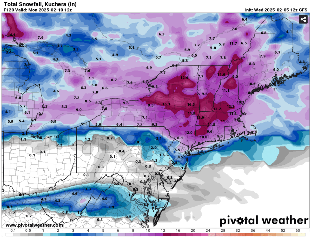
A foot of snow is forecast across part of New York, Massachusetts, Vermont, and New Hampshire states.

The ongoing weather situation in North America is characterized by an Arctic cold pool that covers most of Canada and the northern half of the United States. In contrast, warm air is spread across the South and West. A prolific atmospheric river dumps snow in the Sierra Nevada and excessive rain into portions of California.
A sharp temperature gradient exists between the cold on the north and warmth on the south, extending from Colorado to Oklahoma and curving east towards the East Coast.
A frontal wave is seen over the Northern Plains, gradually moving towards the Upper Midwest and the Great Lakes on Thursday through Friday.

Behind this wave, another more significant upper-level disturbance is forecast for the weekend. Its core will move from Ontario, Canada, across the Northeast U.S., resulting in a significant winter storm, Garnett.
This short video animation provides an overview of the weather conditions across the continent over the weekend and early next week. On Sunday, an intense snowstorm is seen across the Northeast.
Before we dig into details on the next significant winter storm evolution, let’s discuss the main trigger behind this wintry pattern over North America this season. The Polar Vortex aloft is very intense this year, and its southern lobe has shifted above the Canadian Arctic, bursting cold outbreaks towards the U.S.
What is the Polar Vortex?
The Earth’s atmosphere has six layers around the planet. Most of the dynamics for our daily weather occur in the lowest two layers, known as the troposphere and the stratosphere.

Another essential feature in the stratosphere, which makes our weather even more variable, often triggers significant large-scale and long-lasting winter weather events. This is the Polar Vortex—an enormous, tri-dimensional ring of powerful winds moving through the sky above us. The Polar Vortex is spinning around the North Pole, grazing through the air at about 20-50 km above the Earth’s surface with violent wind speed.
The troposphere and stratosphere are crucial for our climate. The Polar Vortex covers most of the bottom half of the atmosphere. Since the vortex extends from the middle of Earth’s troposphere into the stratosphere layer, it significantly affects winter weather across high and mid-latitudes yearly.

The Polar Vortex is most substantial during winter in the Northern and Southern Hemispheres. Although it spins well above our heads, it remains closely connected with the lowest parts of our atmosphere. Thus, it influences our daily weather in many ways, as it generally functions as one sizeable hemispheric circulation.
The Polar Vortex has triggered the most intense weather systems, from frigid cold outbreaks and winter storms in Canada and the United States to Asia and Europe. Although it affects the whole Northern Hemisphere, its main impact occurs where the southern lobe of the vortex is located.

The active and strong Polar Vortex during the Winter season 2024/25 was the main trigger behind the historic cold outbreaks in Siberia, where temperatures plunged below -65 °F at the beginning of January.
Then, the most intense part of the vortex, the southern lobe, shifted to the North American side of the northern hemisphere.
A strong upper wave grazes across the Northeast U.S. for the weekend, resulting in a significant winter storm
As part of the sizeable upper-level circulation over North America, associated with the strong southern lobe of the Polar Vortex aloft, multiple waves are crossing the continent. Over the weekend, one strong wave will move across south Canada towards the Northeast U.S.
The following chart is a 500 mbar forecast for Sunday. It indicates a pronounced wave across eastern Canada, with its core over the Northeast U.S. This is where the more significant weather will develop.

As the wave travels across the northern tier of the United States and southern Canada, it deepens the surface pressure across the central U.S. and tracks across the Ohio Valley towards the Mid-Atlantic states.
Early Sunday morning, the low will be over New York, moving northeast along the coast, passing Boston while deepening. This will deteriorate winter storm Garnett, which is moving across the region.

Here is an 850mbar temperature presentation across the storm in the Northeast, with warm advection on its southern side and significantly colder air mass in its wake.
The clash of the two air masses will bring intense winter weather, heavy snow, and freezing rain.

Behind the low, high-pressure system builds up and spreads the cold air mass further south across the U.S.
Winter Storm Garnett forecast to blanket the Northeast with a foot of snow on Sunday
Saturday night into early Sunday morning, Winter Storm Garnett will move across the northern part of the Ohio Valley and the Great Lakes toward the Northeast U.S. The center low will track south of the Lakes, defining a sharp temperature contrast between the warmth and the cold to the north.
The following two charts indicate the approximate position of the storm on Saturday night (left) and Sunday morning (right chart). Blue represents heavy snow, while pink indicates a high potential for precipitation as freezing rain.
Further south of the core, across the warm sector, a cold front will likely develop thunderstorms with heavy rain and strong to severe winds on Saturday night. It will track east from Indiana across Ohio to New Jersey and New York.

The sharp temperature gradient along the storm’s path will intensify precipitation. Thus, it will fall as heavy snow to the north of the warm front and freezing rain with sleet to the south.
The most significant amounts of snow are forecast across New York, Massachusetts, Vermont, and New Hampshire. By Sunday afternoon, some areas will likely receive more than a foot of fresh snow; locally, 15-20 inches will be possible.
As mentioned earlier, the deep low also brings a strong warm advection from the south, thus meaning a much warmer air mass in mid-levels will overspread the cold conditions beneath. This is a great scenario to produce freezing rain and sleet.
Significant freezing rain and ice storms are likely across part of New Jersey. Locally, an inch of ice could accumulate by Sunday morning. Travel disruptions, including power outages and falling trees, are likely.
Some freezing rain could also occur over northern Ohio Saturday night.

Conditions will generally improve Sunday afternoon as Winter Storm Garnett ejects the Northeast U.S. and continues on Monday toward Nova Scotia.
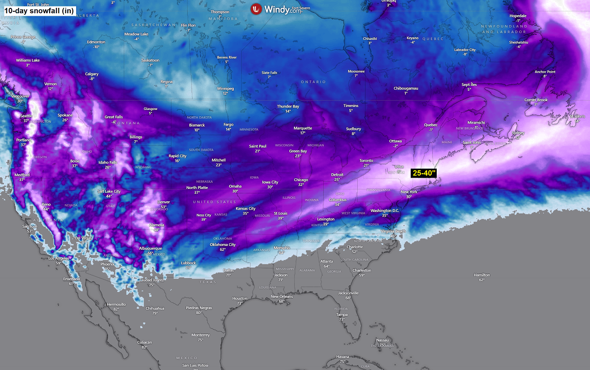
With the active Polar Vortex lobe remaining in place, more winter storms and cold outbreaks will likely follow through mid-February. The following chart summarizes the snow totals over the next few days, indicating that more snow will likely follow across the Northeast and the Great Lakes next week.
We can also expect a lot of snow across the Rockies in the coming 10 days as persistent westerlies with lots of moisture push into the Arctic cold pool, spreading south from Canada.
We are closely monitoring further weather pattern evolution across the U.S. and Canada. The latest model guidance also suggests that a Sudden Stratospheric Warming event could follow soon, with a polar vortex deformation later this month.
Stay tuned for the updates.
Wxcharts, Windy, and Pivotalweather provided images used in this article.