Here is our traditional White Christmas outlook for snow coverage potential across Europe. The beginning of this week brought a cold outbreak into eastern Europe, but recently the weather pattern flipped. The warmer air mass will emerge from the west, but some parts of the European continent will get some fresh snow and have White Christmas Day.
In our main weather forecast overview article published a few days ago, we have discussed the general weather dynamics across Europe, the North Atlantic, and North America. In 2021, both continents are forecast to see wintery weather around Christmas less likely than normal for many as both are now experiencing a return of warmer than normal weather.
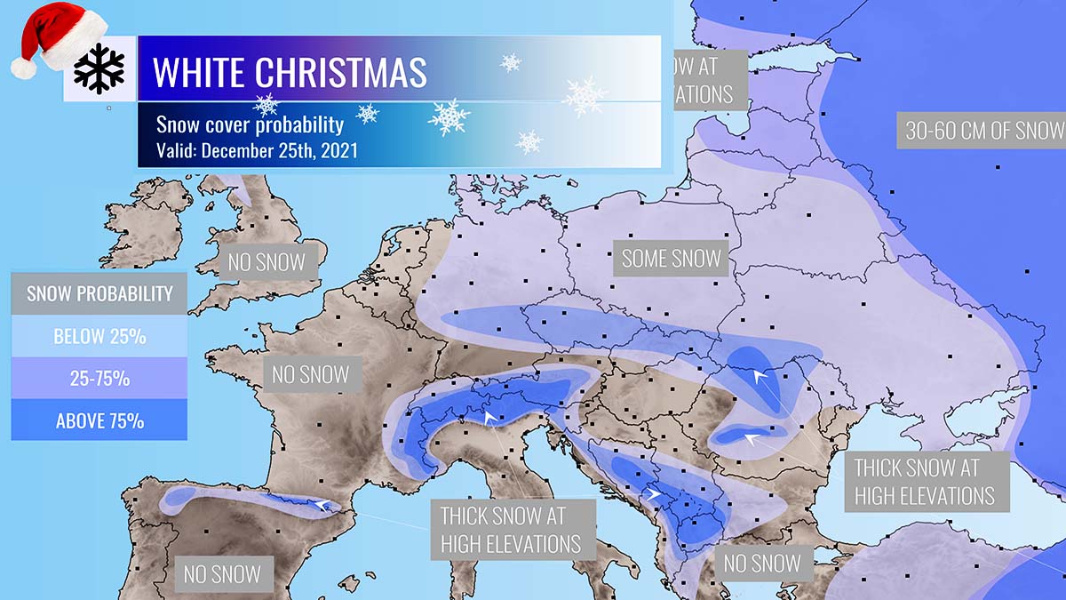
In this discussion now, we are going through a more detailed overview of the White Christmas potential this year, in other words, we are talking about a probability of a snow cover on the ground for Christmas Day 2021 (Saturday, Dec 25th) across Europe.
The ongoing weather pattern over Europe is now flipping from cold to warmer, becoming more progressive with potentially winter weather developing into northern and eastern parts of Europe on Saturday.
The North Atlantic has recently had a strong blocking High, but now a deep trough has developed in the final days before Christmas and established a more westerly (zonal) channel with warm advection from the Atlantic towards the European continent.
Besides the outlook for White Christmas, we also discuss the background evolution of the overall weather pattern for Christmas Day this year. In this video below, we can see the animation of the 10-day pattern evolution with temperature and precipitation with snow forecast over Europe.
With the pattern flip, as deep trough over the eastern half of Europe and the Atlantic Low marge together, a cold front drags south across Germany, Czechia and Slovakia into Ukraine, bringing some fresh snow right on Christmas Day. Let’s go step by step how this pattern over Europe actually pans out for the Christmas holidays this year.
CHRISTMAS DAY EUROPE WEATHER PATTERN
A powerful upper-level trough develops over northern and eastern Europe, while a deepening depression is forming over the Nort Atlantic after the strong High has shifted towards the Arctic region.
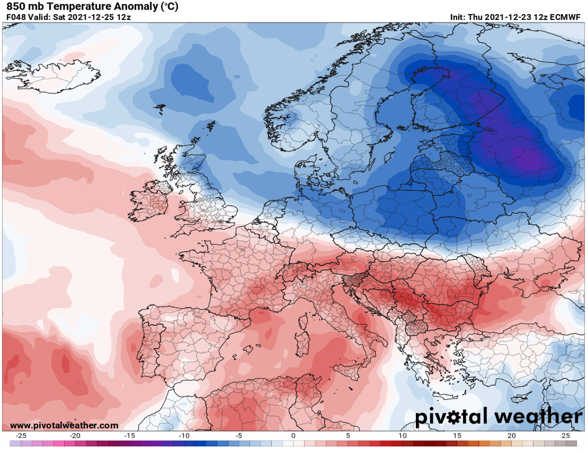
This allows a strong cold advection towards northern Europe but the zonal flow brings much warmer weather into continental Europe farther south.
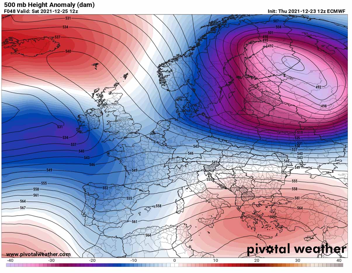
Both combined together limit the interaction of more moist air from the west with the cold from the north, so the general weather picture across the western and southern half of Europe remains warmer than normal.
This pattern evolution translates well also into the lowest levels, with strong surface low-pressure systems dominating the North Atlantic, as well as also northern and eastern Europe, and northwest Russia.
Higher pressure remains across the deep south, from the south into the eastern Mediterranean and the Middle East. This can hint as that in between these large scale features, the general flow of the air mass will be more zonal, so from the west to east. Which typically brings warm weather over the continent.
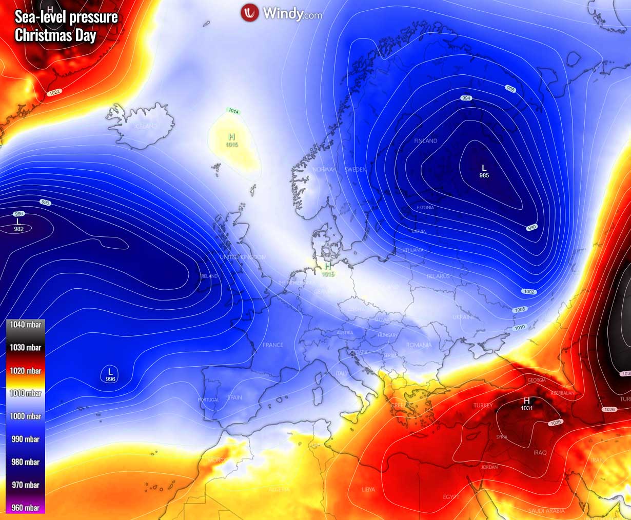
So the Low over the North Atlantic helps the much warmer air mass to spread into western and southern Europe, also across central Europe. The frontal system emerging into central Europe and the northern Mediterranean will bring quite a lot of rain over the Christmas holidays this weekend.
However, on Christmas Day, Saturday, Dec 25th, the cold front extending from northwestern Russia across southern Poland to central Germany will bring some fresh snow. The swath seems roughly from west-central Germany across Czechia, Slovakia, southern Poland across Ukraine into western Russia.
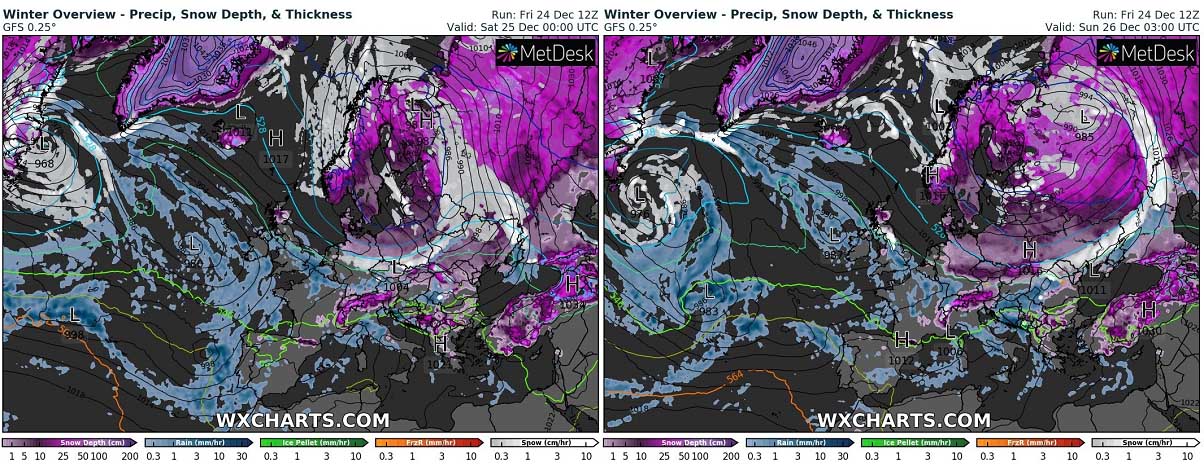
How much snow can accumulate depends a lot on the local topography and where the precipitation will be the most intense along the front (the white swath on the chart above). Both global models ECMWF and the GFS, as well as the regional high-resolution models ICON-EU and ARPEGE, hint that about 5-15 cm will locally be possible, maybe more where orographic features will add more lifting and heavier snow.
WHITE CHRISTMAS HISTORIC POTENTIAL
Let’s first discuss about the historical odds to experience a white Christmas across Europe. We define this as having measurable snow on the ground on December 25th.
To experience a white Christmas across Europe is actually a quite rare event. For those younger readers, one could say ‘Christmas has been without snow for years’. Indeed, unfortunately, the white Christmas event is becoming more of an exception than not over the last decade or two.
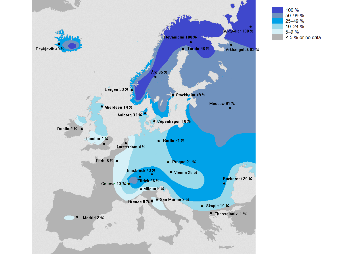
We can see some encouraging probabilities, but looking closer at those statistics, most of Europe actually has a very low chance to see snow on Christmas day.
As we can see from the attached chart above, about 10 % of Europeans live in the areas where Christmas Day has snow on the ground on Dec 25th. Typically the white Christmas is warranted over parts of Scandinavia or more precisely, over the Lapland (that area is covering northern Norway, Sweden, and Finland).
Do you remember those white Christmas cards, they are always pictured as snowy. They come from Lapland, together with Santa :)
Long-term statistics for other parts of Europe like England, France, Germany, the Balkan peninsula hint that the chances for white Christmas are statistically very poor there. Having snow on Christmas is statistically almost non-existing across most of southern and southwestern Europe.
If we make a deeper look for the UK, the last widespread white Christmas event was in 2010. The event was actually was an extremely unusual event, as not only the snow on the ground was reported at 83 percent of the official weather stations network, but the mix of snow or sleet was also reported at 19 % of those stations. This has brought the highest amount of stations ever recorded snow on a single day in the UK.
Over the entire 20th century, the city of London only had 4 white Christmas days, those that happened in 1927, 1938, 1970, and 1981. This can show us a clear idea of why there is only a 4 % chance for snowfall on Christmas day in southern England.
Take a look at another interesting fact from the map above, comparing central Spain (Madrid area) and Dublin (Ireland). Dublin is located quite far north of Madrid (Spain), but the chances for snow covering the ground on a Christmas day are minimal, only 2 % for both areas. Madrid is located at a much higher altitude than Dublin, that’s why.
Now, let’s make a deeper analysis and the weather forecast with the potential of a White Christmas day for this winter 2021/2022 across Europe.
WHITE CHRISTMAS OUTLOOK 2021
The general weather picture across Europe this year is rather complex. While the snow coverage situation across the northern and eastern part of the European continent is forecast to improve with the winter weather on Christmas Day, the rest of the continent is losing the battle against the much warmer air mass arriving with the zonal flow from the North Atlantic.
Below is our traditional Severe Weather Europe outlook with the probability of White Christmas 2021:
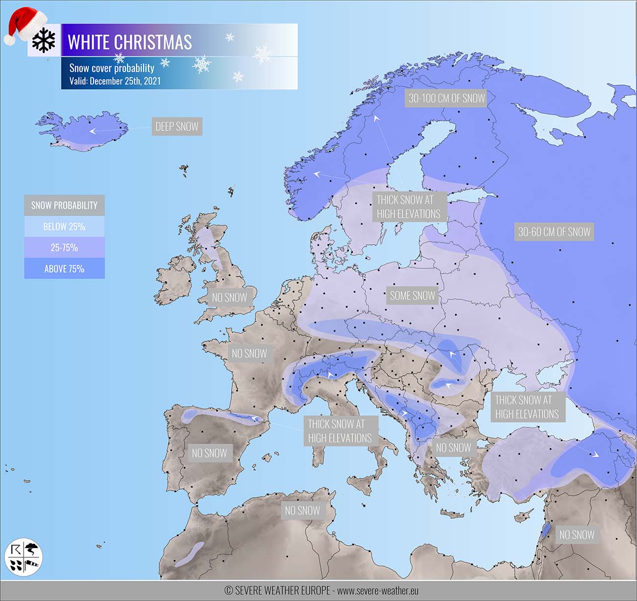
Actually, the situation for Christmas Day across Europe this year is again, similar to 2020, not too impressive. The snow on the ground is mainly forecasted and limited to the mountain ranges and far northern Europe. Especially over Scandinavia and Iceland. Also across parts of eastern Europe this year, however.
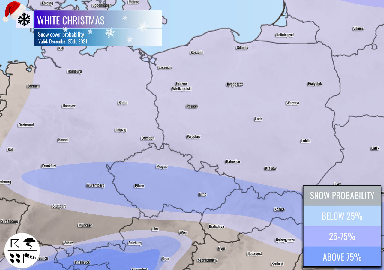
CENTRAL EUROPE AND THE ALPS
If we take a closer look at the snow coverage forecast across central Europe and the Alps, we can see the highest probabilities are indeed over the Alps as deep snow has accumulated over the past weeks. Quite some decent amount of snow also remains over the western Balkan peninsula, despite warm and rainy days over the weekend.
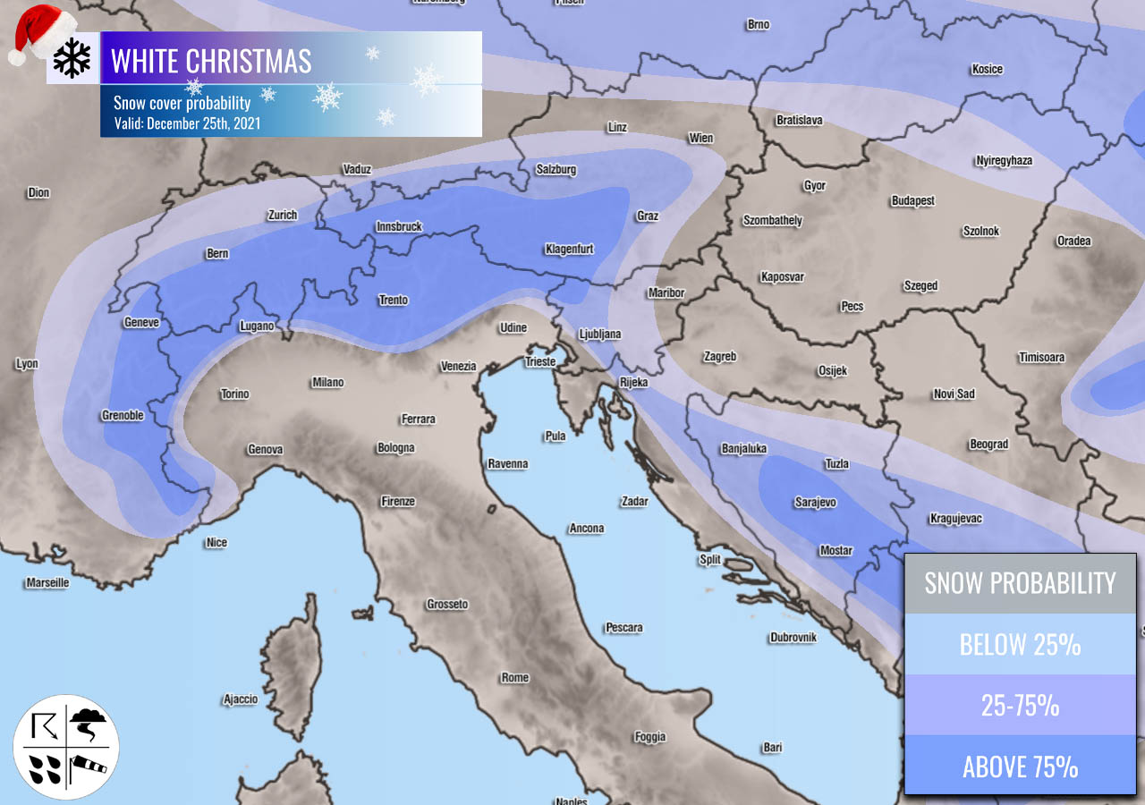
While the warmer weather will be limited to the south and west of Europe, a cold front with enough low temperatures will lead to snowfall across parts of Germany, Czechia, Slovakia to Ukraine. A swath of fresh snow is quite likely to develop along the front on Saturday.
Looking over the potential snow depth on Christmas Day in the central Europe region, we can see that a significant snow depth remains over the Alps. higher mountains have 100-200 cm of snow already, as well as some closed Alpine valleys. 20-30 cm could still remain on the ground in the western Balkan’s higher terrain.
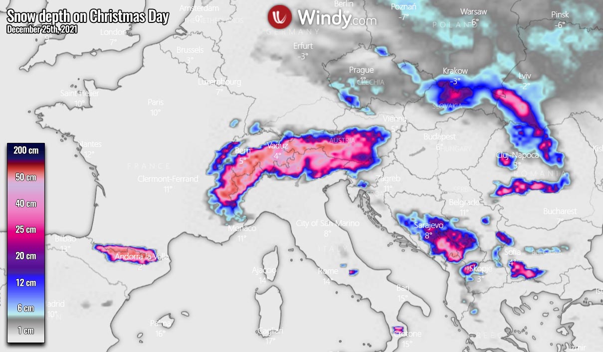
Quite high snowfall accumulations remain across the Carpathian mountains, as well as farther north into Slovakia, western Ukraine, and the High Tatras. These areas will also be covered with fresh snow on Saturday.
SCANDINAVIA AND THE BALTIC REGION
Most of the Scandinavia peninsula, but excluding southern Sweden, Denmark, and the coastal areas of the Baltic Sea region, is having a huge amount of snow coverage. Although the highest amounts are across the higher terrain of western Scandinavia (about 50-80 cm of snow depth or even more (a few meters) in southwestern Norway due to typical La Nina snow max), especially Lapland is having very deep snow.
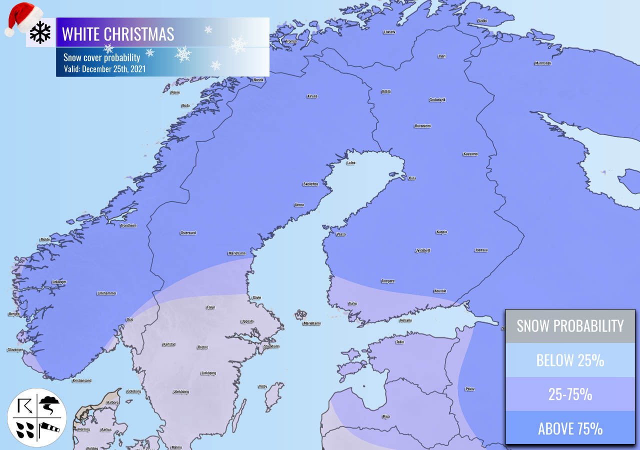
The deep snowpack is extending also across central Sweden and also across whole Finland. With temperatures well below zero. Basically, the Fennoscandia is experiencing deep snow coverage this winter and Christmas holidays.

A few cm of fresh snow seems also possible over some parts of northern Europe due to the large deep trough that is dominating the weather around Christmas. While the amounts are not big, some fresh amounts will quickly increase the depth due to very dry snow.
IBERIA PENINSULA (SPAIN AND PORTUGAL)
Taking a closer look at southwestern Europe and the Iberian peninsula, the snow coverage on Christmas day will only remain over the higher terrain of the Pyrenees and the Cantabrian mountain range.
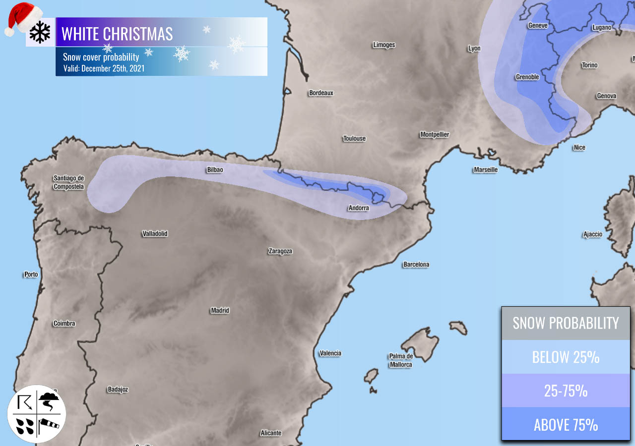
Due to the arrival of the much warmer Atlantic weather over the weekend, new snow is not expected across Spain or southern France, excluding the mountain ranges.
WESTERN EUROPE
Again, similar to Christmas last year, there are very low chances for a white Christmas across UK and Ireland in 2021. The weather model charts hint at some low potential of snowfall across the northwestern UK and over Scotland. But it seems the chances are reasonable only over Scottish Highlands.
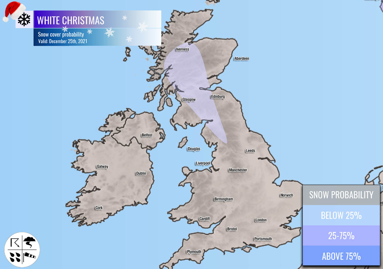
So, in general, the chances for snow coverage over Northern Ireland, Ireland, Wales, and south-central England and below 1% or basically zero due to the warmth that is spreading recently and extends over the holiday weekend.
BALKAN PENINSULA AND TURKEY
The Balkan peninsula has two areas where snow on the ground for Christmas is likely this year. One is the western and southwestern part of the peninsula (Albania, North Macedonia, southern Serbia, western Bulgaria) which still has some snow from the recent events despite the fast melting these days. No fresh snow is forecast over the weekend.
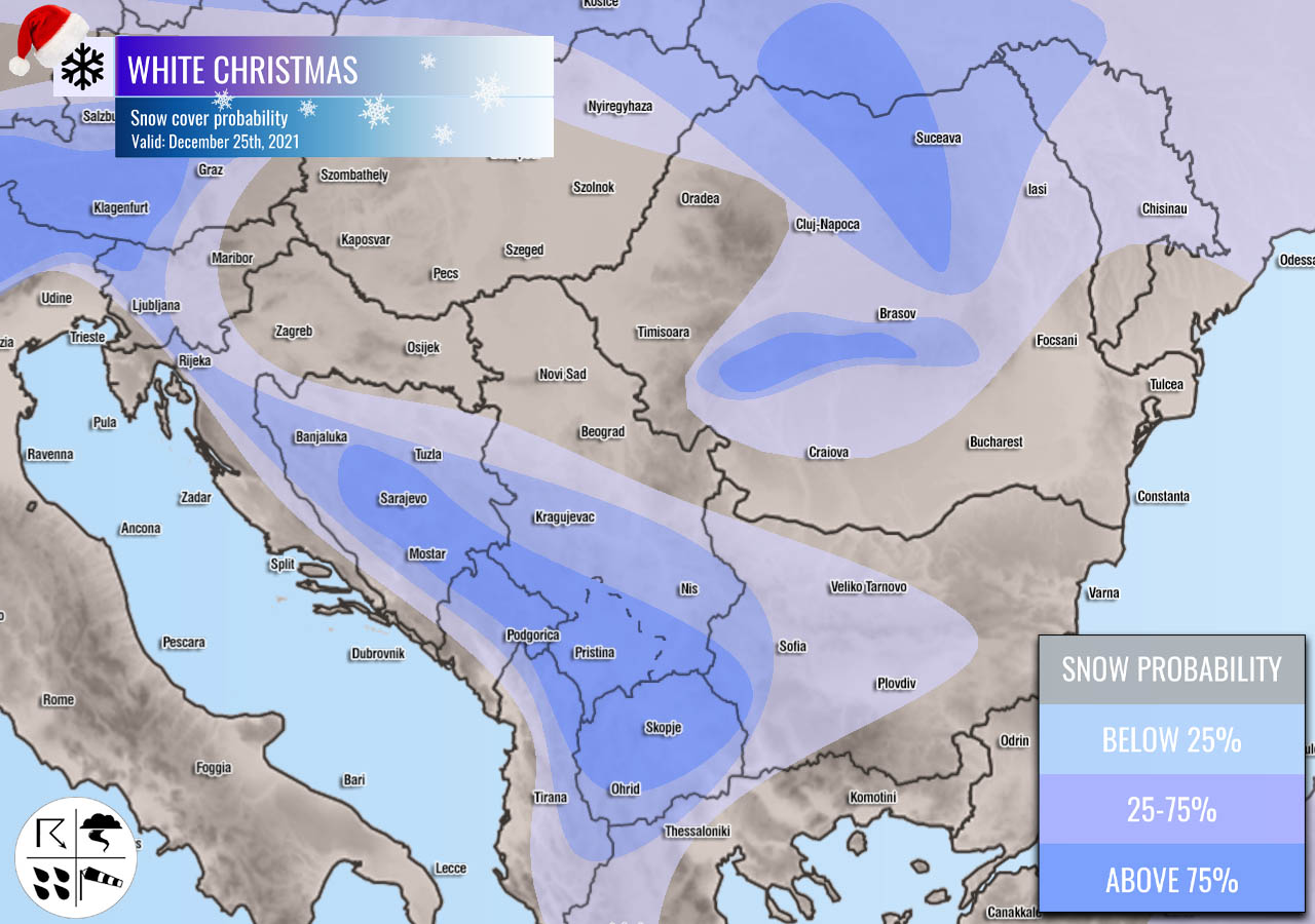
The other area are the Romanian Carpathian mountains. Those high mountains are already covered in a decent snow depth, which will indeed continue on Christmas and some extra snow will arrive with the front on Saturday. Also farther north across the high Tatras, southern Poland, Slovakia, and western Ukraine.
A decent amount of snow si also accumulated across central and especially eastern Turkey, as well as across Georgia. The highest snow depth is spread in the higher elevation of eastern Turkey, counting into 50-100 cm or even more locally.
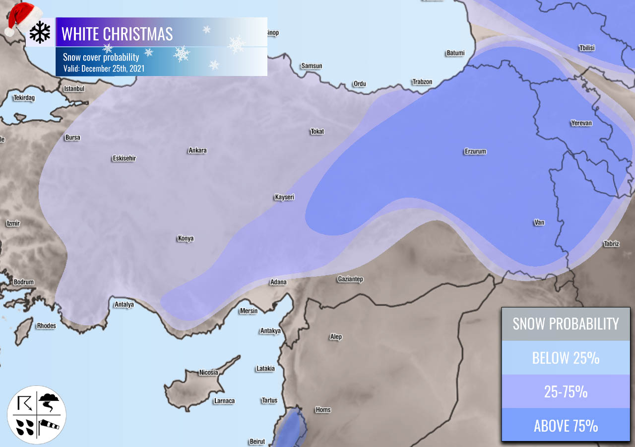
The attached chart below is the snow depth on Christmas Day across the southeastern part of Europe. We can see the clear spots with the highest amount, west-southwest Balkans, the Carpathians but also eastern Turkey and Georgia.

The highest snow is over the Greater Caucasus Mountains, counting in meters which is indeed quite typical there.
WHAT ABOUT WEATHER AND SNOW FORECAST AFTER CHRISTMAS?
But what will happen with the weather pattern after Christmas and this significant pattern change underway? We are up for a break in the westerly flow towards the end of December, with a very powerful upper-level ridge (High) developing into the European continent. Can you judge what this means? If the next chart isn’t obvious what’s up for the End of 2021…

Exactly. Not again! A potentially record-breaking warmth is increasingly likely to develop across a large part of Europe before December is over. And quite likely also extend into the early days of January 2022!
A much warmer air mass will spread across southern, western, central and also reach the northern and eastern parts of Europe. It seems that the warmest air mass will be across the central parts of the continent, even more than 15 °C above normal for New Year. This is *extreme*!
But as far as the winter weather and snow go, before this warmth happens, there will likely be some fresh snowfall across eastern and northern Europe also in the days after Christmas.

The broad swath of potentially good amount of new snow seems possible from the Carpathians across Ukraine into western Russia. Some massive snow also across western Scandinavia, some also across the Baltic region and the rest of Scandinavia.
Some fresh snow seems also likely across part of west-central Turkey in the coming days.
Northern Iceland should also see a lot of snow due to the strong advection of moist and cold Arctic air mass before December is over, thanks to the prevailing northerly flow developing with the pattern change after the Christmas weekend.
Images used in this article were provided by Windy and Wxcharts.
Severe Weather Europe team wishes everyone a Merry Christmas and Happy Holidays!