A weather pattern change is starting over the Northern Hemisphere, just in time for the final stage of the meteorological Summer. But as the pressure-systems shift, we will see a temperature drop over much of the United States, a heatwave over the Pacific Northwest, and a longwave moving over Europe.
First, we will quickly look at the Summer so far. But then, we will focus mainly on the changing pressure patterns over the Northern Hemisphere and how they will shape our weather as we step closer to the beginning of the meteorological Fall season.

HALFWAY THROUGH SUMMER
Meteorological Summer covers the 3-monthly period of June, July, and August. These are the warmest three months in the Nothern Hemisphere and represent the summer season in the statistics.
We are already past two-thirds of Summer, so we can look back at how the weather patterns have evolved so far.
The pressure pattern behind June and July has featured high-pressure zones over much of the United States and Europe. In addition, we can see a deep low-pressure system over Greenland and a high-pressure area expanding from Aleutians to northern Canada.

Below we have the temperature anomaly analysis for the same period. We can see that Summer so far has been warmer than normal in Europe and most of the United States, and northern Canada. Colder than average temperatures were present over Greenland and parts of eastern Canada.

Precipitation-wise, we see drier conditions in the southern United States, the midwest, and parts of western and northern Canada. But there was more rainfall in the southwestern United States, the Pacific Northwest, and over the Ohio river valley.
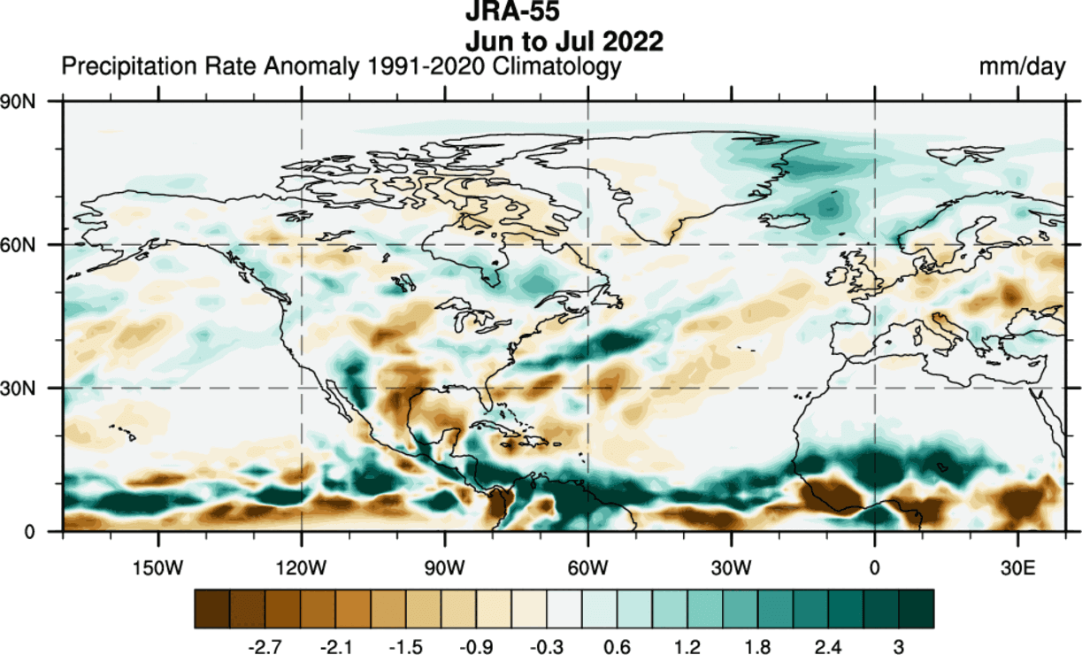
Over Europe, we see mostly drier conditions. The exceptions are certain regions with more convective activity/storms in western and central parts. Scandinavia has mostly seen more precipitation than usual.
But what was driving the Summer weather thus far, and how will it shape the rest of the season?
WEATHER DRIVERS
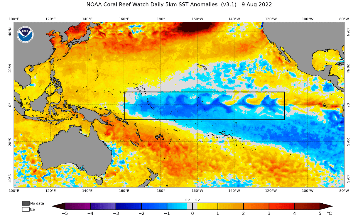
La Nina is one of the main factors behind the weather patterns this Summer. We can see it as an area of cold ocean anomalies in the tropical Pacific Ocean. The ocean temperature analysis by NOAA below nicely reveals the active La Nina phase.
But while the La Nina has a low-frequency background influence, many shorter-period atmospheric waves circulate the tropics.
ATMOSPHERIC WAVES
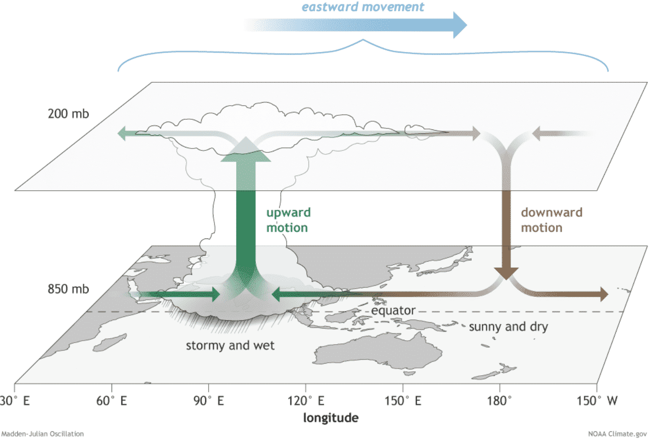
A lot of the global variability is driven by invisible tropical “waves” in the atmosphere. The largest and most dominant source of short-term variability from the tropical regions is the Madden-Julian Oscillation wave (MJO).
MJO is an eastward-moving disturbance of thunderstorms, clouds, rain, winds, and pressure anomalies. It moves across the Earth on the equator in about 30 to 60 days.
It also has the power to influence the weather patterns further north over the North Hemisphere, as there is a strong connection between the tropics and the global weather.
The MJO consists of two parts: one is the enhanced rainfall (wet) phase, and the other is the suppressed rainfall (dry) phase. Image by NOAA Climate.
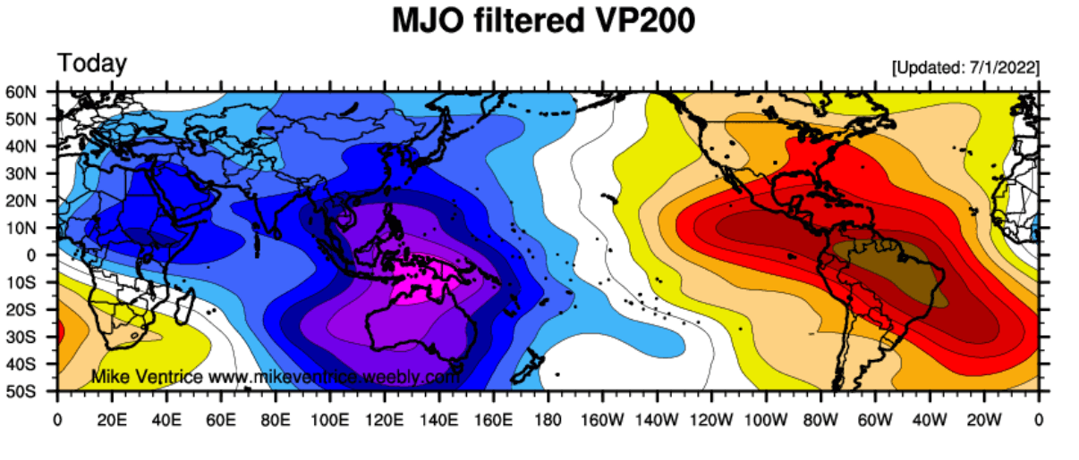
The MJO wave was an important part of the Summer weather patterns so far, as it was active over June and July. The image below shows a strong, active phase of MJO in July, with upward motion over the western Pacific and suppressed activity over the Americas.
We have also produced a video animation showing the global precipitable water. You can see how the tropical regions connect with the mid-latitudes, creating “atmospheric rivers” and connecting to the global weather system.
Below is an ECMWF ensemble forecast of the MJO activity. It is quite easy to read, as we can see in which phases the wave is moving and on which day. If the wave is within the central circle, it is considered weak.
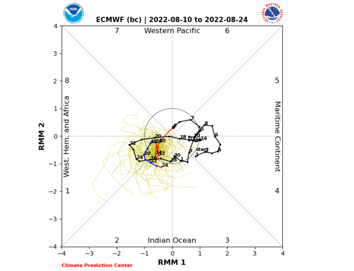
You can see past activity with the black lines. But the forecast shows little activity in the short-term forecast. This means that most of August will go by without a strong MJO influence.
But what will the rest of the Summer look like, and what does the forecast show for the start of the meteorological Fall season?
A PATTERN CHANGE
With the MJO out of the equation, for now, we can observe the North Hemisphere circulation by looking at the Arctic Oscillation (AO).
The Arctic Oscillation index explains the pressure pattern and circulation over the North Pole. A positive phase means a stronger and more stable lower level polar circulation, while a negative phase means high pressure over the polar regions and a disrupted flow.
This is much more profound during the Winter when the pressure patterns are stronger, and the Polar Vortex is active. A positive or negative phase of the AO can open or close “the gates of the Arctic”, releasing cold air into the United States and Europe.
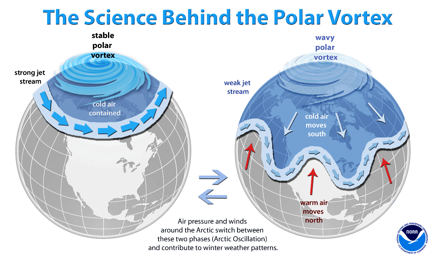
The positive phase means stable circulation and contains cold air. Negative AO means the circulation is weak, and the jet stream is wavy, so cold air can escape the polar regions during the Winter.
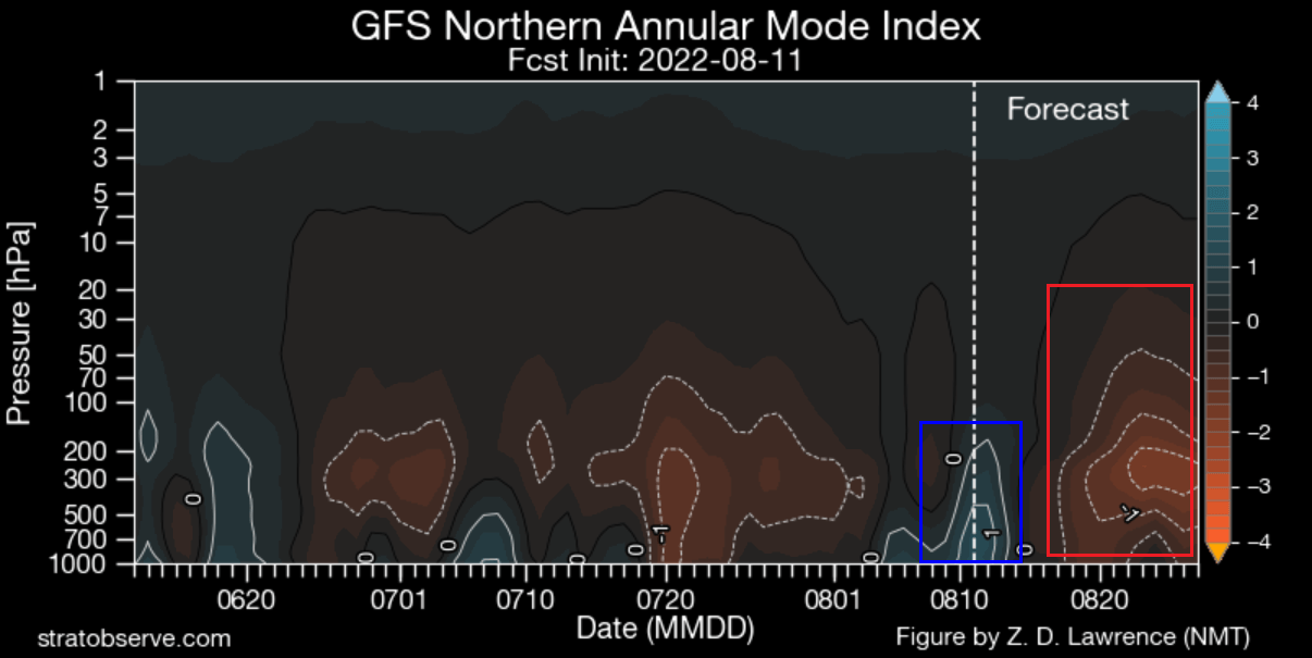
While there are no cold air outbreaks during the Summer, the Arctic Oscillation is still used to indicate the weather pattern development and overall circulation. As seen in the forecast below, we can see that we are in a positive AO phase now, but the forecast calls for a negative phase.

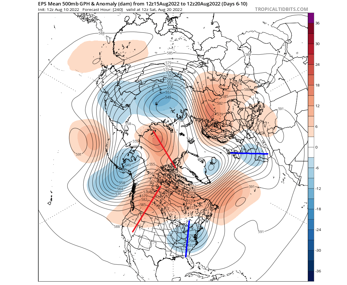
We can see on the atmospheric pressure anomaly map below how the pattern will change. Currently, we have the positive mode (blue square), but high latitude blocking (red square) is set to appear by mid-month, creating a more disrupted hemispheric flow. Image by StratObserve.
Looking at the pressure anomaly forecast for this week, you can see the low-pressure zone over the polar regions. That is the positive AO mode, of course, more confined to the arctic circle in Summer. Around it, we have a strong high-pressure zone over northern Europe, creating a rex-block pattern.

Over North America, we can see a strong ridge over the western United States, expanding further north into Canada. In response, we have a low-pressure area (trough) standing over the eastern United States.
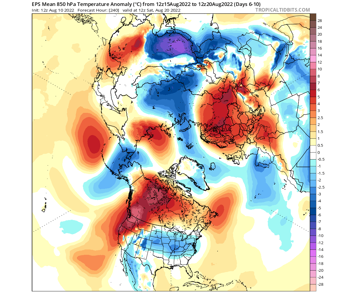
Looking at the 850mb temperature anomalies, we can first see a cold anomaly in the Arctic, thanks to the strong low-pressure system. Then, the strong warm anomalies enter western and northern Europe under the high-pressure zone.

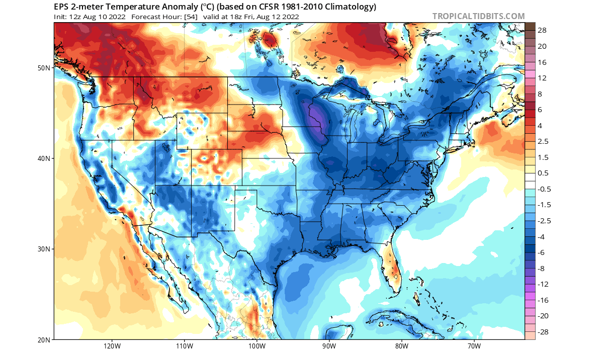
An interesting temperature pattern has started to develop in the United States. Cooler air starts to come down into the eastern parts of the country under the low-pressure area. Warm anomalies are building in the northwestern United States and western Canada.
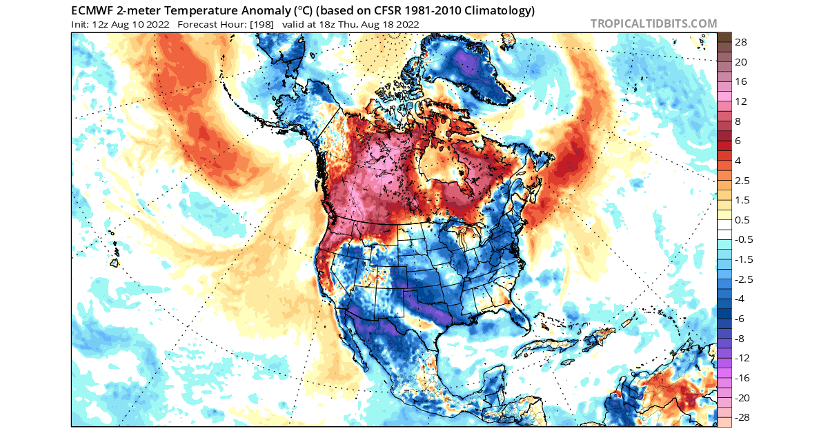
The surface temperature forecast across the United States shows cooler than normal morning temperatures over much of the eastern and southern United States. In Winter, such a pattern could create a decent cold air outbreak.
Precipitation-wise over North America, we can see more rainfall over the Midwest and the western United States. Over the southern United States, we mainly see drier conditions over the weekend and early next week.

WEATHER IN LATE AUGUST
Next week, the pressure pattern will change over the polar regions. This reflects the change in the Arctic Oscillation phase from positive to negative. You can see the high-pressure building into the polar region, replacing the prior low-pressure area.
Two strong ridges connect across the polar circle. One over the Arctic Ocean and the strengthening ridge over the western United States and Canada. A low-pressure zone amplifies over the eastern United States and western Europe.
Looking at the temperature anomalies, we can first see a cold anomaly extending across the United States as the low-pressure zone regresses westward. Strong heat domes build over the northwestern United States and Canada and over northern and southern Europe.
Over North America, we can see a strong contrast between western Canada and the United States. With the exception of the far northwest, we can see colder than normal daily temperatures over most of the United States.
Higher than normal temperatures are expected to develop under the ridge covering the northwestern United States and Canada. Temperatures over 37 degrees celsius (100F) are expected over the Northwestern United States and over 32 degrees celsius (90F) over southwestern Canada.
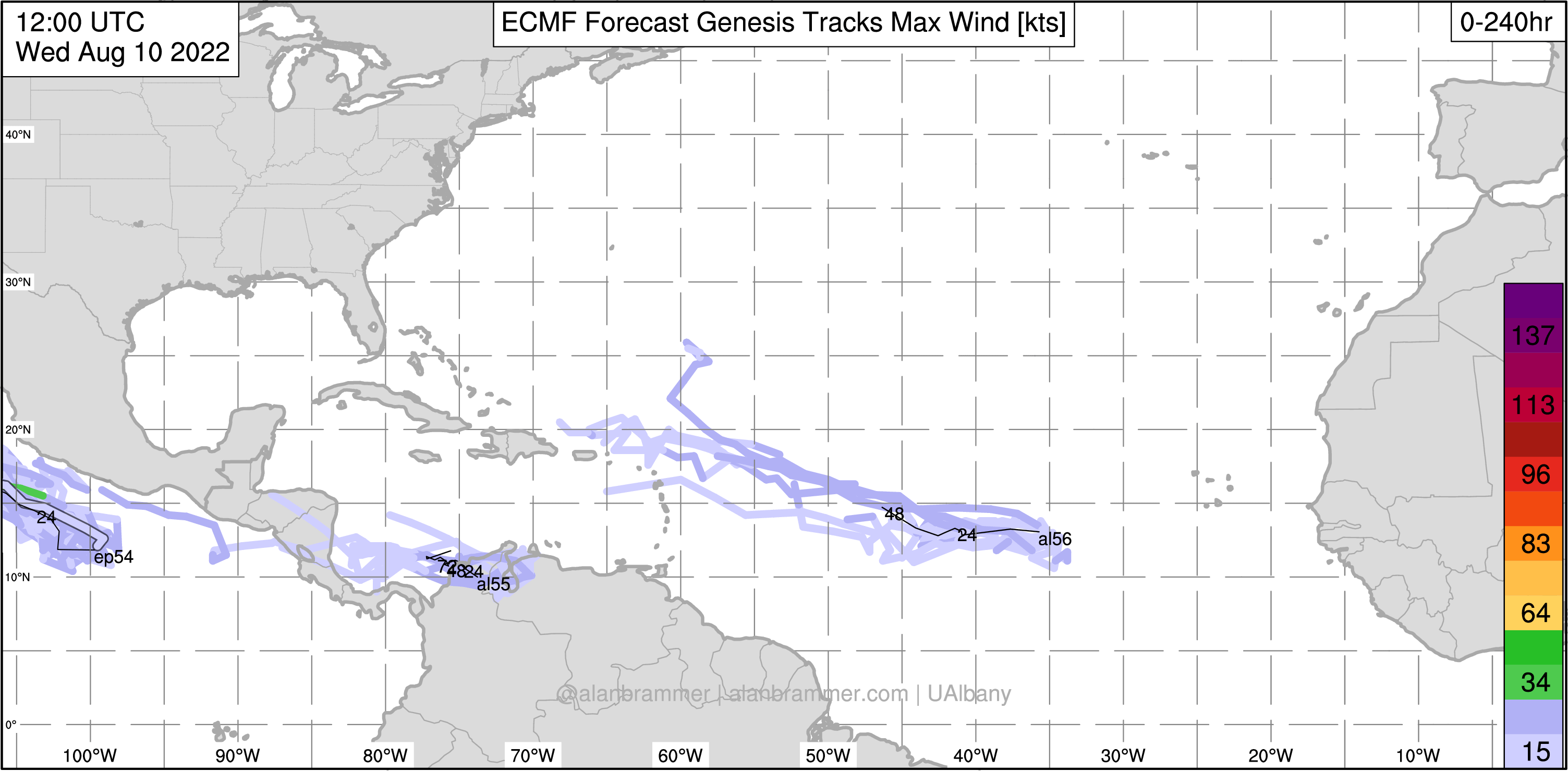
We are also in an ongoing Hurricane season. But looking at the development in the Tropics, we can see no real activity in the near future. The ECMWF ensemble forecast shows no tropical storm formation in the next 10 days.
6-10 DAY OFFICIAL WEATHER OUTLOOK
NOAA regularly releases its weekly forecasts for the United States. Below is the temperature forecast in the 6-10 day range, which covers mid-August. You can see the higher temperatures in the northwestern United States and a cooler than normal Summer over much of the central and eastern part of the country.
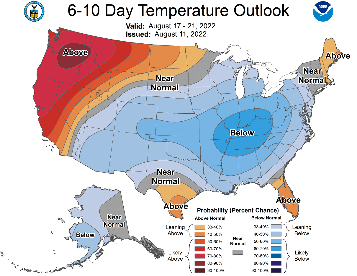
We also have the official precipitation outlook below, which calls for more precipitation over much of the United States, except for the Midwest and the north.

LATE-MONTH WEATHER PATTERN
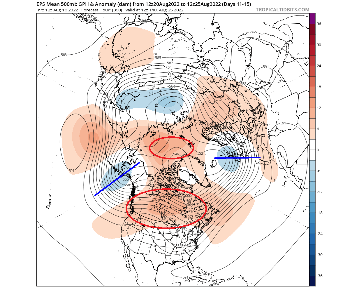
In this period, the ECMWF pressure forecast shows a high-pressure area stabilizing over the polar circle and Canada. This is a typical disruption of circulation, with low-pressure zones circling the Aleutians, the United States, and northwestern Europe.
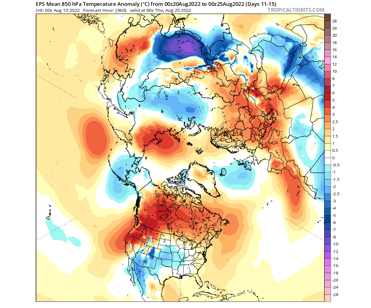
The 850mb temperature anomaly for late-month shows warm anomalies returning over central and western Europe. The heatwave continues over the Pacific Northwest while a cold anomaly drops further back into the central United States.
Below we have a surface temperature anomaly forecast over North America. The forecast calls for colder than normal air spreading into parts of the Midwest and reaching down towards the southern United States. Hotter conditions still prevail over the northwestern United States and southwestern Canada.

NOAA 8-14 DAY WEATHER OUTLOOK
This is also reflected in the official NOAA 8-14 day temperature outlook. NOAA is forecasting cooler than normal conditions over much of the central United States. Warmer weather is forecast to continue over the western United States, with temperatures rising again in the northeast.
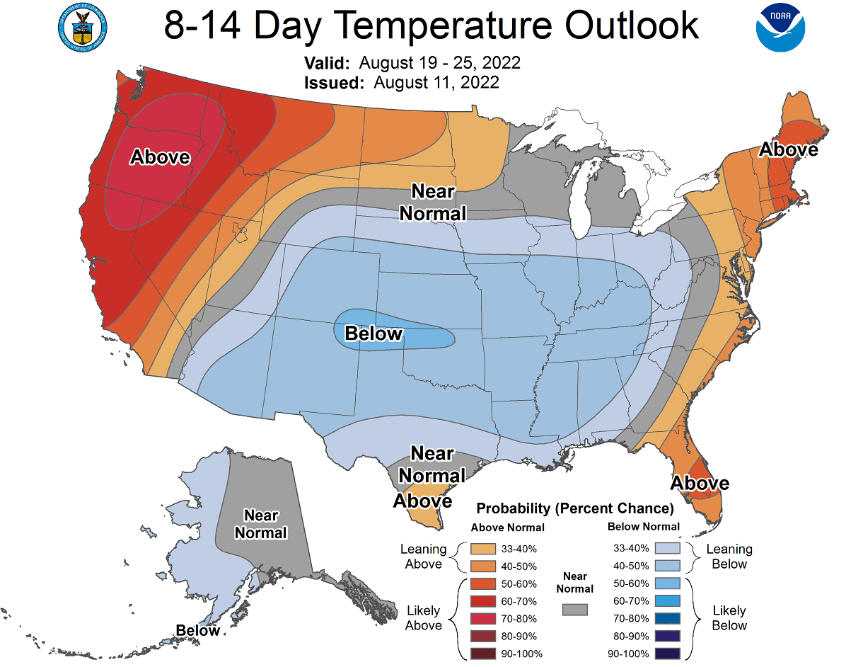
NOAA precipitation outlook also calls for wetter conditions over the southern and eastern United States. The northern part of the country is forecast to receive less precipitation than normal under the influence of the ridge.

EXTENDED RANGE WEATHER
Looking further into the end of August and early September, we will use the ECMWF extended ensemble forecast.
The pressure pattern forecast for the month transition shows a high-pressure area remaining over Canada, also covering the western United States. That hints at possible lower pressure over the eastern United States. In addition, a high-pressure zone extends over northern Europe.
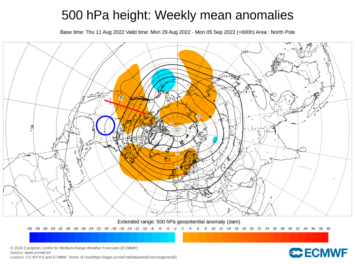
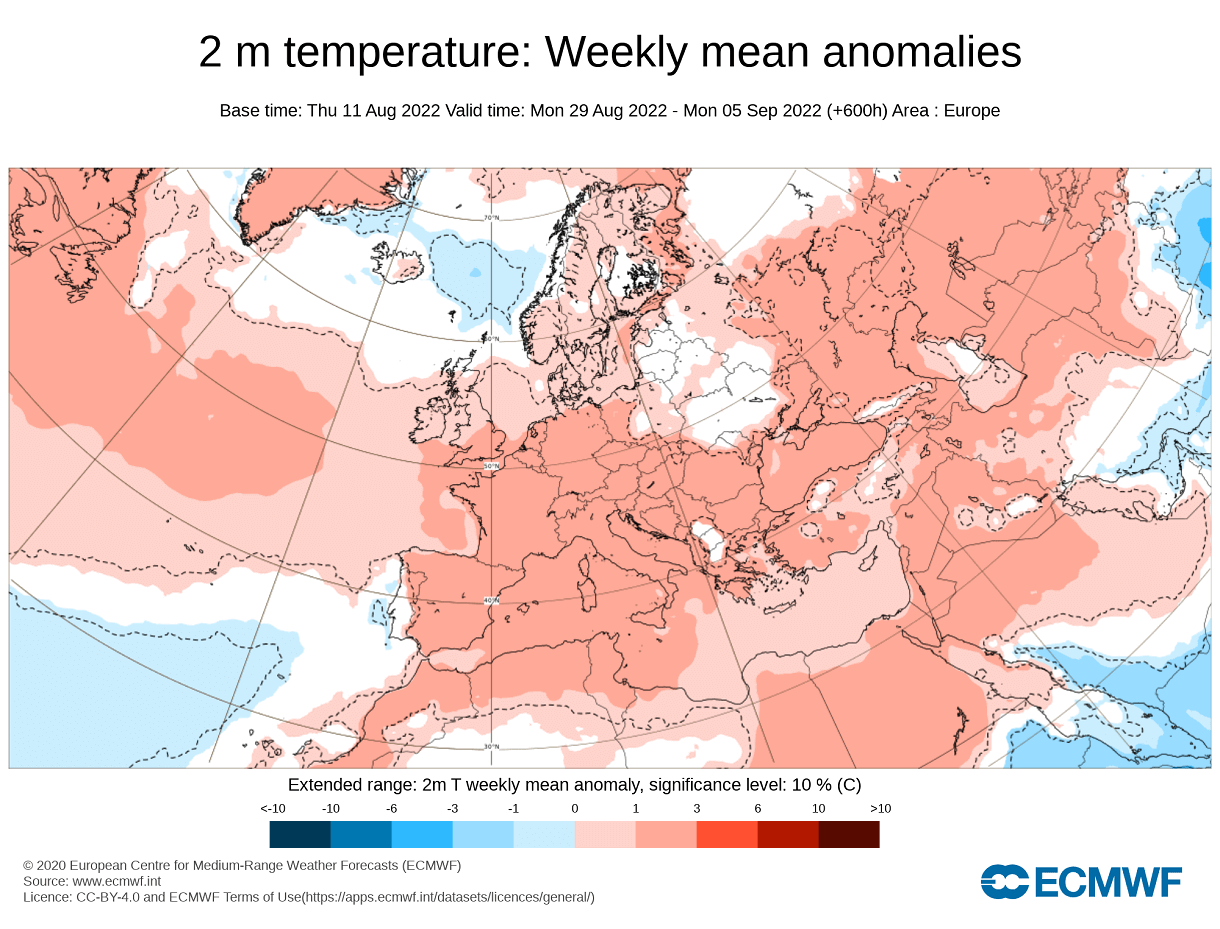
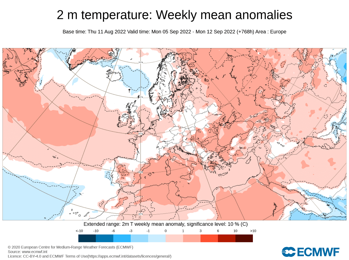
The temperature forecast for Europe shows warm anomalies over much of central and western Europe. But there is no strong warm signal, for now, that would hint at unusually warm/hot weather for the end of the month.
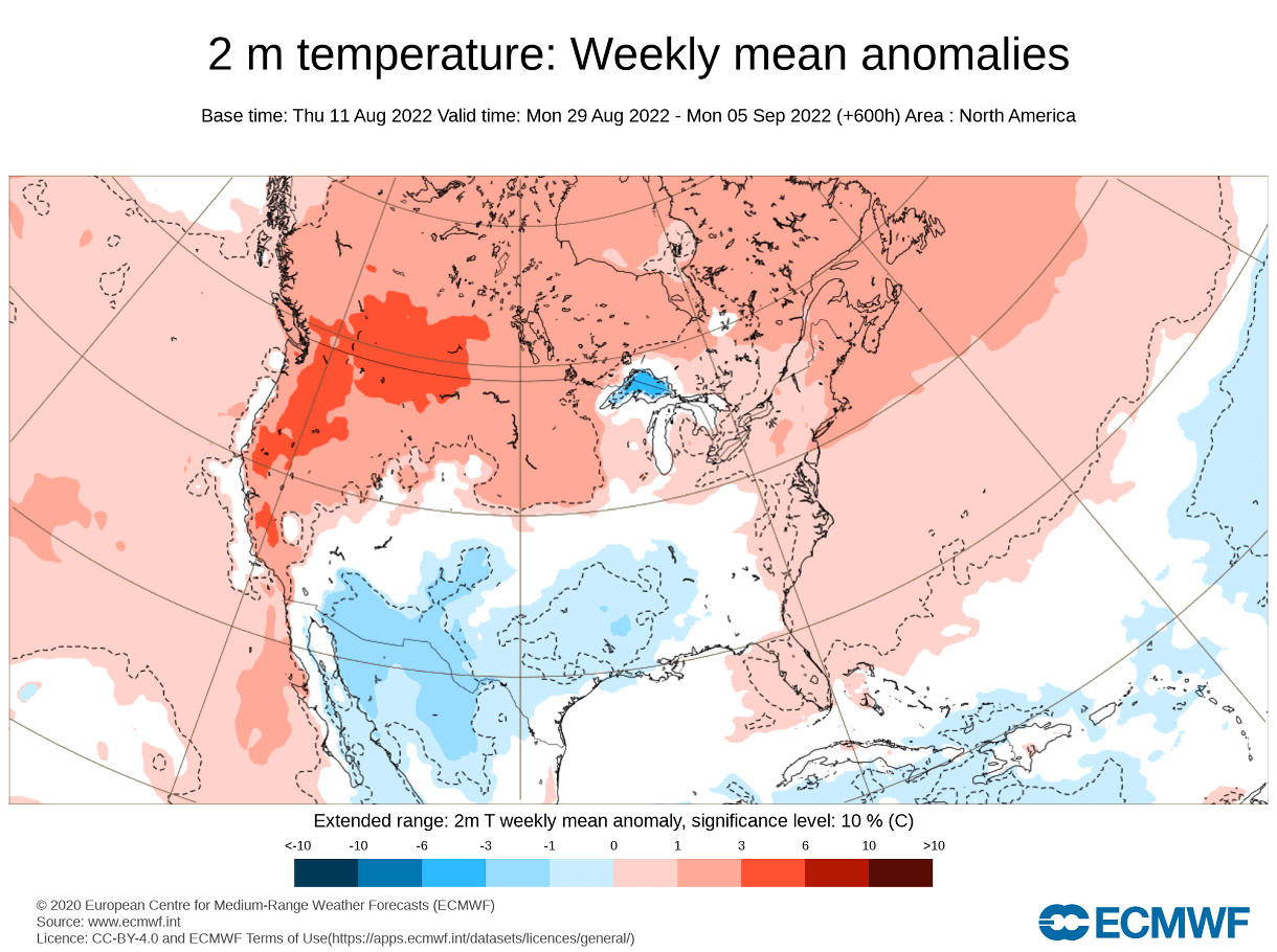
The temperature forecast for North America shows cooler than normal temperatures in the southern half of the United States. Warmer than normal weather is expected to continue over the northwestern United States and southwest Canada under high pressure.
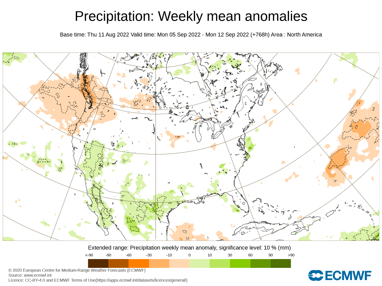
Precipitation-wise, more rainfall is expected in the south-central United States, along with the active monsoon in the southwest. Drier conditions prevail over the northern United States and southern Canada.

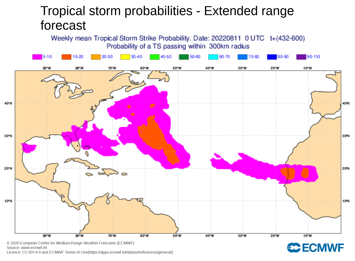
Looking at the tropical development in this range, we have a low probability of tropical storm development. Some indication is shown along the east coast of the United States, but the probability remains very low at the moment.
FROM SUMMER TO AUTUMN
September marks the first month of the meteorological Fall. The meteorological season covers 3 months, September, October, and November. So, the transition from August to September marks the shift from meteorological Summer to Fall.
The extended forecast trend for early Sept shows continued high pressure over western Canada and a likely low-pressure response in the southern United States. This would promote a continued northerly flow into the southern United States.

Over Europe, we see the high-pressure zone easing away from northern Europe back into the North Atlantic. This could indicate a more unstable pattern over the continent.
Looking at the temperature forecast for Europe in this period, the warm anomalies over the central parts are almost gone. This confirms a more unstable pattern is likely over the continent, with a shift towards a more Autumn configuration.
Looking at the temperature forecast for North America, we see the warm anomalies remaining over the northwestern and northeastern United States. However, a cooler than normal area remains over the southern part of the country, linked to a likely low-pressure area.

The precipitation forecast shows more precipitation trending in the southern and western parts of the country. Drier conditions prevail in the Pacific Northwest of the United States and southwestern Canada.
In the early parts of September, we still see little in the way of any significant development. Some signals are from the east coast up into the northeast, but that is likely not a real or pure tropical low-pressure development.

But as we move into the Fall, what do the latest seasonal trends show for the upcoming weather season?
AUTUMN SEASON 2022 OUTLOOK
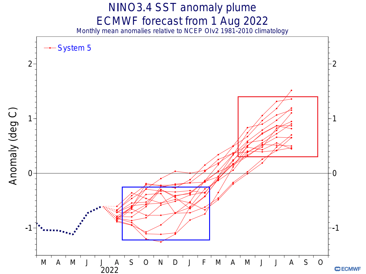
Below we have an analysis/forecast graphic by ECMWF, which shows the long-range forecast of the main ENSO region. The La Nina conditions remain over the Fall and Winter seasons. But a weakening of the La Nina is expected for early next year, with an El Nino hint for later in the year.
Another respected ENSO forecast comes from the Australian BOM office. They produced a graph that contains multiple forecasts from different global models. They all agree on a continued negative ENSO phase from Fall into Winter.

There are differences in the strength of the La Nina at this period, but the average forecast from all models agrees on an active moderate event.
A more direct ENSO influence can be found in North America. For this reason, we produced a graphic that combines 10 of the last La Nina Fall seasons, showing the average weather pattern during a La Nina Fall season.
On the pressure anomaly pattern, you can see three areas of high-pressure anomalies and a low-pressure zone over Alaska and western Canada.
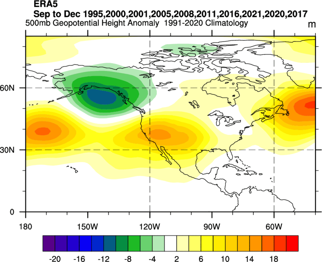
High-pressure anomaly in the North Pacific is more of a classical La Nina signature in all seasons. But in autumn, the high-pressure area over the western United States is also often seen. There is also a high-pressure anomaly in the North Atlantic.
ECMWF FALL 2022 FORECAST
The pressure anomaly forecast shows the typical La Nina high-pressure system in the North Pacific, with another high over the western United States and the North Atlantic. This is a similar pattern to the historical analysis we have done above. It also has a low-pressure zone hinted over Alaska and western Canada.
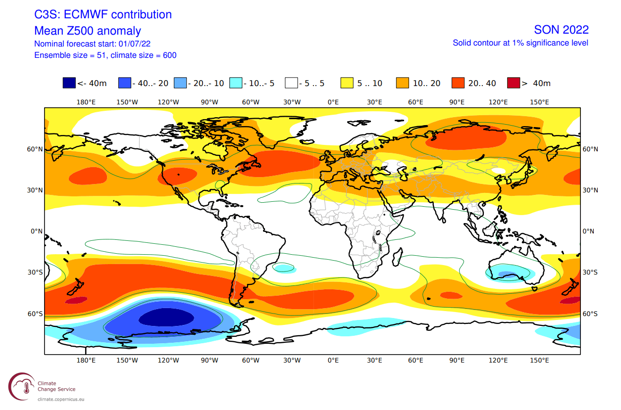
Looking at the European sector, we have a high-pressure zone extending from the North Atlantic over Europe. As a response, the low-pressure zone is moved further up to the north.
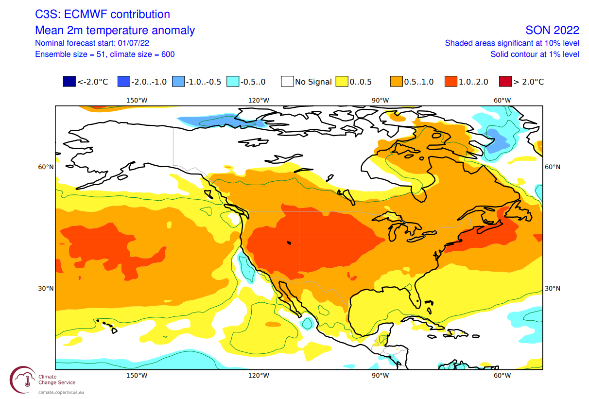
When we look at the global air temperature anomaly distribution, we can see the warmer anomalies over the western United States and Europe. Northwestern Canada and Alaska are in a neutral zone, which will likely turn cooler in the next updates.

As seen in the historical analysis, you can also see weaker warm anomalies over the southeastern United States. Overall, this seems to be quite a typical La Nina Fall pattern, confirming its influence on global circulation.
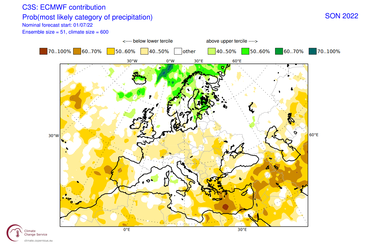
Over Europe, we can see warmer than normal surface temperatures over much of the continent. This is due to a high-pressure area over the North Atlantic and extending into the continent.

Over North America, we see much warmer temperatures under a high-pressure system in the western United States. Warm anomalies extend into the northeastern United States and eastern Canada. But Alaska and northwestern Canada remain neutral to cool under the influence of the polar jet stream.
Precipitation-wise, we can see mostly drier conditions over Europe. More precipitation is forecast over northern Europe, under the influence of a low-pressure zone.
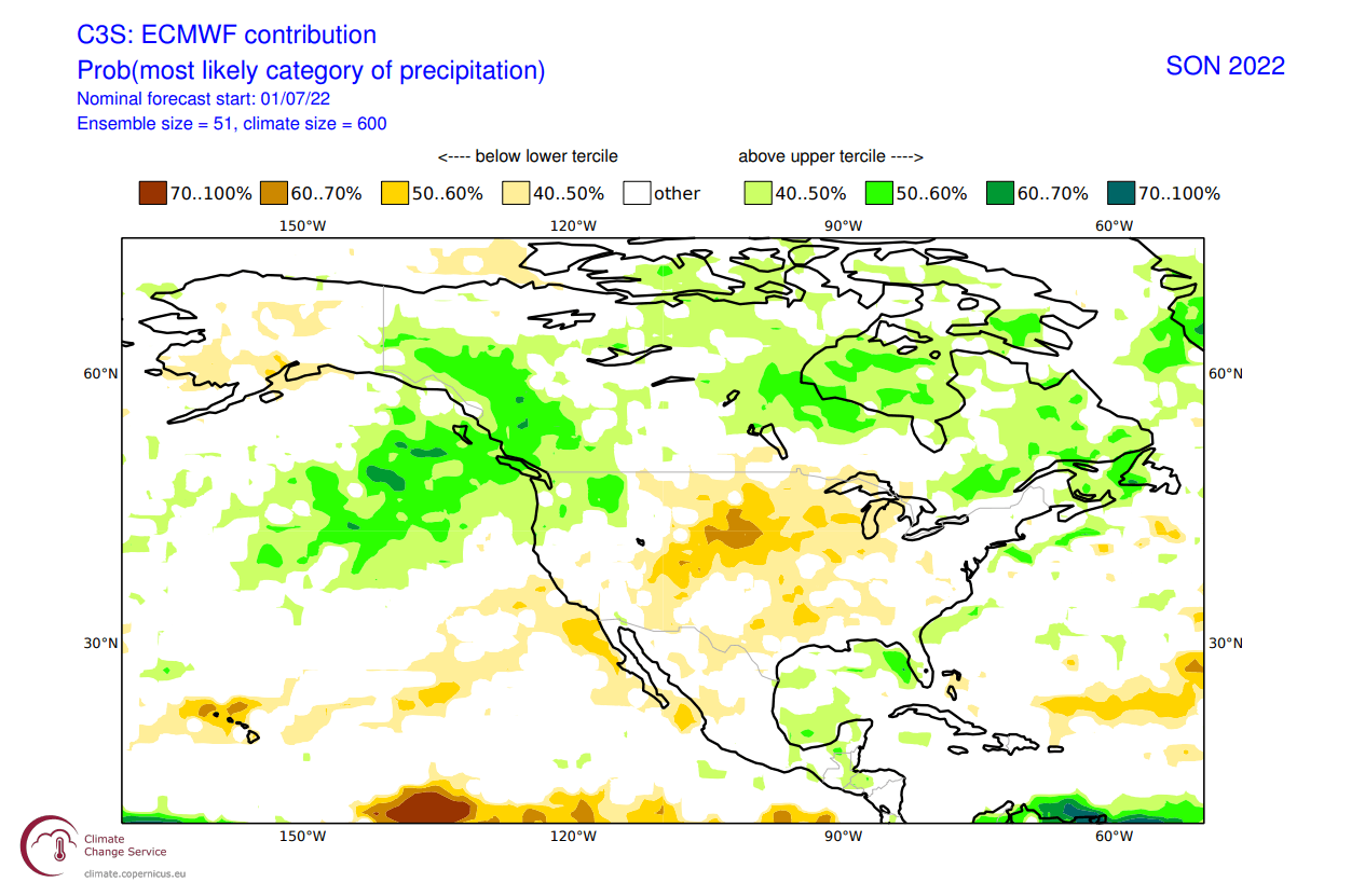
Over North America, we have wetter conditions over the northwestern United States, also expanding over western Canada. The Midwest and the southern United States show a dry signal, while we also see more precipitation over the southeast.
The La Nina influence is expected to grow later in the season, which means a low-pressure area will be further established over western Canada. This could mean early snowfall is likely for parts of the northwest and the northern United States.
Below is the official Fall 2022 outlook from NOAA/CPC for the United States. Temperature-wise, we see the warm west and far northeast standing out, as also seen in the ECMWF forecast.
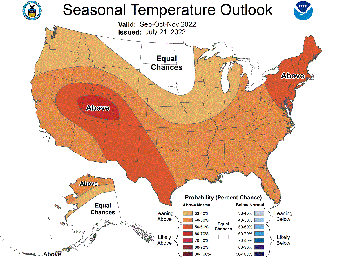
We can also see a neutral temperature zone in the Midwest. That does indicate a chance of more cold fronts coming down from the northwestern United States and western Canada towards the central regions. It could mean earlier snowfall than normal in the northern United States.
Precipitation-wise, the NOAA Fall 2022 outlook shows drier conditions in the western and central United States. Wetter conditions are expected mostly on the east coast of the United States.

The typical issue with a La Nina is typically the support of drought conditions in the southern and western United States. Below we have the latest drought analysis from NOAA, which shows the current drought conditions across the United States.
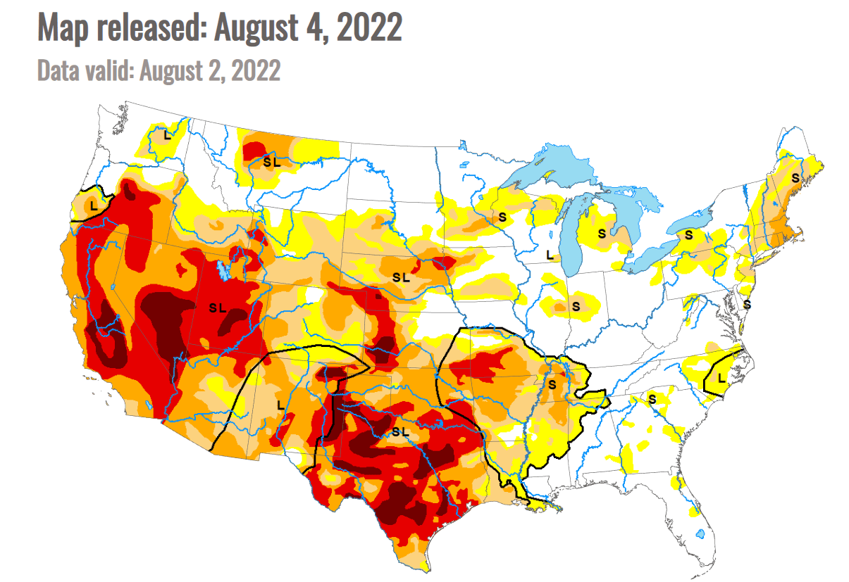
Most of the western half of the United States is already under some drought conditions. The driest conditions prevail in the southern United States. Over the southwest, the monsoon has alleviated some of the drought conditions. However, some drought conditions are also seen in the northeast corner.
We will release regular weekly and monthly updates as fresh forecasts and data are available. So make sure to bookmark our page. Also, if you have seen this article in the Google App (Discover) feed, click the like button (♥) there to see more of our forecasts and our latest articles on weather and nature in general.
LEARN MORE: