After three devastating windstorms across western Europe last week, the weather pattern keeps producing more storms. Today, another violent bomb cyclone is grazing north just west of Ireland and UK with violent, hurricane winds and major waves. Sting jet will produce 150+ km/h winds once again. Thanks to still a very powerful southern lobe of the Polar Vortex aloft, the North Atlantic is yet to produce more dangerous storms this week, one of them could be Gladys.
This February, the Atlantic has turned into a very dynamic weather pattern as the southern lobe of very cold parts of the stratosphere aloft has continued its wild force into the troposphere. Prior to this high storm activity, the region has been lacking of progressive patterns, being pretty calm under the influence of strong blocking Highs.
After storms, Dudley, Eunice, and Franklin, yet another violent cyclogenesis is underway this weekend. Its rapid intensification hints that it is a classic bomb cyclone with pressure falls of significant levels. It will be a large system, with deep central pressure, intense winds, and waves.
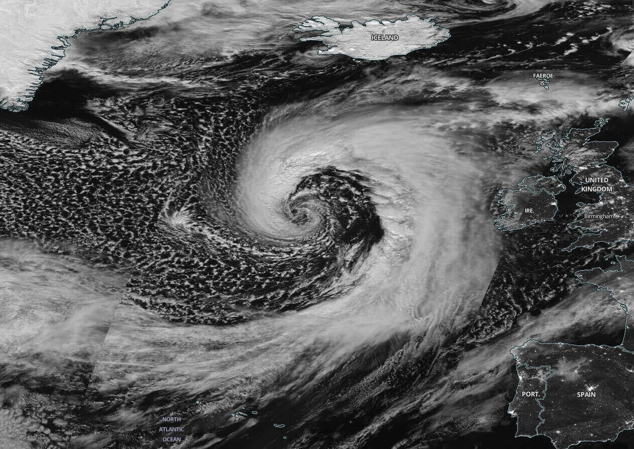
The water vapor satellite this weekend indicated it is a seriously large extratropical storm.
The above image reveals a textbook structure of the initial stages for cyclogenesis after the intrusion of much colder, Arctic air mass from the continent into the Atlantic ocean. A huge comma cloud is seen taking place near a rapidly deepening low, dragging warm air mass towards western Europe.
Although the system’s track and the most intense winds seem to be just a shy west of Ireland and Scotland through Sunday night into Monday, wide wind field and major waves will gradually move towards the Faroe Islands and southern Iceland. However, winds and waves will also increase along the far western coasts of Ireland, Northern Ireland, and Scotland as well.
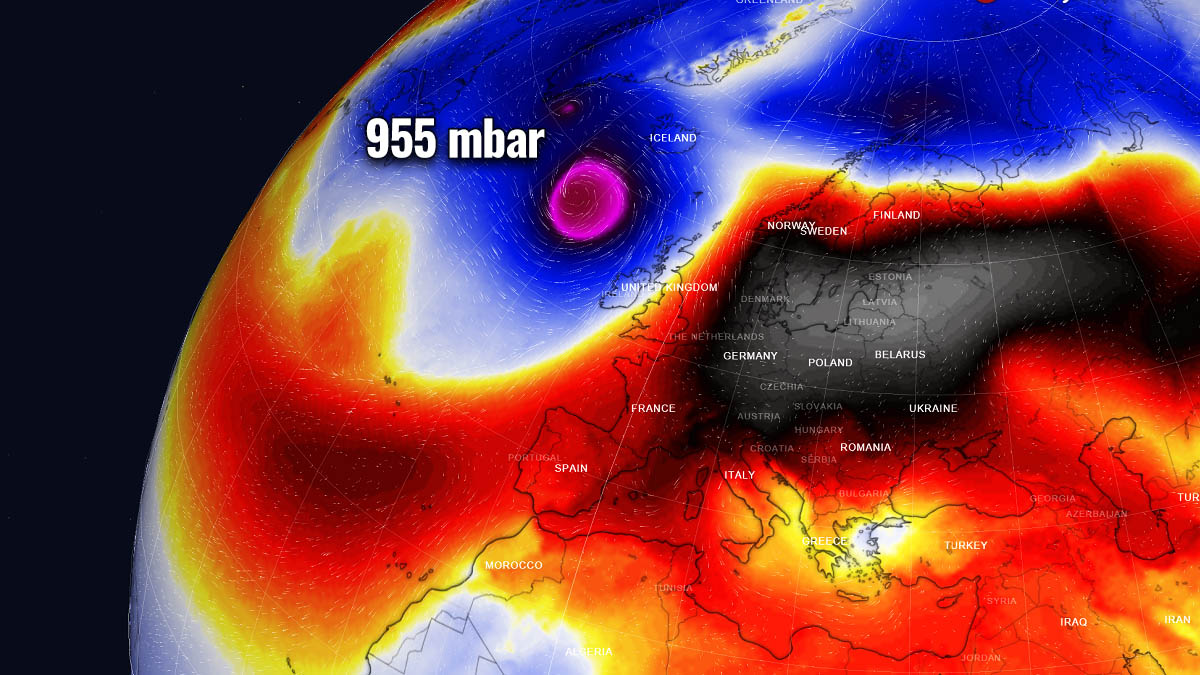
The video overview above hints at the bombogenesis process over the Atlantic, grazing just west of western Europe over the next 48 hours, moving north. The central pressure will reach around 950 mbar at the time cyclone nears Iceland.
If you are wondering why is the North Atlantic so active with all these intense extratropical storms this year, we have a reason behind it. The main large-scale feature that triggers these storms is the Polar Vortex above us. It has been particularly intense and active this Winter season 2021/22, with its most robust part generally placed over North America this year. However, the intrusions of Arctic air masses have led to a very progressive weather pattern in the Atlantic this month.
THE POLAR VORTEX
If we imagine how our Earth’s atmosphere is made, there are six layers that are rounding the planet. Most of the weather that is affecting our lives every day occurs in the lowest two layers. These are known as the troposphere and the stratosphere.
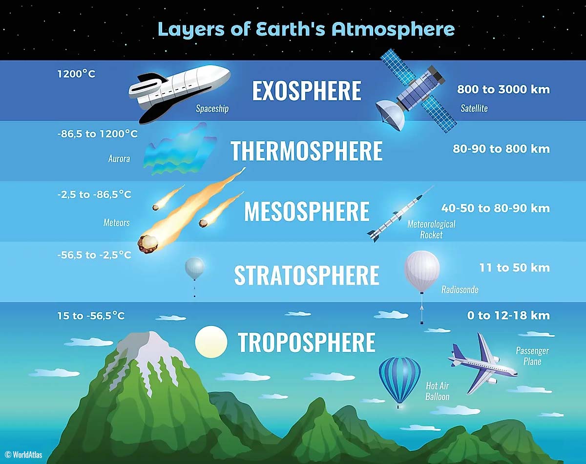
The lowest level is the one where we live, this is the troposphere and is sitting on the Earth’s surface. All the weather changes we encounter take place in this layer. The troposphere layer is around 12 km thick, extending from the surface up in the sky. Its depth is variable between 8 km to almost 20 km, depending on where you live. The troposphere layer is the deepest above the equatorial region, and it gets much thicker above the North and South poles.
Right above the troposphere, a much deeper level is known as the stratosphere layer. The stratosphere is 10-50 km thick and has its air also very dry. This layer also contains a well-known protective layer. The Ozone layer is the one that has a vital role in the protection of our planet’s life against the impacts from the Sun.

The stratosphere has one important feature, it triggers all the weather dynamics we encounter. It is the Polar Vortex. This vortex is an enormous, 3D ring of very intense winds grazing through the sky high above our heads. Polar Vortex surrounds both the North and South poles, moving through the air at about 20-50 km above us.
Both the troposphere and the stratosphere layers are important for the climate we live in, as the Polar Vortex actually covers most of the bottom half of our atmosphere. It extends from the middle of Earth’s troposphere up into the stratosphere layer and has the main effect on the winter weather. The high and mid-latitudes across North America, Europe, and Asia, and indeed the Pacific and Atlantic oceans are all experiencing its force.

The Polar Vortex is the strongest during the winter months in both the Northern and the Southern hemispheres and generally weakens when Spring Season arrives.
Although the Polar Vortex spins very high above our heads, it remains directly connected to the lower part of the atmosphere, with our troposphere. It gives our daily weather a shape in many ways, as it works like one large hemispheric circulation. And all the dynamic systems we have seen this winter have been triggered with the activity of the Polar Vortex above.
How the Polar Vortex actually forms?
Every year as the calendar turns into autumn months, the regions near the North Pole begin to receive much less sunlight. This way it leads to the cooling over the polar regions and as a result, polar nights occur for several months, with days without any sunlight following.
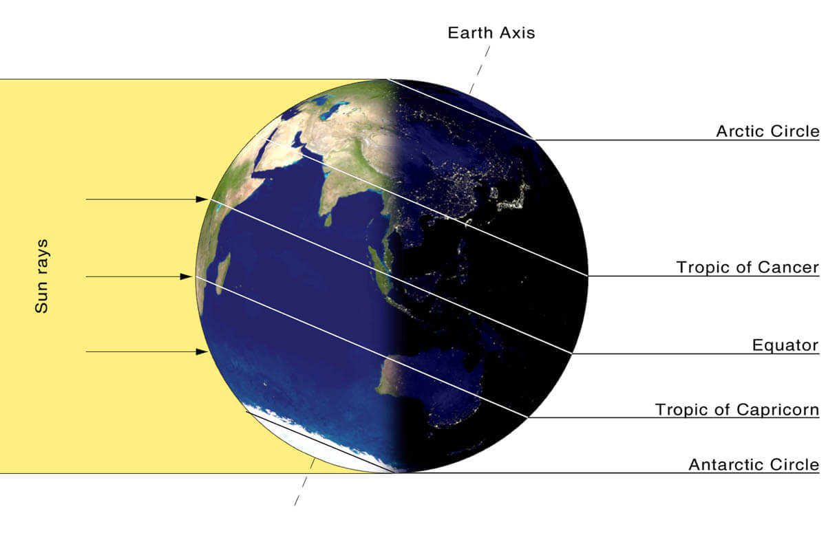
As the polar temperatures are gradually dropping, the atmosphere layers farther south are still relatively warm as they continue to receive more energy from the Sun. So the layers towards the equatorial regions in the south are still much warmer compared to the areas farther north near the Pole. This creates a high-temperature contrast between them.
The other effect of the poles getting cooler towards the end of autumn is that it also translates into lowering the surface pressure. Actually, a pretty similar process happens in the stratosphere layer above, so the temperature difference between the North pole and the equatorial areas increases with time. Thus it generates a large low-pressure cyclonic circulation across the polar stratosphere. This is the Polar Vortex.

Putting all these puzzle pieces together, the Polar Vortex is behaving like a very large and deep cyclone in the atmosphere. It covers the whole North Pole region, extending far south to the regions in the mid-latitudes. Note that it happens the same also in the southern hemisphere during their winter.
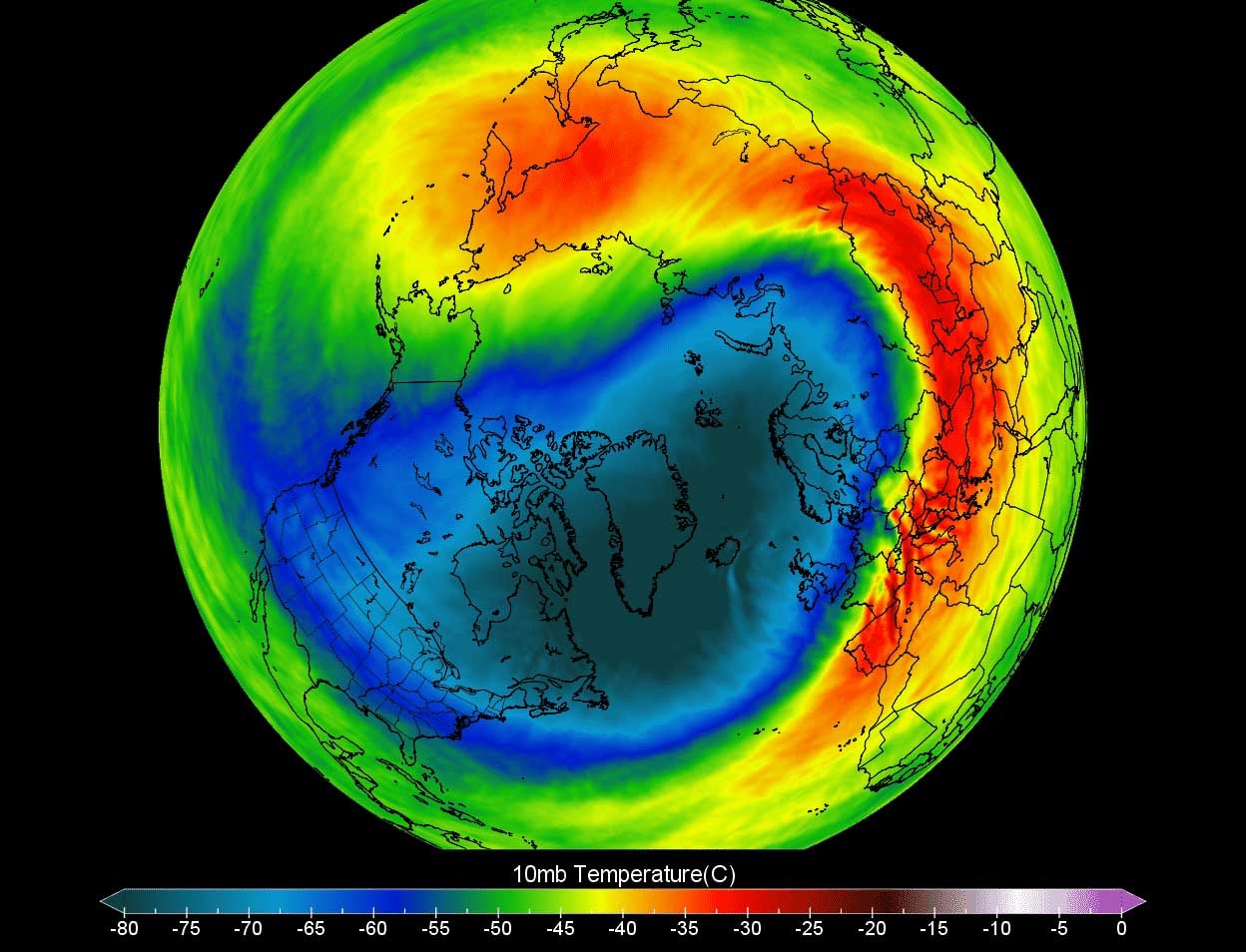
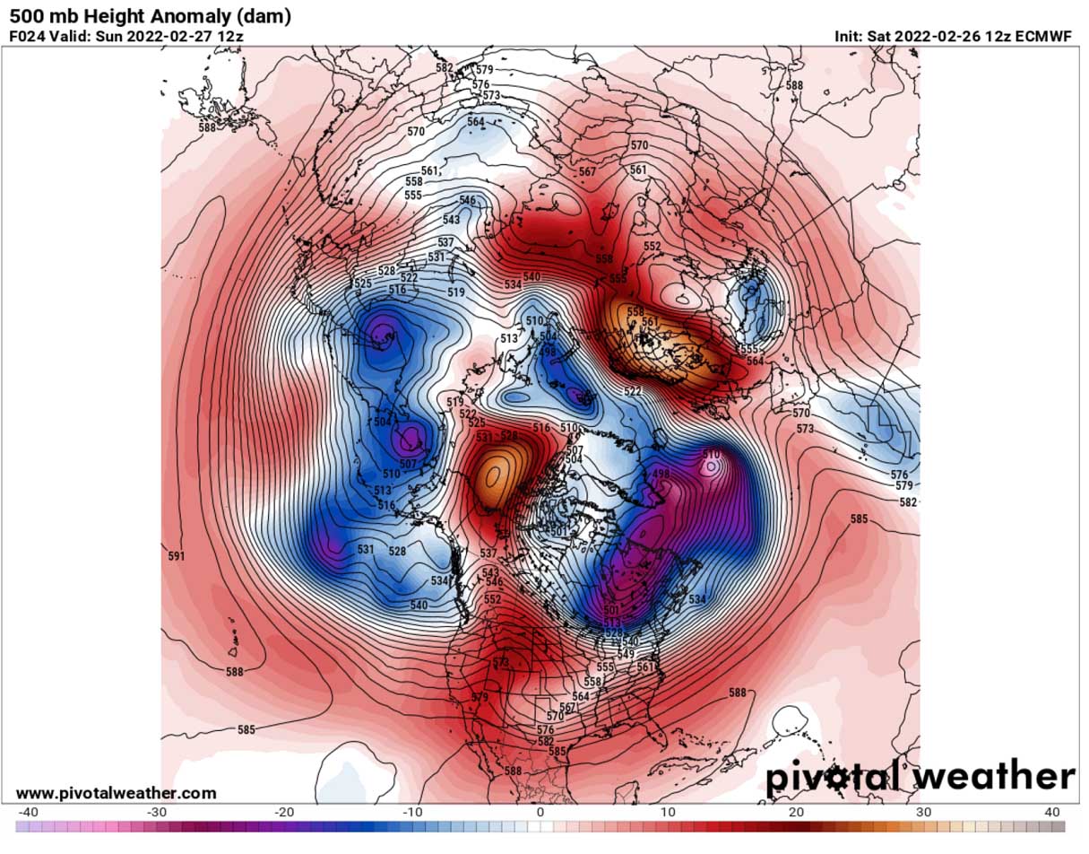
The chart above hints at a very typical example of the Polar Vortex set above us, representing the pressure at around 30 km (18 miles) altitude which is near the top of the stratosphere layer during the winter season.
As we found, the unusually active Polar Vortex in Winter season 2021/22 is the main trigger behind all the winter cold outbreaks in North America and now also in the North Atlantic this month. With the remaining huge reservoir of cold, Arctic air shifting from Canada towards the Atlantic, it triggers more dangerous extratropical storms towards western Europe.
A combination of fresh intrusion of Arctic cold air under the lobe of the Polar Vortex against the warmer and moist air in the Atlantic leads to this new violent bomb cyclone, heading for northwestern Europe Sunday night into Monday.
WHAT A BOMB CYCLONE OR BOMBOGENESIS MEAN?
The pressure change this Sunday is meeting the typical criteria that mean the system will be easily classified as a bomb cyclone. This means that the surface cyclone is rapidly intensifying, with its central pressure falling very fast (or even extremely fast for some time).
These are the systems when you will hear wording explosive cyclogenesis (also known as bombogenesis) as we face the rapid deepening of the barometric pressure of a developing extratropical low in the North Atlantic.

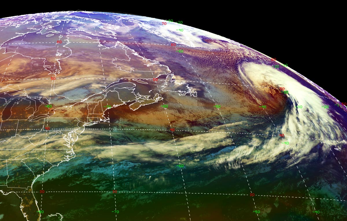
Generally speaking, a central pressure of a low must fall for at least 24 millibars within 24 hours that meet the criteria to be classified as a bomb cyclone. It is purely a non-tropical cyclonic system, also known as an extratropical cyclone that develops rapidly from a low-pressure system. A typical example of such a bomb cyclone is seen on the satellite picture above, a classic Nor’Easter bomb storm along the U.S. East Coast.
The extratropical storms in the North Atlantic can grow very large in its size, usually dominating a large portion of the ocean. Due to the Coriolis force effect, the general movement of these systems in the Northern Hemisphere is towards the northeast. The huge size of these lows produces severe to extremely severe, hurricane-force and damaging winds. Also generating massive sea waves, coastal floods, and beach erosions.

These systems are very similar to a classic extratropical low, as a bomb cyclone is fueled by variations in the temperature. The interaction of the warmer air from the equatorial regions with the much colder temperatures from the Arctic region happens. These processes are also occurring vertically throughout the atmosphere.
These types of Atlantic lows are, despite appearing like tropical cyclones by the look at the satellite imagery, they are very different from the systems we observe during the hurricane season. Hurricanes have their energy source from extremely warm sea surface temperatures found only in the tropical region.

We are monitoring and tracking these systems with annual statistics, as the east coasts of the North American continent are known as the perfect breeding grounds for these types of cyclones before they continue further into the Atlantic. These extratropical storms often bring damaging winter storms to portions of Canada and the Northeast United States, but often continue into the Atlantic and Europe as violent storms, being named by UK, Irish, or Portugal Met Offices.
The massive interaction of Arctic cold continental air mass from Canada with the warm, moist oceanic tropical air near the Gulf Stream in the Atlantic provides tons of energy for a cyclone to explosively develop over the warmer waters.
We will encounter bomb cyclones during the winter months in the North Atlantic, although these cyclones can actually occur all year round. On average every year, there are 60-70 bombs formations on Earth, About 50 of them are found in the Northern Hemisphere, from the east coasts of the U.S. and over the Atlantic.
Let’s now focus on the ongoing system. We will take a deeper look at the effects of this cyclone as the bombogenesis is still underway until Monday morning this coming week.
POLAR VORTEX DRAGS NEW STORM NEAR WESTERN EUROPE SUNDAY NIGHT
The NOAA Ocean Prediction Center (OPC) analysis on Saturday, when the system began its rapid intensification, indicated how quickly hurricane-force winds were developing. The central pressure dropped for about 25-30 mbar from Saturday noon to Sunday afternoon, while the system continues to the northeast with a trajectory towards Iceland and Faroe Islands.

While this low will, fortunately, be well west of the European land, so its violent, hurricane-force wind gusts to nearly 100 mph will miss Ireland and UK. It will be, however, a major producer of significant waves, partly spreading towards Ireland, Northern Ireland, western Scotland, and the Faroe Islands through Monday.
The satellite image in the visible spectrum reveals the system has grown into a very powerful bomb cyclone, with a textbook appearance of a comma cloud around the core. A cold, maritime air mass is spreading behind the main cold front, together with a swath of drier winds to its south. This is the perfect recipe for violent winds formation.

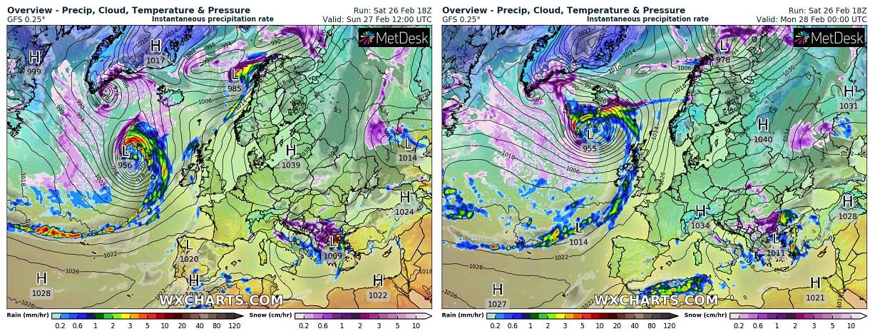
If we look over the general weather pattern across the Atlantic and Europe, we can see a similar picture as it has been through most of February. Deep troughs over the ocean and blocking over the northern part of the European continent. Thus, creating a breeding ground for intense storms to develop.
This is happening due to the deep southern lobe of the Polar Vortex still sitting over eastern Canada, bringing down the plume of Arctic air, maintaining cold intrusions deeper towards the south.

This is a typical thing that happens with such cold intrusions, triggering more Atlantic storms and leading their pressure to rapidly deepen while they move towards Iceland and western Europe. With the blocking high over continental Europe, these systems have a general track across or along with western Europe, affecting Ireland, the UK, and the Faroe Islands most of the time with both winds and rain.
Through Sunday night, there is a pretty huge contrast of deep pressure over the Atlantic against the high-pressure system over Europe. The pressure difference is about 80-85 mbar which creates a strong southerly jet stream in between these large-scale features.
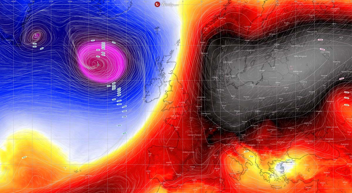
The new storm should continue deepening until late Sunday night, reaching around the low 950s mbar and maturing on Monday morning before reaching Iceland and Faroe Islands. This means that the system is reaching its mature extratropical low phase, becoming a large cyclone and generating a much wider impact of severe winds and major waves.
Notice the pressure gradient becoming very tight to the south and southwest of the center, this is where the most violent winds will develop. Attached below is the weather model sequence of the storm from Sunday into early Monday, passing to the west of Ireland and coming closer to Iceland and Faroe Islands at its maximum force and mature stage.
When the system arrives close to southern Iceland in early Monday morning, heavy snow, severe winds and blizzard conditions will again develop across a large part of the country.
The main cold front associated with this low will move across Ireland and UK through Sunday night, bringing some rain and strong to locally severe winds. With its trajectory farther to the west, wind and rain squalls are mainly limited to northwest Ireland, Northern Ireland, and extreme western Scotland.
Through Monday afternoon, a re-intensification of the front should bring heavy rain across Wales and southwestern England, spreading into central England into the early night hours.
HURRICANE-FORCE WINDS ABOVE 150 KM/H JUST WEST OF IRELAND AND SCOTLAND, MAJOR WAVES EXPECTED
When we have such a deep Atlantic low, with the central pressure in the mid 950 mbar, it brings some pretty violent winds to the south and southeast of the center. with this storm, southerly winds will reach gale force 8 or strong gale force 9 on Irish coastal waters from Valentia to Erris Head to Malin Head in Ireland, similar along far western Scotland.
The highest wind gusts in the core of the most intense swath should reach 140-160 km/h, possibly even close to 180 km/h (100-110 mph). But those will remain off to the west of European coasts.

This large and intense wind field will also generate major sea waves, which will likely reach up to 14 meters near the center and to the northeast of the wind maximum. Those will be gradually spread east-northeast while the system will be advancing towards the north through Sunday night into Monday.
The highest effect should be for the Faroe Islands on Monday afternoon and evening hours.
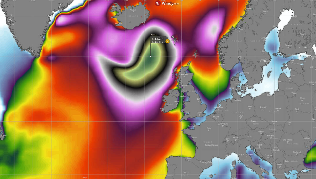
Waves will be of major heights with large swell also across the whole western coast of Scotland, Northern Ireland, and western Ireland. Those could be around 8-10 meters as well, causing some damage to the coastal areas and beach erosion.
TEXTBOOK WARM SECLUSION APPEARANCE IN THIS CYCLONE
Ahead of this continuous active weather pattern across the North Atlantic, a much warmer air mass is again spreading into western and southwestern Europe. Meanwhile, in the wake of this new deep Atlantic low, the northwesterly winds are bringing more Arctic cold air mass into the Northwest Atlantic from Canada and the Labrador Sea region.
This clash of air masses develops a pretty didactic fluid dynamics presentation on the chart, we can see how the large-scale processes are nicely working together while the lobes of the Polar Vortex above trigger weather systems across this side of the northern hemisphere.

The huge temperature contrast image above is a pretty textbook example when it comes to the violent extratropical storms and bomb cyclones in the Atlantic. Extremely cold Arctic air spreads across eastern Canada, with frigid low temperatures advecting into the northwestern Atlantic.
Farther east, the violent force of the exploding extratropical low does the counter effect. A strong warm advection of subtropical air mass will be advected very far north again, rounding the center low with a classic comma shape also seen on the temperature map. This process is better known as warm seclusion, defining that a mature phase of the extratropical low lifecycle is near.
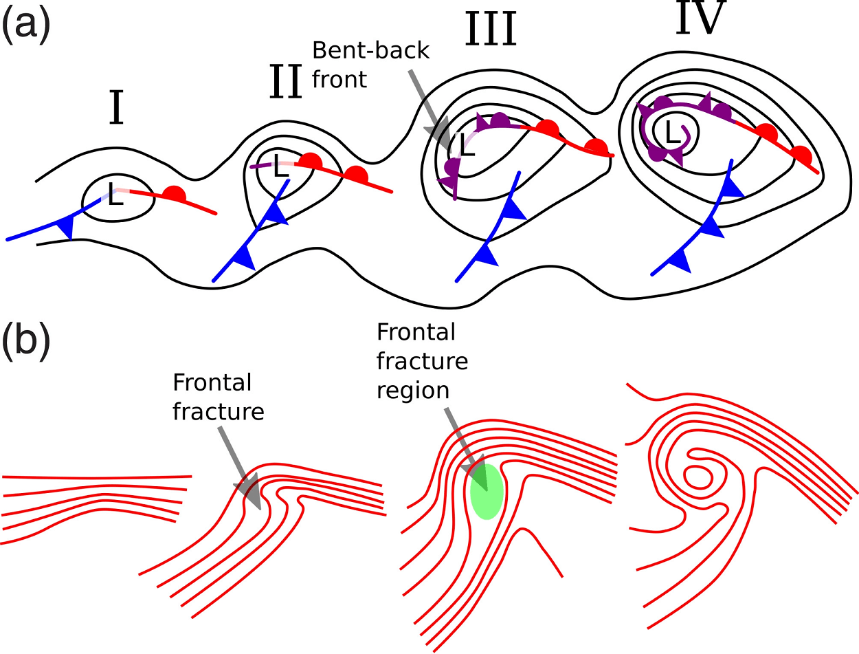
Warm seclusion could have cloud-free and eye-like features at their center, visible on the satellite imagery. Sometimes these can be reminiscent of tropical cyclones. The seclusion indicates that the system’s warm-core center is surrounded by hurricane-force winds, along the bent-back warm front. After the warm seclusion process is finished, the mature stage of a cyclone is in mature mode. Then, a system starts its decaying process and system intensification is completed.
These kinds of bombogenesis systems and weather patterns over the North Atlantic are actually quite classic during winter months, following after strong Arctic outbreaks from Canadian Arctic and Greenland, penetrating onto the much warmer waters farther south. The warm-seclusion Atlantic storms normally produce violent winds and waves, often even particularly violent with hurricane-force speeds in a very narrow area to the south-southwest of the cyclone’s core.
The main driving factor to force these violent winds is known as the sting jet wind maximum. It forms inside the cloud head into the frontal‐fracture region of a Shapiro-Keyser cyclone.
WHAT IS A STING JET WIND MAXIMUM
With the devastating Storm Eunice in western Europe 10 days ago, the meteorological phenomenon that is blamed to produce violent (hurricane-force), and destructive winds are known as a sting jet. This swath of particularly intense winds is often leading to peak wind gusts well above 150 km/h, sometimes those even surpass the 200 km/h, causing severe damage.
A Sting jet is a relatively narrow zone of very powerful winds, originating from inside the mid-tropospheric cloud head within the explosive cyclogenesis or a bomb cyclone in the Atlantic.
By definition, a textbook extratropical cyclone has two frontal zones, the warm front, and the cold front following it. A strong flow of cold air mass develops into the cyclone ahead of the warm front, known as the cold conveyor belt. While behind the main cold front, a much cooler and also drier air mass, very often originating from the Arctic region, flows into the cyclone’s core. Thus, forming a well-defined dry intrusion towards the center of a deepening cyclone, typically rounding the low, emerging from the southwest direction.
The cold conveyor belt brings cold and moist air in general, spreading towards the center of the extratropical storm, together with precipitation such as rain and snow. Meanwhile, the dry intrusion delivers cooler and also very dry air into the cyclone. With the precipitation falling from the cold conveyor belt into the dry air in the dry intrusion streak, droplets are quickly evaporating and leading to further cooling of the air mass. This is a process known as evaporative cooling.
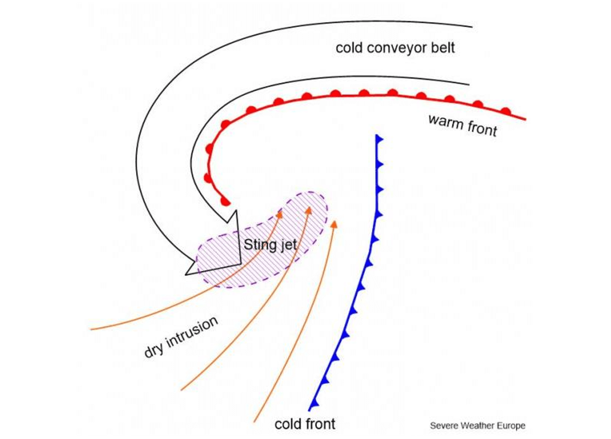
Finally, as the strong winds jet descends towards the surface, those are intensifying more as the air is drying out. So winds are literally grazing and evaporating the layers of air on the nose of this descending jet. Thus, creating a clear path through the precipitation with the evaporative cooling also leads to the air becoming much denser within the jet. This causes the acceleration of the downward momentum or, in other words, winds are pushed down with higher force towards the tip of the cloud head when it wraps around the cyclone dead center.
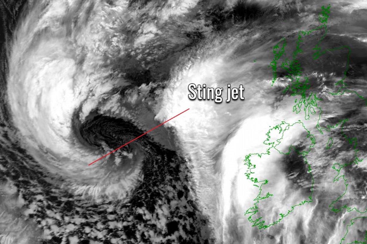
These processes with the sting jet are occurring at altitudes of about 3-4 km above sea level surface and often lead to extremely severe wind gusts. The peak gusts are easily exceeding 90-100 mph (150-160 km/h) or evening stronger than 125 mph (200 km/h) with the most intense extratropical cyclones. Once the sting jet is fully developed, this wind maximum is fairly easily recognizable as the cloud, hooked just like a scorpion’s tail. This gives this dangerous wind region its famous name.
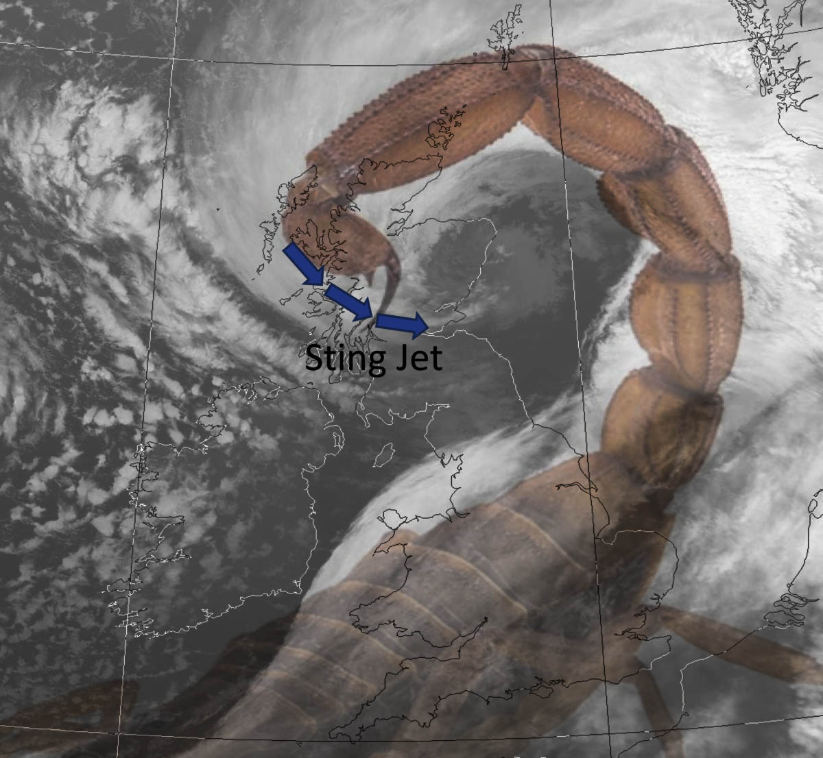
The composite satellite image above hints us how the shape of a textbook cyclone with a sting jet really looks like a scorpion’s tail. Pretty fascinating feature to say at least. A sting jet usually affects only a small region of about 100-200 km across and is compared to the size of the parent large bomb cyclone rather narrow. It usually lasts only for several hours, but when it spreads across the land areas, destructive winds normally occur. This was the case with Eunice.

When we see storms developing so explosively over the Atlantic, we can expect their typical satellite appearance of the banded cloud heads (comma cloud) associated with any type of these bomb cyclones also containing sting jets. As we saw above, the cloud head is strongly curved into the cyclone from where the most intense winds blast towards the surface.
Note, that these cloud bands on the edge of the comma cloud disappear quite sharply on the jet nose due to the effect of evaporation in the dry air of the dry intrusion.
Images used in this article were provided by Windy, Wxcharts, and Pivotalweather.