A powerful and long-lasting heatwave has developed over south-central Europe and is forecast to peak this week. Thanks to an extensive heat dome parked over the continent, locally scorching heat will surpass 40 °C again. Weather model trends indicate that another significant severe weather period could follow into the next weekend, with more flooding potential for the northern Mediterranean.
Temperatures have warmed significantly in the last few days due to a warm plume expansion associated with the strong upper high from northwestern Africa and the Iberian peninsula. This heat is forecast to intensify in the following days.
It will bring more scorching temperatures to Spain, Portugal, France, Italy, and most of the Balkan peninsula. Temperatures will push back into close to 45 °C in parts of the Iberian peninsula, low 40s in southern France and North-cental Italy, and into high 30s to low 40s across south-central Balkans.
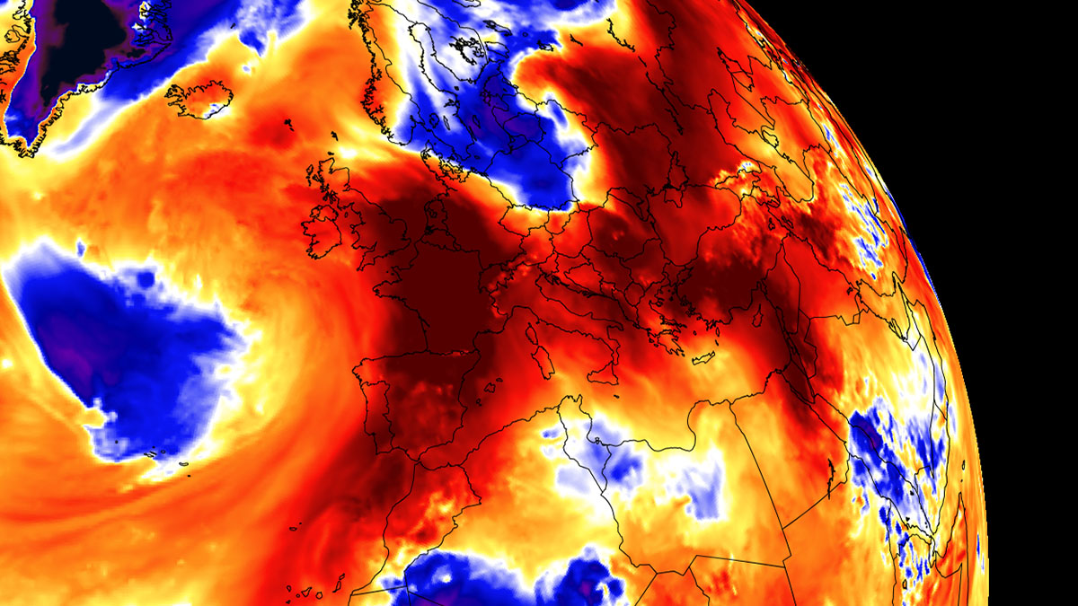
As discussed in our latest update on this large-scale event recently, a plume of hot air mass first spread into Spain and Portugal early last week, and temperatures are further increasing across France, Italy, and central Europe.
Extreme heat, still ongoing over Turkey and the Middle East, is expected to continue for another week. Temperatures were peaking into the upper 40s and low 50s for days.
These long-lasting events are associated with a large-scale feature known as the heat dome, which has dominated Europe’s general weather pattern since mid-August. This feature intensifies further and is forecast to peak the powerful heatwave in the following days.
WHAT IS A HEAT DOME, AND WHY IT BRINGS EXTREME HEAT?
A heat dome is the primary cause of this powerful heatwave across Europe this late summer. This term was a large-scale event when significant heatwave events occurred in the past, in Europe or the United States, and Canada. Currently, this feature is dominating the United States and Europe, resulting in extreme, scorching heat underneath.
Usually, the heat dome is the main, dominant feature of summer weather patterns on both continents. It helps extremely high temperatures to develop; here is why.
The upper-level ridge pattern, or very warm air mass in the higher altitudes, also known as the Upper High (or blocking High), usually forms the heat dome. This weather pattern brings high, sometimes record-challenging temperatures for the region below.
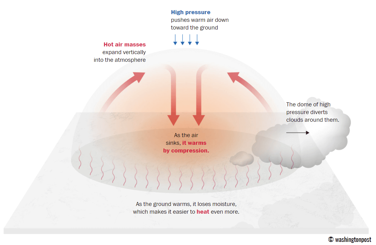
This specific term is used when a broad area of high-pressure parks over a large portion of the continent. It normally stays there for several consecutive days or even weeks.
The heat dome works like a lid on a pot. The extensive dome of heat results in the trapping of a particularly warm air mass at all levels underneath, with sinking layers toward the ground. Therefore, the air mass becomes anomalously warm at the lowest elevations, challenging both night-time and daytime temperature records.
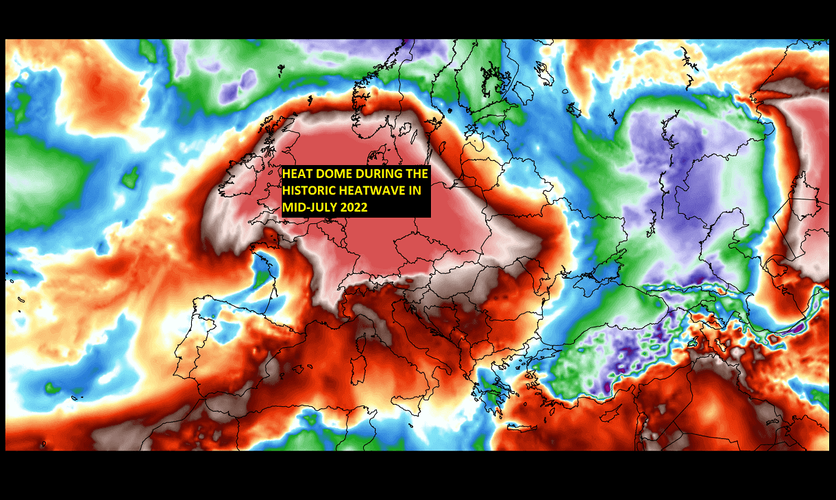
Heat dome creates stable weather and often arid air mass with minimal chances for precipitation or even clouds—the sinking air parcels in the center of the heat dome result in rising temperatures. The following image is an example of such an event from last year’s summer, which brought extreme heat over Europe in July 2022.
Typically, warmer and drier weather also significantly enhances wildfire threat, particularly due to developing drought or worsening the ongoing, pre-existing, arid conditions. Heat dome is often also to blame for being responsible for deadly heatwaves worldwide.
The nighttime low, daily average, and maximum temperatures under the heat dome are typically above average. When the dome is particularly strong, it could challenge or break existing historical records. Mainly if this feature develops during early summer or early autumn/fall.
Recently, such heat domes brought record temperatures in Italy and Spain in July 2023, and, most recently, the scorching hot temperatures in Valencia, Spain, and Turkey this month.
HEATWAVE BREAKS NIGHTTIME LOW TEMPERATURES ACROSS WESTERN EUROPE
The effect of a significant warm air mass in the low and mid-levels of the atmosphere is not only resulting in very high daytime temperatures but also bringing new nighttime low-temperature records across parts of western Europe.
On Saturday, France set several new nighttime low-temperature records.
- +21.9 °C in Amilly
- +21.8 °C in Sommesous
- +21.7 °C in Amiens
- +21.5 °C in Beauvais
- +20.1 °C in Charleville-Mézières
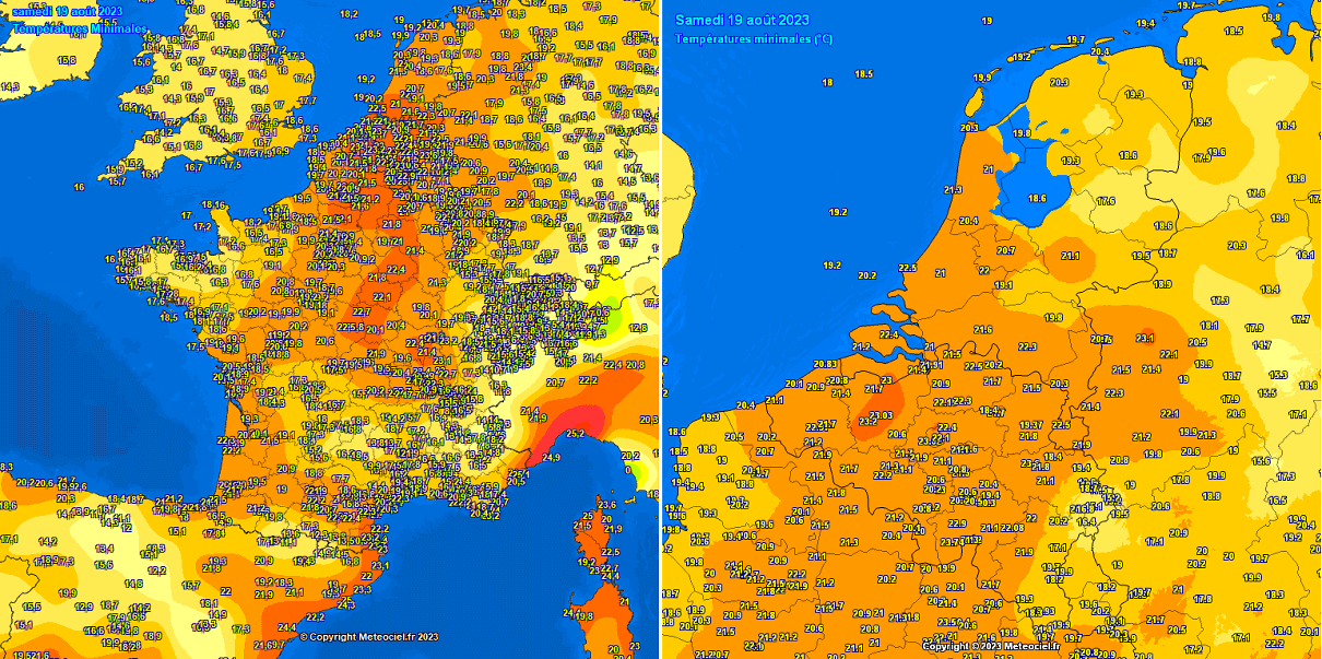
The lowest temperature at the Netherlands’ main weather station De Bilt did not fall below +21.7 ⁰C. If officially confirmed by the meteorological service, this would become the Netherlands’ warmest August night on record.
The lowest temperature in parts of western Belgium and Germany were also in the 21 to 23 °C range. This is a significantly warm nighttime temperature for the region.
The potential exists that temperatures at night could be even higher in the following days, also across Italy and central Europe, as the heatwave strengthens.
INTENSIFYING HEATWAVE OVER EUROPE PEAKS BENEATH A LARGE HEAT DOME
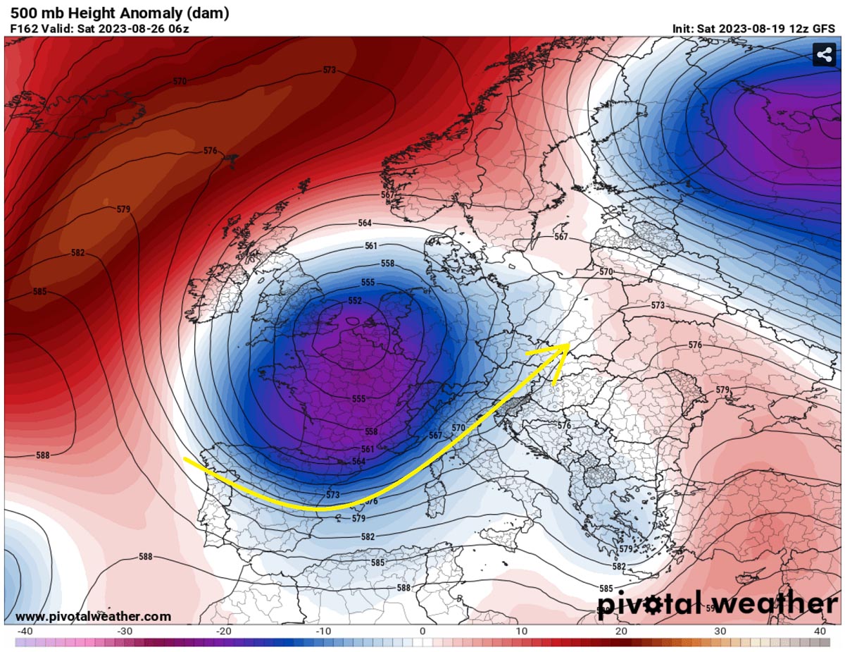
In the following days, the general weather situation in Europe reveals that a high-pressure system is strengthening beneath the extensive heat dome. This suggests that a long-lasting period of more stable and extremely warm weather will continue into the new week.
The blocking High dominates much of the European continent, centered over central Europe. It rejects any frontal systems of intrusions of colder air mass from the Atlantic. This is an extremely high geopotential height on the 500 mbar anomaly chart, as seen in the ECMWF model. This weekend, 0 °C isotherm was reported at near 5000 m ASL altitude.
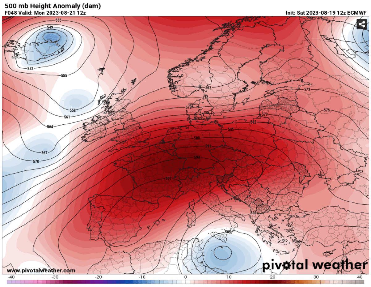
The obvious result is an increase in the heat underneath due to sinking air mass in the core of the ridge aloft.
With the southwesterly flow from northwestern Africa, a warm plume has pushed temperatures very high again. The air mass will be further warming with plumes advecting warmer air mass in the following days as the High gradually spreads east and north with time this week.
The warmest and most significantly anomalous air mass will be over Spain, France, the Mediterranean, and central Europe. Later this week, the heatwave will also push temperatures into extreme values over the Balkan peninsula, including Greece and Turkey.
A warm air mass will continue and extend nearly the next weekend when a sharp change in the weather pattern is shaping up on the weather models. An intrusion of the deep trough and a more progressive weather pattern will develop in western Europe, while heatwave will remain over south and southeast Europe. Until then, temperatures well above-normal for late August will remain.
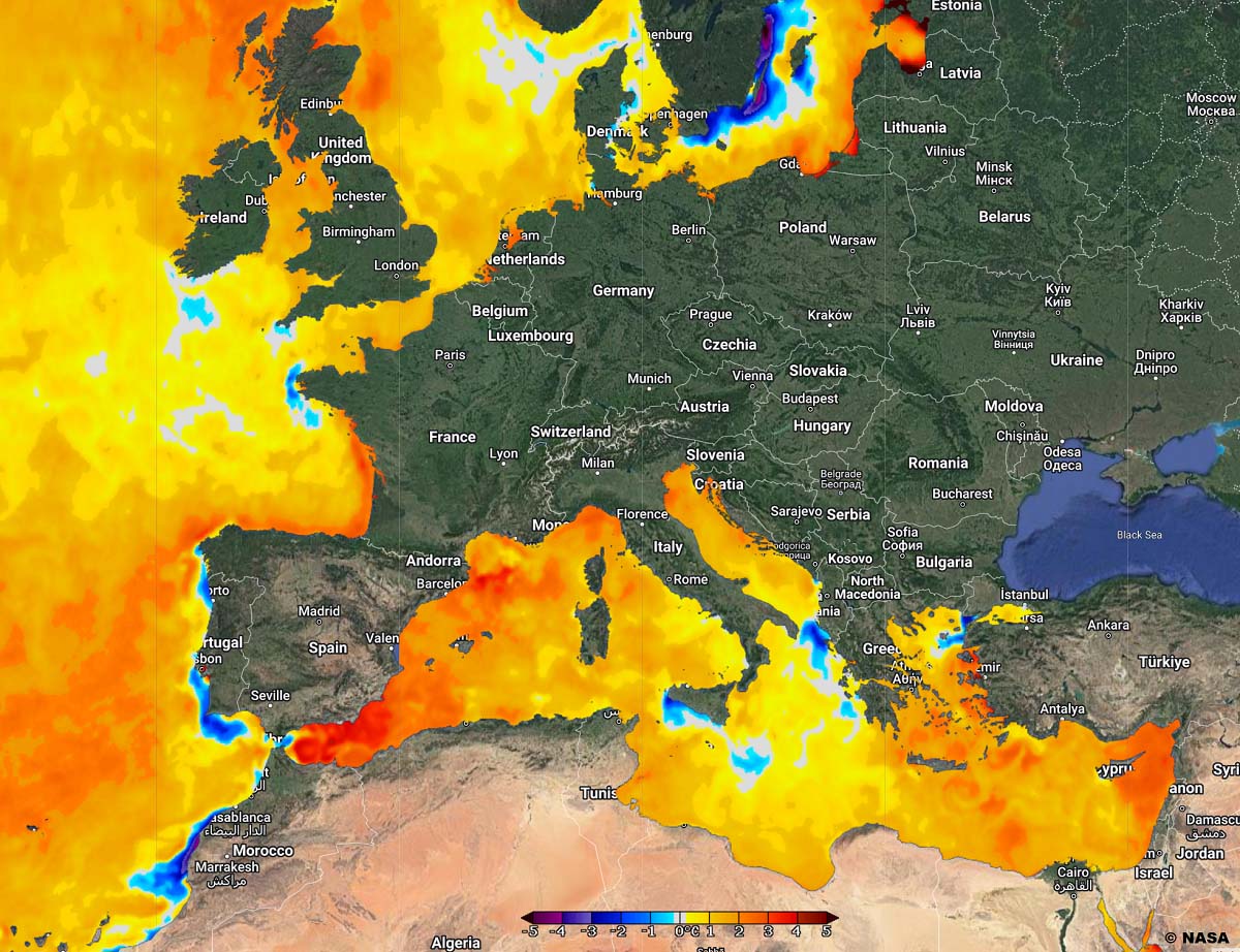
Attached below is Wednesday’s 2 meters temperature anomaly over Europe. We can see how significantly anomalous the air mass will be from Spain and Portugal to France, southern Germany, northern Italy, and the Alpine region. The highest anomaly is seen over Iberia and southern France.
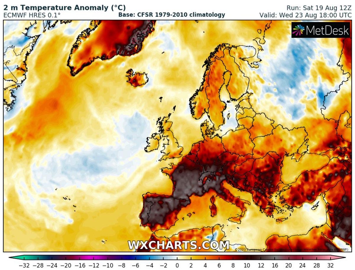
Europe will remain in much warmer temperatures than normal in the coming days this week. Mid-week days from Tuesday through Thursday will push temperatures into extreme values for this late period of August.
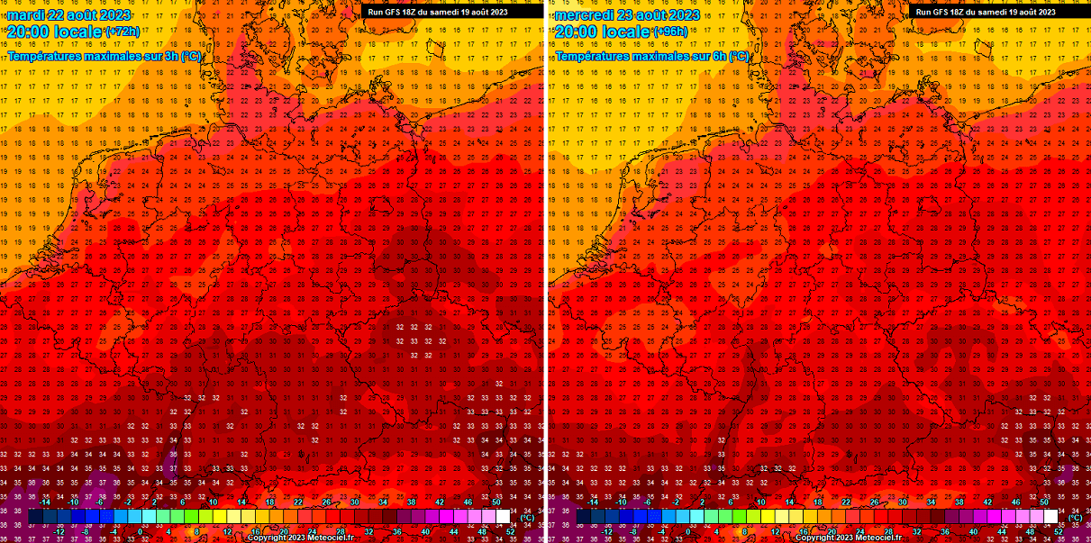
SCORCHING HEAT RETURNS TO SPAIN AND PORTUGAL, FORECAST TO PEAK CLOSE TO +45 °C AGAIN
As discussed above, the strengthening heat dome aloft increases heatwave. While the recent days had peak temperatures staying below the 40s, the gradual temperature increase will start on Monday. The conditions combine for another extreme, scorching heatwave for the Iberian peninsula.
The attached charts are below for Monday and Wednesday this week. It indicates how potentially extreme temperatures could develop once again. For late August, this is extreme heat even for Spain and Portugal, both known to have high temperatures in summer.

On Monday, temperatures are forecast to rise across southern Portugal and southwestern Spain significantly. Both countries could peak at 42-44 °C in the afternoon hours. Also, the rest of the peninsula will be locally in the upper 30s to near 40s on Monday.
Similar conditions are expected on Tuesday and Wednesday, or even warmer in some areas, especially in Portugal. The maximum temperatures in Portugal could reach around +44 °C, worsening the ongoing drought and wildfires. Southwestern Spain will again push into 41-43 °C, while the rest peak at a few degrees lower temperatures.
But nonetheless, the heat will be extreme.
HEATWAVE RE-INTENSIFIES INTO SOUTHERN FRANCE; UP TO +42 °C IS FORECAST UNDER THE HEAT DOME
Like the Iberian peninsula, a warm plume will bring much higher temperatures into Western Europe, particularly France. On Monday, temperatures are forecast to climb into the 33-37 °C across central France. Farther north, temperatures are forecast to remain in the mod to upper 20s, in the mid-20s across Benelux and northeast France.

The highest temperatures are forecast across southern France, with peak temperatures ranging from 38 to +42 °C from Monday through Wednesday. Thanks to the high temperatures in the mid-levels, also the higher elevations will experience high daytime values. As well as nighttime lows.
Closed valleys could reach even higher than 42 °C due to downslope very dry winds on the first days of the week.
WARMTH SPREADS ALSO INTO ENGLAND AGAIN, WITH MONDAY AND TUESDAY BEING THE WARMEST OF THE WEEK
The warm plume will reach its peak effect in western Europe until Tuesday, so temperatures will be quite warm also for the UK and Ireland. On Monday, most of south-central England will experience 24 to 26 °C in the afternoon, from 15 to 20°C across the northern parts and over Scotland. Ireland should warm into the low 20s as well.
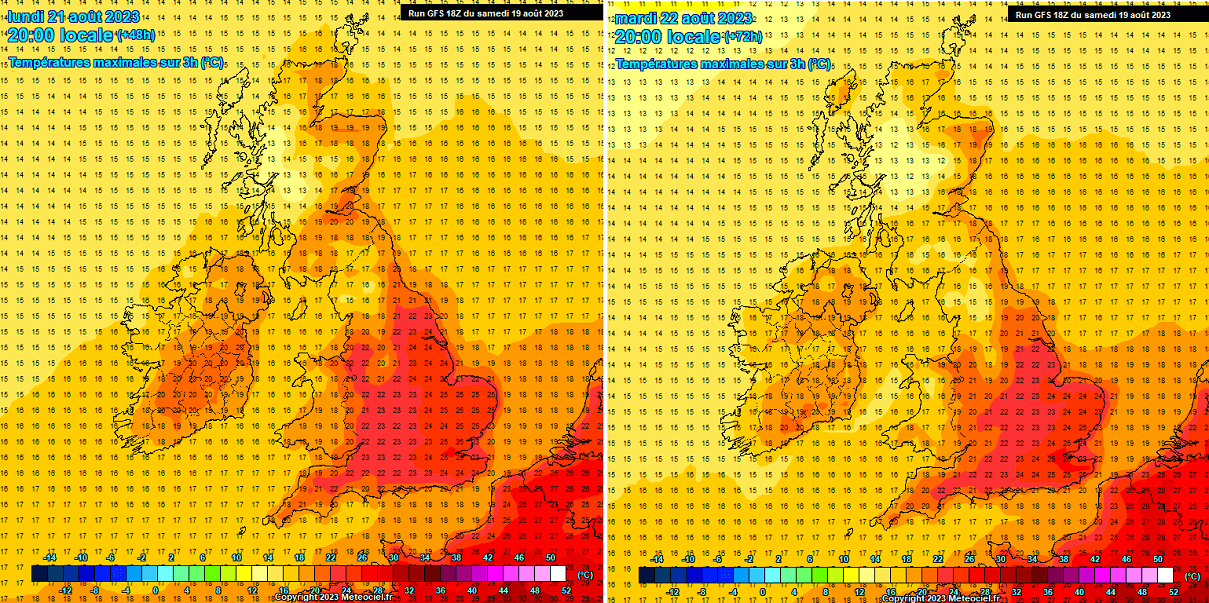
A day after, on Tuesday, a tad lower temperatures are forecast for Scotland and Ireland, but England should remain in the warmth. The highest temperatures should again climb to around 25 °C, or even higher locally across the southeast.
HEAT CONTINUES FOR SOUTHERN PORTIONS OF GERMANY, SPARES THE NORTHERN PARTS FROM THE WORST
The position of the high-pressure system in the early to mid-week will allow temperatures to maintain the low 30s across south-cental Germany. At the same time, areas further north should remain in a cooler air mass.
Peak afternoon temperatures over the valleys in southern Germany will reach 31 to 35 °C in some places. Significantly warmed mid-levels will also contribute to high daily maximum temperatures for the higher altitudes and help the nighttime temperatures not cool below 20s.
EXTREME HEAT SPREADS INTO THE MEDITERRANEAN, ITALY, AND BALKAN PENINSULA THROUGH THE WEEK
An upper High will gradually expand east-northeast throughout the start of the week, allowing temperatures to warm up significantly across the Mediterranean, central Europe, Italy, and the Balkan peninsula. On Monday and Tuesday, the upper-30s are forecast across northern Italy, even higher over the central parts of the country.

With the heat dome reaching its peak strength on Wednesday and Thursday, the mid-levels will become even warmer. Resulting in scorching hot temperatures that are forecast to spread across Italy and north-central Balkan countries on Wednesday.
The potential is high that temperatures will surpass the +40 °C mark again, so excessive heat will return for the lowlands across North and Central Italy. And also for central Balkan plains, e.g., eastern Croatia, southern Hungary, northern Bosnia, and Serbia.
Very high temperatures are also forecast for southern Italy and the Balkans from Tuesday through Thursday, mainly in the 35-39 °C range, and continue or become even warmer towards the next weekend.
A SCORCHING HEATWAVE WILL RETURN TO GREECE AND TURKEY AS THE HEAT DOME SHIFTS EAST LATER THIS WEEK
After a short period of more near-normal temperatures for the southern Balkan countries, temperatures will also significantly increase this week. Thanks to the strengthening heat dome aloft to the north, Greece is forecast to reach around 40 °C again after Tuesday.

Very high temperatures are also forecast for Albania, North Macedonia, and Bulgaria on Tuesday and Wednesday, extending into the late weekdays. Expect peak afternoon temperatures to reach 36-40 °C in many places, possibly even up to 42 °C in the most heat-prone valleys.
Scorching heat will continue over Turkey, with the most significant increase, especially for western Turkey, with Tmax from 40 to 44 °C throughout mid-week days.
THE HEATWAVE IS LIKELY TO END WITH ANOTHER MULTI-DAY SEVERE WEATHER OUTBREAK FOR CENTRAL EUROPE AND NORTHERN MEDITERRANEAN
The current powerful heat dome and heatwave brought much-needed relief after multiple severe weather outbreaks from France, Germany to Italy, and the Balkan peninsula in late July and early August. Giant hail events, severe winds, tornadoes, and extensive flooding are the most striking.
But the medal always has two sides, one is this quite long period of sunny and dry weather. But the other side is becoming a greater concern, here is why.
As we can see from the 500 mbar chart above, the general weather model consensus is a rather good agreement that a big change in the pattern will likely arrive late this week and over the weekend. The main European weather model, ECMWF from Reading, hints at a deep and powerful upper-level trough/low to dig into the European continent.
Since the Sun has a strong heating effect through mid and late August, the land and the Mediterranean Sea have warmed significantly. If sea temperatures sharply declined from their historic record values, they are now warming up back up fast and will continue to do so this week.
With the decaying heat dome ahead of the deep low, the result will be an intense jet-stream wind maximum aloft. In other words, this means that strong wind shear will return. And overspread the overheating land and extremely warm seas.
The above chart represents the temperature anomaly of the seas around Europe. The Mediterranean Sea has already returned to 2-3 °C above normal values, meaning air mass will be much more humid for the upcoming frontal systems late this week.
Note that the warmer the seas, the more moisture is available in the air. And high moisture is the main fuel for thunderstorms. Therefore the potential energy is forecast to push into extreme values again. So, a great combination of high moisture and intense wind shear aloft. Meaning severe weather outbreaks are likely to follow after the heat.
In the chart above, we can see the frontal system with a sharp boundary across central Europe. It separates the heatwave ahead of the frontal zone from the colder air mass in its wake.
How and where the frontal system(s) will strike is yet to be determined, as this is a mid-term outlook, but areas to monitor are from France and Germany to the Alps, Italy, and the Balkans once again.
POTENTIAL FOR TORRENTIAL RAINFALL AND ADDITIONAL FLOODING THREAT COULD RETURN
One of the biggest concerns, especially after devastating flooding events in Italy, Austria, and Slovenia two weeks ago, is the amount of rain that could develop. The first charts undoubtedly are a great concern.
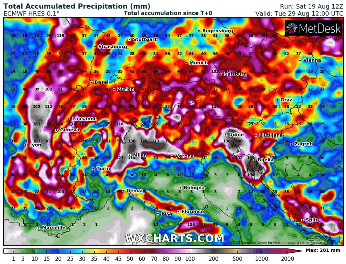
As the attached chart above shows, extreme rainfall amounts (100-300 mm) are forecast for the Alpine region, from southeast France to Switzerland, northern Italy, Austria, and Slovenia. Similar areas are often hit with the most excessive rainfall events.
If such events develop late in September or October, they would be classified as big rain autumn events. However, remember we are still in late August, Mediterranean Sea provides an extreme amount of energy. This means frontal rainfall will combine with thunderstorms and could lead to more torrential rainfall and flooding events, even for the areas severely hit earlier this month.
We will have additional information on the severe weather and flooding potential in a few days when more details from the high-resolution model outputs will be available. One option to check the potential mid-term weather evolution is to use ensemble Meteogram forecasts.
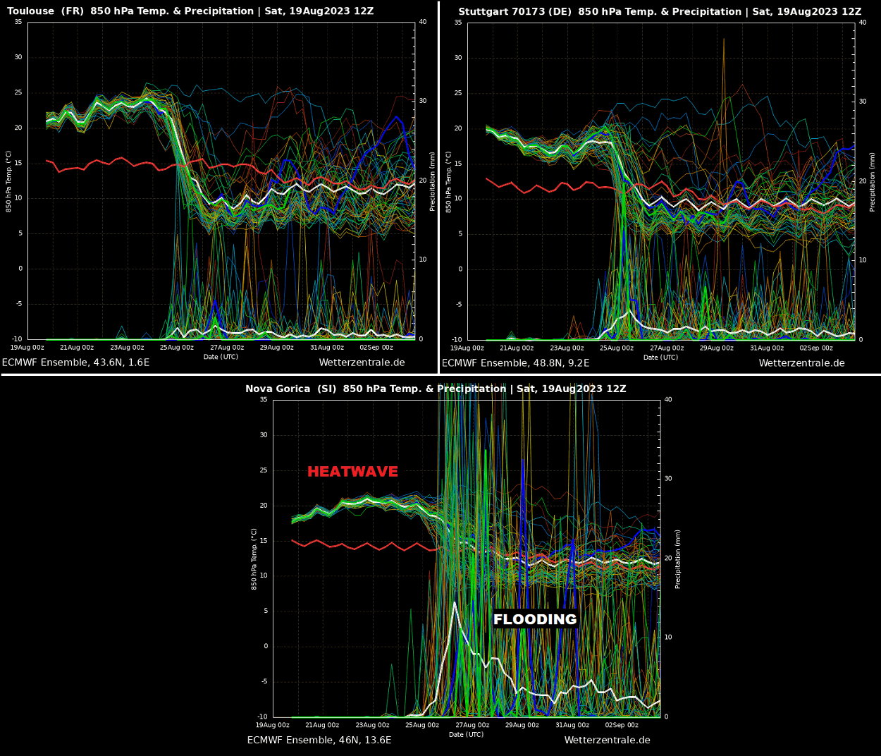
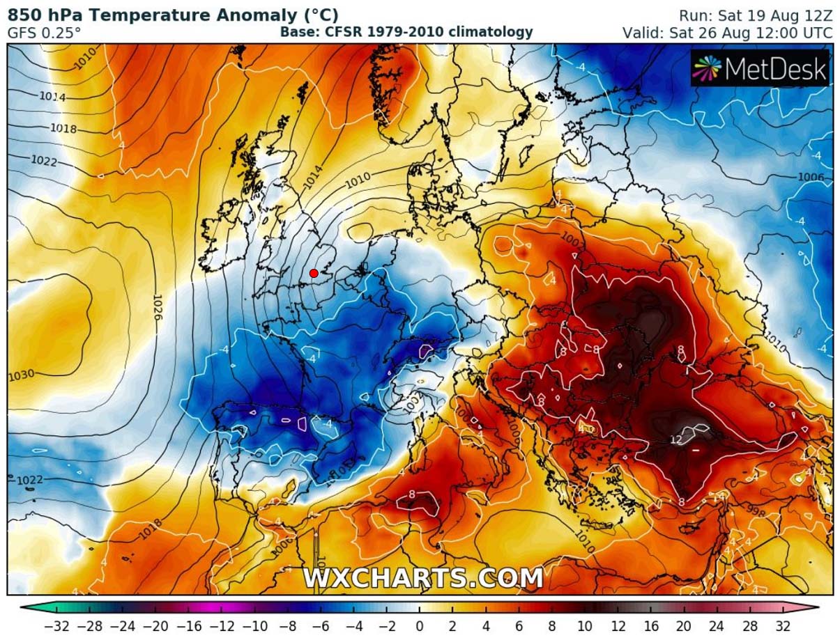
The upper-left image above is for Toulouse, France, where the strongest anomaly will be observed in this heatwave. The upper-right image is for Stuttgart, Germany. And the bottom image is for Nova Gorica, Slovenia.
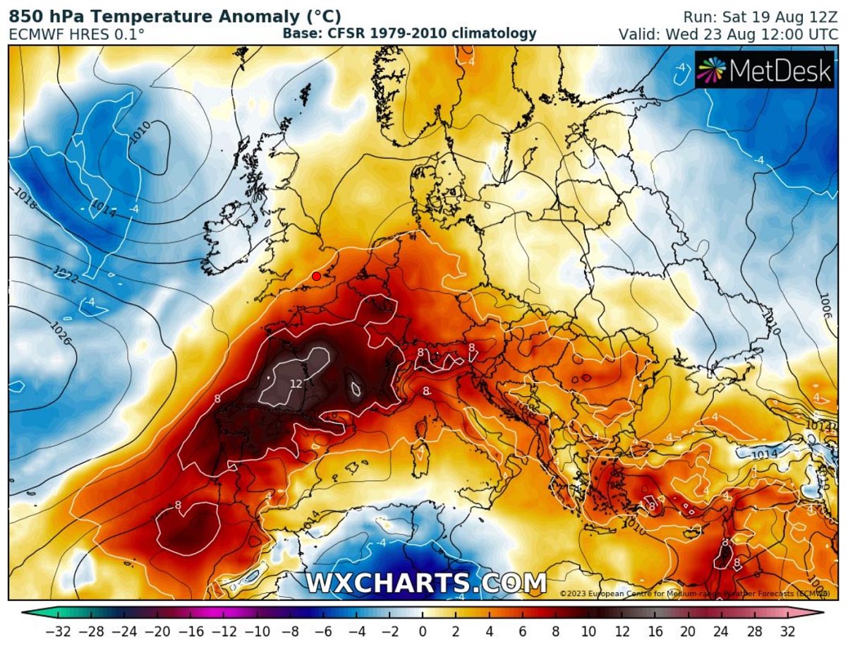
Notice one thing, the significantly anomalous temperature at the 850 mbar level temperatures (approximately 1250m above the ground) is ending around 24/25th August, so late this week. Toulouse has an air mass nearly ten degrees Celsius above normal at this level, and Stuttgart and Nova Gorica are around 5-8 °C above.
A sharp drop in temperature on the Toulouse chart hints a cold front will be rather fast across France. Still, a less steep decline in temperature observed on the Stuttgart or Nova Gorica Meteograms suggests it will extend across a couple of days—especially the latter, so south of the Alps and over the northern Mediterranean.
The Nova Gorica Meteogram also hints at a tremendous amount of rainfall to follow after Friday, which is our greatest concern about the weather’s evolution. Several days of excessive rainfall and increasing potential for widespread flooding once again!
POTENTIAL HEALTH RISKS DURING A HEATWAVE
During large heat dome events in summer and an extended period of hot weather, the temperatures surpassing +35 °C or even above +40 °C, it is physically challenging and presents an enhanced risk for health.
Scorching hot weather, particularly in extended periods – heat waves – is uncomfortable but presents a significant health risk.
Who is most at risk?
Scorching hot weather is uncomfortable to most people, but some are particularly threatened by the very high temperatures we encounter in the summer months:
- elderly people aged over 75 years
- babies, young children
- people with chronic/long-term health conditions, such as diabetes, respiratory disease, circulatory disease
- people who are obese
- people taking certain medicines
- people who work outdoors, in hot/poorly ventilated areas, or engage in physical activity in hot weather
- socially isolated people
- people who are not acclimatized to hot weather, such as tourists from northern countries

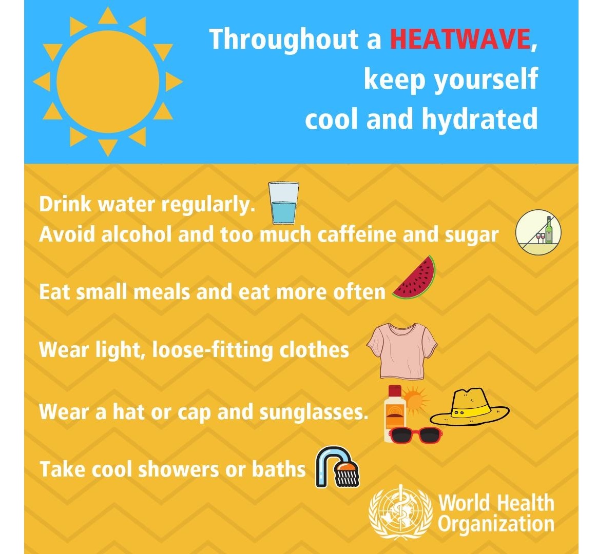
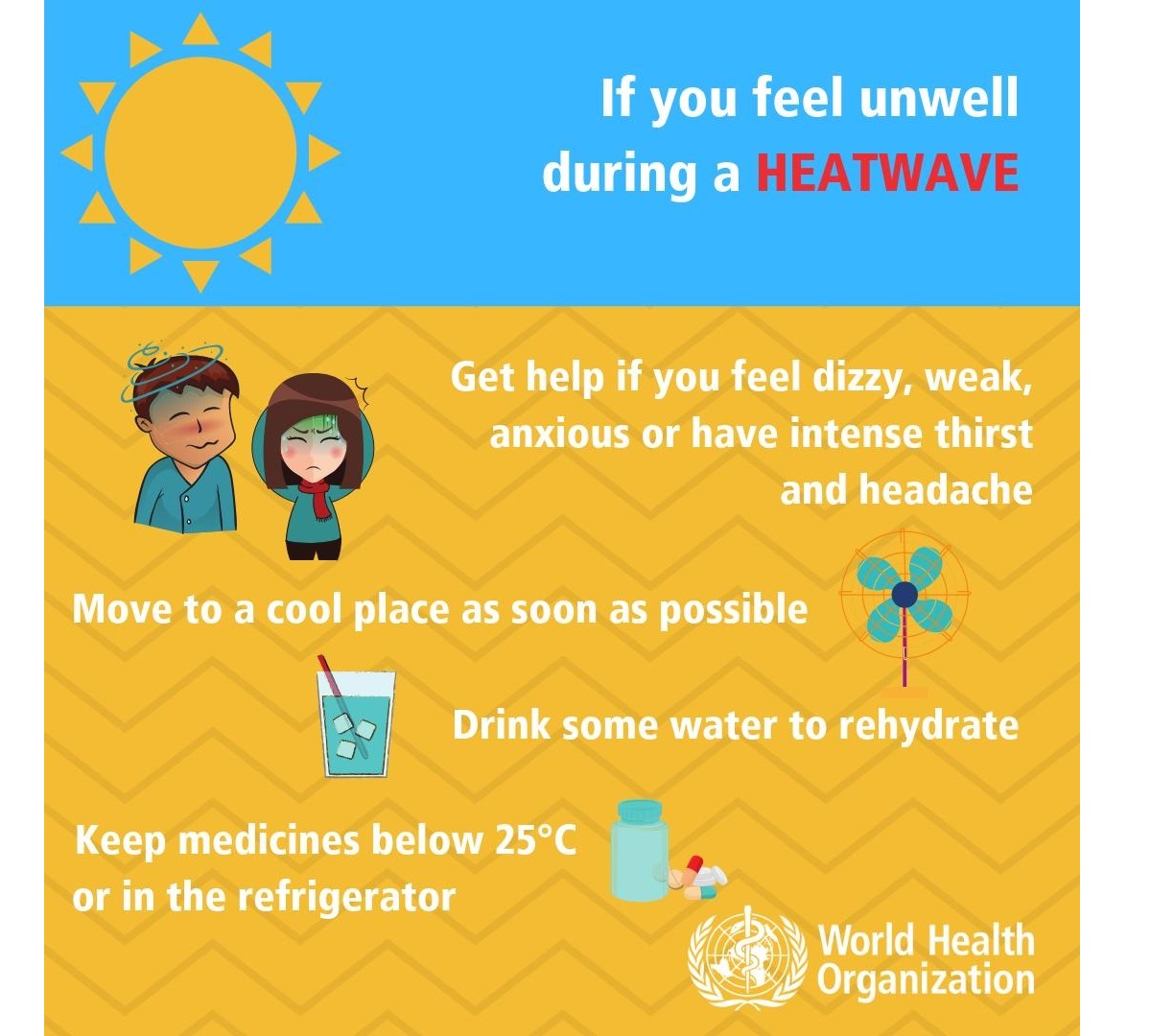
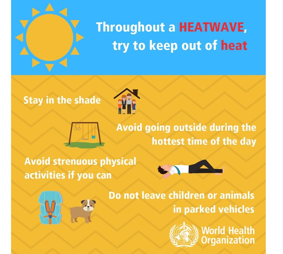
How to stay cool, hydrated, and healthy in hot weather
Staying hydrated is one of the most important things during extreme heat. Consider taking these precautions and measures to stay healthy in scorching weather:
- Drink plenty of water! – human’s body cools through sweating; on a sweltering day, an adult may lose up to several liters of water. Keep drinking water, and avoid drinking alcohol, hot drinks, and drinks with high sugar content, as they can worsen dehydration. A regular intake of water is a good way of preventing dehydration.
- Keep cool – keep your body cool and stay out of the sun if possible. Eat small meals, preferably fruit and salads. Wear light-colored and loose clothing made from natural materials like cotton. Take a cool shower or a cold bath if you feel hot. Also – keep your workspace and living space cool.
If you do not have air conditioning, shut the curtains and blinds during the day. Stay in the coolest room, and avoid using the stove and oven as much as possible. If your home gets too hot, go to a cooler place – a library, shopping center, cinema, or swimming pool.
- Keep your food safe! – keep food that needs refrigeration properly stored! Food spoils much faster at high temperatures, and you may risk food poisoning if the food is not stored correctly.
- If you need to go out in the sun – protect your skin, use proper sunscreen and clothing to avoid sunburns. Cover your head correctly.
- Know your body, and have a plan – ask your doctor if you have any health conditions that may increase the risk of heat-related illness. Call and consult with your doctor if you are feeling unwell. Call emergency help (know the number!) if you feel unwell!
Common heat-related illnesses – symptoms and what to do if it happens
World Health Organization (WHO) considers these symptoms’ descriptions and treatments below as informative only – consult with your doctor for details and professional advice:
Dehydration
Dehydration occurs when the body loses too much water to maintain its normal functions. These symptoms include dizziness, tiredness, irritability, thirst, dark yellow urine, loss of appetite, and fainting. If you encounter dehydration, drink plenty of water or diluted fruit juice. Avoid coffee, alcohol, and sugary drinks. Move to a cooler space to cool off. If you feel unwell, call your doctor or emergency room.
Heat rash
Heat rash is an itchy rash caused by excessive sweating. Move to a cooler, dryer environment, and keep the affected areas dry. Hydrating creams may make the condition worse. Consult with your doctor.
Heat cramps
This happens during strenuous activity when the body sweats and loses water and salt. Heat cramps manifest as muscle pains or spasms. If this happens, stop all activity, move/lie down in a cool place, and raise your legs slightly. Drink water or diluted juice. Have a cool shower or bath, and apply ice packs. Refrain from returning to strenuous activity for several hours. If heat cramps do not subside, seek medical help.
Heat exhaustion
Heat exhaustion is the condition in response to losing excessive amounts of water and salt due to dehydration. Symptoms include heavy sweating, pale skin, fast and weak pulse, fast and shallow breathing, muscle weakness or cramps, tiredness and weakness, dizziness, headache, nausea or vomiting, and fainting.
If heat exhaustion occurs, the body needs to be cooled and rehydrated by moving to a chilled place, lying down, having a cool shower or bath, and placing cool packs under the armpits, groin, or back of the neck. Rehydration should be done by taking small amounts of cool fluids. Medical help is advised if symptoms do not abate within an hour.
Heat stroke
Heat stroke happens when the body temperature reaches 40.5 °C, a severe and life-threatening condition! Immediate first aid in lowering body temperature is critical, and an immediate call for an ambulance! Find more information on heatstroke here.
Stay safe!
Wxcharts, Pivotalweather, and Meteociel provided images used in this article.
See also: