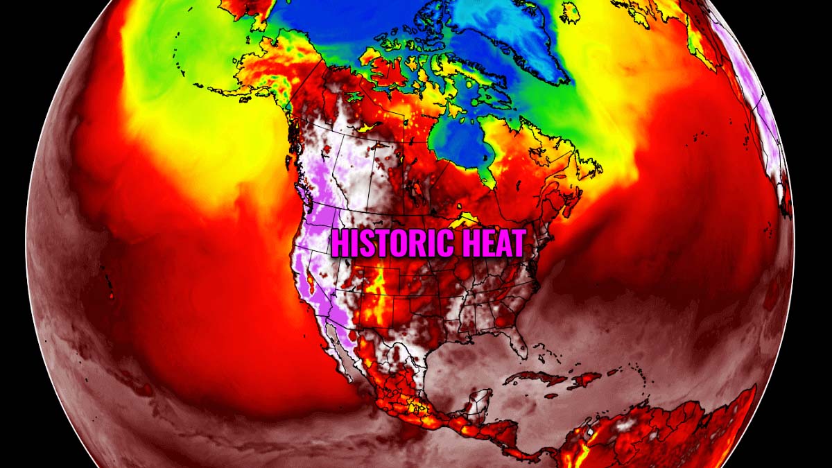
A historic triple-digits heatwave is literally baking millions of Americans and Canadians across the Pacific Northwest these days, thanks to the unpreceded heat dome trapping unusually hot air mass underneath. Extreme, record-breaking heat has already shattered numerous all-time high-temperature records over the weekend, with the worst of the heat coming up this Monday and Tuesday.
Summer months normally bring very hot or even extremely hot temperatures around the world. But when it so extreme as across the Pacific Northwest through this end of June, it is just too much. When one hears forecasters saying a prolonged, life-threatening, and historic event, it is time to be weather aware.
While the Atlantic tropical activity is usually in the focus as we enter the summer months, the heatwave is the next. Right now, the states of Oregon, Washington (US), and Canadian British Columbia are experiencing intense heat as never before. And the temperatures will get even higher over the next two days.
A life-threatening heat is expected to reach its peak through Monday and Tuesday, with many locations forecast to set their all-time historic temperature records.
Intense heat can be deadly. And statistically, it brings a high number of deaths around the world when so extreme temperatures occur. Especially if scorching heat develops over regions where heat is normally not as extreme.
The heat dome this week is beyond anything that has been observed across the Pacific Northwest before, hundred years old records are getting smashed. And it is not over yet, the worst arrives later today and tomorrow.
A blocking High, known as a dome of heat, has firmly established across the Pacific Northwest. The temperature animation below indicates the daily fluctuations in the heatwave across western North America, with extreme temperature anomalies to continue into the coming days. Interestingly, much cooler and refreshing weather than normal continues further south.
Numerous cities have opened cooling centers, where their residents can escape the heat in air-conditioned buildings. People are advised to avoid extended activity and periods of time outdoors, stay hydrated and help vulnerable family members and neighbors. Symptoms of heatstroke or heat exhaustion often include high body temperature, lack of sweat, fainting, unconsciousness, and confusion. Stay alert!
Many shops have sold out of portable air conditioners and fans. Although heatwave is nothing new for the Pacific Northwest, this region normally sees only mild weather and many people do not have air conditioning installed.
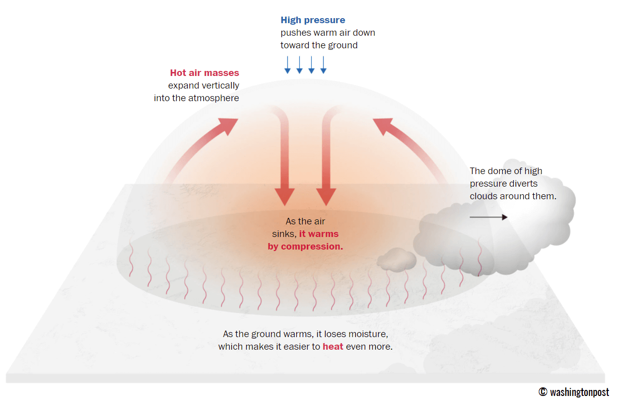
The use of the words ‘heat dome’ has become quite popular in recent days, thanks to something truly astonishing, weather-wise of course. This feature is often responsible for long-lasting and deadly heatwaves around the world.
WHAT IS A HEAT DOME?
A heat dome is an area of high pressure that parks over a large region like a lid on a pot, trapping heat underneath.
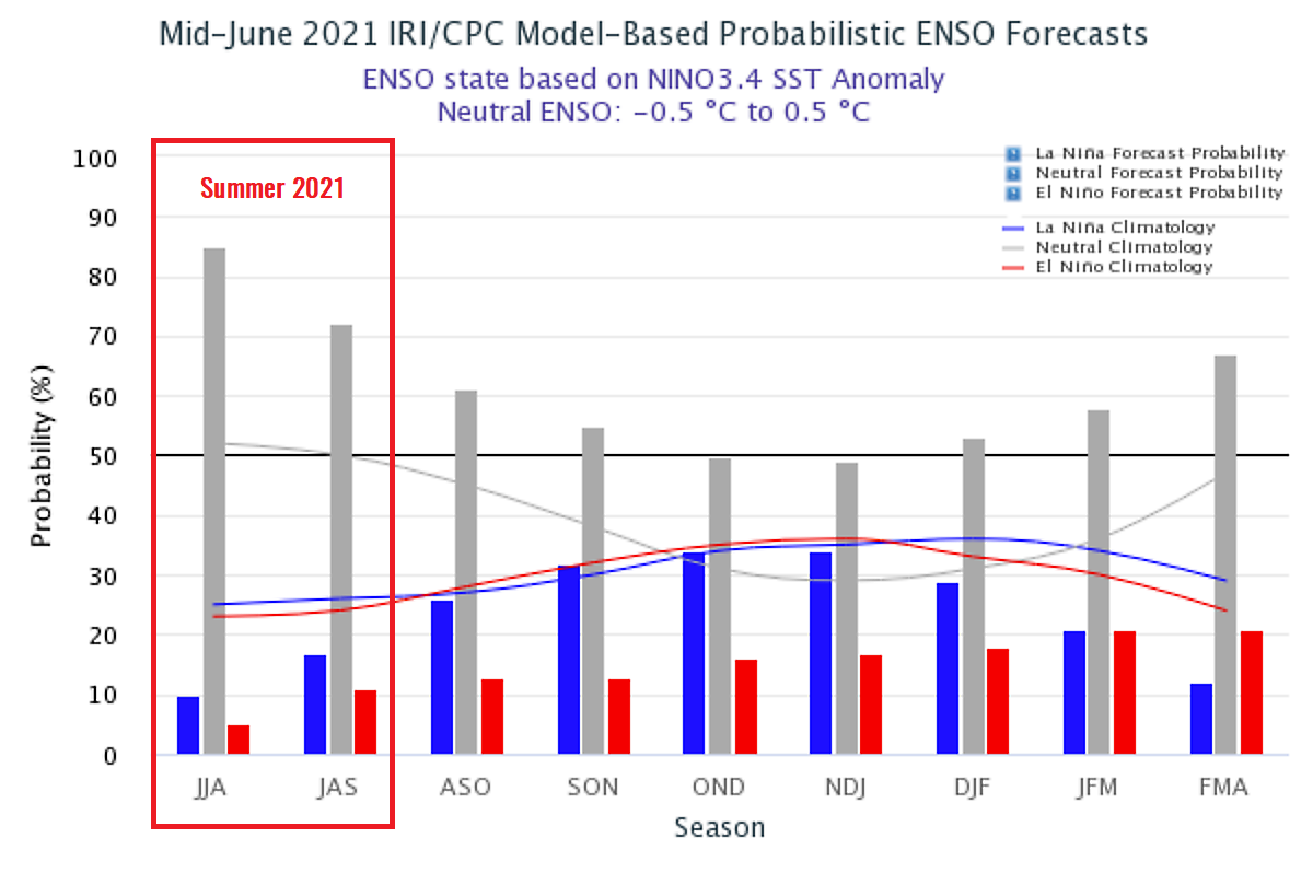
Actually, the early spring forecast by National Oceanic and Atmospheric Administration (NOAA) hinted at a high potential that a heat dome will develop this summer, thanks to the recently weakening La Nina global pattern going into the neutral phase. The Pacific Ocean waters are cooler in the eastern Basin during La Nina and warmer in the western Pacific Basin.
When this circulation happens, the temperature difference creates winds that blow the tropical air mass from west to east and the weather pattern gets this air trapped in the jet stream which ends up across the western portions of North America. This summer, neutral El Niño/La Niña Southern Oscillation (ENSO) is in effect.
So a heat dome is basically that trapping dome of heat beneath the extensive blocking High and surface high-pressure system. The persistent stable air mass begins to accumulate and develops the heatwave that normally lasts for several consecutive days and nights. Temperatures during a heatwave are typically well above normal.
If the heat dome is very strong – such as the Pacific Northwest of Canada and the United States is facing now – this large lid helps to sustain the heatwave at the surface. When a high-pressure system fully establishes, the subsiding air beneath it heats the lower atmosphere. The hot air masses also expand vertically into the higher atmosphere, creating a dome of high-pressure area, trapping everything below.
As we are seeing in these recent days, unpreceded record-breaking heat is resulting.
What is also pretty impressive is that the scorching heatwave event is actually happening so early in the summer. It typically develops through mid-summer across the Western United States and Canada.
For example, just last week, when a heat dome began its strengthening over the West Coast, early-season extreme heat hit California, Arizona, and Nevada. The city of Las Vegas shattered its record high temperature of 114 °F.
HEATWAVE SHATTERS HEAT RECORD AFTER RECORD, CANADA SETS NEW NATIONAL RECORD
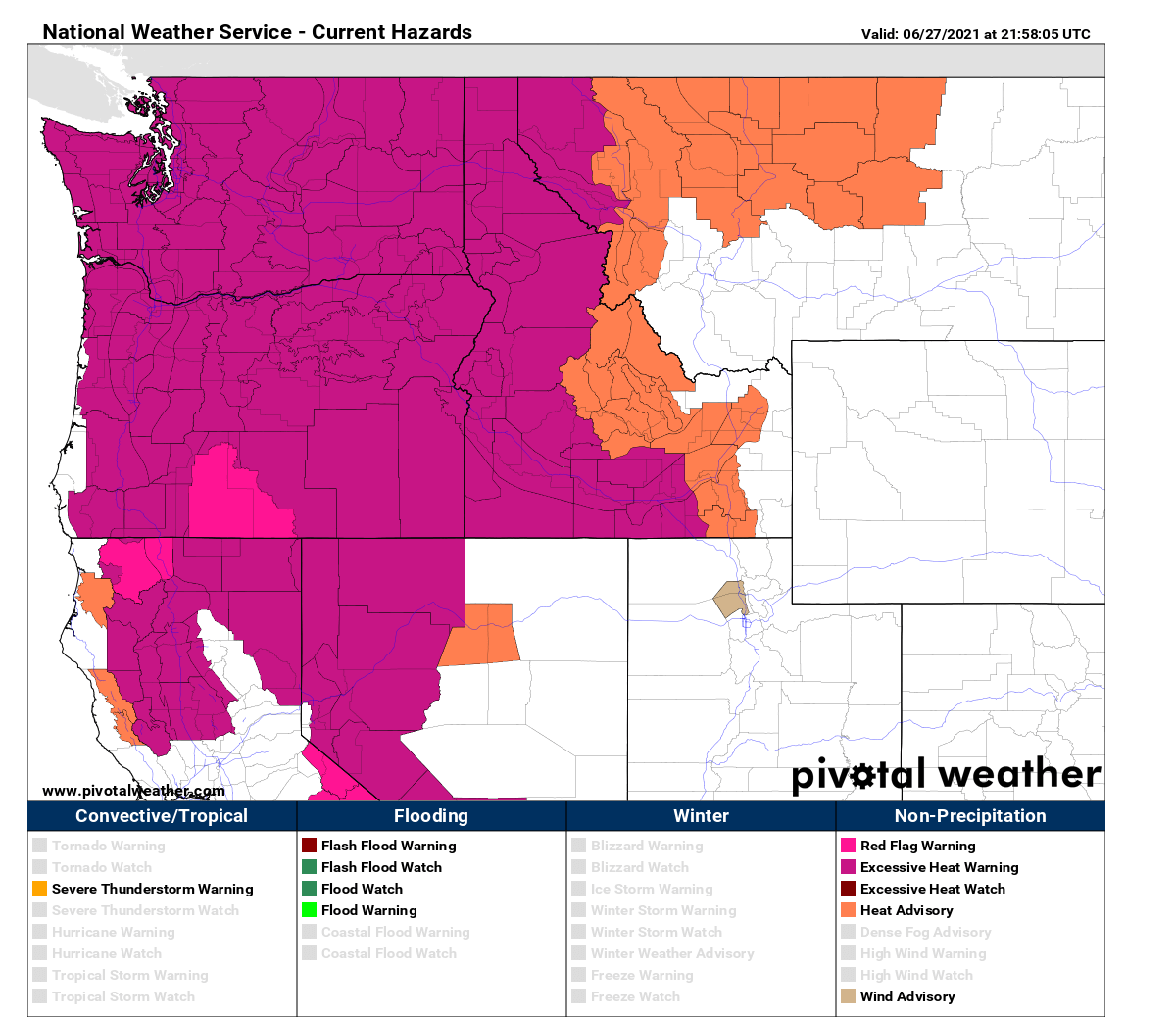
A sweltering heatwave has already hit large parts of the United States’ Pacific Northwest and Canada, shattering all-time records and puts millions under excessive heat warnings. The National Weather Service has issued those across nearly all of Washington and Oregon states, including parts of California, Idaho, Nevada, and even western Montana.
At 2 pm on Sunday, June 27th, the PDX airport (Portland, Oregon) set yet another heat record in line. The peak temperature was a remarkable 110 degrees Fahrenheit, the hottest temperature ever recorded since historical records began more than 80 years ago. The SEA-SeaTac airport (Seattle, Washington) recorded 103 °F at 2.30 pm and tied its all-time heat record since 1945.
Both Seattle and Portland cities are expected to break their current all-time high-temperature records very likely on Monday again, as the heatwave peaks. Oregon’s highest temperature ever recorded is 117 °F, set at the end of July 1939. While the highest ever temperature for the state of Washington is 118 °F.
Basically, the whole West Coast of the United States is baking in extremely hot temperatures, spread from California and Arizona in the south to Washington and Oregon to the north. While one would expect temperatures in triple-digits just in the desert Southwest, the US Northwest is no exception this time. Thanks to the historic heat dome aloft.

The attached chart above, provided by Mesonet is also pretty impressive for another reason. Take a look at the temperatures across the eastern two-thirds of the country. Those are actually *much* slower than the Pacific Northwest. A pretty remarkable chart to say at least. Just another sign of how extreme the heatwave there is.
Note that average high temperatures in June are into 70 to 80s across the Pacific Northwest, precisely across the interior of both Oregon and Washington, so these temperatures are 30-40 °F above normal. And are expected to continue over the next couple of days, being the highest with the worst heat this Monday and tomorrow.

Farther north in Canada, unprecedented heat has already shattered the national record. Something we do not read very often.
The town of Lytton, Canada has recorded an astonishing 115 °F (46.1 °C) which broke the existing Canadian record of 45.0 °C set in July 1937. Attached below is the temporal temperature at 2.30 pm in Lytton, British Columbia, already past the previous record. Image credits: The Weather Network.
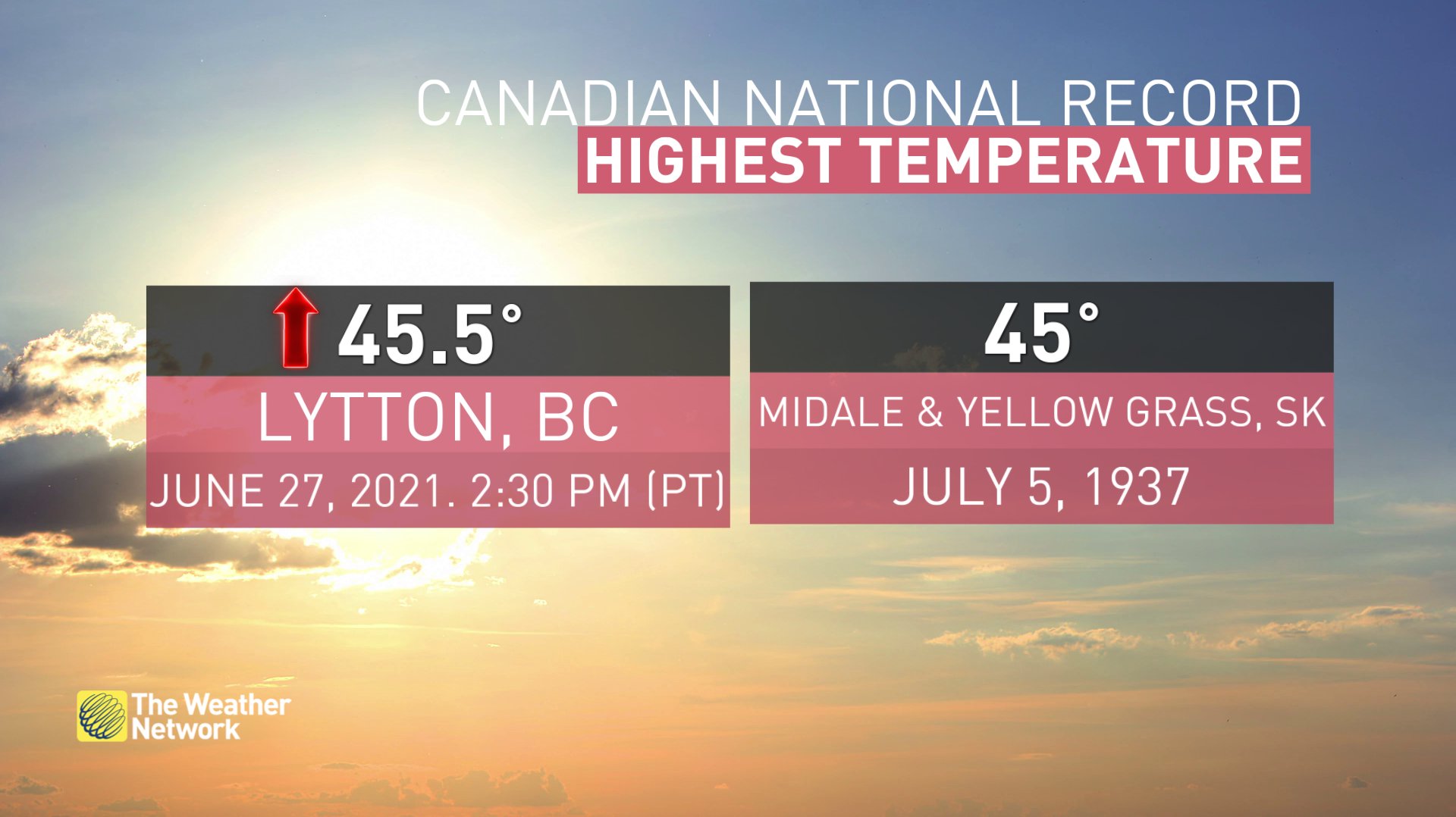
+46.1 °C recorded in Lytton, BC has also shattered the highest temperature ever recorded on Earth north of 50 °N latitude, the previous record was 44.4 °C back from July 1941.
Parts of British Columbia, Saskatchewan, Alberta, and the Northwest Territories are under a heat warning as well, extended until at least mid this week as more heat records are likely to be broken.

The all-time record high for British Columbia is 112 °F (44 °C) and with the forecast high reaching as high as 115 °F on Tuesday, this would break the existing all-time historic heat record for the state.
HEAT DOME SETS THE HEATWAVE PEAK ON MONDAY AND TUESDAY
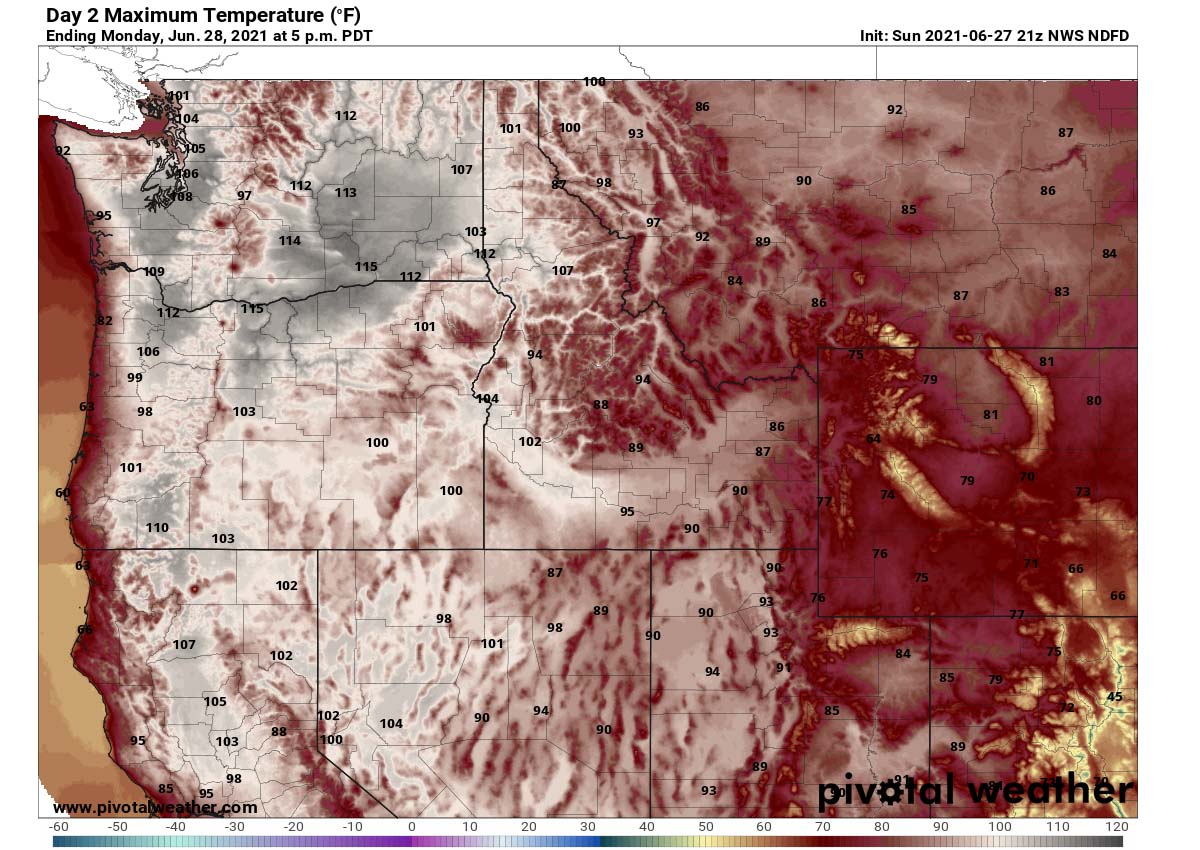
Now the worst of this heatwave is coming. This Monday, even higher temperatures are likely to be recorded across the Pacific Northwest, as the heat dome is near its peak strength, resulting in even hotter days underneath. Both Monday and Tuesday will be record-challenging days for Oregon, Washington, and British Columbia.
Monday will bring temperatures 110-116 °F across Washington, and parts of Oregon around 115 °F. Both states could possibly end up a tad higher in some localized valley where heat would be accumulated and boosted with some topography effect. Note that topography plays an important role when it comes to extreme heat, as downslope winds could help to push the temperatures even higher than forecast. Thanks to the effect known as adiabatic heating.
Parts of northwest Idaho, e.g. the city of Lewiston, could end up around 112 °F as well. Also in the triple-digits in the valleys of far northwestern Montana, into low 90s further east. Very hot temperatures will also continue further south across California and Nevada.
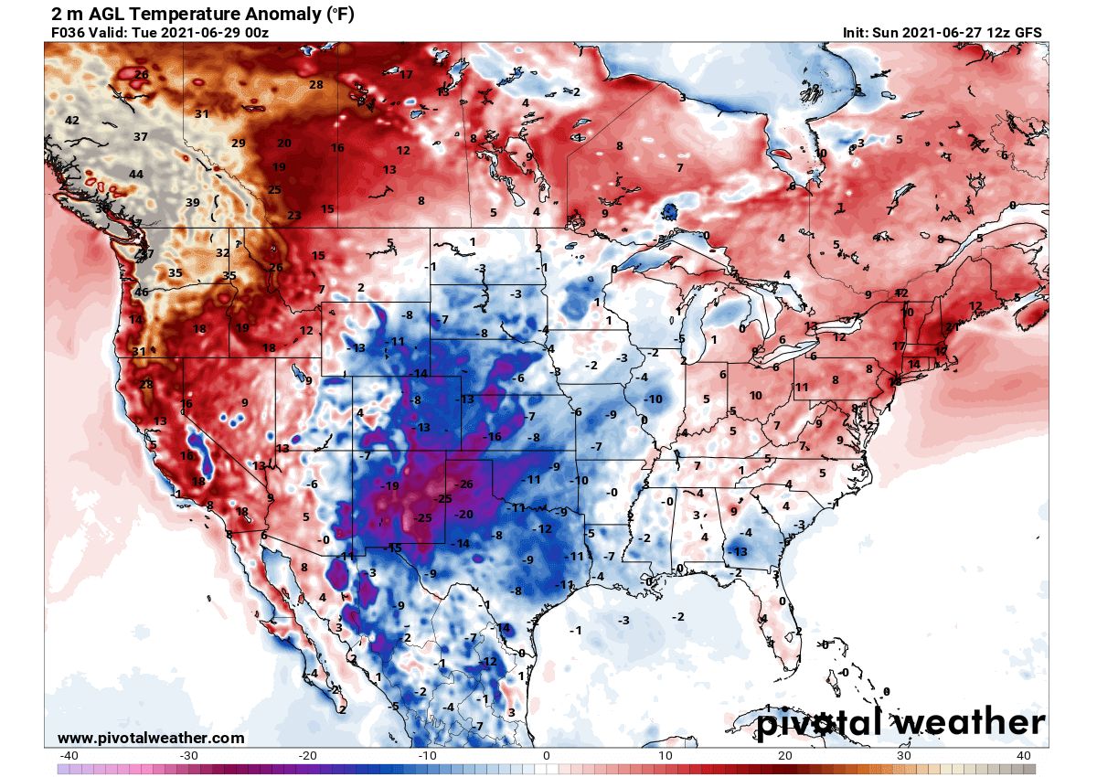
Attached below is the 2 m temperature anomaly across the United States and southern Canada on Monday, June 29th. Notice how remarkable the temperature difference is between the Pacific Northwest and the US Southwest. While 30 °F to more than 40 °F warmer than normal temperatures will be roasting British Columbia, Oregon, and Washington, parts of New Mexico (NM) will experience temperatures unusually cold for the end of June.
A large part of the NM state will see near or even more than 30 °F below normal temperatures, shattering daily low maximum temperatures. Creating a high temperatures contrast between the two regions, an exceptional 70-80 °F difference!
Towards Tuesday, the worst of the heatwave will move above British Columbia with temperatures nearly 50 °F higher than normal for the last days of June. But Washington state might have its final record-challenging day, again. The peak daytime temperatures are likely to rise above 115 °F in interior Washington, also extending into northern Oregon.
Similar to Monday’s highest temperatures, northeast Idaho could end up even higher and challenge its historic records again. It will become even hotter across Montana a well, temperatures are forecast to reach a few degrees Fahrenheit higher maximum on Tuesday.

An unpreceded heatwave is an event of such extent, that it will likely become one of the most intense and prolonged heatwaves in the recorded history of the Pacific Northwest. Sadly, besides the extreme heat, very dry air mass that is often accumulating under heat dome pattern brings nature increasingly vulnerable to wildfires as drought intensifies further.
Looking ahead, these extremely high and record-challenging temperatures could continue to the east of the Cascades and across western Canada also into the early days of July. So other areas further east could definitely see some record-breaking heat late this week as well.
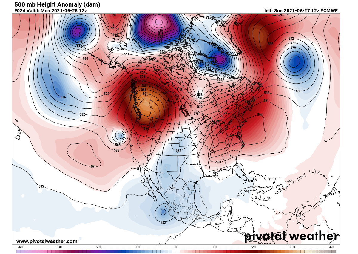
***The images used in this article were provided by Pivotal Weather, Tropical Tidbits, and NOAA.
SEE ALSO:
While the heatwave roast the Pacific Northwest, both the Eastern Pacific and tropical Atlantic are getting busy this week as well. Pacific has a hurricane Enrique active near the Mexico western coast while two tropical waves are moving towards the United States and the Caribbean region.
A large dust cloud is moving westward across the Atlantic Ocean, forecast to reach Caribbean and United States late this week.
A strong heatwave is also spread on the other side of the Atlantic, parts of Europe are having very hot days this week as well.