Is anyone counting these? There is just no limit in the North Pacific. Another explosive bombogenesis churned a spectacular extratropical storm south of Alaska, gradually moving towards the land. Violent winds and significant waves will blast into Southeast Alaska this weekend, the same areas that were severely hit twice this week. Further west, yet another intense storm is developing…
Previous discussion…
Seriously, you might be asking yourself now… wasn’t there a massive triple storm threat just two days ago? Yes. But last weekend also? Yes, indeed. Wait, but there was also a monster storm on New Year’s Eve… exactly. The North Pacific has been producing so many extratropical storms this winter, it’s hard to follow up with all of those. It reminds us of an incredibly active North Atlantic hurricane season last year that was generating storm after storm and become the most active season on record.
North Pacific just took a higher gear this winter season. This is the effect of the existing La Nina pattern, which is resulting in much above-average cyclone activity over the North Pacific. Most of the storms are gaining strength very fast and move towards the Aleutian Islands, Alaska mainland, or the Pacific Northwest of the United States and Canada.
This new storm arrives just a few days after a large North Pacific storm hit. That storm had three cores and two of those hit Southeast Alaska with violent, locally hurricane-force winds. And it did the classic, developed into yet another deep extratropical low and underwent an explosive intensification over the last 36 hours. It has peaked at 961 mbar this Friday and is now moving towards Alaska, expected to bring violent winds late this Saturday into Sunday.
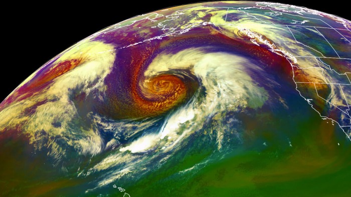
The extratropical storm appears quite remarkable on satellite scans this Friday, with a textbook core surrounded by a massive dry conveyor belt wrapping it around. Attached below is the geocolor satellite scan of the storm in the early Friday morning. A textbook cyclonic structure with an impressive sting jet wind maximum visible. The storm has become pretty large, dominating the North Pacific with a well-defined frontal boundary extending southwest towards the north of Hawaii.
The system is near its peak today and although it is not intensifying much more, it remains very large and supporting violent winds. These winds are generating major waves, moving east-northeast to the south and southeast of the storm’s center. Gradually moving towards Southeast Alaska over the next 36 hours, so this weekend.
Here is a quite spectacular satellite animation of the explosive development of this storm, as seen by the Water Vapor and Airmass satellite scans through all layers. The storm really took off explosively on Thursday when a pronounced dry intrusion pushed into the core and its central pressure has deepened significantly since then.
The system’s violent, hurricane-force winds have generated major waves that are gradually being pushed towards Southeast Alaska and the Pacific Northwest. The impact will be the most robust this weekend when the low comes closer to the land, then sharply turning north-northwest along the Southeast Alaska coast. Its deep core and very tight pressure gradient will develop another dangerous wind event for the region. And indeed bring more rain and snow into the mountains.
Let us see the details regarding the potential impacts to Southeast Alaska and the Pacific Northwest this weekend.
SPECTACULAR SATELLITE PRESENTATION
The rapid/explosive intensification of this new storm has resulted in a very impressive satellite presentation of the whole system. The cyclone has deepened from around 995 mbar on early Thursday morning local Pacific time to almost 950 mbar by Friday morning, so again around 45 mbar pressure drop in about 24-30 hours. During the system’s most explosive strengthening, its pressure fall was around 12-15 mbar per 6 hours period, this has happened on late Thursday. The intensification rate was then lower since last night, but the storm continued deepening.
A closer look into the storm through the visible satellite channel indicates the textbook dry intrusion, followed by an Arctic air mass advection behind it, spreading towards the eastern part of this extratropical storm. The structure is almost symmetrical in the center, with an impressive tightening pressure in the center, with nicely visible cyclonic cloud patterns. This is a great presentation of the dry conveyor belt wrapping into the eastern core, with a textbook appearance of the occluding low and dry intrusion visible. Winds have become violent with near 200 km/h gusts.
There is also an obvious violent wind maximum – a so-called sting jet. A sting jet phenomenon is a narrow zone of strong winds, originating from within the mid-tropospheric cloud head of explosive cyclogenesis. Winds are enhanced further as the jet descends, drying out and evaporating a clear path through the precipitation. The evaporative cooling leads to the air within the jet becoming much denser, causing the acceleration of the downward flow towards the tip of the cloud head when it wraps around the cyclone center.
The above is another satellite view, provided by CIRA/RAMMB NOAA. It shows an exceptional view of the storm’s core with hints of mesovortices embedded within a large circulation of the storm. Notice a wide dry conveyor belt wrapping into the core! That’s pretty spectacular!
EXPLOSIVE STRENGTHENING, AGAIN
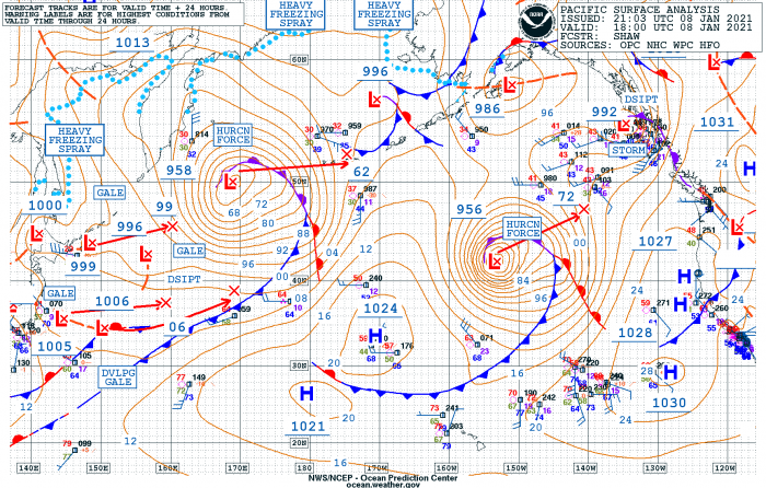
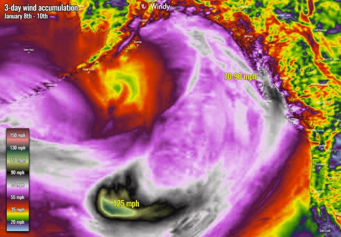
The central pressure of the extratropical storm has deepened to 956 mbar by Friday morning local time (18 UTC) while the whole system continued northeast across the North Pacific, heading for the Gulf of Alaska. Winds have increased significantly and have reached violent hurricane-force speeds. And its peak intensity is occurring just now, so the storm’s strength has brought it into a very intense system. Peak gusts are likely near 125 mph (200 km/h).
Below are the estimated surface analysis data for the mean sea-level pressure by the NOAA Ocean Prediction Center (OPC), begining with the storm’s birth od Wednesday until today:
- 956 mbar at 18 UTC, Jan 8th
- 964 mbar at 12 UTC, Jan 8th
- 961 mbar at 06 UTC, Jan 8th
- 977 mbar at 00 UTC, Jan 8th
- 988 mbar at 18 UTC, Jan 7th
- 992 mbar at 12 UTC, Jan 7th
- 993 mbar at 06 UTC, Jan 7th
- 995 mbar at 00 UTC, Jan 7th
The central pressure in this extratropical storm has had an impressive 32 mbar pressure fall in the last 24-hour period between Thursday 18 UTC and Friday 18 UTC timeframes. There was also a very explosive strengthening between 00 and 12 UTC yesterday, with a remarkable 27 mbar pressure drop in a 12-hour period only. You should be aware that the threshold for the bombogenesis is 24 mbar per 24 hours, so this was double the official threshold!
The bombogenesis process occurs when a midlatitude cyclone very rapidly intensifies, dropping at least 24 millibars over 24 hours. This can happen when a cold air mass collides with a warm air mass, such as air over warm ocean waters. The formation of this rapidly strengthening weather system is a process called bombogenesis, which creates what is known as a bomb cyclone.
STORM PEAKS TONIGHT, NEW STORM OVER ALEUTIANS
The system now continues moving towards the northeast, actually, it is dominating the whole North Pacific Ocean and will move into the Gulf of Alaska this weekend. Looking over the pressure forecast across the North Pacific tonight, we can see the low will maintain very low central pressure, likely staying below 960 mbar until Saturday morning. Notice also there is another deep low traveling east along with the Aleutian Islands. This is another extratropical storm and is progressing eastward faster, so it will catch up with the eastern low this weekend.
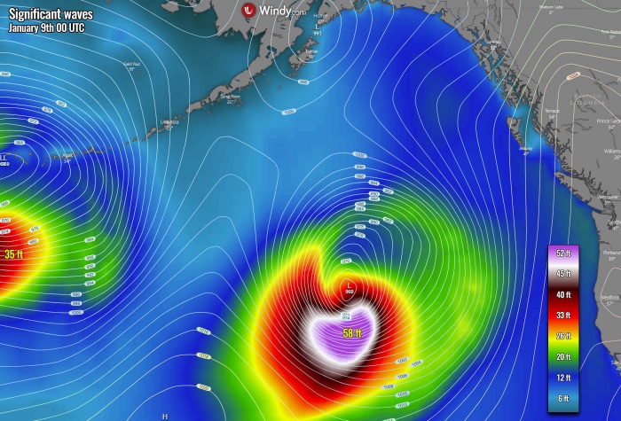
As we discussed earlier, the very rapid to explosive strengthening of the featured storm is producing violent, hurricane-force winds that a result of a textbook development of a sting jet wind maximum. The peak wind gusts are reaching around 200 km/h this Friday and generating very significant waves. As some weather model guidance hints, those are likely above 55 feet (16+ meters) up to nearly 59 feet (18 meters). Fortunately, this wind maximum and the waves are far from the coast, otherwise, they’d be destructive.
STORM NEARS SOUTHEAST ALASKA ON SATURDAY
While the featured storm (eastern) matures through Friday night, it will be moving towards Southeast Alaska on Saturday. Its central pressure will be gradually rising, but the pressure gradient will be strengthening on its front edge. Notice the isobars (lines with the same pressure) are very close together, this means winds will increase. Just in time when the storm moves along the land while turning north-northwest into the Saturday night. The Aleutian low will grow even bigger, moving closer to the featured low.
One of the concerns is surely also significant wave height, remaining above 35-45 feet with the eastern storm while gradually spreading towards the Pacific Northwest coast of Canada and the United States, as well as into Southeast Alaska. We can see that despite the rising central pressure of the storm, its size and intensity on Friday is so big, that the swell and major waves survive much longer. Those could be even more than 35 feet when reaching the coastal areas.
STORMS COLLIDE OVER THE GULF OF ALASKA ON SUNDAY
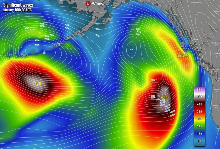
Going into Sunday, the steering flow will be turning the eastern extratropical storm northwest and push it even closer to the new storm moving across the Aleutian Islands. Both storms will actually collide into one large storm, dominating the weather across the Gulf of Alaska and Alaska itself. The central pressure will deepen further once they collide and will likely bottom out around 960 mbar. The final storm will reach its peak then, gradually losing its strength through late Sunday into the night. But will remain very large.
Widespread winds around this new merged low will maintain major waves, affecting both Southeast Alaska and the Pacific Northwest coast. While the waves will be around 25 feet on Sunday morning, they will be bigger later when the main core of the significant wave heights progress further east. The highest waves will be above 40 feet in the core, located to the south of the storm’s center. We can see the waves are spread across a quite wide channel, extending for several hundred miles across.
Here is an overview of the peak wind gusts throughout this weekend, ending on Monday morning (3-day period). The sting jet wind maximum is perfectly visible, gradually vanishing the most intense winds further east from the current position. However, the wind swath of severe winds is pretty wide and the model has this broad channel well-defined, curving northeast with the movement of the low. When the storm moves along Southeast Alaska on late Saturday, tightening of the pressure gradient should intensify the winds, with gusts potentially near 70-90 mph on the most exposed places.
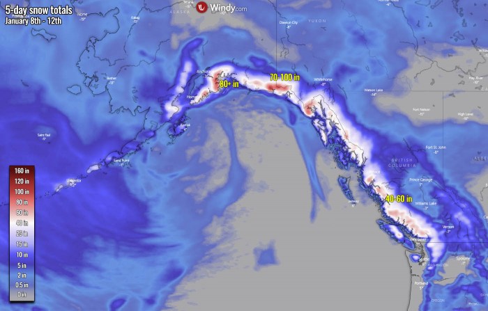
As it is typical with these storms, more snow will develop across the Northern Rockies and across the south and Southeast Alaska. Models are in good agreement that locally extreme amounts of snow are likely over the next 5 days. From 40-60 inches (100-150 cm) across Southeast Alaska and western portions of British Columbia mountain range to the impressive 70-100 inches (150-250 cm) of snow across the mountains of southern Alaska. There, persistent moisture inflow leading to intense orographic snowfall will occur.
***The images used in this article were provided by Windy, Wxcharts and NOAA.
See also:
