2021 started with two consecutive winter storms across the eastern and part of the southern United States, now a new winter storm is scheduled to hit the deep South this weekend. A frontal system emerges over the southern Rockies, moving to Texas and then turning towards the Southeast US. Quite some snow with worsening driving conditions will develop from Texas through Louisiana and Mississippi until Monday.
Just a few days after two winter storm events hit the eastern and southern United States, there is now another one developing this weekend. A quite significant winter storm will travel from New Mexico east across Texas into Lower Mississippi Valley, bringing a lot of snow in parts of Texas. Winter weather with slippery and icy conditions will develop, with dangerous driving conditions expected.
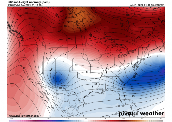
A frontal system with a cold front is moving across the West Coast and will develop a new surface low-pressure system over New Mexico and the southern Rockies. It will drop down to the Rio Grande into the western Gulf of Mexico, beneath the amplifying upper-level trough diving southward through the Central and Southern Rockies into Sunday. Snow will spread across New Mexico and Texas from late Saturday through Sunday, some of which could be heavy at times.
A WINTER STORM WATCH has been issued for portions of western, central and eastern Texas. Rain will switch over to snow by Sunday morning. The higher elevations could see higher snow totals of 6 to 8 inches. A WINTER WEATHER ADVISORY has been issued for the Panhandles and eastern New Mexico, as well as a WINTER STORM WARNING in parts of New Mexico. Travel could be very difficult as roads become slick and snow-packed.
Snow will fall over all of the areas beginning late Saturday through Sunday. This new system could produce 6-8 inches (15-20 cm) of snowfall over parts of the Southern Plains on Sunday. Locally close to 10 inches (25 cm) of fresh snow could accumulate. Heavy rains are possible late on Sunday along portions of the Texas coast as the low moves into the westernmost Gulf of Mexico. With some storms, including possibly becoming severe along the northwest Gulf Coast.
According to the National Weather Service (NWS), a storm system should move into North and Central Texas Saturday night and exit the region Sunday night. Most of the area is expected to receive snowfall. The heaviest snow should remain to the south and west of Dallas-Fort Worth with widespread 1-3 inches of snow accumulation possible. Where heavy snow will develop, localized higher amounts are likely. Here is what we know about this new winter storm evolution so far:
UPPER WAVE DEEPENS OVER THE ROCKIES
A strong winter storm will track across Texas late Saturday and into Sunday. Widespread precipitation will form within this storm system, transitioning from rain to snow across much of the region on Sunday. While there remains some uncertainty on the exact snowfall amounts that can be expected, and where the heaviest snow amounts will occur, accumulating snowfall appears likely for portions of North and Central Texas beginning late Saturday night and continuing through the day Sunday.
The overall weather pattern across North America reveals an upper-level high across Canada and the northern United States, with a long-wave ejecting off the Mid Atlantic to the Atlantic. Further west, another upper wave is moving across the southern Rockies, amplifying while drifting southeast this Saturday. It will travel across New Mexico, emerging into Texas on Sunday into Sunday night. The general flow over the continent is supporting northerly air mass advection, therefore resulting in a lot of freezing fog across the United States.
We take a look at the 925 mbar temperature here, which is often best to represent the size and the intensity of the pools for cold or warm air masses. 925 mbar geopotential heights are roughly near 750 meters (or 2500 feet) above sea level, so it helps us to avoid the effect of potential complex topography beneath. The temperature chart this Saturday indicates that there is a broad area of below-freezing temperatures at this level, including deep south of the United States, from eastern Texas across the Lower Mississippi Valley into Southeast US.
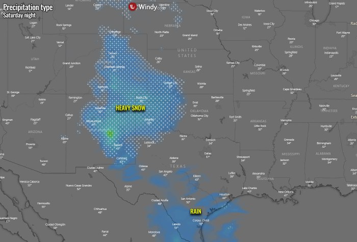
As the surface pressure also begins falling over western Texas, it helps the warm air mass and moisture advection further north. Together with the new wave emerging over the southern Rocky mountains tonight, snowfall will gradually increase from eastern Colorado into New Mexico and the Panhandles. Heavy snow will develop with time, and a winter storm is forecast to gradually continue towards the southeast. So the snow is first to increase across eastern New Mexico, then also into Oklahoma and Texas Panhandle.
A potent winter storm system will bring significant snowfall to the northern mountains late today, spreading over eastern New Mexico tonight through Sunday morning. Travel impacts are likely across most of eastern New Mexico. Some uncertainty remains regarding locally higher snow totals of 1 to 4 inches (3-10 cm) over parts of the middle Rio Grande Valley tonight into early Sunday morning. It is indeed strongly depending on the frontal system’s trajectory where and how intense the snowfall will occur.
Significant snowfall accumulations of 6 to 12 inches (15-30 cm) are possible over the Sangre de Cristo Mountains with 3 to 6 (7-15 cm) inches and locally as high as 6 to 9 inches (15-25 cm) over portions of the eastern plains. Snowfall will first begin to reach the northern mountains Saturday afternoon and will then expand over the eastern plains Saturday night into Sunday morning. The system finally exits into Texas by midday Sunday. Travel impacts from snow-packed roads and lowered visibility are likely through mountain passes and the interstate and highway corridors east of the central mountain chain to the Texas border.
WINTER STORM DEVELOPS EAST ACROSS TEXAS ON SUNDAY
As the wave moves into the southern Plains and Texas through Sunday morning, the temperatures also become lower over the region. Those will be favorably low to support snowfall with the increased precipitation. The main large cold pool will remain further east and northeast, across the north and the central United States. Near-surface temperatures over Texas are low on Saturday, as freezing fog has been reported. So although snow might be more wet than dry, it will be accumulating on the ground quite easily. Especially when intensity increases.
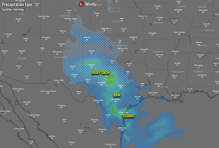
By Sunday morning, the wave progress will already bring an increase in precipitation into the west and central Texas. Heavy rain will develop across the deep South, but heavy snow and a rather significant winter storm further north. The heaviest snowfall will develop across western Texas and the southern Texas Panhandle in the morning hours, gradually spreading east during the late morning into afternoon hours. Where exactly the boundary with mixed precipitation (snow and rain) will be placed is hard to tell, but some good estimates can be judged from the chart below.
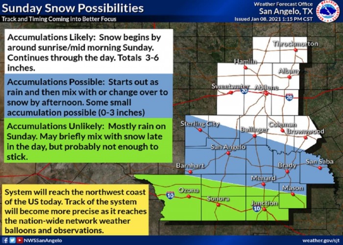
According to the National Weather Service in San Angelo, Texas, snowfall begins around sunrise on Sunday morning, continues east through the days. The highest accumulation, locally 3-6 inches (7-15 cm), are likely along the Interstate I-20 with less chances for any significant snow accumulations further south around San Angelo and west/east of it. Indeed mainly rain to heavy rain further south towards Sonora and Junction along the Interstate I-10.
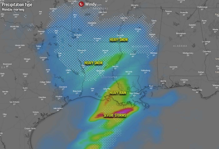
Through the Sunday evening and night hours, precipitation continues to increase as the upper wave is deepening while traveling eastward across Texas. While snow to heavy across will spread into central Texas, a mixture of both rain and snow are likely further east. At least at the beginning of the precipitation until temperatures become lower. Snowfall will be losing its intensity further west as less moisture will be present. Very heavy rain will develop across southern Texas and along the Gulf Coast, with chances for severe storms along with the coastal areas.
According to the National Weather Service in Dallas-Fort Worth, Texas, the front edge of the winter storm will reach this part of Texas by late Sunday morning, increasing precipitation with time through the afternoon into evening hours. There is potentially up to around an inch of snow across northern Texas, and up to 3-4 inches (7-10 cm) further south of Interstate I-20. The highest amounts of snow seem likely to the south and west of the Dallas-Fort Worth metroplex. Bands of heavy snow will be likely with this event, so some areas could see some reasonable amount of snow as well.
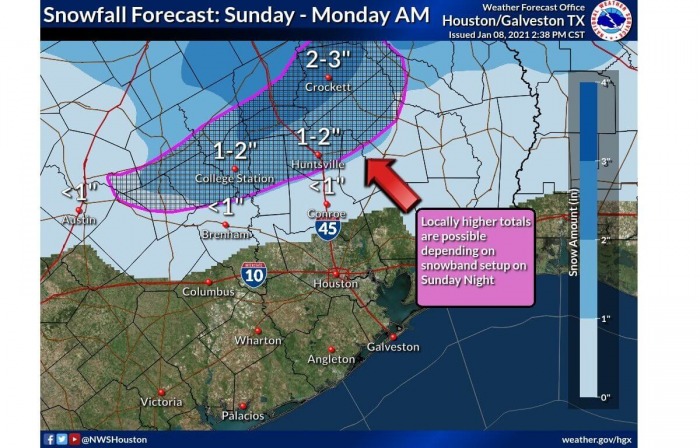
According to the National Weather Service in Houston, Texas, the winter storm will develop measurable snow down south as to just north of the Houston area, roughly north of the line between Austin-Brenham-Conroe and further east. Although the amounts of fresh snow will not be significant at any level, the total snow accumulations of 1 to 4 inches (3-10 cm) are possible with isolated higher amounts further north towards Crockett.
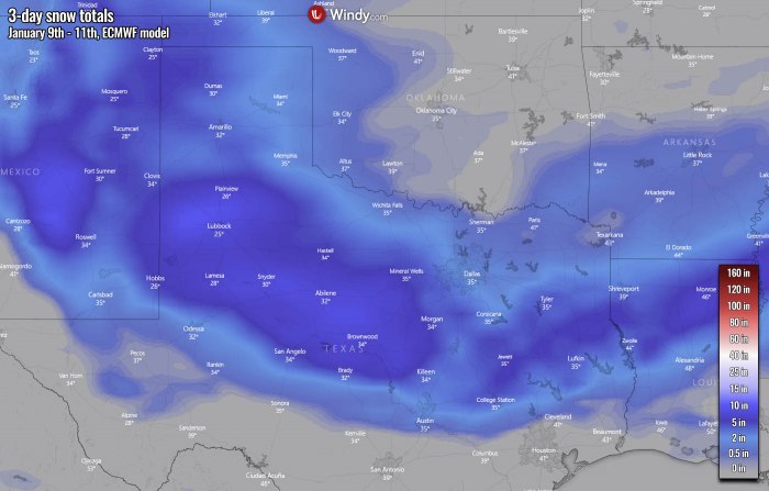
Here is now a general map of the total snowfall accumulation expected by the ECMWF weather model with this winter storm event. The highest amounts are expected across western and central Texas, locally 6-8 inches (15-20 cm) of snow will be possible. The other two areas will a reasonable amount of snow are over New Mexico and also across the Lower Mississippi Valley. These areas could see around 4-6 inches (10-15 cm) of snow, potentially some more, depending on where exactly the frontal system travels.
As the intensity and the amount of snow accumulation strongly depends on the position of the surface fronts and the wave trajectory, differences in the weather model predictions exist. The ECMWF model might be near the probable reality, we must not ignore the local, high-resolution models, e.g. NAM model. The latter hints even more than 12 inches (25+ cm) locally. Especially across central Texas while the ECMWF model predicts the highest amounts of snow further west.
We can see that most of the southern Plains will see at least some snow, obviously the highest amounts along with the core of the eastward-moving winter storm, from eastern New Mexico into western and central Texas, as well as further east into eastern Texas and northern Louisiana. Keep in mind the high-resolution model NAM could be a bit too optimistic, but chances are surely there and should not be ignored.
STORM MOVES ACROSS MISSISSIPPI VALLEY ON MONDAY
The upper wave with the frontal system will continue east on Monday, bringing the winter storm across the Lower Mississippi Valley from the early morning hours onwards. Actually, this upper wave will be the only disturbance across the United States Lower-48 this coming week, as the rest of the country will be under above normal geopotential heights and surface pressure. The wave will, however, be gradually weakening and losing its strength while drifting east.
The eastward-moving upper wave will also result in lowering the temperatures in its wave, so colder air mass spreads across the freshly accumulated snow over Texas on Monday. The coldest temperatures remain further north across the central Mississippi Valley and the Midwest. Freezing temperatures could push into Deep South as well. We can also see that as the surface low advances east along the central Gulf Coast, the warm advection ahead of it brings warmer temperatures into portions of the Southeast United States.
One of the results of the warm advection from the Gulf of Mexico will surely be heavy rain with storms, possibly even severe storms, along the central Gulf Coast. Locally flooding could occur as well. Further north, a winter storm will continue east across northern Louisiana, southern Arkansas into north-central Mississippi through Monday morning. Heavy snow will spread across northern and possibly also Louisiana, depending on where the frontal boundary will travel.
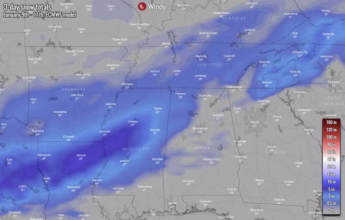
Although the snow amounts might not be particularly extreme, snowfall this far south is rare enough that just a few inches of snow could cause significant travel problems. The highest amounts are likely across north-central Louisiana and west-central Mississippi, as the attached ECMWF model guidance suggests. 4-6 inches (10-15 cm) of snow can accumulate along this swath, with 1-3 inches (3-8 cm) of snow to the north and south. Up to central Arkansas and further east across Tennessee.
***The images used in this article were provided by Windy, PivotalWeather and NOAA.
See also:

