An extraordinary display of tropical power is unfolding off Mexico’s Pacific coast, where Hurricane Polo explosively intensified into a monster Category 5 storm with sustained winds of 180 mph (155 kt = 285 km/h) and a minimum central pressure plummeting to 892 mbar. Polo is driven by record-warm ocean temperatures fueled by the ongoing super El Niño and underwent one of the most violent rapid intensification cycles on record.
Hurricane Polo strengthened from a tropical storm to a high-end Category 5 system in under 24 hours.
The primary engine behind this rapid intensification is an exceptionally favorable thermodynamic environment off southwestern Mexico, with sea surface temperatures hovering near 31-32 °C and extremely low vertical wind shear. This is an ideal scenario for extreme tropical system intensification.
Hurricane Hunter reconnaissance missions confirmed that Polo reached an incredible central pressure of 892 hPa, making it the second-most intense Pacific hurricane in recorded history, only falling just behind Hurricane Patricia (2015). Polo has reached Category 5 status three times, making it the first Pacific hurricane on record to do so. Yet it is intensifying further Friday night after completing an eyewall replacement cycle early Friday.
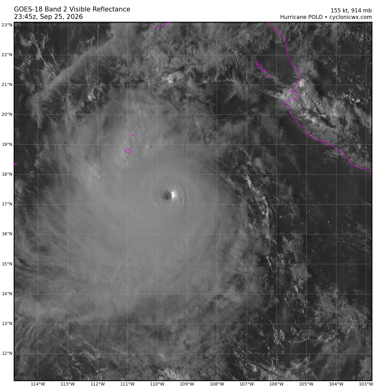
While the latest forecast model guidance indicates that Polo’s core will remain slightly offshore rather than making a direct, destructive landfall, the storm’s massive circulation is already battering coastal regions from Guerrero to Colima and Jalisco. Severe rainbands are delivering 150 to 200 mm of torrential rainfall across steep mountain chains, triggering life-threatening flash floods, catastrophic mudslides, and dangerous coastal storm surges along the Mexican shoreline.
Satellite observations and hurricane-tracking models below show Polo’s exact offshore trajectory, illustrating the evolution of its tight eyewall and the immense tropical moisture plume spreading toward northwestern Mexico over the coming days.
The key message – current weather advisory:
Storm classification: Category 5 hurricane
Maximum sustained winds: 155 knots / 180 mph / 285 km/h
Peak wind gusts: 180 knots / 210 mph / 330 km/h
Central pressure: 907 mbar
Primary threat: Baja California Peninsula on Monday
Winds: 200-250 km/h gusts
Rainfall: 10–15 inches expected near the core path
Hurricane Polo’s buzzsaw rotation underwent a classic eyewall replacement cycle Thursday night, emerging larger, more structured, and even more dangerous, with a much wider destructive wind field. And it is strengthening again.
Major tropical activity is also over the Eastern and central Pacific, with another Category 4 hurricane, Odalys, and Hurricane Nolo to the south of Hawaii.
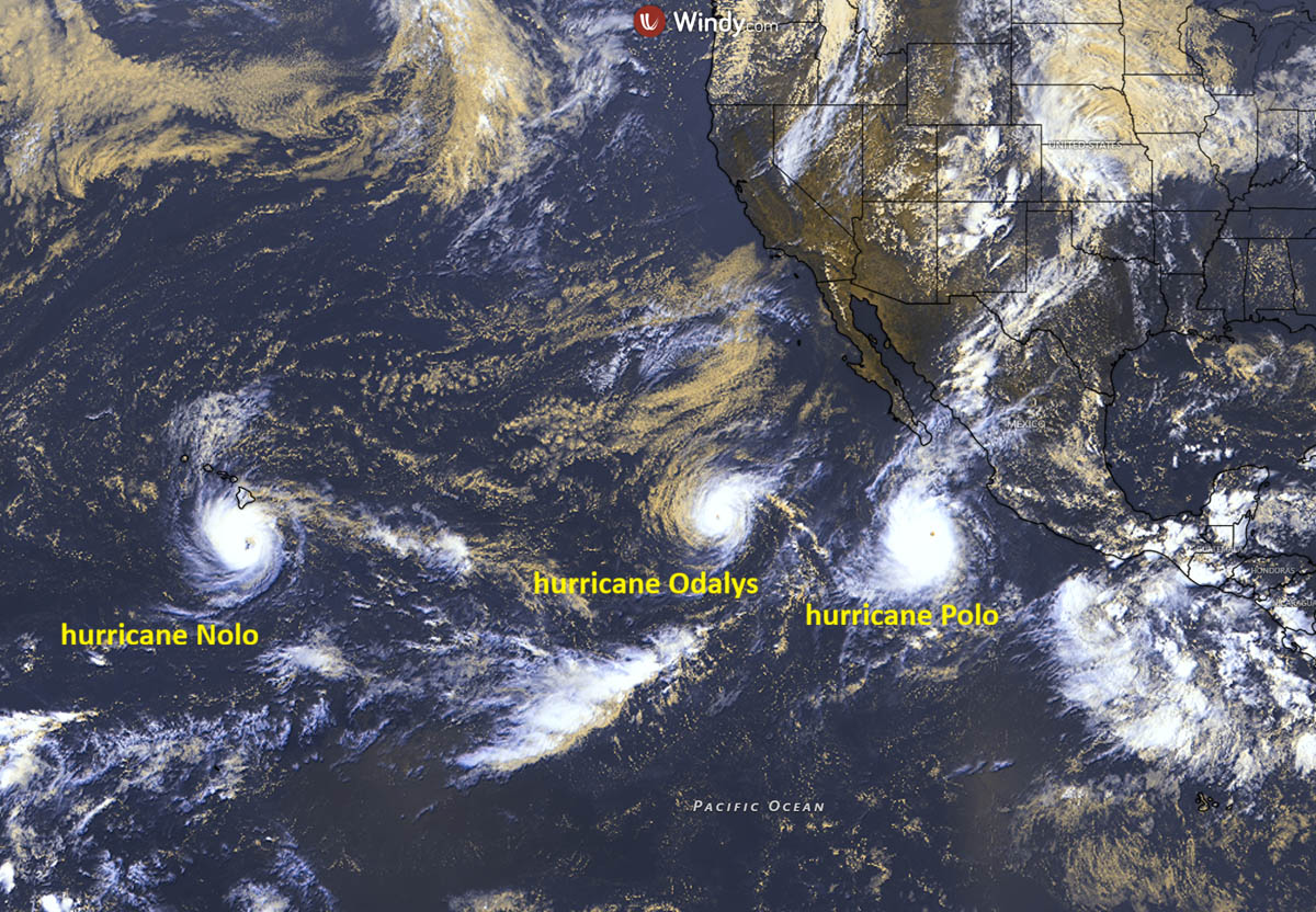
Let’s look at the region’s current conditions, the forecast tracks, and the storms’ impact.
Record-high seawater temperatures across the Eastern Pacific due to historic El Niño
Sea temperatures across the eastern tropical Pacific remain extremely high and record-breaking this month, ranging from 28 to 32 °C. These high water temperatures lead to higher dew points and elevated near-surface energy, so convective storms ingest this volatile air mass and support explosive thunderstorm activity.
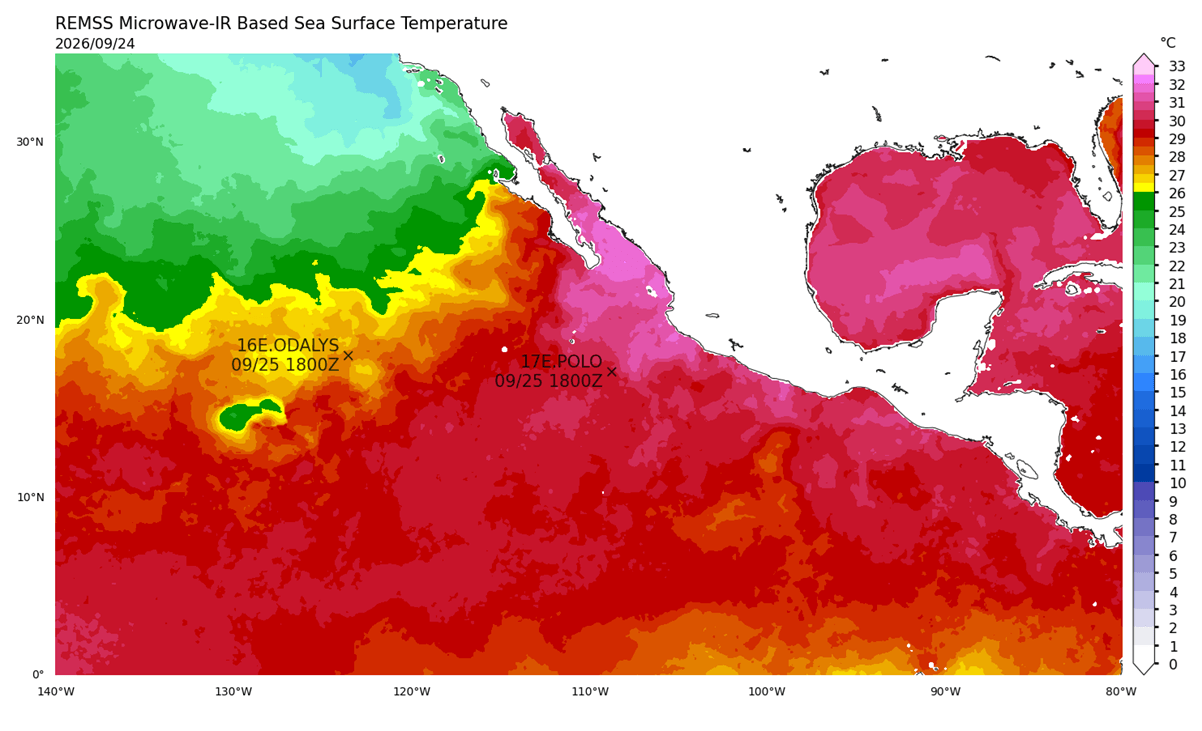
These sea surface temperatures are about 4-6 °C above average for the end of September in the region. This is followed by the record-breaking El Niño, which is still strengthening, with astonishing temperature anomalies observed across the central and eastern Pacific Ocean.
The warmest sea temperatures are along the Baja California Peninsula, where Hurricane Polo’s path is forecast to make landfall. Temperatures exceed the long-term average by 5-6 °C.
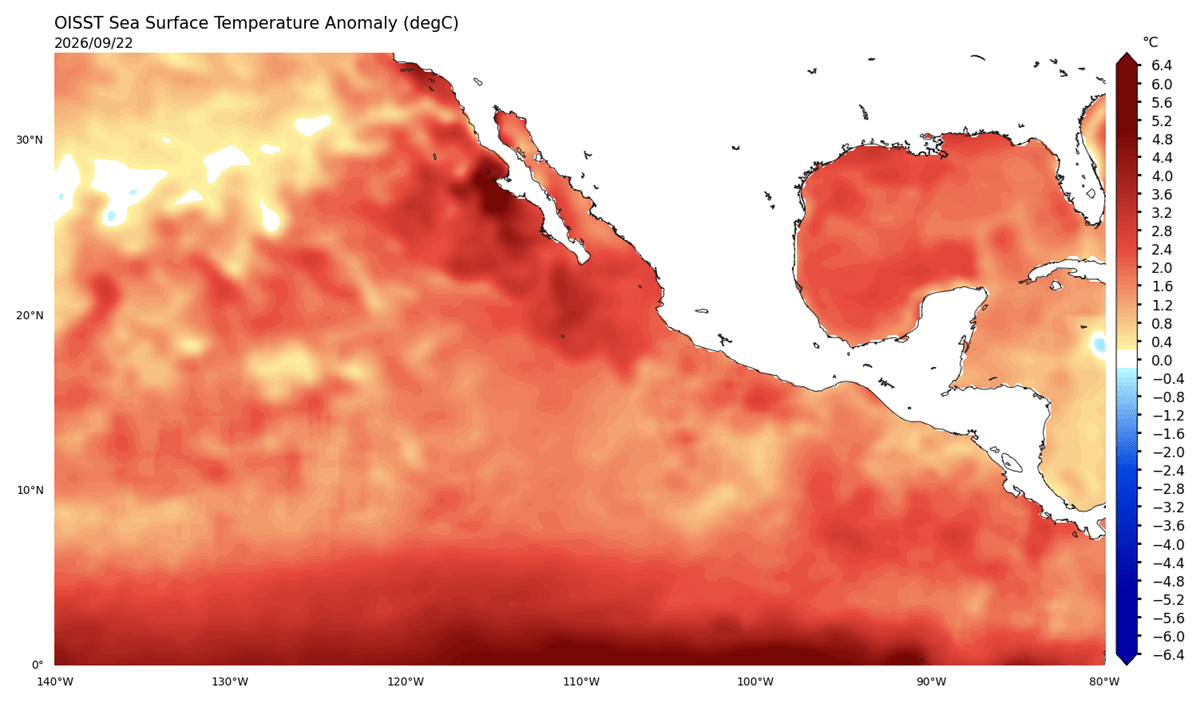
Any tropical system that enters such warm waters gains strength. This is why the east-central Pacific currently has 3 intense hurricanes: Category 5 hurricane Polo, Category 4 hurricane Odalys, and Category 2 hurricane Nolo.
Extremely hot, record-breaking sea waters are the main reason why Hurricane Polo underwent so explosive intensification earlier this week. Extremely high water temperatures led to its rapid intensification into a Category 5 monster storm in less than 24 hours.
So far, the Eastern Pacific hurricane season has churned 19 tropical systems, including 9 hurricanes and 6 major hurricanes (Category 3 or greater).
Hurricane Polo is the world’s fifth Category 5 storm, on its way to the Baja California Peninsula on Monday
Hurricane Polo has reached Category 5 strength three times over the last 5 days; the other 4 storms of such intensity were Tropical Cyclone Horacio in the South Indian Ocean on February 23rd, followed by the Super Typhoon Sinlaku
in the Western Pacific on April 12th, 2026, Super Typhoon Bavi in the Western Pacific on July 5th, 2026, and Hurricane Genevieve in the Eastern Pacific on July 27th, 2026.
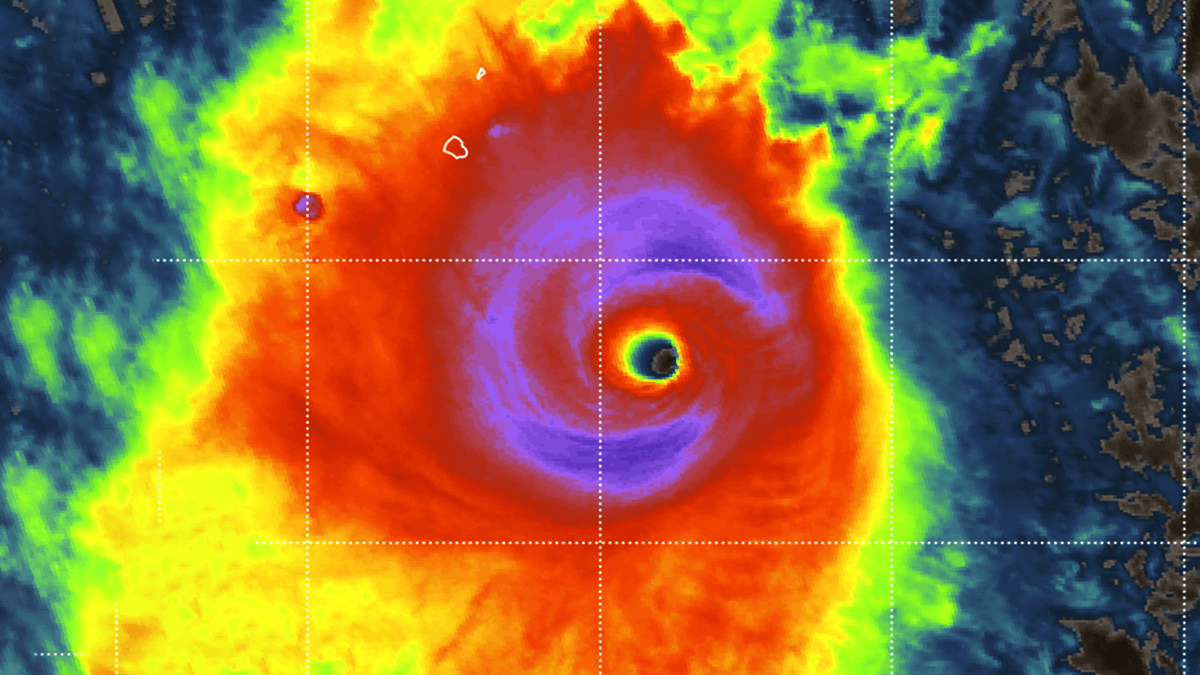
Automatic satellite analysis of Major Hurricane Polo indicates estimated peak winds near 160 knots, consistent with a Dvorak intensity of 7.7. The central pressure is estimated to be around 902 mbar.
The most intense winds extend 50-60 miles from the core in all quadrants, indicating a symmetrical buzzsaw shape with an expanding wind field. Tropical-storm-force winds extend up to 165 miles from the large eye.
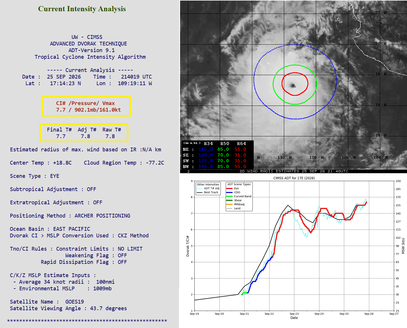
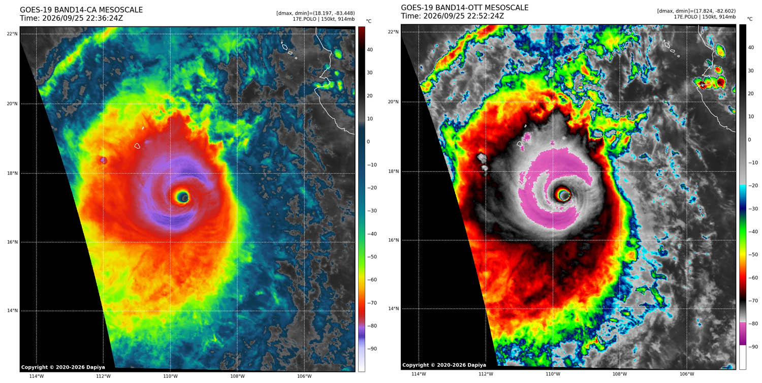
The infrared satellite shows how impressively large Hurricane Polo is. The astonishing buzzsaw-shaped COD surrounds the violent eyewall. The following infrared scans are a near-perfect picture of the monster Category 5 storm.
Through Friday, Polo has re-strengthened again into a powerful Category 5 storm, sustaining 180 mph winds. This is followed by the eyewall replacement cycle from Thursday night, when the inner eyewall collapsed and was replaced by a larger outer secondary eyewall, and re-intensification began on Friday.
Over the weekend, Polo will continue tracking west-northwest and is likely to continue strengthening and maintaining its Category 5 strength, thanks to extremely hot 31-32 °C sea waters underneath and no shear in the region.
The most likely scenario involves Hurricane Polo moving towards Baja California from Sunday night into Monday, impacting the south-central parts of the peninsula. The extremely intense wind field associated with Polo will bring impacts of at least high-end Category 3 or even Category 4 strength.
Violent, destructive winds, catastrophic storm surges, high waves, and torrential flooding rain will batter the peninsula’s western coasts. The damage will be extreme.
According to weather models, the worst winds will likely weaken before Hurricane Polo reaches the Baja California Peninsula, but because the wind field is so large, the impact will still be destructive. Combined with heavy rainfall.
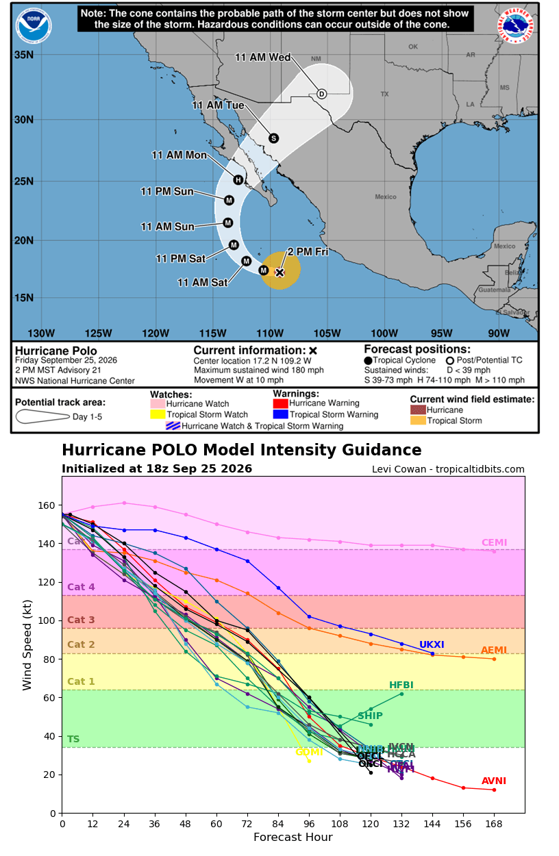
Hurricane Polo will then continue northeast while weakening before making another landfall in northwestern Mexico Monday night into Tuesday.
The swath of violent winds will be large as Polo continues west-northwest over the next two days. While it may reach even stronger winds and sub-900 mbar central pressure again before Sunday, it will then begin a gradual weakening phase as it curves toward the Baja California Peninsula. Winds will be violent across a broad area around the center.
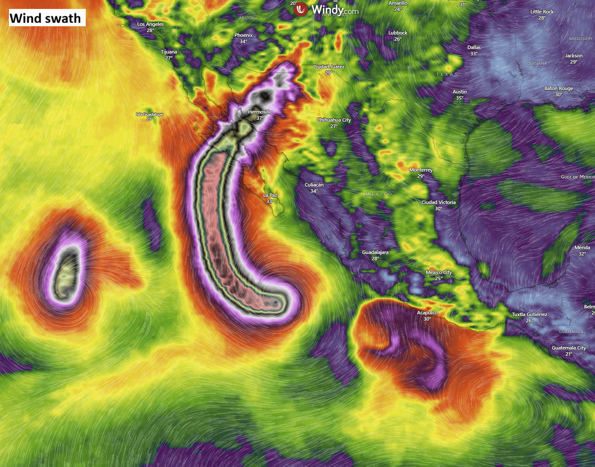
The central pressure should remain between 900 and 910 mbar for another 24 hours; it could drop even further if intensity changes significantly, e.g., the inner core tightens again, and Polo establishes a pinhole eye. Normally, eyewall replacement cycles (ERCs) occur in tropical cyclones of these sizes and intensities. When they occur, intensity fluctuates, so future intensity depends heavily on them.
The hurricane’s core is also where the heaviest rainfall is expected. Most weather models predict that 150-300 mm of rain will likely fall along its path when Polo reaches the south-central Baja Peninsula on Monday, possibly even higher amounts if the storm remains stronger than currently anticipated.
Extreme rainfall will fall over Baja California’s mountainous terrain, potentially reaching up to 300-400 mm (12-15 inches) within two days. Destructive flash floods could occur. The most likely scenario indicated a potentially significant flooding impact across Guerrero, Michoacán, Colima, and Jalisco, river flooding, port closures (Acapulco, Zihuatanejo, Manzanillo), and emergency shelter deployments.
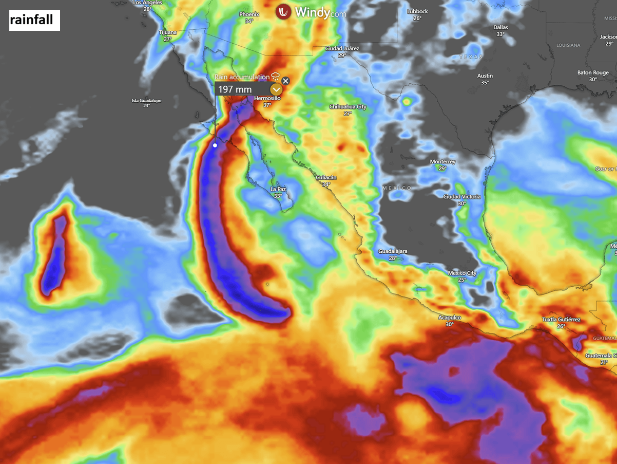
After Monday’s impact, Polo will weaken rapidly as it tracks toward northwestern Mexico for its secondary landfall, but it will remain a powerful storm with severe winds, more flooding, and storm surge expected.
Windy, CyclonicWX, and Tropical Tidbits provided images used in this article.
See also:
Super El Niño Builds a Strong Hurricane Shield for the United States, Lasting Into October