The Summer season of 2022 will be under the continued influence of the La Nina, as the jet stream pattern over North America and the Pacific Ocean shows. The Summer forecast from major weather models captures this jet stream pattern, revealing a very hot and dry summer developing for parts of the United States and Europe.
When trying to understand any weather season and the long-range forecasts, we must realize that there are many global drivers that can shape it. Global weather is a very complex system, with many large-scale and small-scale factors.
Seasonal forecasting focuses on large-scale pressure systems and the jet stream positioning with the weather pattern. Over the Northern Hemisphere, this upcoming Summer season will be under the influence of a now well-known Ocean anomaly.
OCEAN INFLUENCE ON SEASONAL WEATHER
A major driver of the cold season was the ENSO. That is short for “El Niño Southern Oscillation”. It is a region of the tropical Pacific ocean, changing between warm and cold phases in the equatorial ocean. Typically there is a phase change in around 1-3 years.
Below we have an image that shows all the ENSO regions in the equatorial Pacific. The main regions are 3 and 4 and cover a large part of the tropical Pacific. The main analysis and forecasts are focused on the nix of both regions, marked as Nino 3.4.

ENSO has a major influence on the tropical rainfall patterns (storms) and the complex exchange between the ocean and the atmosphere. Large-scale pressure changes are observed in the tropics as ENSO phases arise and reach their peak.
The image below from NOAA Climate shows the typical circulation during a negative ENSO ocean event. Air is descending in the eastern Pacific, creating stable and dry weather conditions. In contrast, air rises in the western Pacific, causing clouds and a lot of rainfall in the western Pacific.

Through this process, ENSO has a major impact on the tropical convection patterns and consequently on the ocean-atmosphere system.
A specific ENSO phase (warm/cold) usually develops around late summer and early autumn and can last until next summer, or even up to two years in some cases.
The cold ENSO phase is called La Nina and the warm phase is called El Nino. Besides the temperatures, one of the main differences between the phases is also in the pressure state.
Below we have the latest global ocean anomalies, revealing the cold region in the tropical Pacific. That is the currently active La Nina phase.

Focusing on the ENSO 3.4 region, you can see in the image below how the ocean temperatures dropped in Fall 2020 which was the start of the first La Nina. It has dissipated by last Summer, with a new cold phase starting last Fall.

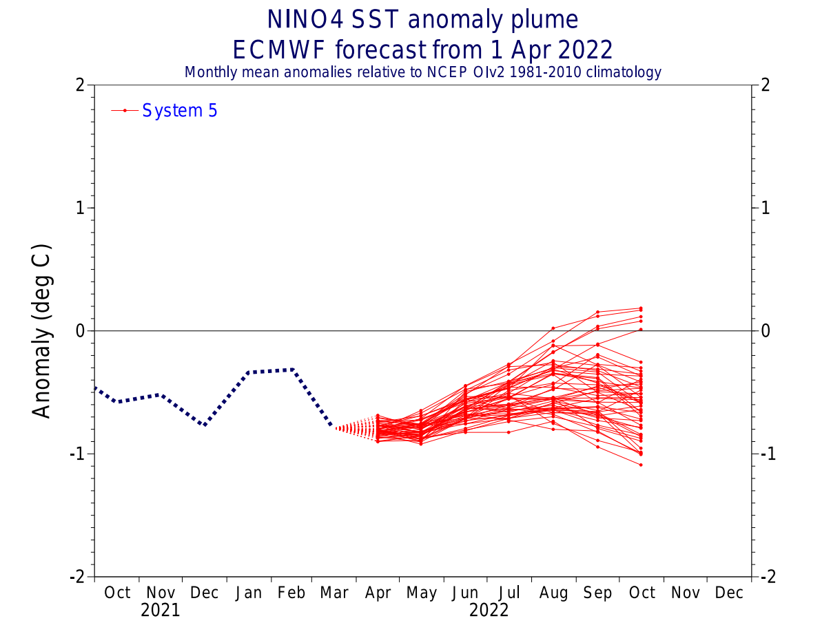
Below we have the latest ocean temperature anomaly forecast for the Summer season from multiple global long-range models. It shows the presence of the cold ENSO phase across the equatorial Pacific Ocean. But the main cold anomalies are focused on the central tropical Pacific.
The ECMWF ensemble forecast for the central Nino 4 region shows the sustained negative anomalies over the summer and even into fall. This is a big change from the earlier forecasts in the past few months.
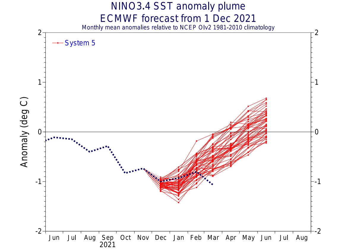
Below we have the ECMWF ensemble forecast from December. It was forecasting a quit breakdown of the La Nina and a transition towards the neutral-warm phase during the summer. But changes in the tropical pressure patterns have now prolonged the cold phase at least into early summer.
For a better idea of the ENSO development, we produced a video that shows the emergence of the La Nina last Fall.
The video below shows the cold ocean anomalies starting to emerge in late Summer last year. Notice the “waveforms” across the region, as the surface waters are being pushed west by the trade winds.
Knowing now what is behind the global weather patterns on a larger scale, we can now look at what its influence is on weather and the jet stream.
WEATHER AND THE JET STREAM
Typically, the first influence of these ocean anomalies can be seen in the jet stream. The jet stream is a large and powerful stream of air (wind) at around 8-11km (5-7mi) altitude.
It flows in a west-to-east manner around the entire Northern Hemisphere. It affects the pressure systems, and their strength, thus shaping our weather on the surface.
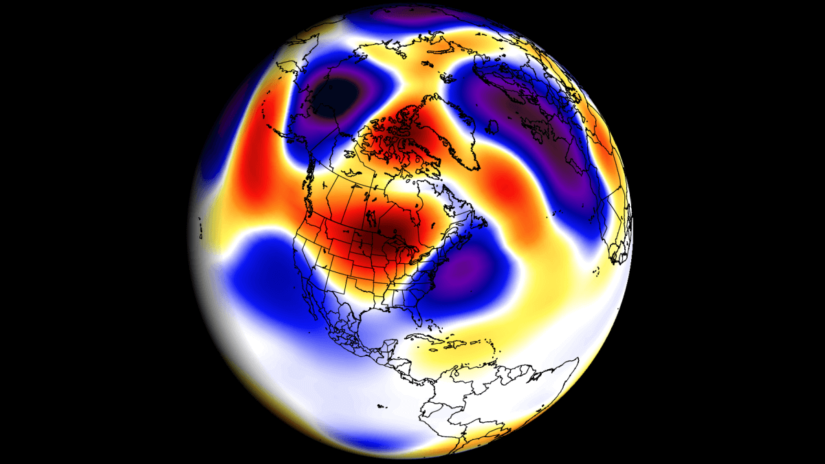
Below is an example of the winter jet stream at the 300mb level (9km/5.6mi altitude). In this example, the jet stream is quite deformed down over the central United States, which brings colder air down from the north.

Over northwestern Europe, it moves upwards into the polar circle. Such a pattern brings colder weather to the eastern United States and stormy weather to Iceland and the British Isles.
In the image below we have the correlation between cold ENSO and the summer jet stream. We can see a stronger jet stream over the northwestern United States, and a weaker subtropical jet stream over the southern United States in a La Nina Summer.
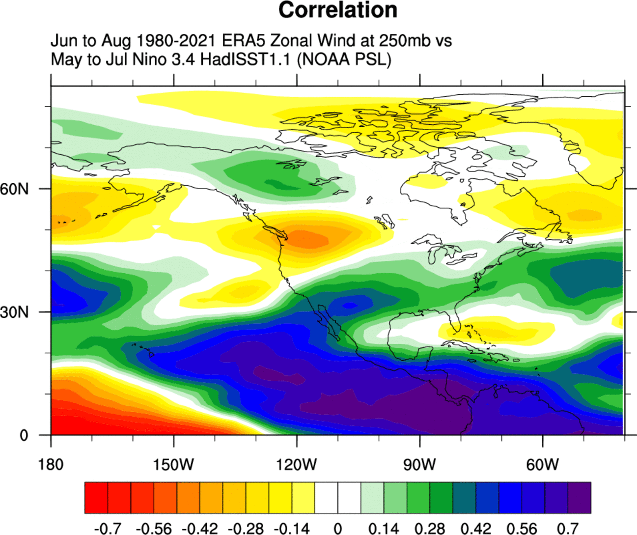
Historically, the most typical winter effect of a cold ENSO phase is a blocking high-pressure system in the North Pacific.
We can see below, that the North Pacific high-pressure tendency in a La Nina also exists during Summer. The high-pressure pattern extends from the North Pacific into the west/central United States.

But we can see an even stronger signal for a high-pressure system over the northeastern United States, centering to the east into the North Atlantic.
We are focusing on the Pacific/North American region in this case, because the warm season La Nina influence is most profound here. Unlike in the cold season, there is much less (or none) of a direct weather pattern effect on the European sector.
Below we have the Summer temperature and precipitation anomalies for the United States in Summers following a Spring La Nina.
We can see warmer than normal temperatures over much of the western half of the country. Of note is a colder than the normal signal for the southeastern United States.

Precipitation-wise, we have a drier signal for a La Nina Summer over much of the north, central and western United States. More precipitation is hinted over the Ohio Valley and the northeastern United States, and also in the southeast.
ECMWF SUMMER SEASON FORECAST
Knowing now what to expect from the La Nina in Summer, we will take a look at the latest (early) long-range forecast trends.
We typically use the ECMWF first, as is often referred to as the most reliable model in the long-range category. In reality, a lot can change with the individual year/season. But generally, the ECMWF model is at the top as far as “reliability” goes.
But no long-range/seasonal forecasting system can be called “reliable“. We are only looking at trends and how the weather patterns are evolving on a large scale and over longer time periods.
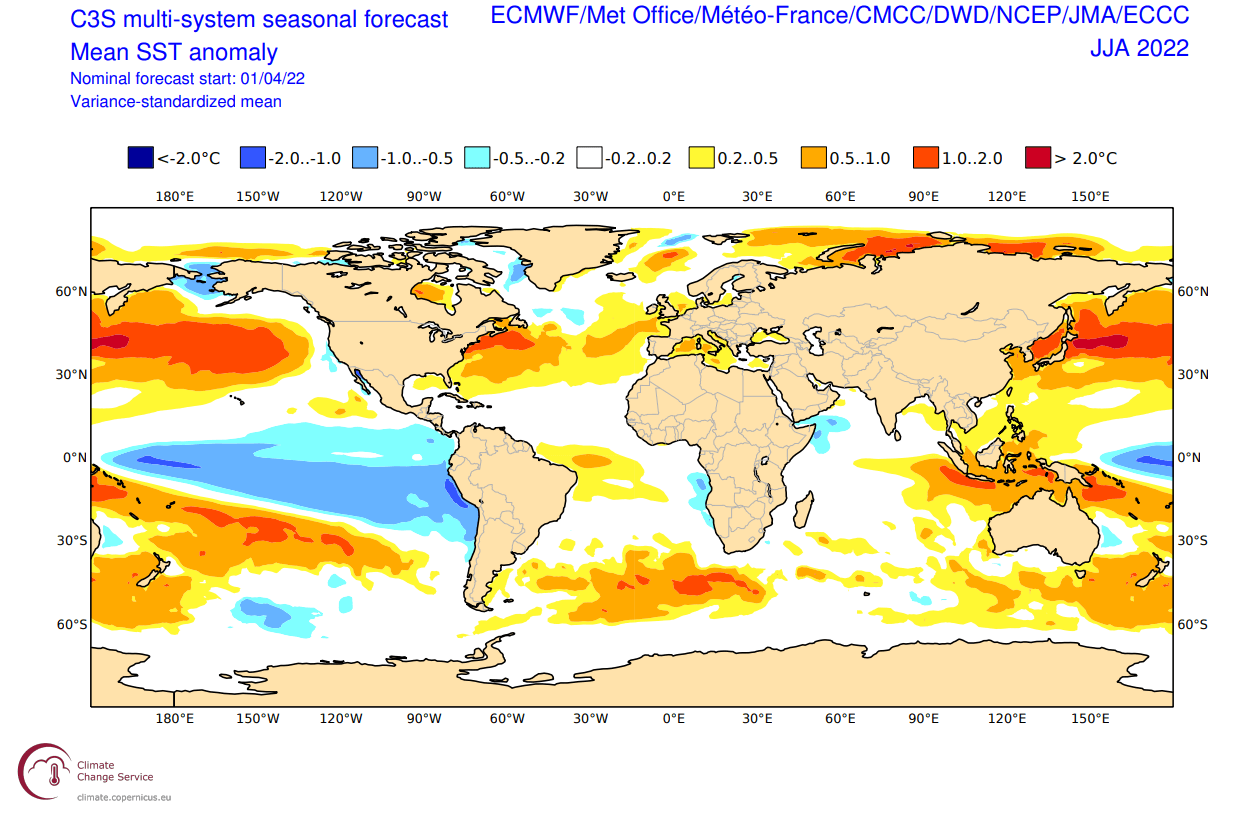
The forecast period we will be focusing on in all models is June-July-August (JJA 2022). This period covers the meteorological summer and is the peak of the warm season.
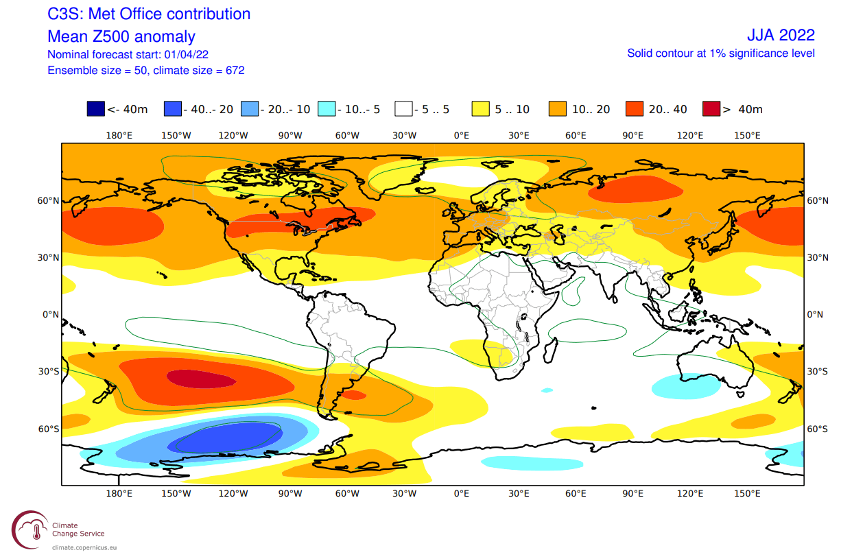
In the pressure pattern forecast from ECMWF below, we can see a La Nina high-pressure system remaining in the North Pacific. It extends over the western/northern United States.
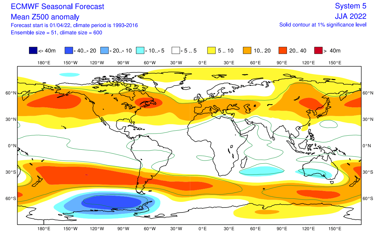
A stronger high-pressure area is found over the northeastern United States as we have seen in the La Nina signal graphic earlier above. This will have a regional effect on the weather development in the eastern United States and eastern Canada.
Another high-pressure system is over western Europe, with a low-pressure area contrasting over northern Europe.
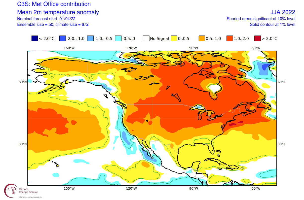
The global temperature distribution follows this pattern. Over North America, we see warm pooling over the central and northern United States. That is the warmer airmass under the high-pressure anomaly. Warm anomalies also extend over much of southern and eastern Canada.
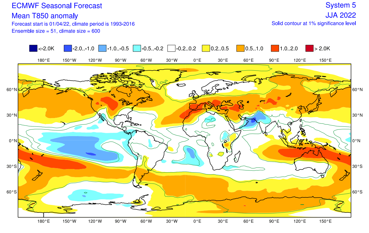
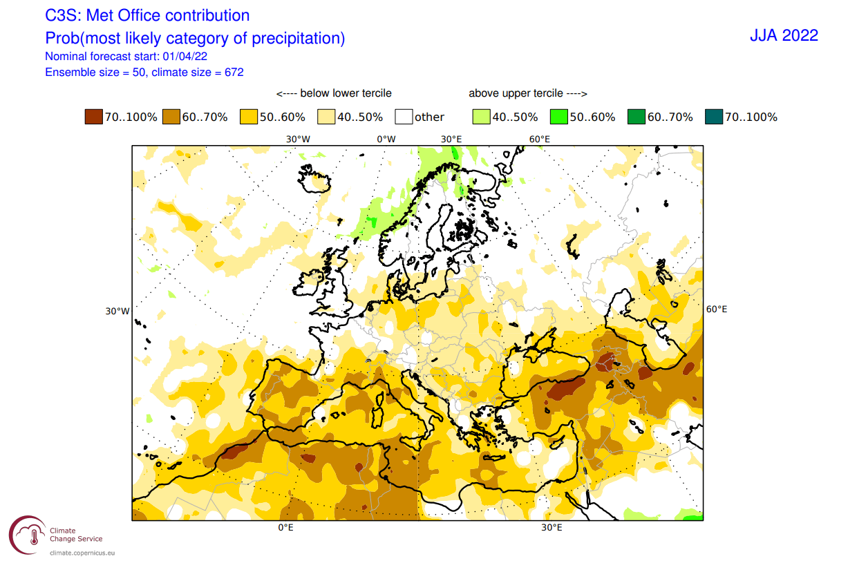
Europe features mostly warmer than normal conditions over the entire south-central half. Northern Europe however is seen neutral, under a likely cooler low-pressure area.
Looking closer at Europe, we see much warmer than normal weather over most of the continent. But the exception is northern Europe, which will be under the influence of a low-pressure system.

Over North America, we can now better see the warm pooling over much of the central and western United States. The southeastern United States however does feature a neutral area, similar to the historical La Nina summer pattern we have seen earlier above.
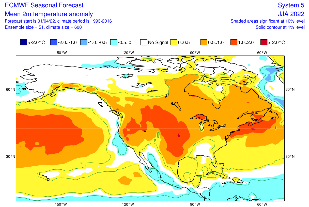
Warm anomalies are also forecast over much of central and eastern Canada, and also the northeastern United States. That region is under the influence of the high-pressure system in the region.
Normal to wetter conditions will prevail over northern Europe under the low-pressure zone. But the rest of the continent is expected to be quite drier than normal, creating a likely drought scenario.

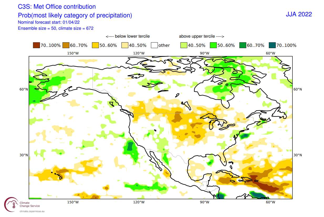
The precipitation forecast over North America shows drier conditions over most of the central and northern United States. But parts of the southeastern and southwestern United States, and eastern Canada have a higher chance of wetter conditions.

Combined with the strong warm temperature anomalies for the south-central United States, so far this looks to be a scorching/dry summer in development for south-central states and further up into the Midwest.
UKMO SUMMER LONG-RANGE FORECAST
Our second model of choice is the UKMO model, from the United Kingdom Met-Office. This has also been a good performer in the past seasons, so we usually include it in our standard “suite” of long-range model forecasts.
In the pressure pattern forecast from UKMO below, we can see also see the La Nina high-pressure system in the North Pacific. But this model has a high-pressure anomaly extending over the northern United States and southern Canada.
A high-pressure system is indicated over western Europe, with a low-pressure area over northern Europe. This is a similar pattern as in the ECMWF forecast.
The global temperature anomalies show the warm pooling over the northern half of the United States and southern Canada. That is the warmer airmass under the high-pressure anomaly.

Europe features warmer than normal conditions over much of the continent. The intensity reduces towards the north, where the influence of the low-pressure zone increases.
Looking closer at Europe, we see much warmer than normal weather over most of the continent. But the exception is far northern Europe, which will be close to the low-pressure zone and the polar jet stream.

Over North America, we can now better see the strong warm pooling over much of the central and northern United States. The far southern United States however does feature weaker anomalies, courtesy of the La Nina influence.
Warm anomalies are also forecast over central and eastern Canada, and also the northeastern United States.
Precipitation-wise, normal to wetter conditions will prevail over far northern Europe in the low-pressure zone. But the rest of the continent is expected to be quite drier than normal. There are neutral areas in central Europe, hinting at a likely active storm season. Most precipitation in Summer is from convection (storms).
The UKMO precipitation forecast over North America also shows drier conditions over most of the central and northern United States and southern Canada. And like the ECMWF it shows more likely wetter conditions over southwestern and eastern United States.
This is now the second model that basically shows a hot and dry summer for the central United States and also further up into the Midwest.
CFS SUMMER 2022 SEASONAL FORECAST
In contrast to the European models, we like to use the main North American long-range model, the CFS version 2 from the NOAA/NCEP in the United States.
The CFS model is close to the ECMWF, with a high-pressure system in the North Pacific and another separate zone over the northeastern United States. This is yet again a La Nina influence forecast in Summer.
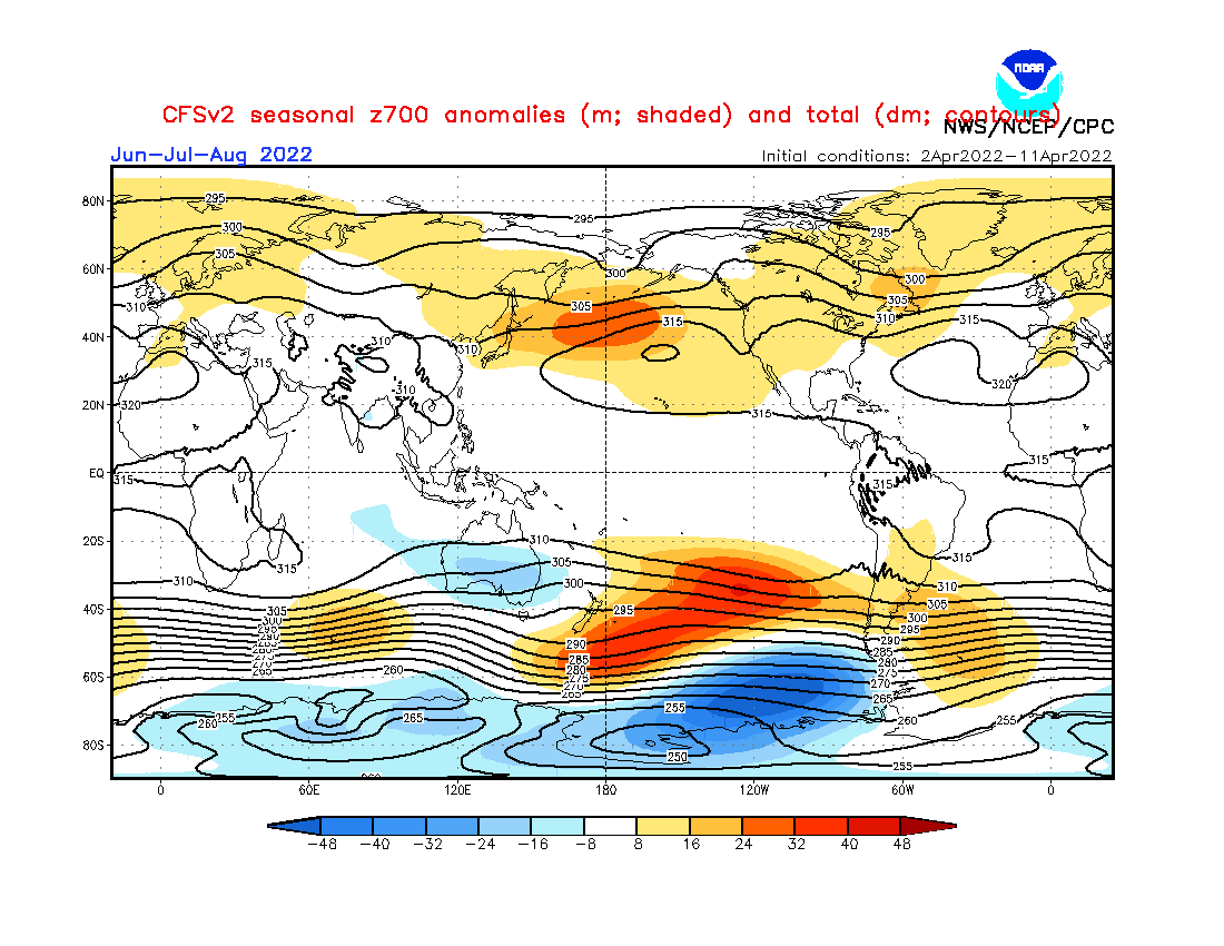
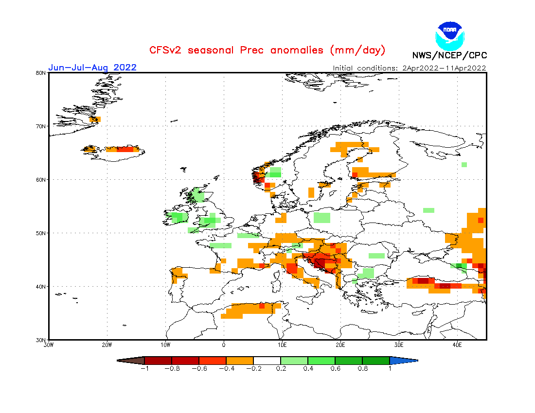
For Europe however, we see a different forecast than in the previous two models. Higher pressure is forecast over central and northern Europe, and a potential low to the west.
Global airmass temperatures are of course warmer than normal over much of the Northern Hemisphere. But some of it is due to the model averaging/bias and the long lead time. Tho there is still a pattern in this otherwise plain forecast.
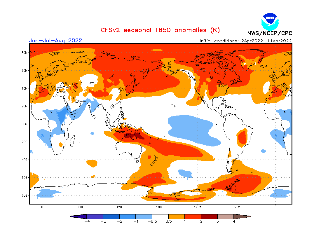
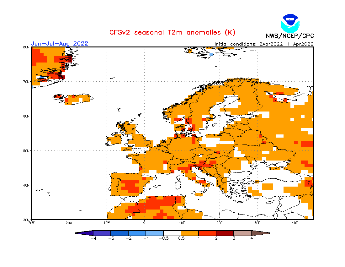
Looking closer at Europe, the surface temperatures are warmer than normal over most of the continent, especially central and western regions. A more likely scenario is the reduction of warm anomalies towards the far northern Europe.
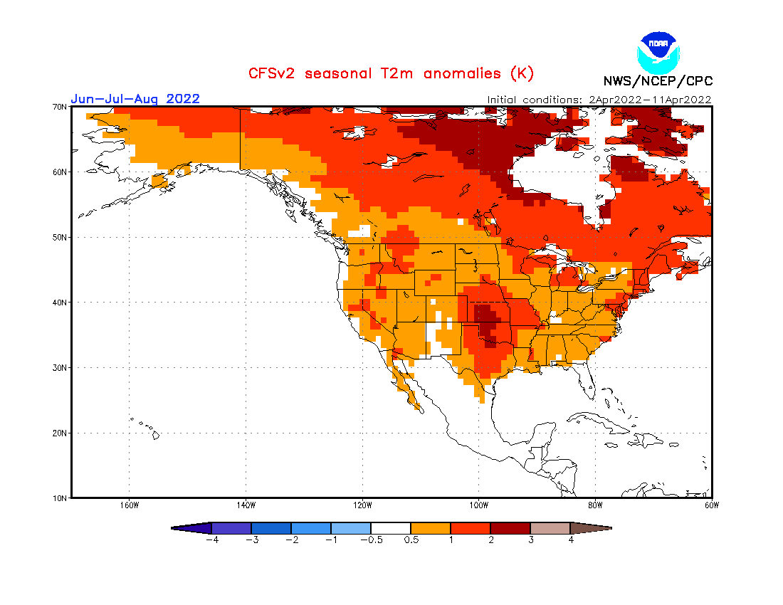
The North American temperature forecast below shows a similar pattern to the previous two models. The main core of the hotter Summer weather is forecast over the south-central United States. Stronger warm anomalies are also forecast for much of eastern and northern Canada.
Looking at precipitation in Europe, we see mostly drier Summer conditions across the continent. Wetter conditions are most likely for northwestern Europe, under the influence of the forecast low-pressure zone to the west.
Over North America, the United States shows the most deviation from normal in this forecast. Especially the south-central states are forecast to be much drier than normal.
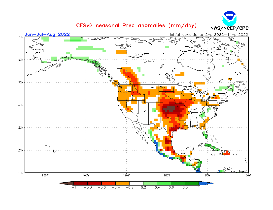
This is now a third model that is also forecasting a hot and dry summer across the south-central United States. This gives high confidence for this scenario, as different models come to a similar conclusion.
SUMMER 2022 EARLY WEATHER FORECAST – OVERVIEW
As reading images and descriptions can be quite confusing, we have put together a simple Summer forecast summary:
Europe is expected to have warmer/hotter than average summer over much of the continent, except for parts of northern and northwestern Europe.
There will still be cold fronts and severe weather events over central regions. The low-pressure area over northern Europe can send occasional cold fronts down from the north, increasing convective activity (storms).
Normal to wetter conditions are expected mostly over northern Europe. The British Isles and Scandinavia could have a more unsettled Summer, as the jet stream positions just north of these regions, bringing along a higher chance for stormy weather.
Drought summer conditions are increasingly likely over western and south-central Europe.
North America summer forecast looks to be scorching. Most of the northern and south-central United States is expected to have a hotter summer than normal. Above-average temperatures are also forecast for the northeastern United States and over central and eastern Canada.
Especially in the south-central United States, there is a high-confidence forecast for a drier summer. Along with hotter temperatures, this is a concern for severe drought conditions.
The Southern United States also has a warmer summer signal. But at the same time, the precipitation forecast shows normal to wetter conditions across the southwest, and partially over the eastern United States.
Overall, hot and dry summer is expected across the south-central United States in this first long-range outlook. Over the southwest and east, more storms are expected, as the forecast calls for higher temperatures and normal to above-normal precipitation.
Looking at the NOAA official Summer temperature outlook, most of the United States is warmer than normal. The core warm anomalies are so far focused on the western half of the United States. This is the outlook from late March, as the April outlook has not yet been released.

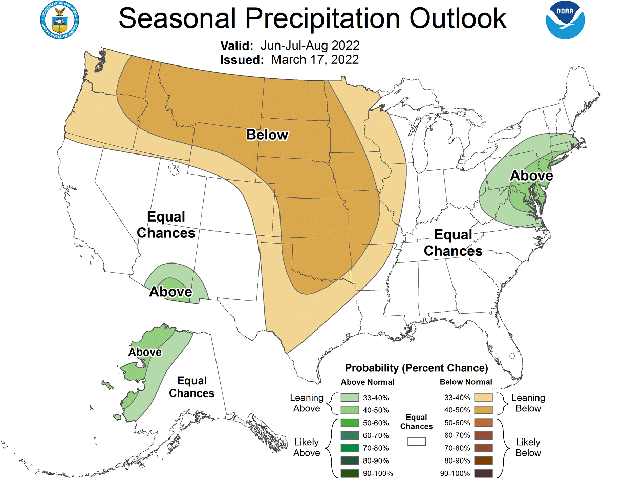
The official Summer precipitation forecast is quite similar to the model forecast. We see an equal-to-higher probability for more precipitation over the northeast and parts of the southwestern United States. But most of the northwestern and central United States is forecast to have a drier summer season.
The problem with precipitation in any La Nina season is typically the persistence of drought conditions in the southern and western United States. Below we have the latest drought analysis from NOAA, which shows the current drought conditions across the United States.

Most of the western half of the United States is under some level of drought conditions. The driest conditions prevail in the southern and northwestern United States. A hot and dry summer, as currently forecast for the south-central and northwestern states, will worsen the drought conditions.
We will release regular updates as fresh forecasts and data are available. So make sure to bookmark our page. Also, if you have seen this article in the Google App (Discover) feed, click the like button (♥) there to see more of our forecasts and our latest articles on weather and nature in general.
SEE ALSO: