The collapse of the Polar Vortex has shaped the weather in the past weeks. But now the latest forecasts show that these effects are diminishing quickly. New weather patterns will develop in the month of May over North America and Europe, significant also for weather development into Summer.
The Polar Vortex is a very powerful short-to-medium range weather driver. For this reason, we monitor its activity high above in the stratosphere. The Polar Vortex underwent a strong collapse event in March, with the effects lasting for a few weeks.
We are now seeing a forecasted shift in the weather patterns, starting to set a tone also for the coming Summer.
RISE AND FALL OF THE POLAR VORTEX
Every year as we head into autumn, the polar regions receive less and less sunlight. With less solar energy, cooling begins over the north pole.
But as the polar temperatures drop, the atmosphere further south (towards the equator) is still relatively warm as it continues to receive light and energy from the Sun.
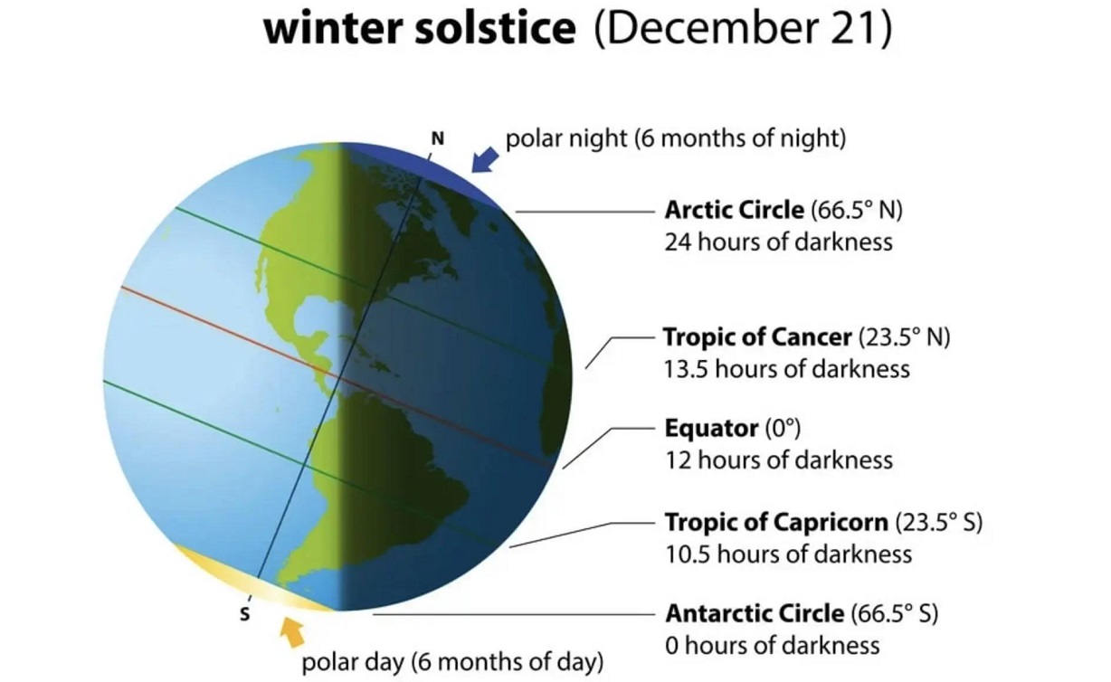
You can see the winter solstice in the image below. The polar regions receive little to zero solar energy, compared to regions further south, which still continue to receive plenty of sunlight and warmth.
But, as temperature drops over the polar regions, so does the pressure. With colder temperatures over the pole, the temperature difference towards the south increases.
This causes a strong global pressure difference from the poles to the equator, and a large low-pressure (cyclonic) circulation starts to develop across the Northern Hemisphere. It extends from the surface layers, far up into the stratosphere. This is known as the Polar Vortex.
We produced a 3-dimensional model of the Polar Vortex, extending from the lower levels up into the Stratosphere. The vertical axis is enhanced for visual purposes. You can see in the image below what the actual structure of the Polar Vortex looks like.
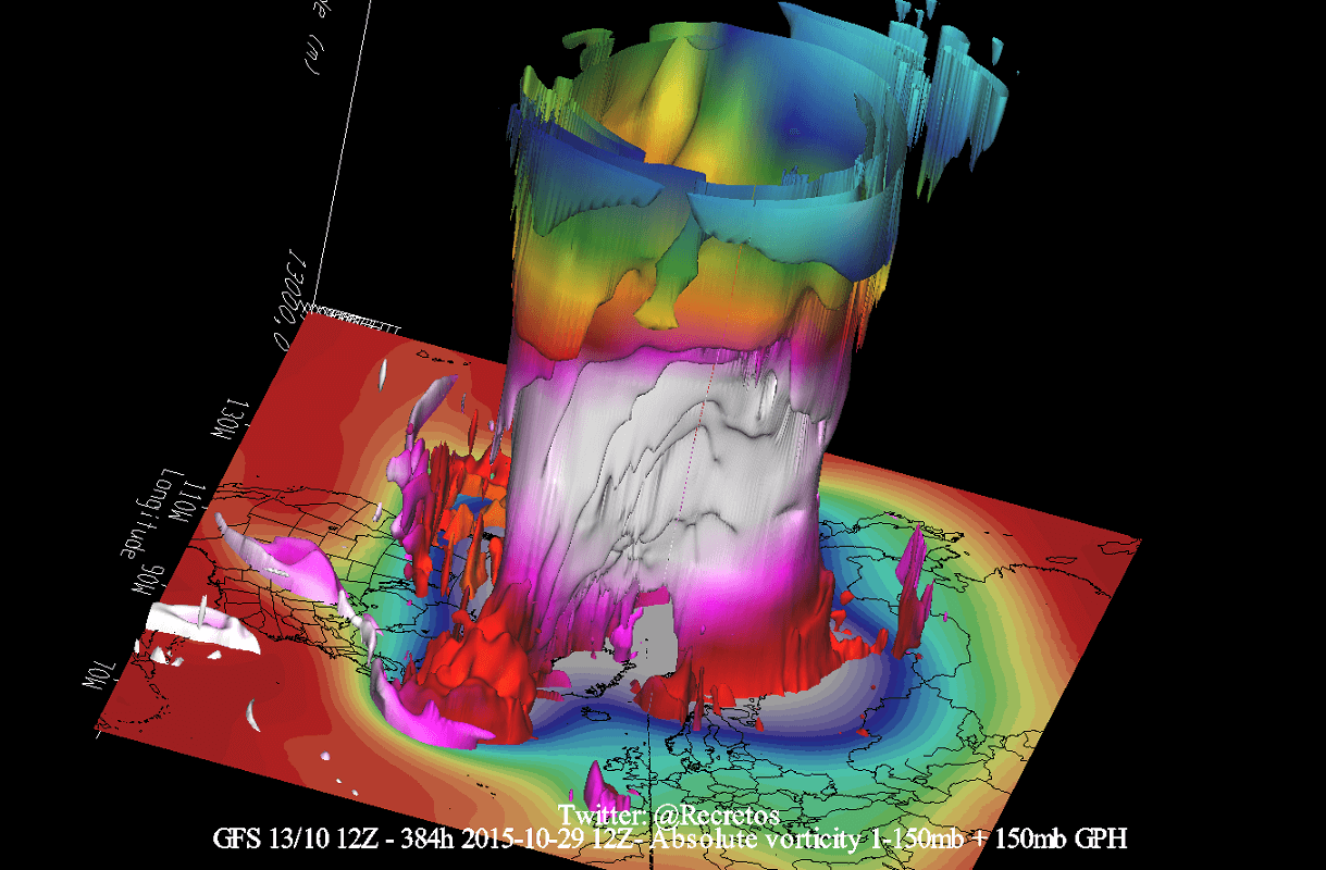
The Polar Vortex behaves like a very large cyclone, covering the whole north pole, down to the mid-latitudes. It is connected through all atmospheric levels, from the ground up, having different shapes at different altitudes.
In the next image below, we have the bottom end of the polar vortex at around 5km/3miles. The closer to the ground we go, the more deformed the polar vortex gets because it has to interact with the rough terrain over the continents.
Be aware of its cold “arms” extending into the lower latitudes, bringing along colder air and snowfall. These arms also pack a lot of energy and can create strong winter storms, like a Noreaster’ in the United States or powerful cyclones in the North Atlantic.
We are typically focusing more on the Stratospheric Polar Vortex, as it plays a very important role in the weather development throughout the season. It is known for its strong influence down from the stratosphere.
A strong Polar Vortex usually means strong polar circulation. This usually locks the colder air into the Polar regions, resulting in milder seasonal conditions for most of the United States and Europe.
In contrast, a weak Polar Vortex can create a disrupted jet stream pattern. It has a much harder time containing the cold air, which can now escape out of the polar regions, into the United States and/or Europe. Image by NOAA.

Typically, a polar vortex circulation is disrupted due to a rise in temperature and pressure in the stratosphere. That is called a stratospheric warming event, which can disrupt or even collapse the Polar Vortex.
To put everything into a perspective, we produced a high-resolution video, which shows the recent collapse event of the Polar Vortex. We can see the Polar Vortex first being split apart, followed by a strong displacement and disintegration.
The main takeaway from the video is that the Polar Vortex is not just one single winter storm or a cold outbreak that moves from the Midwest into the northeastern United States.
It is a large cyclonic area that is spinning over the entire Northern Hemisphere, from the ground up to the top of the stratosphere, reaching over 50km/31miles in altitude.
POLAR VORTEX COLLAPSE
We typically use the 10mb level, when analyzing the polar vortex in the stratosphere. That 10mb level is found around 30km (17-20 miles) in altitude.
This layer is considered to be in the mid-stratosphere and is generally a good representation of the strength and status of the stratospheric polar vortex.
The strength of the polar vortex is most often measured by the power of the winds that it produces. This is done by analyzing the westerly zonal (west to east) wind speeds around the polar circle (60°N latitude).
In the image below we have the seasonal average zonal wind speed for the Polar Vortex at 10mb level. The black line is the long-term average, and the blue line is the analyzed polar vortex strength in the last cold season.
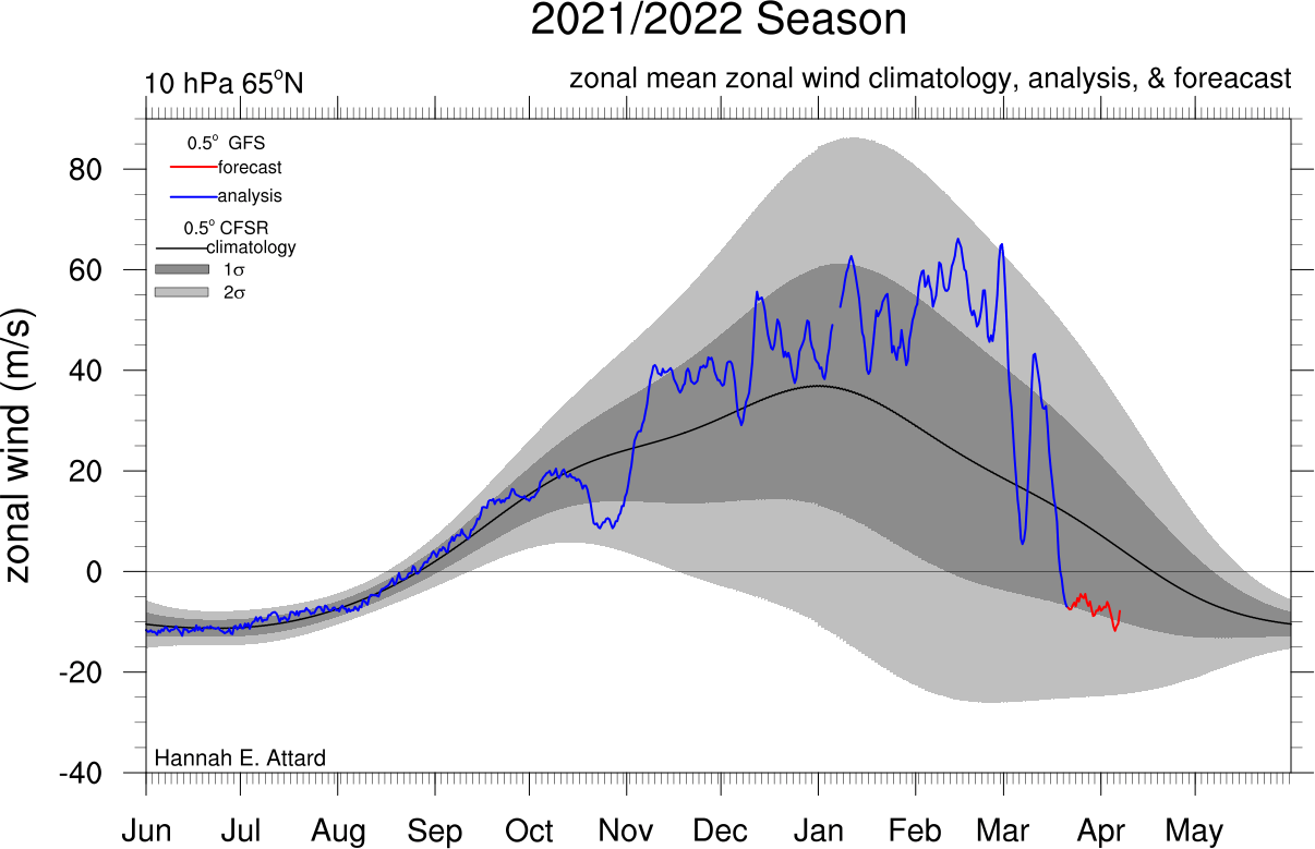
For the majority of the cold season, the polar vortex was strong. But in March we can see the rapid collapse of the polar vortex. When the zonal (westerly) winds are reduced below zero in a sharp/rapid event, that is considered a breakdown of the circulation.
But besides winds, the temperature is also of major importance. The colder the polar vortex gets, the stronger it becomes.
Below we have the 2021/2022 season analysis of the stratospheric temperature at 10mb from NASA. The red/pink line is the 21/22 season, which shows the colder than normal polar vortex at the 10mb level in the stratosphere during Winter.

But notice the pink line, which shows a rapid temperature rise in March. You can see three distinct warming waves, each stronger than the last one. The final “strongest” peak, has produced the breakdown of the Polar Vortex.
But what exactly was happening up in the higher levels of the atmosphere? And how can it influence our weather at the surface?
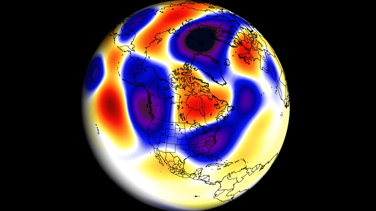
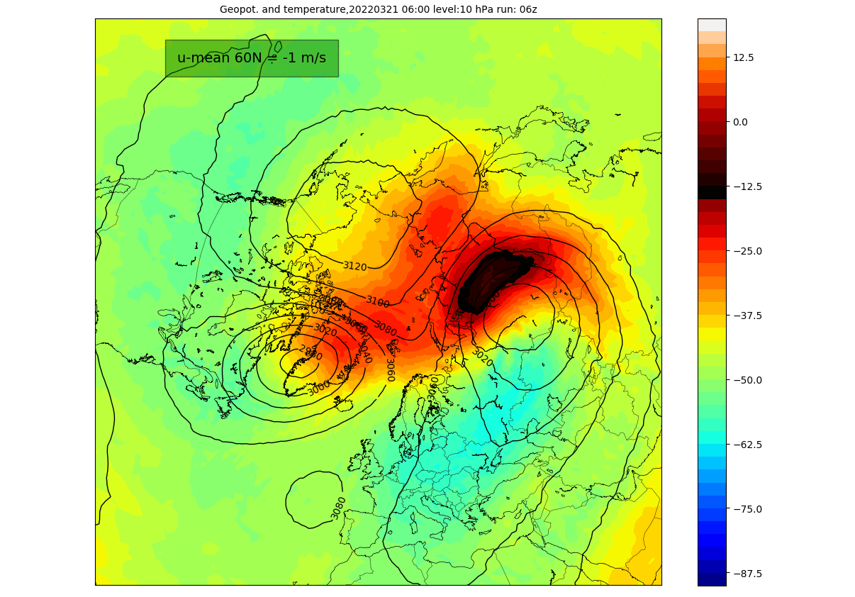
Looking at the polar vortex in mid-March below, we can see the vortex was already under pressure from the North Atlantic and the North Pacific sectors. It had an oval shape, with an ongoing core separation, creating two centers within the circulation.

Taking a look at the temperatures at the 10mb level (30km/18.5mi), we can see a warming wave developing over eastern Siberia and a weaker one over northern Canada. Here we can also see the further separation of the polar vortex into two distinct cores.
The collapse process can also be seen below in the 3D structure of the polar vortex. The vortex at this point was breaking down, developing two cores, as seen in the previous images.

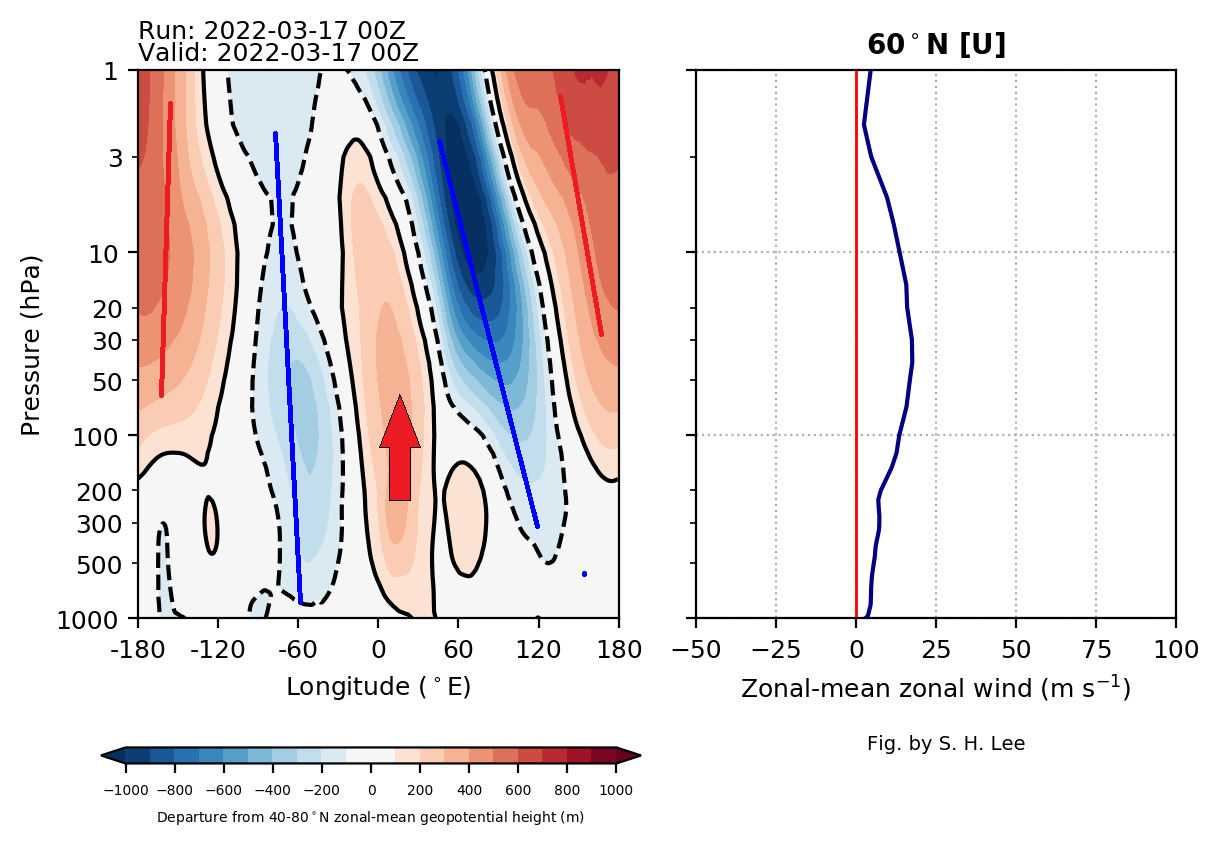
The vertical pressure anomaly reveals a connection between the stratosphere and the lower levels. It shows the stratospheric low-pressure areas separated into two separate cores in mid-March. A strong high-pressure area extends from the surface up into the stratosphere.
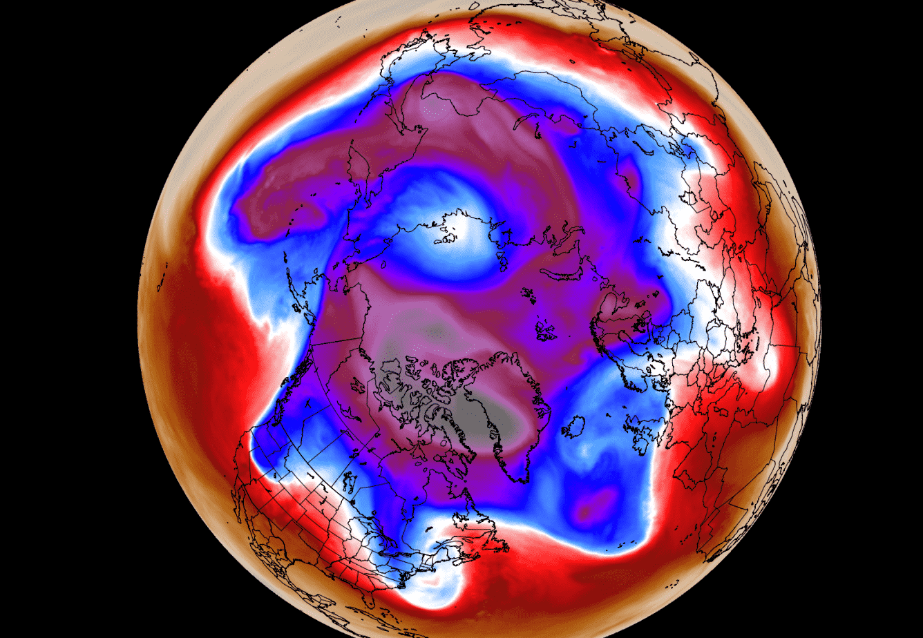
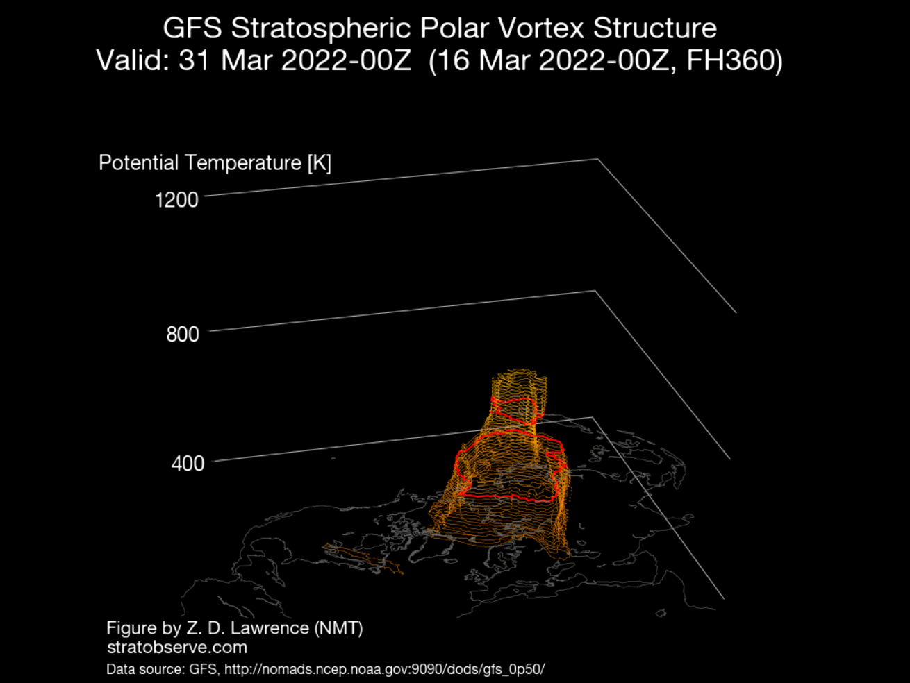
Early this month, the polar vortex was defeated, and the polar circulation reversed. The remains of the stratospheric polar vortex were pushed over the eastern north hemisphere, with a high-pressure system taking over the stratosphere.

The 3D structure reveals that only the lower level circulation remained of the whole polar vortex circulation. The upper stratospheric part of the polar vortex is now gone until the next cold season 2022/23 begins in Fall.
The influence of such an energetic event can be seen below. This graphic shows the vertical temperature anomaly. We can see the three warming waves, coming down from the upper stratosphere.
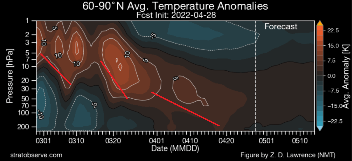
The final warming event can now be seen leveling off, forecast to stabilize in the upper levels of the troposphere.
As you will see now, we can track these stratospheric events to the lower level circulation. That means that it effectively also influences the weather that we feel.
NEW MONTH, NEW WEATHER
This first graphic is probably the most important in this story. It shows the vertical pressure anomaly from the surface up into the upper stratosphere. The red arrows mark the Polar Vortex collapse process, influencing down to the surface levels.
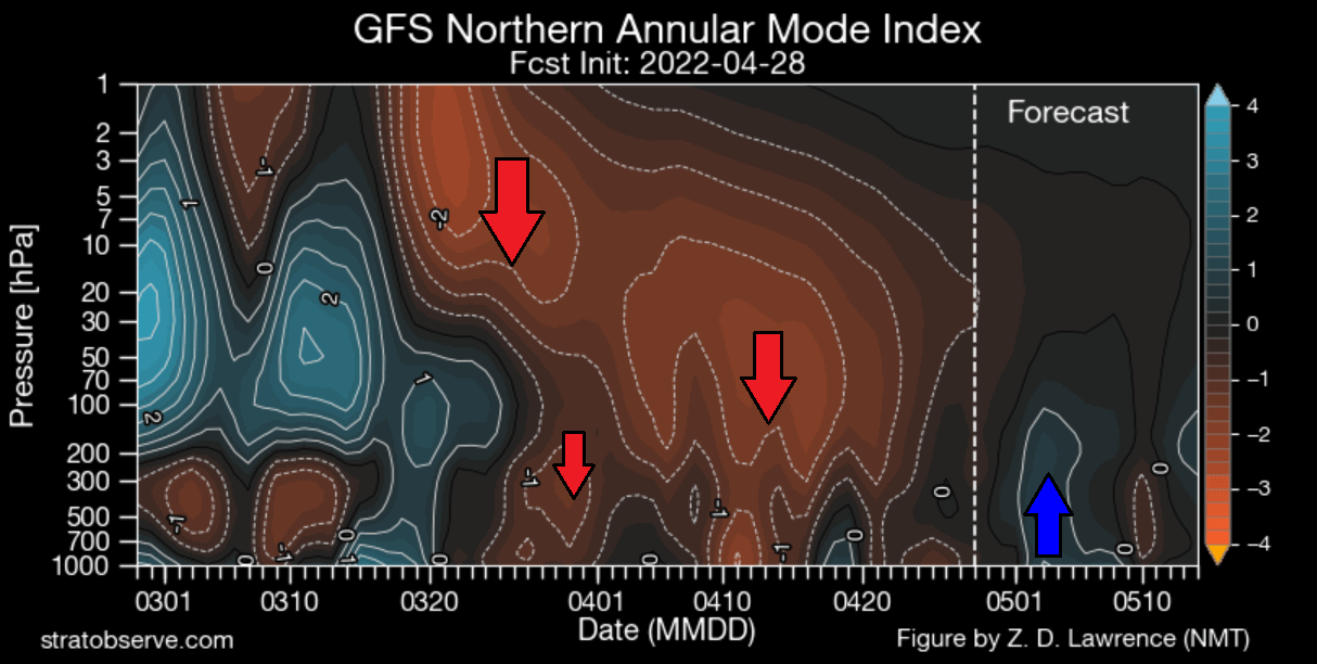
We can see by the arrows, that the high-pressure anomaly resulting from the collapse propagated down. It connects to the weather patterns, most strongly in mid to late April. But the effect of the Polar Vortex collapse is now starting to subside.
But can see a positive upward anomaly forecast at the beginning of May. That coincides with a positive phase of the AO, seen in the forecast below.

AO stands for the Arctic Oscillation index, explaining the pressure pattern and circulation over the North Pole. A positive phase means a stronger and more stable lower level polar circulation.
This is a strong sign of the subsiding polar vortex collapse effect. We can see the shifts between the positive and negative sides from late March and over the course of April. Fluctuating due to the polar vortex collapse after-effect.
The weather pattern at the beginning of the month can be seen below and is showing low-pressure anomalies over the polar regions. The low-pressure returning to the pole is the reason the AO index is rising into the positive phase. This amplifies the polar circulation.

But we are in mid-Spring, so this can have a different effect than in mid-winter. We can also see a ridge over eastern Canada and the United States. Another low-pressure area is over Alaska.
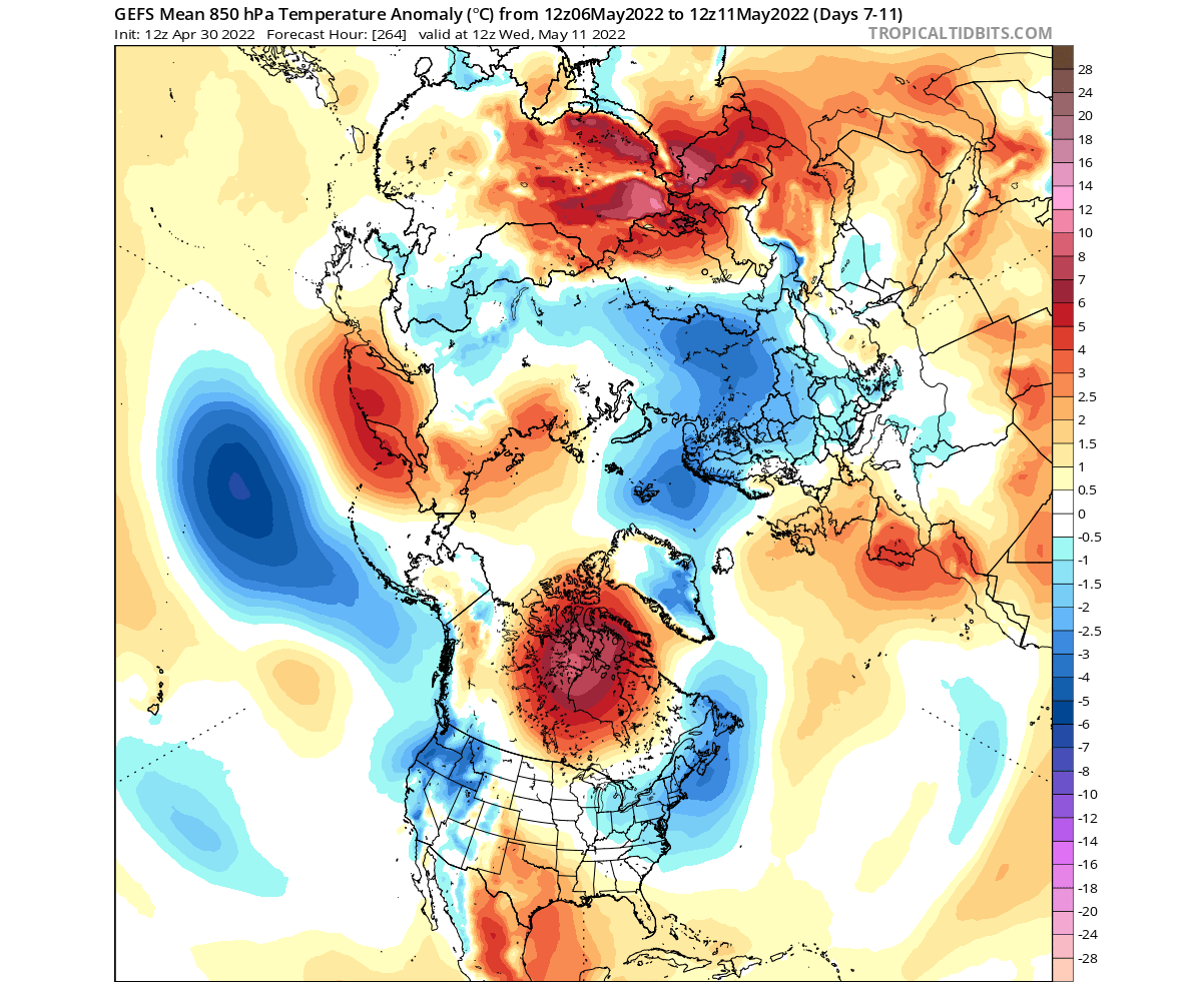
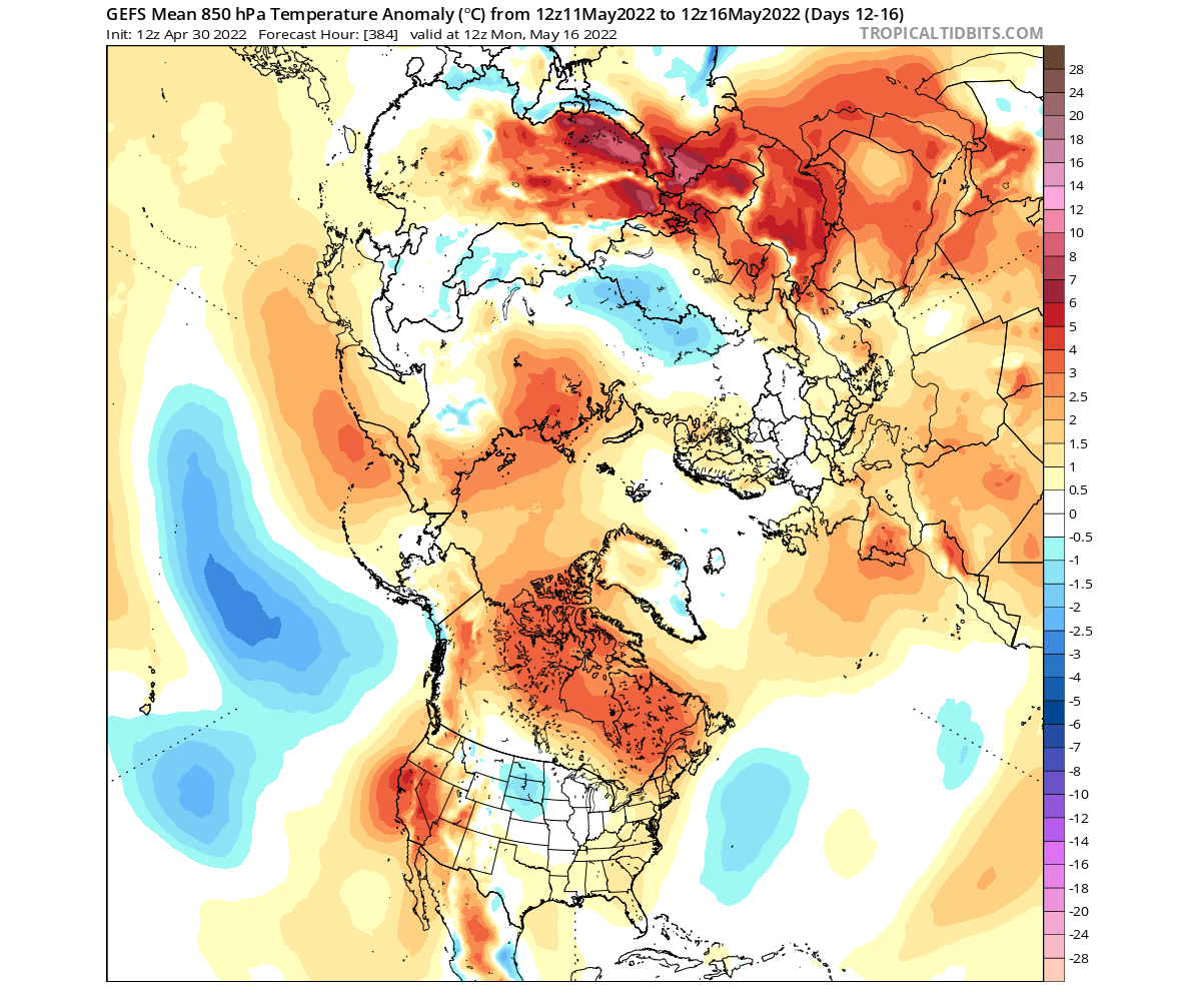
Such a pattern at the beginning of the month will provide colder than normal air into northern and parts of central Europe. Warmer than normal weather will prevail over southern and southeastern United States, while a cold front moves over the Midwest.

Taking a closer look at this cold front over the United States, we can see the colder than normal temperatures spreading from the Midwest down towards the south. Warmer temperatures will prevail over much of the southeastern United States.
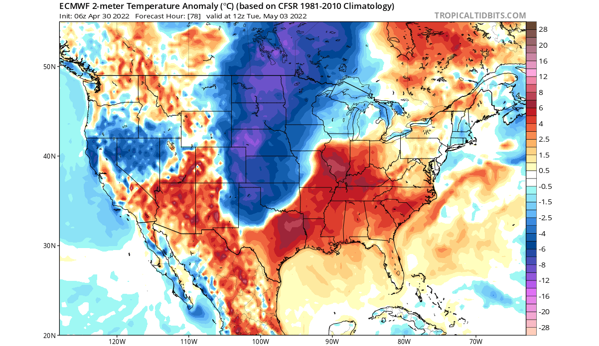
The air will be cold enough to bring some snowfall into South Dakota and Nebraska. Also, the higher elevations in the Rockies still tend to get fresh snowfall during this time of the year.

MID-MONTH WEATHER PATTERN
Going into the 2nd quarter of the month, we will witness a slight adjustment of the pattern. The positive AO index low-pressure system will remain over the polar regions. But a ridge will set up over Canada, with one low-pressure trough leaving and one entering the United States.
Overall the pressure pattern over Europe is expected to remain stable during this period.
The temperature forecast for this period shows the cold air following the strong low-pressure areas in the western and eastern United States. Warmer temperatures will remain over the southern United States, and we have warm anomalies over central Canada in the forecast.
Warmer weather will also expand over western Europe, as colder conditions remain further to the east.
Looking closely at this period over the United States, we can see colder than normal air spilling down over the northwest. Another cold anomaly area is over the eastern United States, in the wake of the outgoing low-pressure system.
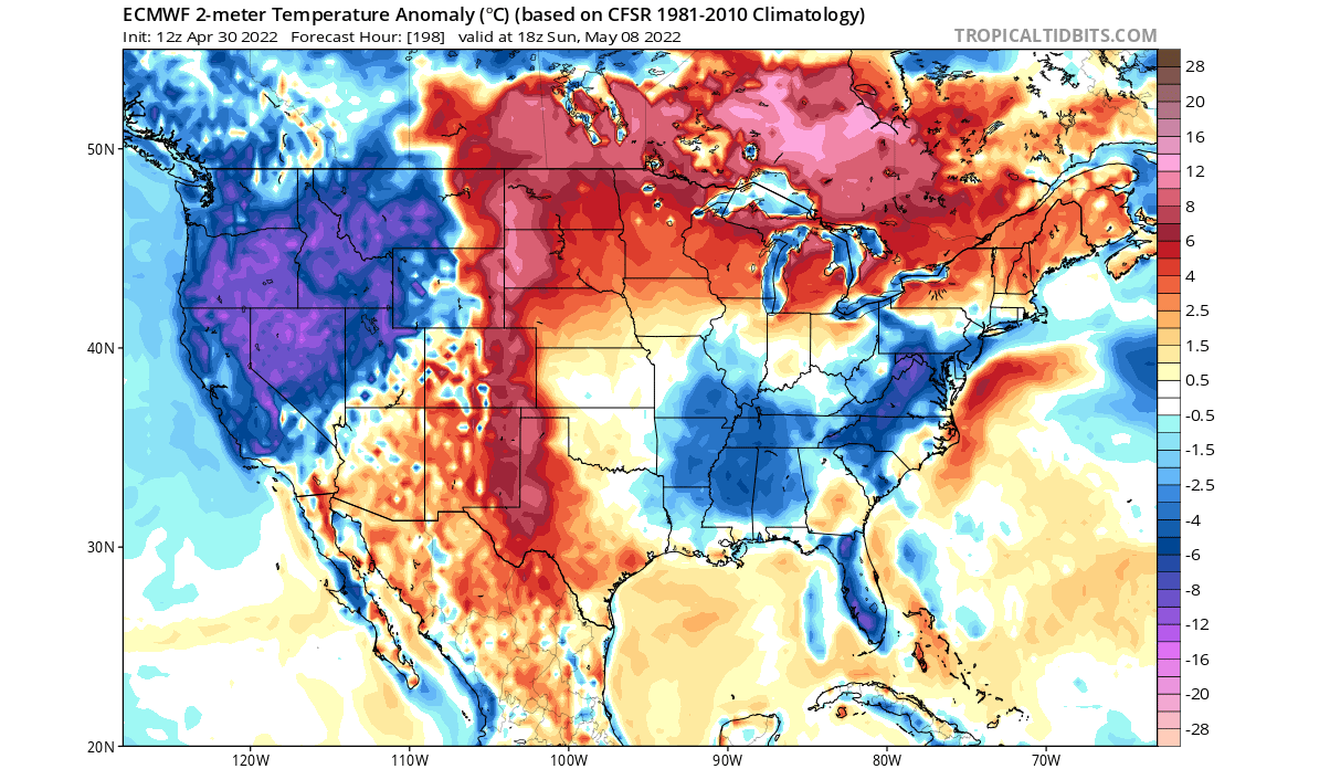
In-between the low-pressure system we have a zone of warmer than normal temperatures. It is expanding from the southern United States over the Midwest and into Canada.
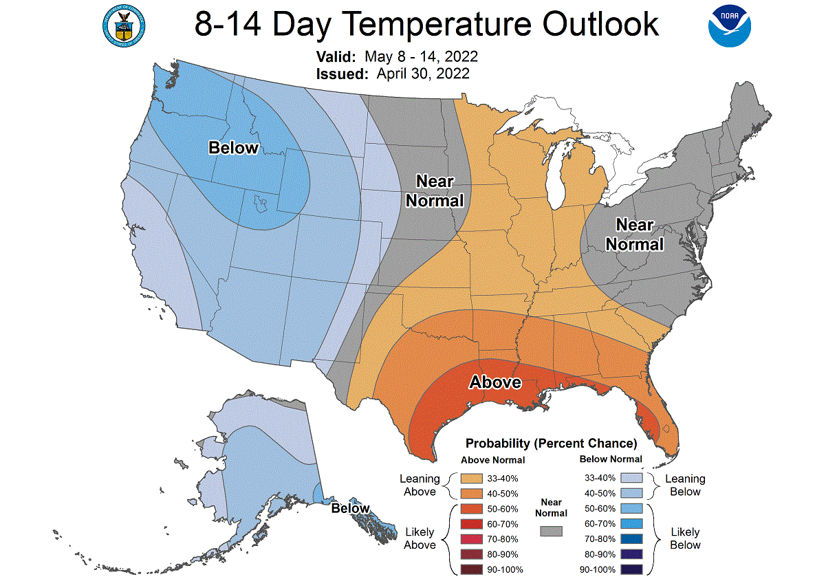
NOAA OFFICIAL 8-14 DAY WEATHER OUTLOOK
This is all nicely captured below on the official NOAA/CPC 8-14 day weather forecast. Colder than normal temperatures will prevail mostly over the western United States, as low-pressure systems are present on both sides of the country. Warmer temperatures are forecast for the southern United States, expanding to the north.
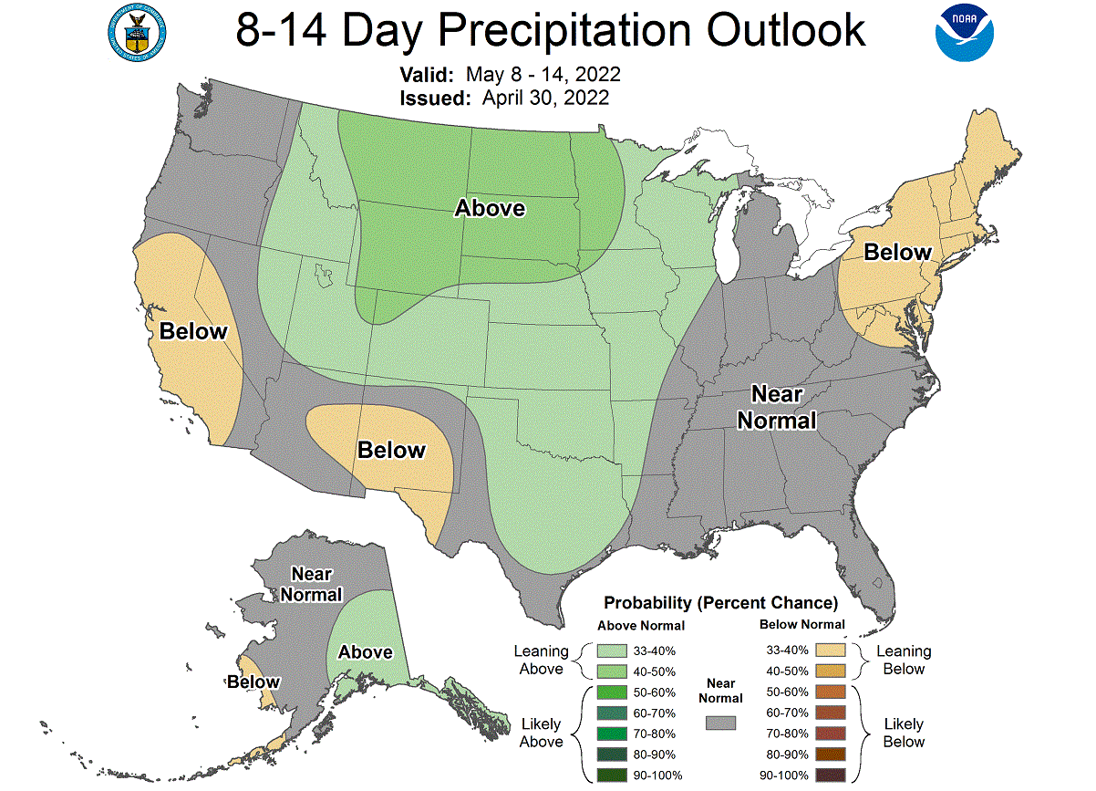
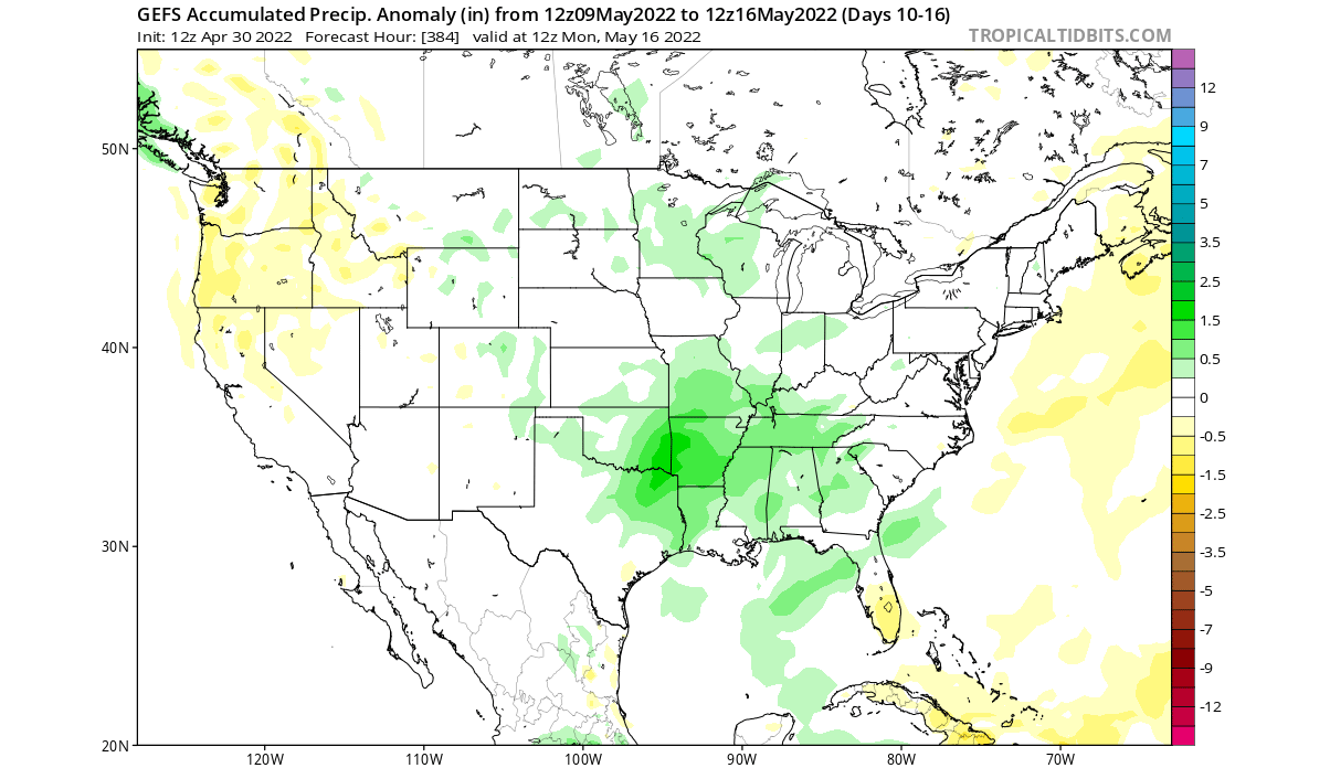
Looking at the official NOAA precipitation forecast, we have a trend for more precipitation over the northern and south-central United States. Less precipitation is forecast for the northeastern and southwestern United States.
WEATHER PATTERNS EVOLVE IN LATE MONTH
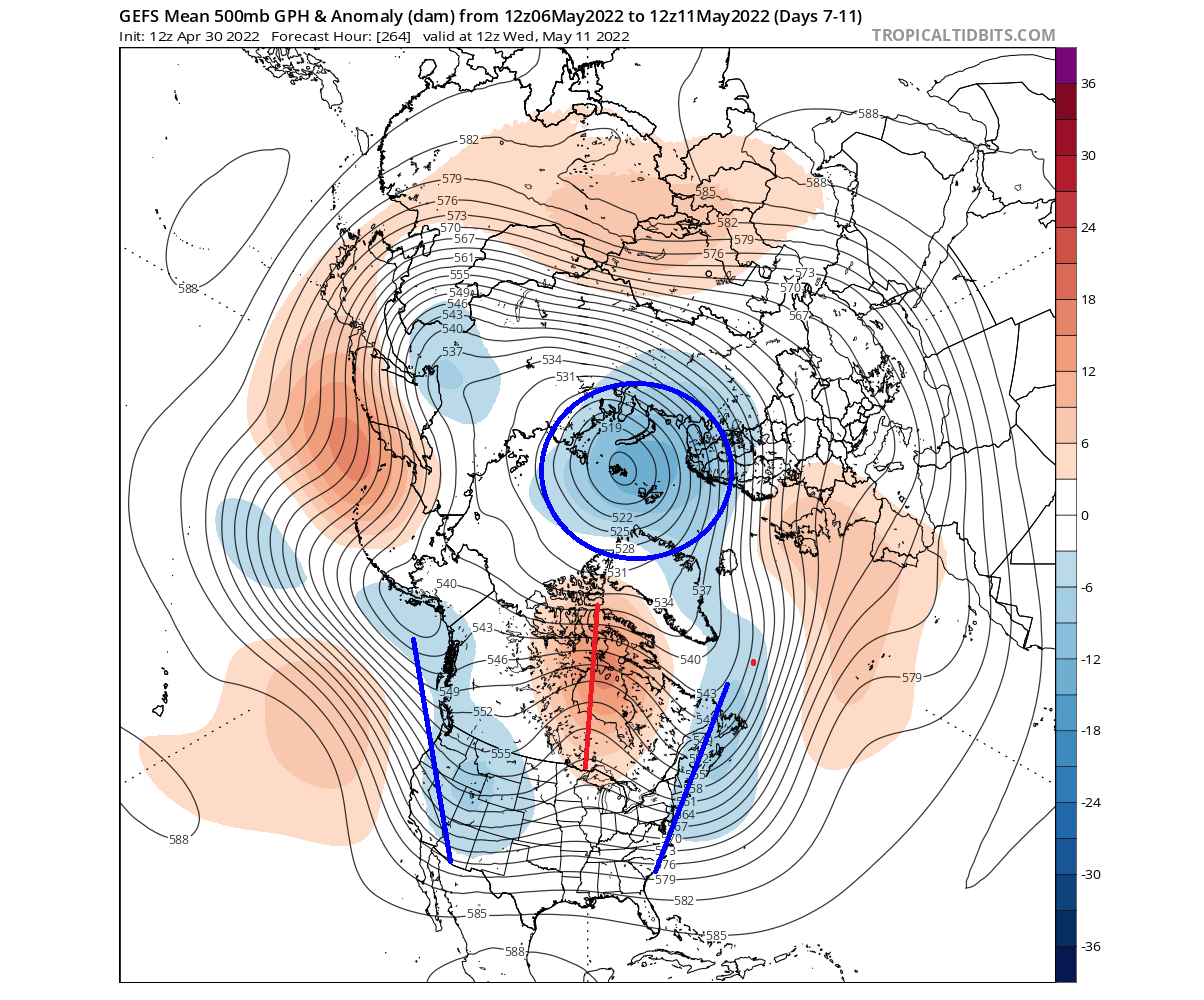
Looking into the second half of the month, the low-pressure area remains around the polar circle. But the pattern reverses in the United States. The low-pressure system advances from the western United States into the central area, now being replaced by two ridges on the west coast and the east coast.

At the same time, a ridge also remains over western Europe. It will keep most of the western and central Europe in normal to warmer spring temperatures.
Over North America, we can see an extensive warm anomaly remaining over Canada. But warmer anomalies are forecast to appear over the western and eastern United States, replacing the cold anomalies from the previous week.
Looking closer at the United States pattern, we have an example forecast below, showing a possible scenario. The idea is that the low-pressure system will move into the central United States, bringing along a cold front.

At the same time, warmer temperatures will remain under the ridge in the western United States. To a lower extent than in the west, warmer temperatures are also expected for the far eastern United States.
The precipitation anomaly forecast below shows the cold front likely advancing from the Midwest down into the south-central and the southeastern United States. This pattern does support severe weather events, so it will be monitored closely, as the period gets closer.
We do have to repeat, that this is further out in the forecast period, so it serves as an example of a possible scenario. The ensemble forecast supports this solution, which is the basis for weather forecasting at this range.
LATE MAY WEATHER PATTERNS
The latest extended-range forecast from ECMWF was released this Thursday, so we can look at some May second-half forecasts.
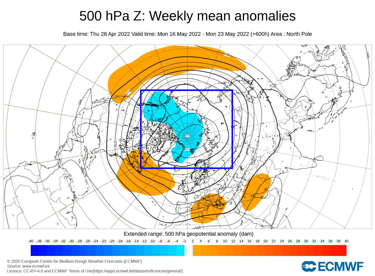
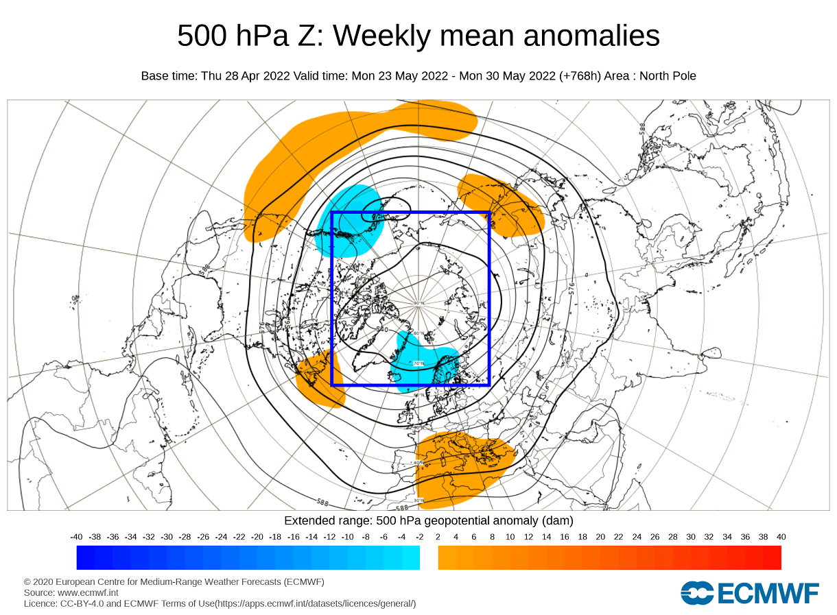
The pressure pattern forecast for late mid to late May shows lower pressure over the polar regions. This will keep most of the coldest air close to the polar circle. High pressure is forecast over the western United States, eastern Canada, and southern Europe.
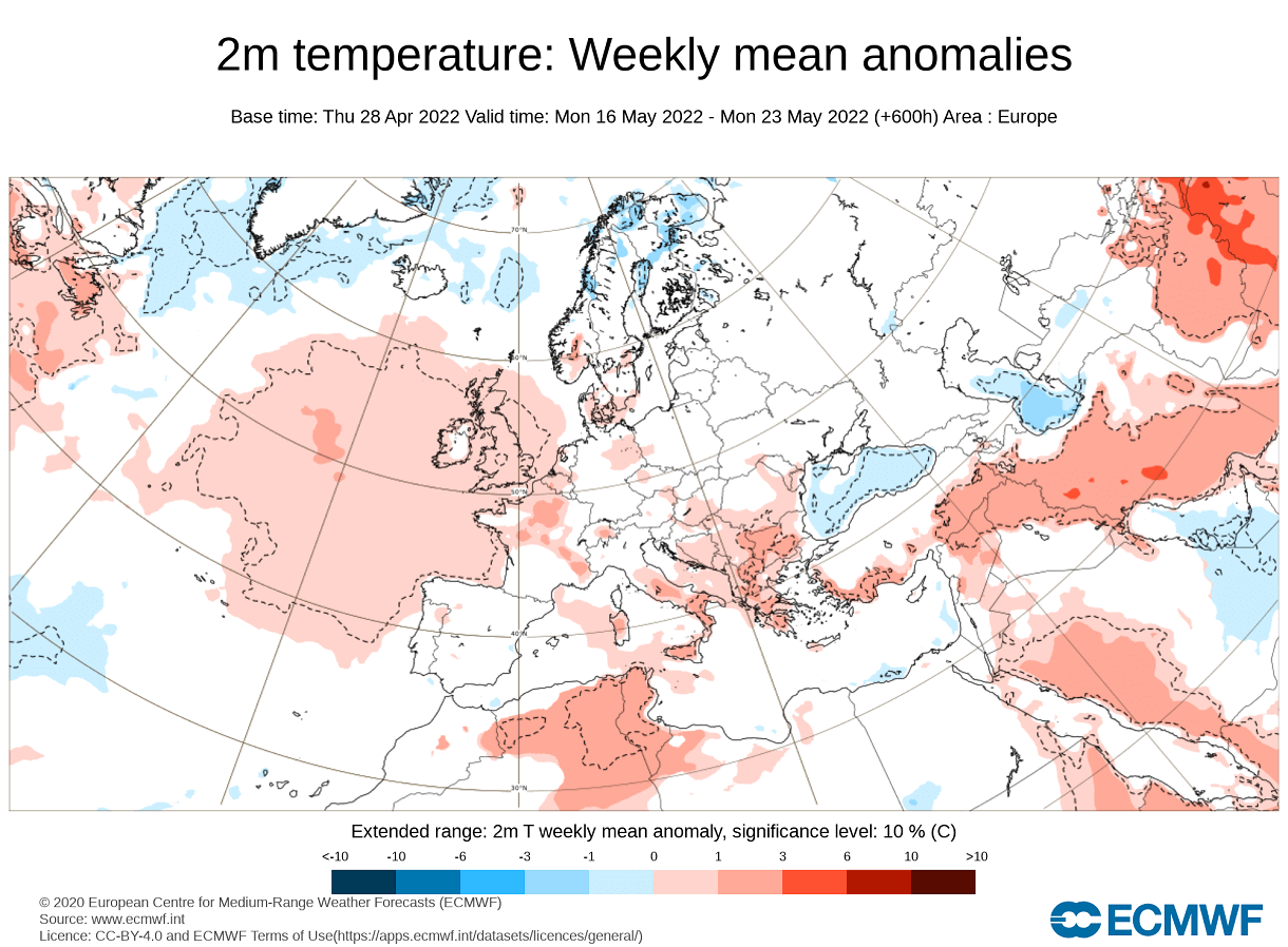
Looking at the temperature forecast for Europe in the same period, we can see mostly warmer than normal temperatures. Colder than normal air is forecast to remain mostly over Scandinavia.
The temperature forecast for North America shows the colder temperatures remaining mostly in far western Canada. An extension is likely into the northwestern United States. Southwestern and northeastern United States and eastern Canada are expected to be warmer than normal.
Going towards the end of the month, the high-pressure zones remain in place. But we have a better signal for low-pressure areas in western Canada and northern Europe. Some of this could also be the ensemble forecast averaging in the extended period.
Temperatures for this period over Europe remain warmer than normal. Cold anomalies are reserved for the northern parts of Scandinavia.

Over North America, we can see the colder anomalies remain over western Canada. Warmer anomalies are now extending further to the north into the Midwest. Southwest and the east coast of the United States are also forecast to be warmer than normal.

NOAA/NCEP also issues weekly weather forecasts, produced by their CFSv2 model. Below is the temperature anomaly forecast for mid to late May in the extended range.
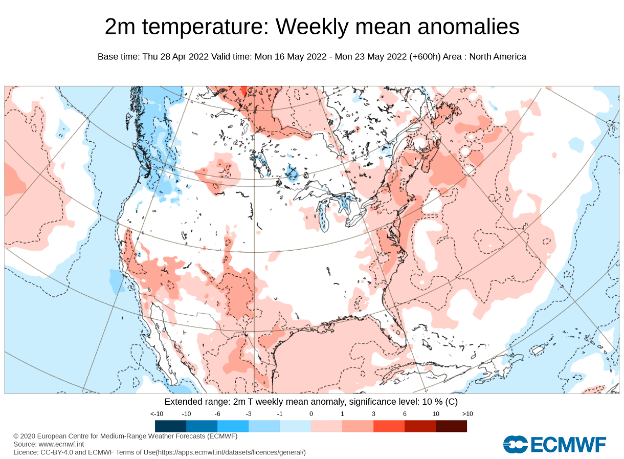
The mid-May forecast on the left shows the colder air over western parts of the United States and warmth in the east. Going into late May, we have the hints of a cold front coming down from the northwestern United States. During this time, strong warm anomalies are forecast for Canada.

May is the last month of Spring. So for this reason, we will take a look at the next weather season, Summer.
SPRING TO SUMMER SEASONAL OUTLOOK
We will look at the early seasonal trends for Summer 2022, using the ECMWF forecast. The period in question is the meteorological summer season, covering the June-July-August period.
We typically use the ECMWF for long-range forecasting, which is often referred to as the most reliable model in the long-range category. In reality, a lot can change with the individual year/season.
In the pressure pattern forecast from ECMWF below, we can see a La Nina high-pressure system remaining in the North Pacific. It extends over the western/northern United States.

A stronger high-pressure area is found over the northeastern United States. This will have a regional effect on the weather development in the eastern United States and also over eastern Canada under a separate high-pressure area.
Another high-pressure system is over western Europe, with a low-pressure area hinted over northern Europe.
The global temperature distribution also shows the La Nina pattern. Over North America, we see the warmest anomalies over the central and northern United States. That is the warmer airmass under the high-pressure anomaly. Warm anomalies also extend over much of southern and eastern Canada.

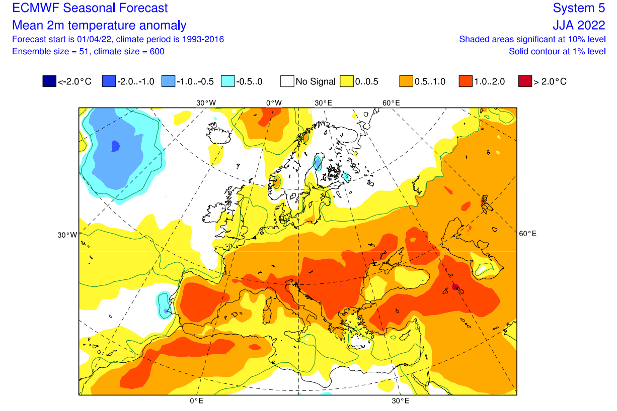
Europe features mostly warmer than normal conditions over the entire south-central half. Northern regions however are seen neutral, under a likely cooler low-pressure area.
Looking closer at Europe, we see much warmer than normal weather over most of the continent. But the forecast exception is northern Europe, expected to be under the influence of a low-pressure system.
Over North America, we now have a better image of the warm anomalies over much of the central and western United States. The southeastern United States however does feature a neutral area, similar to the historical La Nina summer pattern.

Warm anomalies are also forecast over much of central and eastern Canada, and also the northeastern United States. That region is forecast to be under the influence of the high-pressure system in the region.
Normal to wetter conditions will prevail over northern Europe under the low-pressure zone. But the rest of the continent is expected to be quite drier than normal, forecasting a drought scenario.

The precipitation forecast over North America shows drier conditions over most of the central and northern United States. But parts of the southeastern and southwestern United States and eastern Canada have a higher chance of having wetter than normal summer.

This is somewhat in line with the Summer La Nina influence, where the east and the southwestern United States can have more precipitation. The drier zones move into central and northern regions.
Overall, hot and dry summer is expected across the south-central United States in this long-range outlook. Over the southwest and east, more storms are expected, as the forecast calls for higher temperatures and normal to above-normal precipitation.
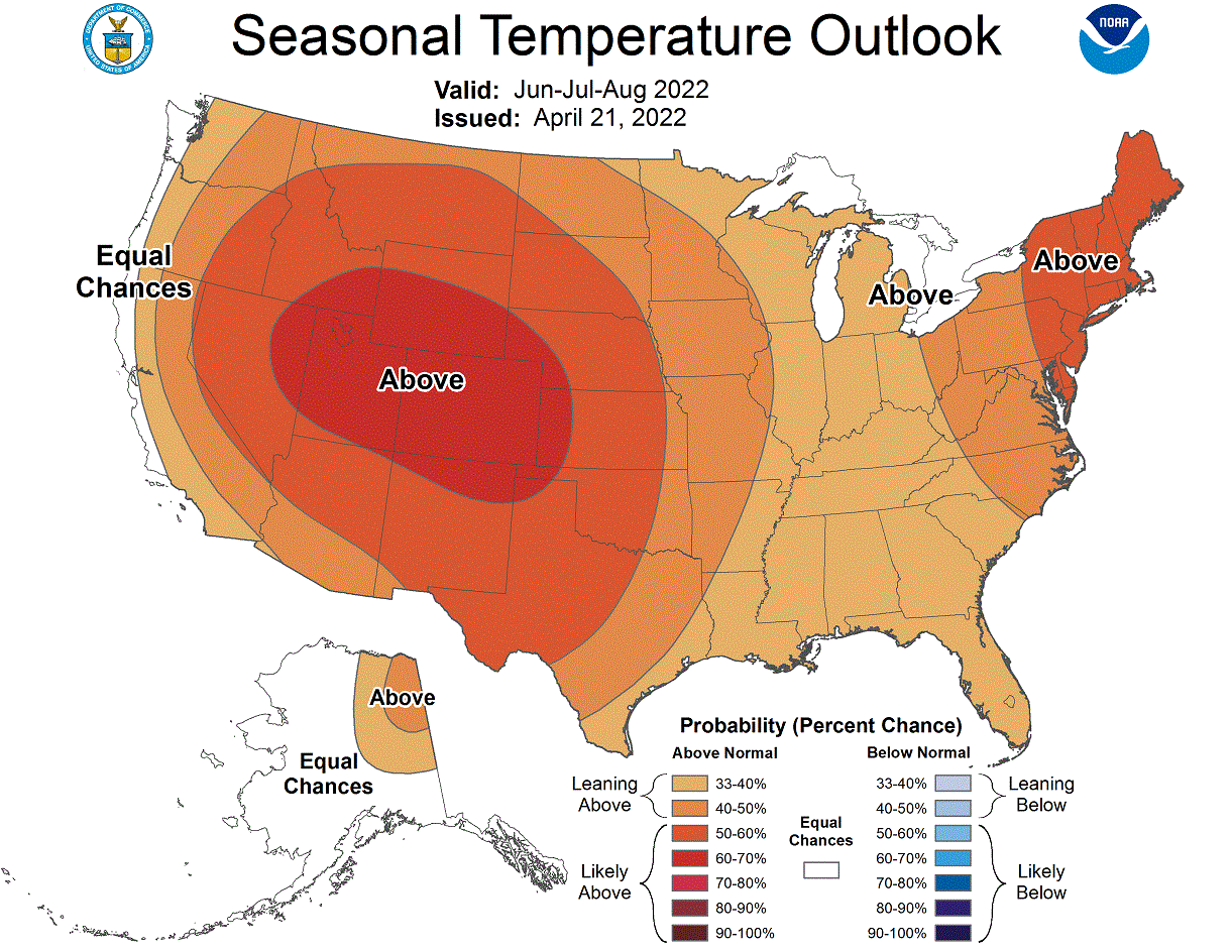
Looking at the NOAA official Summer temperature outlook, most of the United States is warmer than normal. The core warm anomalies are so far focused on the western half of the United States and some on the far northeast.
The official Summer precipitation forecast is quite similar to the ECMWF forecast. We see an equal-to-higher probability for more precipitation over parts of the east and over the southwestern United States. But most of the northwestern and central United States is forecast to have a drier summer season.

The problem with precipitation in any La Nina season is typically the persistence of drought conditions in the southern and western United States. Below we have the latest drought analysis from NOAA, which shows the drought conditions across the country.

Most of the western half of the United States is under some level of drought conditions. The driest conditions prevail in the southern and northwestern United States. A hot and dry summer, as currently forecast for the south-central and northwestern states, will worsen the drought conditions.
We will release regular weekly and monthly updates on weather development, so make sure to bookmark our page, and also, if you have seen this article in the Google App (Discover) feed, click the like button (♥) there to see more of our forecasts and latest articles on weather and nature in general.
SEE ALSO: