A very dramatic weather pattern change is coming up for the Easter holidays this year. A historic Arctic cold blast will impact the UK and Ireland first, then spread towards central Europe and the Mediterranean early next week. Massive snow with blizzard conditions will develop around the Alps and the Balkans on Tuesday, followed by widespread damaging frosts to vulnerable vegetation very likely to occur behind the front.
We can remember how late February brought us locally record warmth and a massive Saharan dust event over Europe. Then, a colder period spread across Europe through mid-March and then the month ended with another period of a strong plume of the very warm air mass.
Now, a very significant change in the general weather pattern over Europe is coming up. Right for the Easter holidays, a powerful Arctic cold blast will hit a large part of the Europan continent. Including the Iberian peninsula, the Mediterranean, and also the far southern Balkan peninsula.
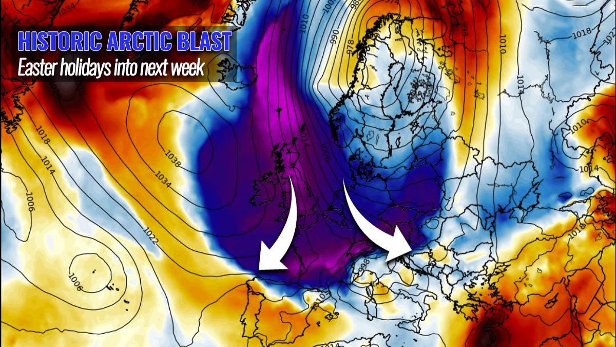
It appears likely that the Arctic cold blast will be so intense, that it will become historic in some parts of Europe. As we are now entering the second week of April after Sunday this weekend, Easter Sunday. Typically in this period, temperatures already become warmer and vegetation stages start in many parts of Europe, including the blossoming fruit trees.
Therefore, these late-season cold air mass outbreaks are nothing good but very dangerous events for this vulnerable vegetation. Very low morning and night temperatures often cause significant damage to flowering fruit trees and other vegetation. It becomes very sensitive with temperatures just a few degrees below freezing, especially in their early growing stages currently. While with this Arctic blast, the potential is there for temperatures to push even well below -5 °C in some regions and approach the 10 below zero.
Interestingly and sadly at the same time, it seems that this year will not be an exception in regard to the potentially damaging frost. As it has happened over the last few years, most of the Aprils since 2015 have resulted in damaging, locally even destructive frost due to extreme cold mornings. Thanks to earlier warmer periods in March.
Here is the quick video gif animation overview of the upcoming historic Arctic cold blast into Europe. It starts over Greenland and Iceland on Saturday, spreading into western Europe on Monday, and reaches the Alps, the Balkan peninsula, and most of the Mediterranean on Tuesday through Wednesday. As we can see, a very dramatic temperature change/anomaly will develop.
What is also interesting this year is, that the European and North American continents are both experiencing very cold outbreaks just around the Easter holidays. The ongoing cold blast across the eastern half of the U.S. is ending this weekend, then the next to be hit will be the European continent.
Now, let’s take a look into the day-to-day details of how this historic event evolves. We will cover details on the pattern change, the progress of the unusually cold Arctic blast for April, and the side events, such as a sharp surface cold front across western Europe, followed by a snowstorm over central Europe and the Balkans. And what appears likely also a very high potential for damaging frost for many.
DEEP ARCTIC COLD BLAST DEVELOPS OVER THE WEEKEND
The general weather pattern begins its change this weekend and hints that something very significant is shaping up for the upcoming days. Currently, the North Atlantic has a large blocking High developed, gradually expanding into the Arctic Canada and Greenland.
In response to this shift in the general upper-level pattern, explosive cyclogenesis takes place over the Greenland Sea. It spreads a very significant Arctic cold air mass towards northern and northwestern Europe on Easter Sunday.

With time, the surface low grows and moves into northern Europe while the surface pressure under the upper-level ridge further west keeps rising. Some weather models are hinting at a very powerful surface High on Sunday, with even more than 1060 mbar over Greenland. This creates a textbook flow between these two large-scale features, establishing a northerly meridional flow of a very cold Arctic air mass towards Europe.
The isobars (lines connecting the same pressure) are very close together over the Greenland Sea and Iceland on Easter Sunday, which means that very strong winds will help the Arctic cold air mass push towards the south. It will be an extreme temperature anomaly over Iceland, with more than 16 °C lower than normal for early April across the whole far northern North Atlantic.

A strong snowstorm will hit Norway on Sunday, with blizzard conditions in many areas along with the western parts of the country. Snow squalls will reach Scotland by the evening hours as well. The progress of the Arctic front will be quite fast towards the southeast and will Benelux and northern Germany by early Monday. With snow squalls behind the front as well.
Farther east we can also see the remnants of below-average temperatures moving from central to eastern Europe, spreading behind the front moving over the Balkans tonight.
ARCTIC COLD FRONT RACING TOWARDS THE ALPS ON MONDAY
The aforementioned general change in the weather pattern over the weekend will bring an impressive dipole pattern setup on Monday. The attached chart below indicates that the upper High over the Atlantic and Greenland will remain strong, while a very deep upper cold core will cover northern Europe to its east.
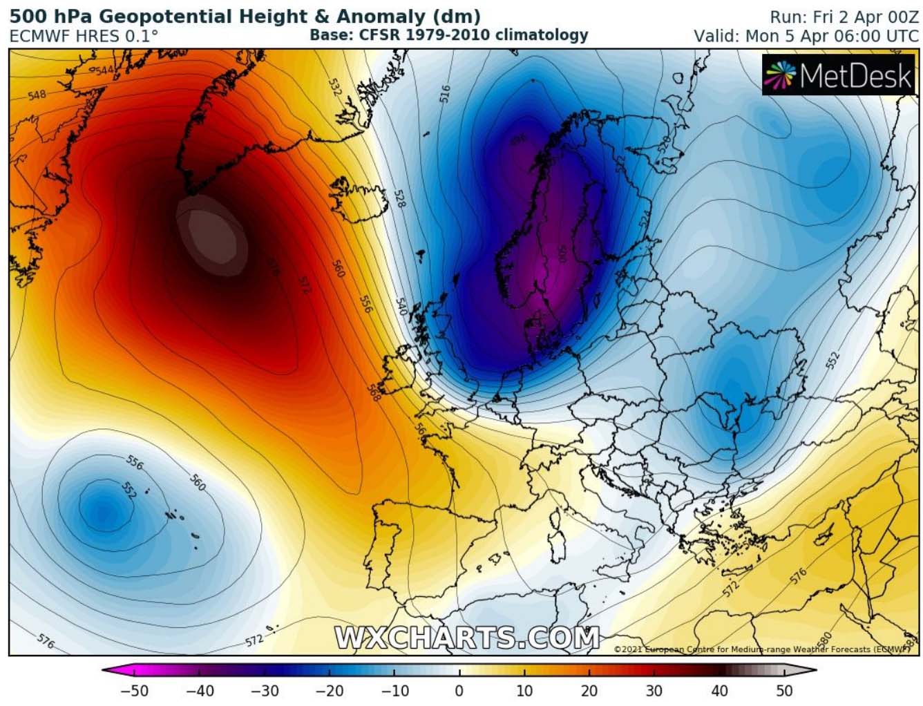
With such a position on the upper ridge, the deep trough has a clear path to continue further south across the European continent. A strong jet stream will be established in between, supporting additional cold advection towards central Europe. Basically the 500 mbar anomaly chart above hints at a very concerning, but ideal pattern position for a historic Arctic cold blast for Europe.
And yes, this means we do not want to see this in April. But unfortunately, it is very likely to occur and there is barely any chance now to change the pattern. Parts of Europe are in for a damaging cold after Monday.
Thanks to a deep surface low over northern Europe and a strong High over the North Atlantic, the significantly colder air mass than normal will blast across western Europe on Monday and quite rapidly spread also towards central Europe and the Alps.
Cold weather will first hit UK and Ireland on Monday, with more than 12 °C lower temperatures than usual for early April. After Easter Sunday temperatures in the balmy mid-10s over Ireland and England, it will be much colder the day after.
ARCTIC COLD BLAST LEADS TO A MASSIVE SNOW FOR THE ALPS ON MONDAY NIGHT, THE BALKANS ON TUESDAY
While the Arctic cold front will be extending over the central UK and the North Sea on Easter Sunday evening, it will be racing south quite rapidly on Monday and reach the Alps by the evening hours. As it usually happens with such a cold intrusion into the European continent from the northwest, a deep secondary Lee low develops over the northern Mediterranean.
This normally means an increase in precipitation for the Alps, North Italy, Slovenia, and Austria. And with the upcoming Arctic front arrival, the air mass will be cooling down very fast. So it will likely lead to a very rapid change of precipitation from rain to snow across the North Adriatic region and northern Balkans.

Some weather models are hinting at a very impressive snow event over northeast Italy, western Slovenia, and Croatia. With snow coming down to very low elevations and much closer to the coastal areas one would expect by early April. With help of a very powerful jet stream rounding the core of the trough aloft, significant lifting will support heavy precipitation with the front.
Heavy precipitation will gradually combine with strengthening winds, thanks to an increased pressure gradient between the deepening North Mediterranean low and the expanding High further north. Strong blizzard conditions are likely to develop across Slovenia and Croatia on Tuesday.
As the frontal system slows down a bit while passing across the northern Mediterranean, heavy snowfall will persist for hours. With potentially quite a lot of snow to accumulate in a matter of 6-12 hours during the frontal passage. Some areas could see even more than 30 cm of fresh snow, nearly half a meter over the higher Alps.

Heavy snow will also develop along and behind the advancing Arctic front across the Balkans through late Tuesday, with significant snow accumulations over the western portions of the peninsula. Some areas could be peaking as high as 30-40 cm of fresh snow.
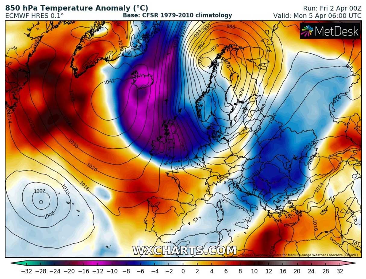
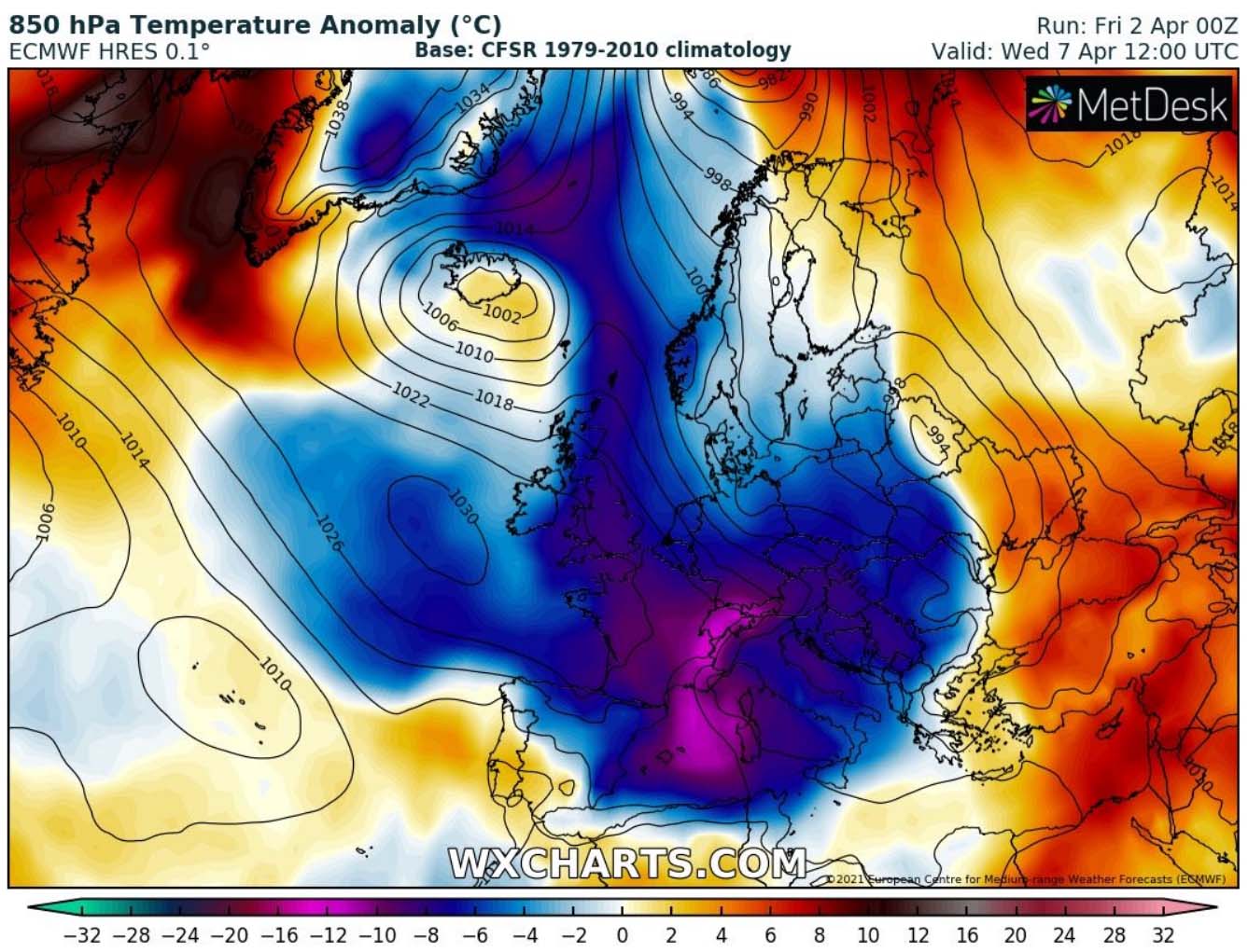
The Arctic cold blast behind the surface front will see no rest on Tuesday and will continue spreading across central Europe, the Balkans, the Mediterranean, and also northern Iberia during the day.
The air mass in the lowest levels of the atmosphere will be 10 to nearly 15 °C colder than average. As we can see from the chart above, it will be spread across a large part of central and western Europe, reaching northern Iberia as well. Thanks to the still persisting deep surface low over Scandinavia and the surface High over the Atlantic, the northerly flow will keep pushing the significantly colder air mass further south.
Let’s take a look over the ensemble forecast by the GFS model for four cities where this historic Arctic cold blast is very well seen on the charts. The upper left is Reykjavik (Iceland), then we have London (England) on the upper right. Followed by Paris (France) in the bottom left and Ljubljana (Slovenia) on the bottom right.
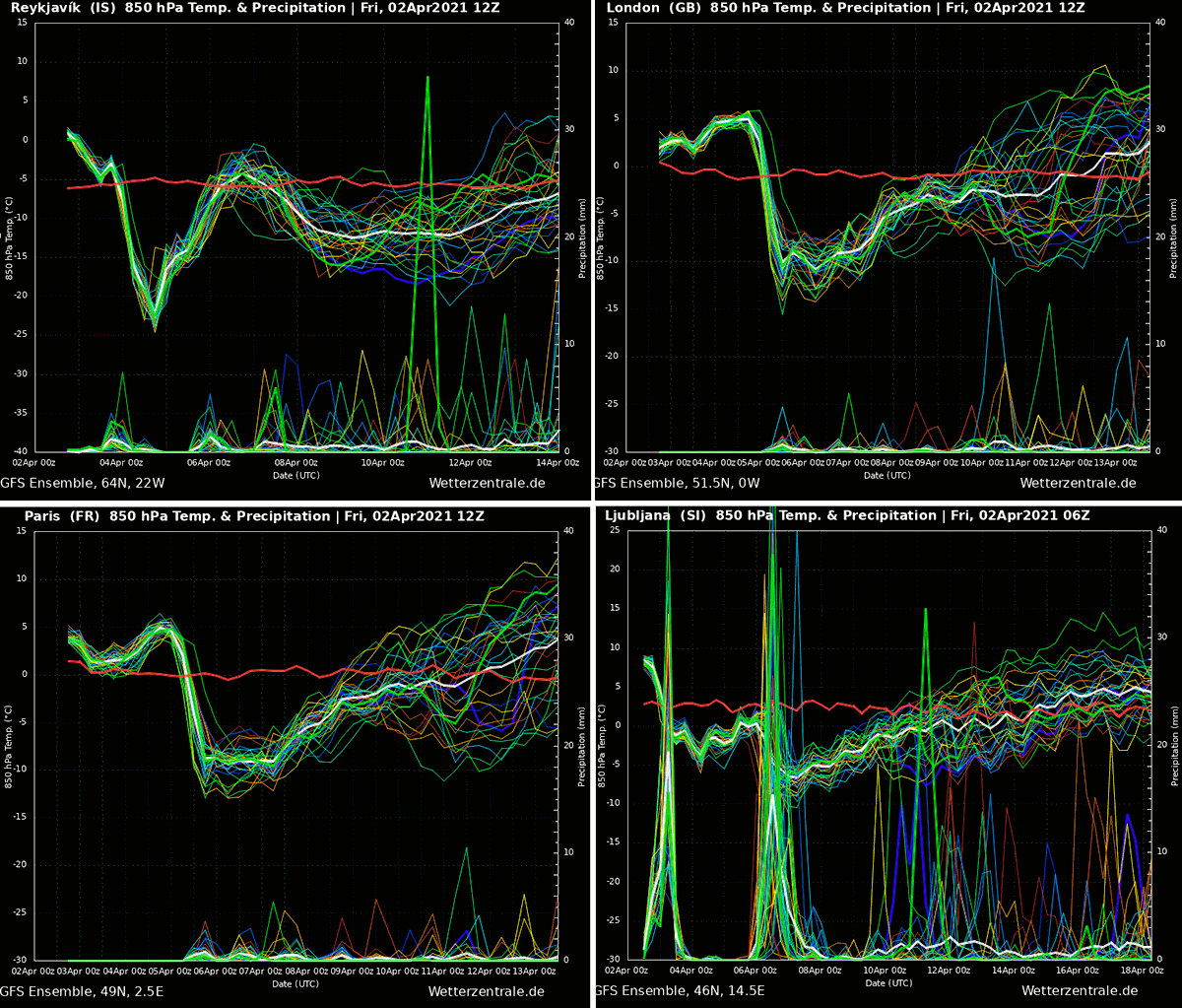
We can see a very rapid and sharp drop in temperature in Reykjavik on April 4th (Easter Sunday), as we described above. The 850 mbar (approx. 1500 meters above sea level) temperature will push to almost -25 °C, so more than 15 degrees Celsius below the average.
The charts for London and Paris are very similar, both indicating a sharp drop in temperature on Monday (April 5th) and the peak of the cold-core on April 6th, Tuesday.
While the ensemble Meteogram for Ljubljana (Slovenia – the northern Balkan peninsula) hints at two interesting spikes. The first spike is the rainfall event along the fast-moving diffuse cold front on early Saturday (Apr 3rd) this weekend, followed by the passage of the Arctic cold front on Tuesday. A lot of precipitation is forecast, with the majority of that as snow.
So heavy snowfall is likely to develop over Slovenia, and also Croatia further on Tuesday.
HIGH THREAT FOR DAMAGING FROST ACROSS EUROPE THROUGH MID-WEEK
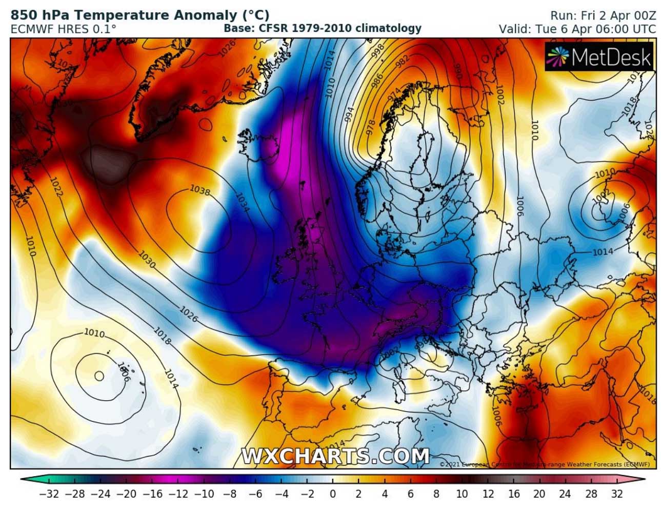
But the real and potentially damaging threat is coming after the surface Arctic cold front. What is becoming more and more likely is the intensity of the huge and deep cold pool associated with this outbreak. If we are aware that this is early April with already blossoming fruit trees and other vegetation in early growing states, the danger of damaging freeze and morning frost is a real concern.
The expansion of the cold pool is even larger on Wednesday, being the most intense and anomalous over France, the Mediterranean, and central Europe. Surely something we don’t want to see in April, not after the currently experiencing warm spring days!
Attached below is the GFS model forecast for morning temperatures across western and central Europe. Notice that most of the continent will likely see *well below* freezing temperature, even more than 6 °C below to near -8 to -10 °C around the Alps. These values are so low, that the blossoming fruits will be severely damaged, unfortunately.
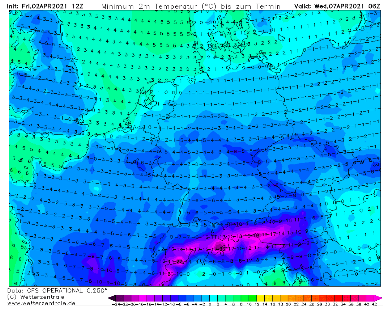
Between -3 to -5 °C will also be possible across UK and Ireland, on both Tuesday and Wednesday morning. (Well) Below -5 °C is very likely also across south-central France on Wednesday morning and across northern Spain.
Thursday will bring another morning with extremely low temperatures, those being the lowest over the Balkan peninsula. It seems likely that the general pattern evolving soon after the Arctic front will bring a relatively fast weakening of the (Bora) winds, therefore calm and clear nights are likely to develop.

If we take into account that fresh snow will also be on the ground, the result is obvious. Very low morning temperatures are quite probable. Again close to -10 °C will be possible across the northern Balkans on Thursday morning, potentially even lower further south across parts of Croatia, Bosnia, and Montenegro.
Sadly, we can be sure in case these weather charts verify, we will be dealing with a destructive frost and significant damage to fruits and agricultures. Like the ongoing worsening pandemic is not enough, the weather decides to make it even worse food-wise.
We will have more updates on this potentially historic Arctic cold blast in the coming days – stay tuned!
***Graphics by Wetterzentrale, Wxcharts, and Windy.