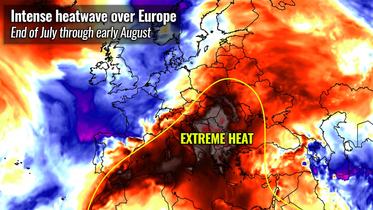
The most intense heatwave of the year is underway across southeastern Europe, with the highest temperatures between 42 to nearly 45 °C recorded from south Italy across Greece to western Turkey over the last few days. As we head into early August, the heatwave is expected to intensify even more and may challenge the European highest temperature ever recorded. Monday or Tuesday could both peak around +47 °C. Dangerous wildfire threat has developed over Turkey, parts of Greece and Sicily.
IMPORTANT UPDATE: After Monday’s high of +46.3 °C, Greece and Turkey are again challenging heat records on Tuesday and Wednesday. Extreme wildfire thre develops!
While July was very hot across the southern and southeastern parts of the European continent, the month ended with extreme heat this week and continued to increase over the weekend. The worst heat has developed across southern Italy, Greece, and Turkey, as well are surrounding countries Albania, North Macedonia, Kosovo, southern Serbia, and Bulgaria.
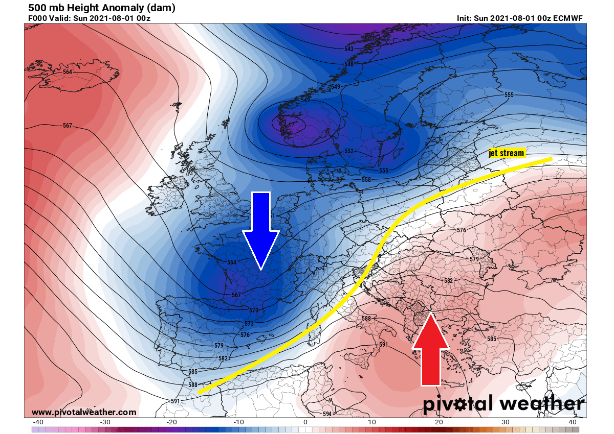
A STRONG UPPER HIGH (HEAT DOME) TO BLAME FOR THE EXTREME HEATWAVE OVER GREECE
Through the end of July, a textbook weather pattern has been established over Europe. A strong blocking upper ridge is resulting in extremely high temperatures across parts of the Mediterranean and the Balkan peninsula. The ridge often forms a so-called heat dome which typically brings very high, record-challenging temperatures.
A heat dome is a term that is used when an area of high-pressure parks over a large portion of the continent and stays there for days or even weeks. It works like a lid on a pot, trapping a very warm/hot air mass underneath. This feature is often blamed to be responsible for deadly heatwaves around the world.
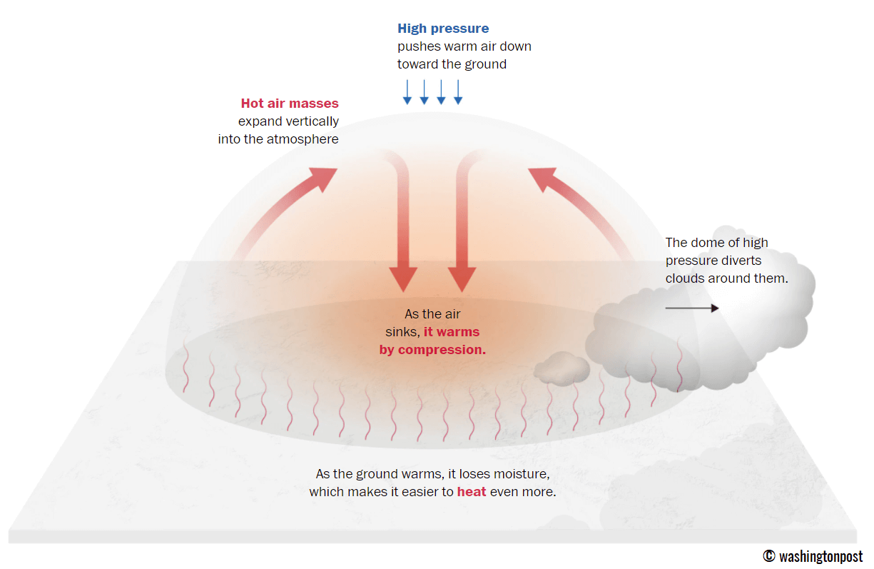
When we talk about a heat dome, it means that a trapping dome of heat lies beneath the extensive blocking (upper) High and surface high-pressure system. The heat dome results in a persistent stable air mass that begins to accumulate inside the lid and develops the heatwave, often a very intense and long-lasting one.
The temperatures observed during a heatwave are typically well above normal and often break the existing records, as it happened several times this year already.
A textbook example of the heat dome is the record-breaking heatwave which baked the Pacific Northwest of Canada and the United States at the end of June and also across most of the Lower 48 recently. The large lid helps to sustain the heatwave at the surface for a long time.
The ongoing weather pattern across the southeastern part of Europe is forecast to continue through early August, and extend the most intense heatwave of 2021 even further.
As typically difficult as the weather forecasting is, this heatwave was actually very well forecasted by the weather models since around July 20th. The weather model agreement was, unfortunately, very good and the heat is extremely intense that hasn’t been experienced in years over this part of Europe.
Temperatures were gradually increasing after Tuesday as an intense heatwave began under the strengthening upper High over the Mediterranean and the Balkan peninsula. So far, the observed maximum temperatures were up to nearly 45 °C, being the hottest this weekend.
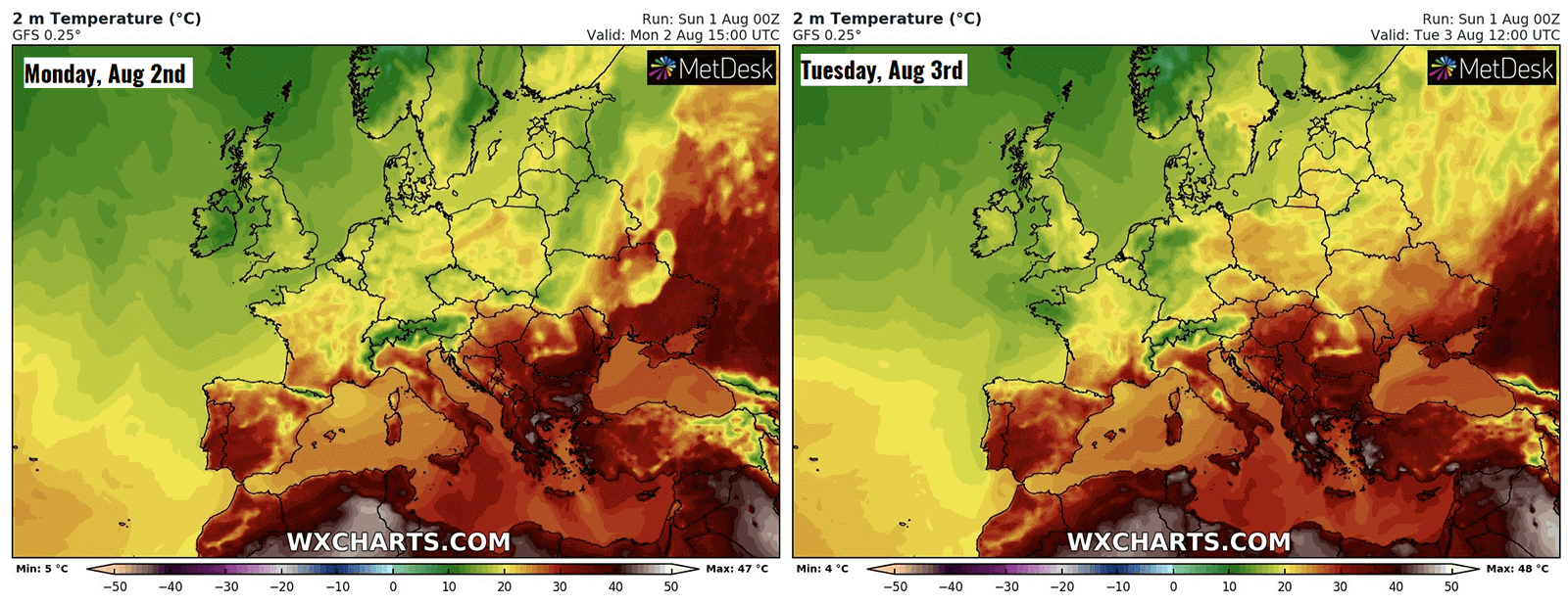
As we are heading into the first week of August, the heatwave is, believe it or not, forecast to increase further. Seriously. The forecasted maximum temperatures across parts of the southern Balkan peninsula are expected to climb very close to the all-time European heat record from Monday to Thursday.
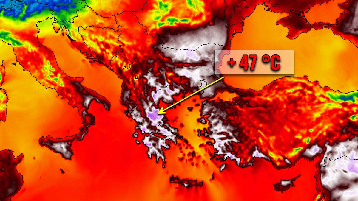
Greece, parts of Bulgaria, and western Turkey will see much higher temperatures, with probably the worst over Greece. The general weather model agreement hints at the potential for the highest temperatures up to around 47 °C possibly in some of the lowlands, precisely in the Thessaly region in northern Greece. This region is also known for extreme heat in the past.
Larissa, the capital city of the Thessaly region, is often the warmest area in Greece in summer and so will be during this heatwave. The city has the official highest temperature record of +45.4 °C, set in summer 2000.
Depending on the local topography effects in the Thessaly region during the next days, the record temperature could well be challenged in some parts of Europe.
Attached above are the latest weather model trends regarding the potentially very high temperatures across the southern Balkan peninsula. An obvious significant temperature anomaly is seen over Greece. The heatwave is very likely to continue through most of the first week of August, or even further.
The ongoing dangerous wildfire threats across Greece, Turkey and Sicily, Italy will also increase are very dry and windy conditions are expected to continue through the first week of the final month of summer 2021.
HEATWAVE INTENSIFIES FURTHER ACROSS SOUTHERN BALKAN PENINSULA THROUGH THE FIRST WEEK OF AUGUST
The scorching heat has significantly intensified over Greece on Saturday when temperatures were pushed to almost 45 °C during the peak afternoon heating hours. Not a single cloud was there to limit the extreme heating from the Sun, while the lowest parts of the atmosphere are not almost to near 30 °C at the 850 mbar level (approximately 1500 m above sea level).
The highest temperature on Saturday was reported in the town of Arfara Messinia, Greece. It was +44.6 °C (112.3 °F). Several other stations also pushed above +42 °C as well.
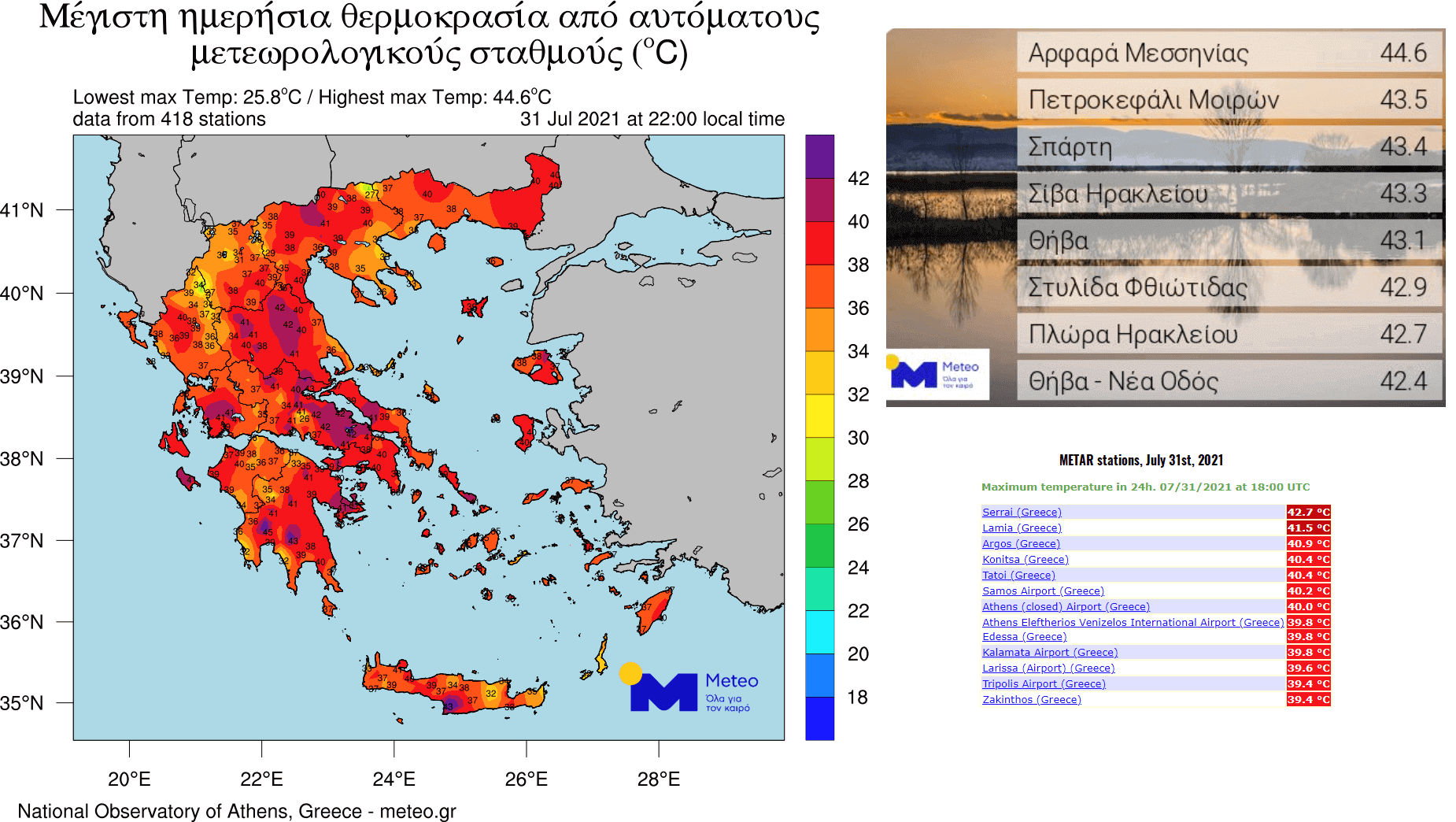
+43.5 °C (110.3 °F) was recorded in Petrokefali Moiron, +43.4 °C (110.1 °F) in Sparti, +43.3 °C (109.9 °F) in Siva Heraklion, and +43.1 °C (109.6 °F) in Thiva, Greece. The reported data and charts above include METAR stations and the automated weather stations provided by Meteo.gr.
There has also been an outstanding 24-hours minimum temperature in Greece on Saturday, July 31st. Kalymnos Island has recorded a remarkable +34.3 °C (93.7 °F), the highest minimum temperature ever recorded in Europe during the month of July.
This is also the 2nd highest overall minimum temperature after the +36.0 °C (96.8 °F) recorded in Palermo, Sicily, Italy in June 2007. More records could be broken during the peak of the heatwave these days, especially the lowest temperatures in many places.
And this general weather pattern over Europe is more or less maintained over the southeast parts of the continent, despite some significant changes further north. A deep progressive upper trough has pushes into central Europe, resulting in a severe weather outbreak over the weekend. Temperatures are much cooler further to the west of the trough.
A typical combination of the deep trough to the north against the blocking High to its east results in a strong warm advection from North Africa into the Mediterranean and the Balkan peninsula. This is when the most intense heatwaves develop in this part of Europe.
The trapped air mass under the strong upper ridge has been gradually but steadily intensifying this week. And the peak of the heatwave has not been even reached yet. So the temperatures will very likely climb even higher through the first week of August.
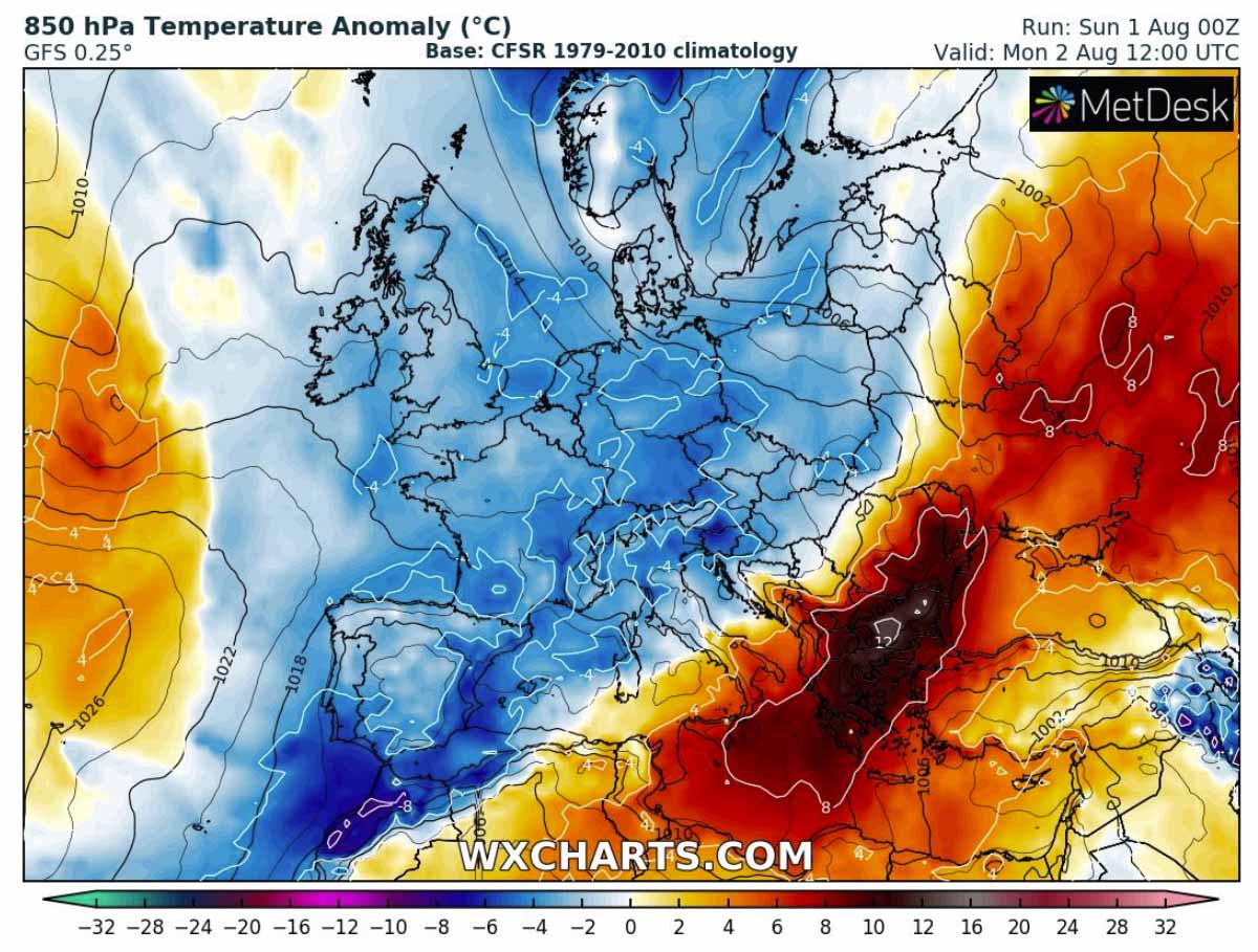
Ahead of the progressive pattern with deep troughs over a large part of western and central Europe, a very hot air mass keeps advecting towards the southern Balkan peninsula. The attached 850 mbar anomaly chart below hints at the impressive temperature anomaly of 10-12 °C above normal for early August. Right over Greece!
So the following days are expected to be the hottest of the year for the whole of Europe, as the temperature forecast is hinting at the potential for nearly challenging the all-time European high-temperature record.
The rest of Europe will see some refreshing air with the weather pattern change. And at least the first week of August will see temperatures rather below normal for many Europeans. Except those under the scorching heatwave in the southern Balkans and Turkey.
PEAK OF THE HEATWAVE COULD PUSH GREECE AND W TURKEY TEMPERATURES TO AROUND 47 °C FROM MONDAY THROUGH THURSDAY
The southern Balkan peninsula and especially Greece has not even seen the worst of the heatwave yet. Although temperatures were extremely high this weekend, as nearly +45 °C was recorded, the peak of the ongoing extremely intense heatwave is yet to come on Monday through Thursday.
Countries across the Balkan peninsula that include Greece, Albania, North Macedonia, Romania, and Bulgaria will experience around 15 °C warmer temperatures than normal. This is an extremely hot period for early August. Very hot days are also forecast across southern Italy and especially western Turkey these days.
Depending on the weather model, the general position of the upper High (ridge) across southeastern Europe varies, so the peak of the heatwave will likely be reached on Monday or Tuesday. Although the extreme heat will extend for a few more days.
The highest afternoon temperatures are forecast to push into the nearly historic values in parts of Greece on Monday. As we can see from the chart above, the peak values could reach as high as 46 to 47 °C in the central and northern parts of Greece.
Remember, this is just a degree Celsius shy of the all-time highest temperature ever recorded in Europe as we discussed earlier.
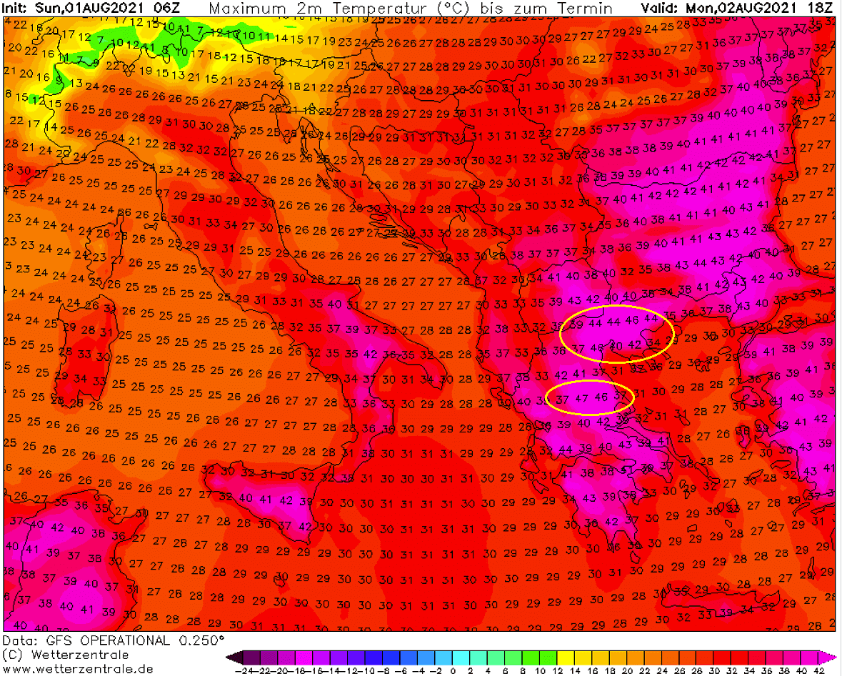
It will be extremely hot also in North Macedonia, Bulgaria and western Turkey, 41-43 °C are again possible there on Monday. As well as over parts of southern Italy, including Sicily. Up to around 41-42 °C are also likely across the lowlands of southern Romania on Monday.
Tuesday and Wednesday are likely to be the final days of the most extreme temperatures, nevertheless. Then temperatures should finally drop a few degrees, although remaining in the lowest 40s possibly throughout the rest of the week.
The attached two charts below reveal the modeled peak temperature on Tuesday (left chart) and Wednesday (right chart). Both Tuesday and Wednesday could see the highest temperature of around 46 ° in Greece, while the rest of the southern Balkan peninsula will see a tad lower values.
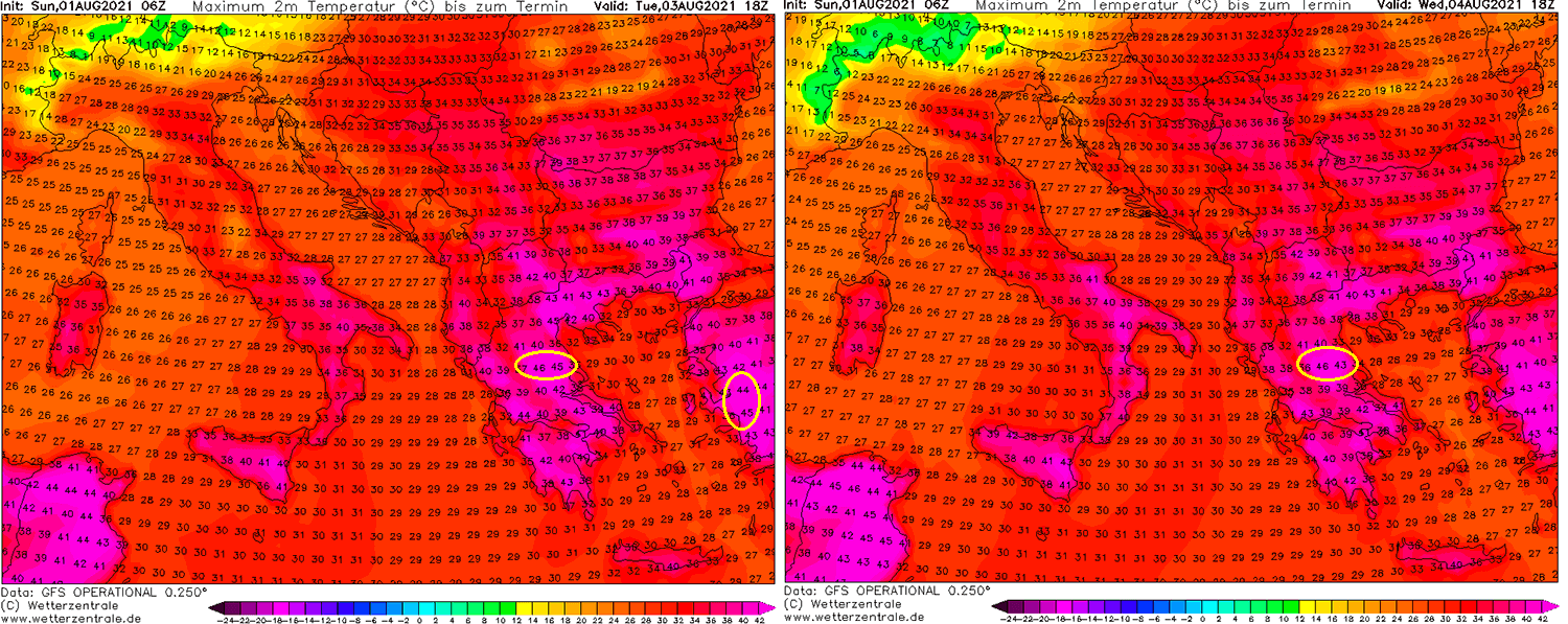
Wednesday could be the hottest day in western Turkey during this heatwave, as weather models hint at the remarkable 30 °C at the 850 mbar level (1500 m ASL). If it verifies, this could bring temperatures between 45 and 47 °C also for these parts of Turkey. Similar conditions could repeat on Thursday.
As we can also notice from the chart above, temperatures will be at least a bit lower across the rest of the Balkan through the mid-this week. Baking temperatures in the lower 40s will, however, keep occurring over Sicily, North Macedonia, and part of southern Bulgaria.
According to the mid-range weather trends, the heatwave will continue into mid-August over the southeastern parts of Europe. With basically no chance of any precipitation for Greece or Turkey in the coming weeks. This is very concerning as extreme drought will worsen.
Below’s chart is showing the temperature trends for the upcoming 14 days in Athens (Greece) and Bodrum (W Turkey).
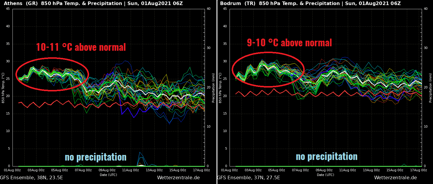
Temperatures of around 10-11 °C above normal for early August will remain in Greece until about late this week, then a bit lower afterward. Similar, 9-10 °C temperature anomaly, remain over western Turkey until the next weekend, then a tad lower, but still very high.
Both charts also hint that no precipitation is forecast at least to around August 15-20th, possibly even for longer.
The extreme heatwave has already ignited numerous wildfires in parts of the Balkans and Turkey recently, as the environment is prone to explosive fire evolution with quite some winds and very dry air mass in place.
DESTRUCTIVE WILDFIRES IN SOUTHWESTERN TURKEY
Massive and destructive wildfires are ongoing across parts of southern and southwestern Turkey. The worst are the ones to the east of Antalya, raging in the mountainous terrain inland to the north of the coast between Alanya and Antalya.
The other wildfire with a huge smoke cloud is ongoing east of Bodrum and southwest of Marmaris, Turkey. The smoke cloud is pushed far south into the Eastern Mediterranean, including the Greek island Rhodes.
Numerous firefighters with the help of helicopters and airplanes are battling these wildfires still raging in the resort towns of Manavgat and Marmaris. Tourists have also been evacuated from Bodrum on the Aegean coast.
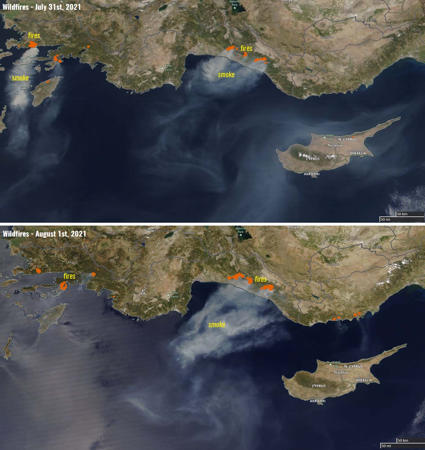
Most of the wildfires that erupted in Turkey are a result of the extremely dry heatwave that has intensified this week.
This Sunday, a massive wildfire has also started in Rhodes. The west-central parts of Rhodes Island are suffering an extreme drought this summer. The fire has ignited in the well-known place the Valley of Butterflies, near the town of Tholos.
Another dangerous and destructive wildfire is also ongoing around the city of Catania in Sicily, Italy. Numerous homes were damaged or burned this weekend, with several hundred people evacuated.
The ongoing extreme heatwave will likely worsen the ongoing fire situation, despite hundreds of firefighters battling them day and night now. Very dry land with almost no precipitation through the recent weeks sadly doesn’t see any relief soon either.
WHAT ARE THE HOTTEST PLACES IN EUROPE?
Strong and occasionally intense heatwaves are not uncommon in Europe, if we just remember the historic heat in western Europe in 2019 or similar in the past. The ongoing heatwave in the southern Balkan peninsula, especially in Greece, is the worst in recent years.
The last time it was this hot in Greece was mid-July 2017 when Heraklion, the gateway to Crete, temperatures soared to a scorching +45.9 °C (114 °F). This was the highest temperature recorded in Greece since 2004.
The all-time highest temperature in Greece is +48.0 °C (118.4 °F), recorded in two cities, Athens and Elefsina, more than 40 years ago, on July 10th, 1977. And Greece is also holding the torch for the highest recorded temperature in Europe.
Portugal holds the 2nd highest record with +47.4 °C (117.3 °F) from Amareleja, Beja on August 1st, 2003 while Montoro, Cordoba (Spain) is just a shy behind, holding the 3rd place with +47.3 °C (117.1 °F) recorded on July 13th, 2017.
Foggia, Apulia is the Italian record temperature holder, +47.0 °C (116.6 °F) was set on July 25th, 2007. The cities Mostar, Bosnia, and Herzegovina, and Nicosia, Cyprus share the 5th place with +46.2 °C (115.2 °F), recorded on the 31st of July, 1901, and September 4th, 2020, respectively.
The other countries over the southern Balkan peninsula have the following records. The North Macedonian city Demir Kapija has the record temperature of +45.7 °C (114.3 °F) on July 24th, 2007, while Sadovo, Plovdiv Province in Bulgaria has the peak of +45.2 °C (113.4 °F) from the same day.
***The images used in this article were provided by Wetterzentrale, Pivotalweather, and Wxcharts.