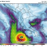
Possible development of dangerous tropical like (TLC) cyclone in Ionian sea this week
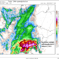
A potentially dangerous feature is seen on the maps this coming Thursday and Friday across Ionian sea towards S Greece – a warm core system …
A potentially dangerous feature is seen on the maps this coming Thursday and Friday across Ionian sea towards S Greece – a warm core system …
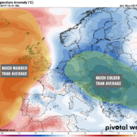
A developing pattern across Europe suggests there will be a significant cold blast (locally 5-8°C colder than average days) from north towards central Europe and …
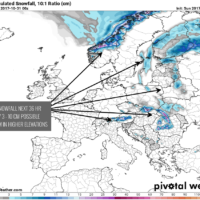
Impressive amounts of fresh snow are expected across the higher terrain of SW Norway through the next 4 days, until Tuesday Nov 14th. The current …
A progressive pattern developing from western into central Europe this weekend will bring a deep trough towards the northern Mediterranean where a transition of a …
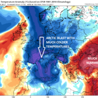
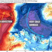
With a developed strong pattern dividing Europe in two halfs, a very cold airmass behind a deep upper low moving across ESE Europe will spread …
An interesting pattern is developing across Europe with a strenghtening upper ridge across N Atlantic and western Europe while a very deep upper level low …
Latest GFS model guidance showing some fresh snow is likely to accumate across parts of eastern Europe in response to a very cold airmass advection …
A powerful outbreak of cold airmass is spreading across east-central Europe today, associated with the very deep cyclone moving from Baltic States towards the Black …