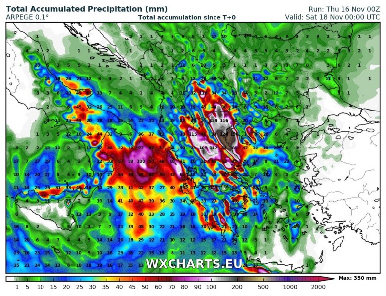
Parts of Greece, particularly central Greece, over the next 48 hours. High-resolution models suggest totals in 200-400 mm range, locally possibly more. This is a potentially very dangerous situation for more intense flooding.
Intense rainfall is expected particularly in western Thessaly and central parts of Northern Greece, where models agree on very large cumulatives, 200-400+ mm within the next 48 hours along a nearly stationary warm front. Other parts, particularly the western coast of Greece along the Ionian sea and parts of Peloponnese peninsula may also receive locally very intense rainfall with up to 100 mm accumulations; rainfall in this region will depend on the evolution of the low, possibly a Medicane, in the Ionian sea over the next 48 hours.
The active pattern with intense rainfall, which already produced devastating flooding in Western Attica yesterday is the result of the persistent cutoff upper low over the central Mediterranean. Strong Scirocco winds in the warm sector of the system over Greece, the Aegean region and eastern Mediterranean advect warm and moist airmass northward. Strong convective rainfall along persistent, backbuilding convective lines will combine with orographic rainfall along the higher terrain, for locally very intense and persistent torrential rainfall.
Stay tuned for further updates on this potentially very dangerous situation!

