Every winter, we often hear the term “polar vortex” in various media. Some call it a stratospheric hurricane, some call every winter storm a polar vortex and some even say it is a huge storm high above in the atmosphere. We are going to take a look at the actual polar vortex, what it really is and why are we so fascinated by it.
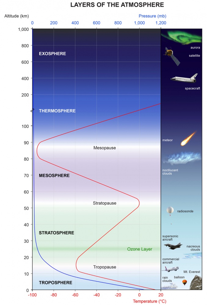
The atmosphere above us has many different layers. All of the clouds and the weather that we feel, happens in the lowest part of the atmosphere, called the troposphere. It reaches up to 8 km altitude over the poles and up to 14-16 km altitude over the equator. Above it, there is a much deeper layer called the stratosphere. This layer is around 30 km deep and is very dry.
The pressure on top of the stratosphere is 1000-times lower than on the ground. Unlike in the troposphere, the temperature in the stratosphere increases with height. At around 50 km where the temperature starts falling again with height, the stratosphere ends and the mesosphere slowly begins after the stratopause. Stratosphere is mostly known by the ozone layer it contains, which protects us from harmful effects of UV solar radiation. Over the south pole, we can find the infamous “ozone hole”, that appears every year in July and lasts till December.
A diagram of the atmosphere from www.broadwaycomputers.us
Every year as we head into autumn, the north pole starts to cool. The solar input to the north pole decreases as the angle of incoming solar rays reduces. Eventually, the angle is so low, that no direct Sun rays reach the north pole. That is known as the polar night, when the Sun stays below the horizon. The reduction in temperature also coincides with gradual pressure drop over the north pole. In the stratosphere, the process is the same.
Due to the temperature changes over the pole and the increasing temperature gradient with the warmer air further south and the effects of earth spinning, a low pressure area starts to develop across the whole depth of the stratosphere. It is like one very large cyclone, covering the whole north pole, down to the mid-latitudes.
When fully evolved, the stratospheric polar vortex can be over 10.000 km in diameter and over 30.000 km in circumference, while only 30 km deep. If you were to reduce the diameter of the polar vortex to that of a CD, the polar vortex would be just one third as thin as a CD, so it is very thing compared to how wide it is. So the polar vortex is very thin and covers a large area.
The strength of the stratospheric polar vortex gradually reduces in late winter, as the sun slowly stars to reach the north pole again and slowly increasing temperature starts to reduce the temperature difference and the pressure difference between the north pole and areas further south.
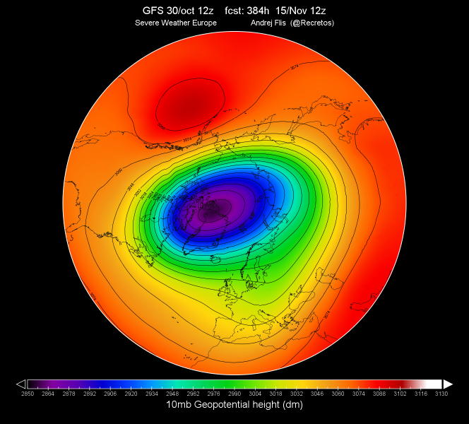
The geopotential height of the 10mb level, from GFS forecast data. lower values indicate lower pressure. Produced by Andrej Flis.
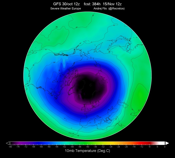
Temperature at 10mb pressure level, from GFS forecast data. Produced by Andrej Flis.
The difference between this giant cyclone in the stratosphere (from now on referred to as “polar vortex”) and the winter cyclones on the ground, is not just the size, but also that the stratospheric polar vortex has no fronts. It is in a barotropic environment. The whole process also creates another feature that is a part of the polar vortex. It is the stratospheric “polar night jet” or PNJ.
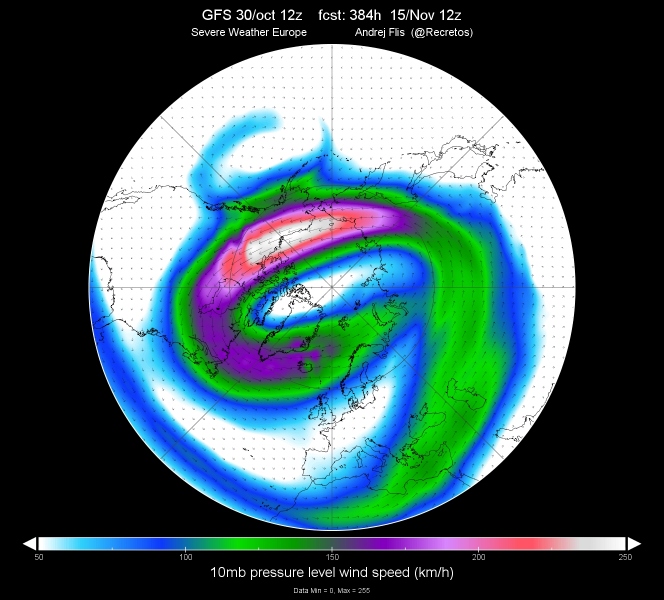
It is kinda like the jet stream that we all know, but it is quite larger and is found at higher altitudes, being most powerful in mid winter in the middle and upper stratosphere. This PNJ is most often used to determine the strength of the polar vortex. Just like winds in a winter cyclone or a hurricane, the stronger/deeper the polar vortex gets, the stronger PNJ surrounds it.
We usually look at the PNJ strength at 10 mb pressure level, which is in middle stratosphere, focusing on the 60°N latitude or 65°N latitude across the hemisphere. Both usages are okay, the difference is that 60°N is the older estimation system and 65°N is the newer one.
The stratospheric jet stream at 10mb pressure level, from GFS forecast data. produced by Andrej Flis.
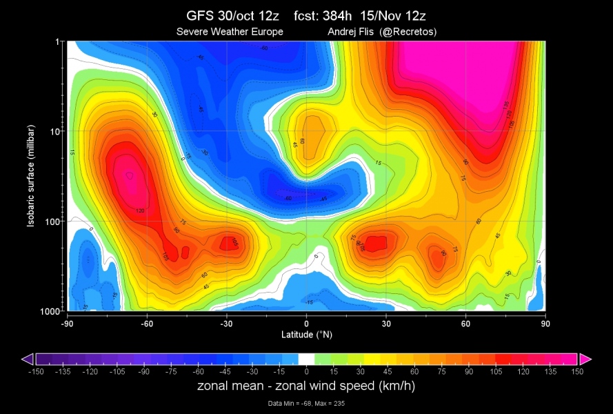
When looking at these high altitude winds, we use the “zonal mean”. In simple terms that means that we look at the average along the whole latitude line, or across the whole globe at one specific line. For example, a 60°N zonal mean, is the average along that whole latitude line from 0-360°E, across the globe. we use the “zonal wind” parameter. That is essentially a horizontal wind blowing from west to east (westerly), or blowing from east to west (easterly). On the image below we can see an example of such graphic. We can see the strong polar night jet in the stratosphere over north hemisphere (30-85°N latitude). Negative values indicate easterly winds, or zonal reversal. We can see a similar stratospheric jet over the south pole.
Zonal mean of zonal winds, from GFS forecast. produced by Andrej Flis.
Why should we care?
The polar vortex in the stratosphere can have profound effects on the troposphere and our weather. It has a lot of cyclonic energy, and when strong enough, it connects down to the troposphere, amplifying the low pressure over the pole, and higher pressure further south, which causes more zonal type of weather, with positive NAO (North Atlantic Oscillation) and AO (Arctic Oscillation).
Strong polar circulation and very low pressure over the north pole can lock the cold air in the Arctic regions up north. The weather in Europe and United States is generally mild or warm in this mode. We also monitor this by the progression of temperature and geopotential height anomalies.
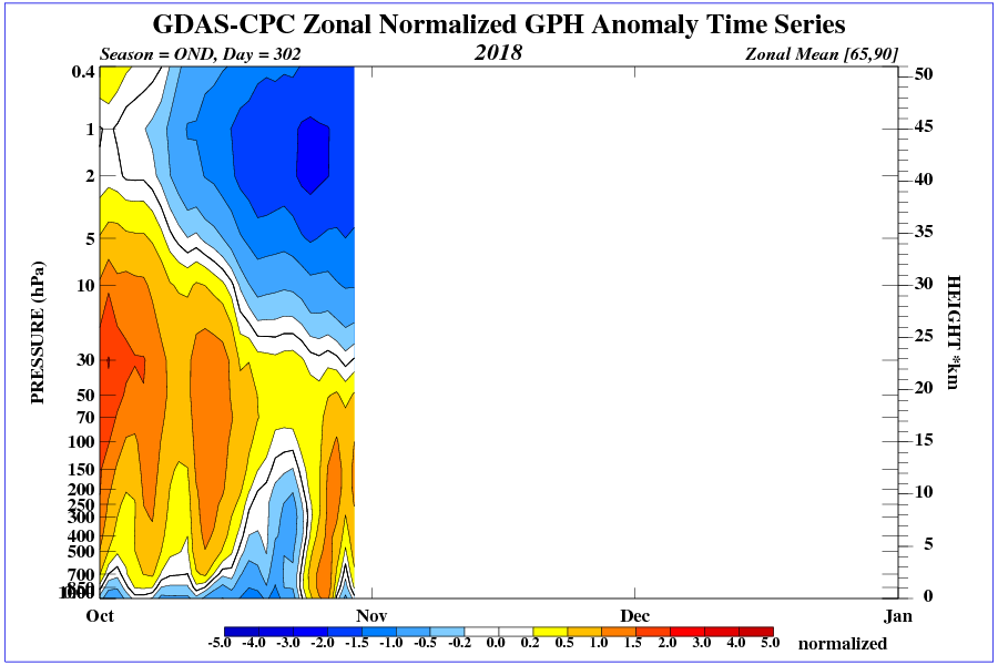
On the first image below, we have the geopotential height anomaly in the troposphere below and the stratosphere above the 100-150 mb level. Negative anomalies indicate lower pressure and positive anomaly indicates higher pressure and ridging. We can see that this year in October the lower pressure was slowly dropping down from the stratosphere, trying to make a full connection with the troposphere.
But it has not fully connected yet, since the troposphere has higher than-normal pressure as seen on the chart, which prevents the tropospheric polar vortex to fully organise for now. The tropospheric and stratospheric polar vortex are always connected, and have a varying influence on each other. It is a very complex system, where changes in one part can cause changes in the other and then back again. It is a very complex “feedback loop”.
Geopotential height anomaly by height and time over the north pole. Graphic from NOAA
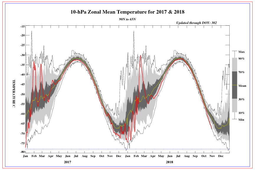
The next image below, shows the temperature in the middle stratosphere, at 10mb pressure level, over the north pole. As we can see, the temperature in October 2018, is near record-cold values, which coincides with the image above that shows the deepening end expansion of the lower pressure in the stratosphere.
Temperature progression over time above the north pole. Graphic from NOAA
The stratospheric polar vortex has its counterpart in our troposphere as well. We can usually see it on the most-often used weather map, the 500mb geopotential height. Unlike the near-circle shape that we can see in the charts of the stratospheric polar vortex above, we have a very dynamic and wavy tropospheric polar vortex.
The troposphere is where the atmosphere interacts with the ground and its complex terrain and many high mountain ranges. It causes lots of different dynamics, not to mention all the frontal development and tropical dynamics. It is one very complicated system.
On the large graphic below, you can see the polar vortex at different layers of the atmosphere. The higher we go, the more perfect shape we can see, since there is less interaction with the terrain and other complex disturbances. The waves that we see in the troposphere are called Rossby waves.
The shape of the polar vortex at different layers in the troposphere/stratosphere from GFS analysis. Produced by Andrej Flis (@Recretos)
Sometimes, all these “waves” (Rossby waves) in the troposphere can be strong enough to send disturbances and energy vertical up into the stratosphere. That can cause pressure to rise in the stratosphere and increases the temperature. If the disturbances are strong enough, a very strong and important event can occur, called the “Sudden Stratospheric Warming” or SSW for short.
It is exactly what the name suggest. It is a fast warming event in the stratosphere. What it causes is it disrupts the polar vortex and it can displace the polar vortex, or it can actually split it apart on two or more pieces. To have such even officially recognised, the stratospheric jet stream at 10mb level needs to be reversed at 60-65°N latitude, as we were reading previously above.
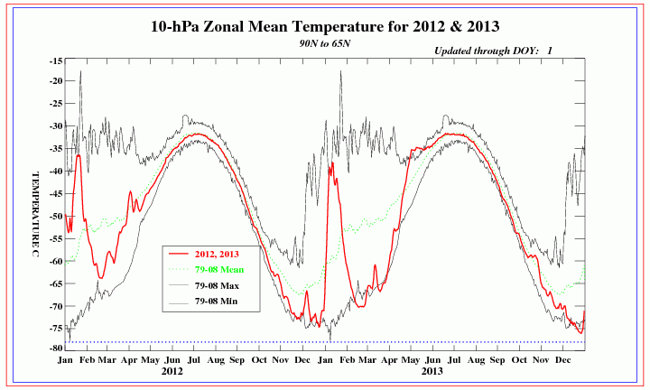
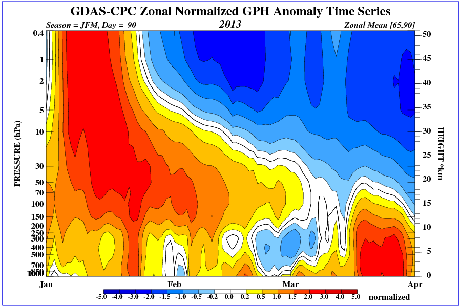
Below we have two images, the same as previously seen above, showing how an SSW event looks like. In the first one we can see the sharp temperature rise in the middle stratosphere, and on the second image we can see the geopotential height anomaly over time.
It is nicely seen how the higher pressure slowly made its way lower down into the troposphere, where it has caused higher pressure over the north pole, which has enabled cold air to move further south, bringing cold air and snow to Europe in January, February and even in March 2013. These SSW events do not happen every winter, but when they do, they can potentially have a major impact around the whole hemisphere.
Temperature progression of middle stratosphere in 2012/2013 showing the sharp temperature rise of the SSW event. Map by CPC/NOAA
Geopotential height anomaly by height, of the 2012/2013 SSW event. Map by CPC/NOAA
As we have said, the tropospheric waves influence the stratosphere, and can cause the disruption of the polar vortex. That can then have a strong effect back down on the troposphere, bringing us cold air and snow and more tropospheric waves, and the cycle repeats. Isn’t meteorology fun?
Usually we can have the SSW event impacting our weather in a few days, and sometimes in a few weeks. It all depends on the state of the troposphere and how dynamic it is. Sometimes, SSW events can bring cold weather and lots of snow to one region only, like United States or east Asia, sometimes they can affect the entire hemisphere and sometimes they have no important effect at all.
There are a lot of dynamics and complicated processes to consider. The animation below from NASA, shows the 2012/2013 SSW event (officially marked on January 6th) and polar vortex disruption in the upper stratosphere at 7mb level. Essentially it is like tearing apart a large cyclone.
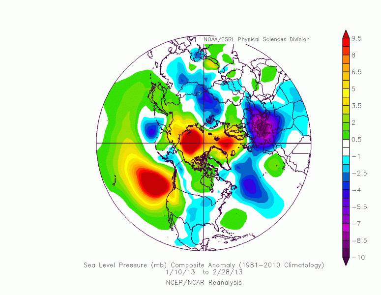
The graphic below shows the pressure anomaly after the SSW event in January 2013. We can see high pressure over the north pole, and low pressure and cold air further south over Europe, Asia, USA and Atlantic.
Pressure anomalies from January 10th to February 28th 2013. Map by CPC/NOAA
Usually an SSW event does not happen just all of a sudden, but is usually a chain of events. There can be many smaller disturbances in the stratosphere before the major event happens. Those smaller disturbances can help keep the polar vortex weaker and prevent it from fully strengthening, so it is ready to be fully disrupted later with a stronger disturbance.
We will follow the development of the stratospheric polar vortex regularly, and we will post updates on any important development and disturbances in the stratosphere, so stay tuned.
Andrej Flis,
@Recretos.
