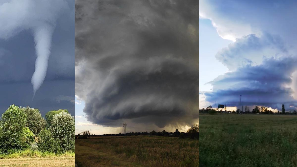
At least 7 tornadoes were reported by storm chasers and the public across the Po Valley this afternoon, Sept 19th. A tornado outbreak has developed under a well-defined upper low moving across the northern Mediterranean and the Alps, producing a number of isolated supercell thunderstorms. Significant damage has been reported.
It has been a pretty wild year with severe weather and tornadoes reported in various parts of Europe over the last few months, including the destructive tornado in Hodonin, Czech Republic on June 25th.
This Sunday, Sept 19th, several areas across the large plain of northern Italy – known as the Po Valley Plain – have been hit by damaging tornadoes, with reports of destroyed roofs, cars, and downed trees. Today’s event is one of the tornado outbreaks with the highest number of tornadoes in recent years.
Let’s see further details about the event and the general weather pattern over this part of Europe this weekend.
AN UPPER LOW MOVING ACROSS THE NORTHERN MEDITERRANEAN
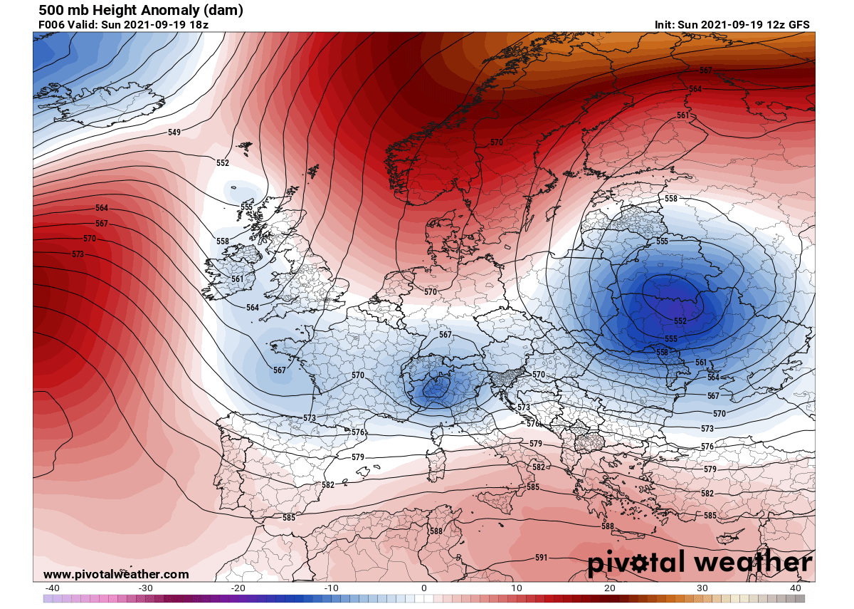
The ongoing general weather pattern over Europe reveals a deep upper low strengthening over eastern Europe, locked-in with the strong blocking High across northern Europe and the Arctic region. Together they are resulting in a significant cold outbreak into the Baltic region and eastern Europe.
Further west, another shallow but well-defined upper-level low is moving across the northern Mediterranean and the Alps. This is the featured system that has resulted in a tornado outbreak across the Po Valley in the northern Italy plains today.
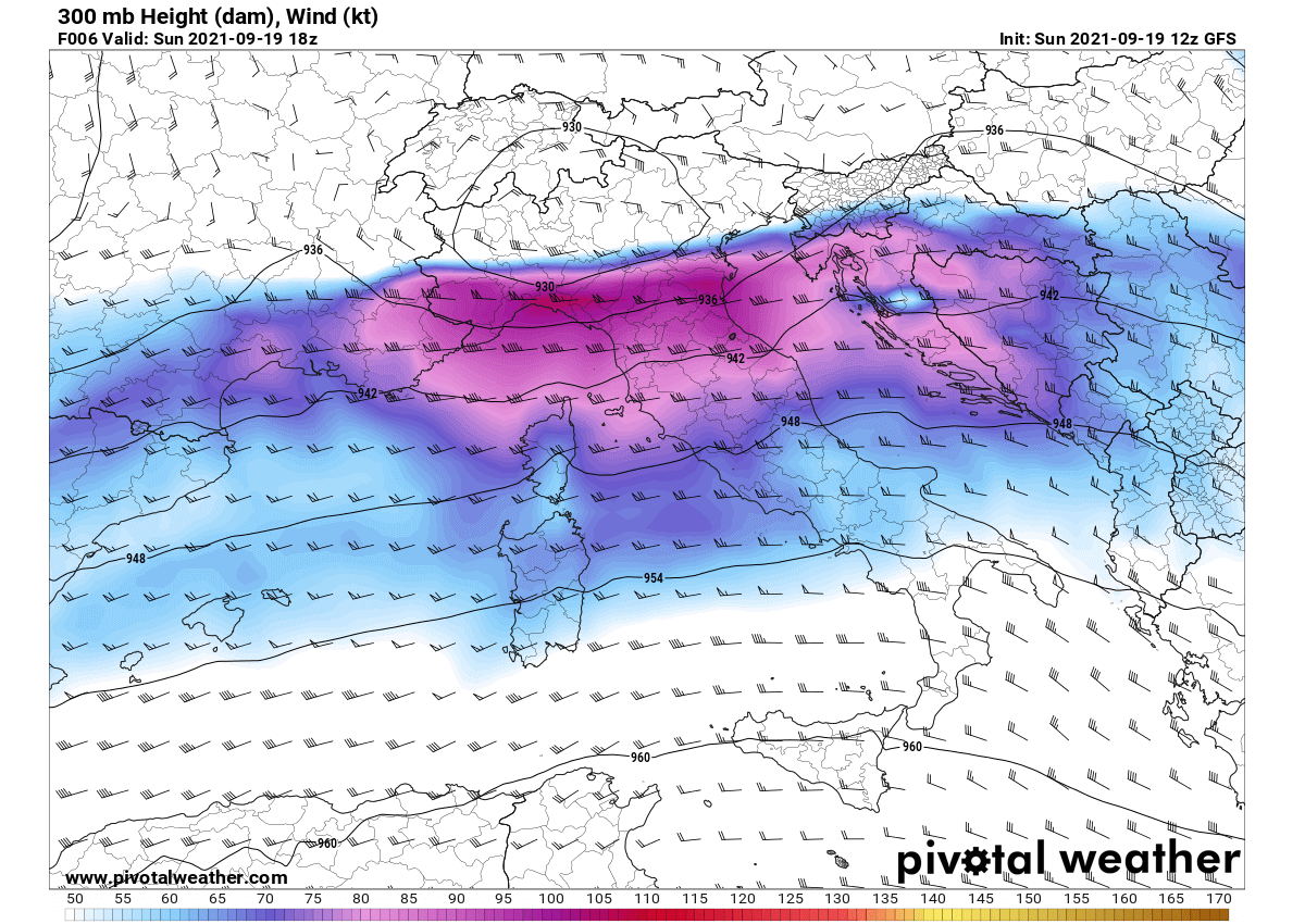
The upper low that can be seen moving across North Italy has been rounded with powerful winds aloft, a strong westerly jet stream is providing the favorable upper-level support for vigorous thunderstorm development over the region.
This jet stream also separates warm/hot air mass over the Mediterranean from the cooler weather to the north of the Alps.
This large upper-level low is also well-visible on the water vapor and visible satellite imagery – see the attached image below. The upper low is centered over northwestern Italy Sunday afternoon (marked with a white circle), while the blue arrows represent the jet stream aloft.
A pronounced dry intrusion that provides a boost to the thunderstorm activity is marked with yellow around, penetrating into the upper low from the west-southwest underneath the jet stream aloft – the left-exit jet region.
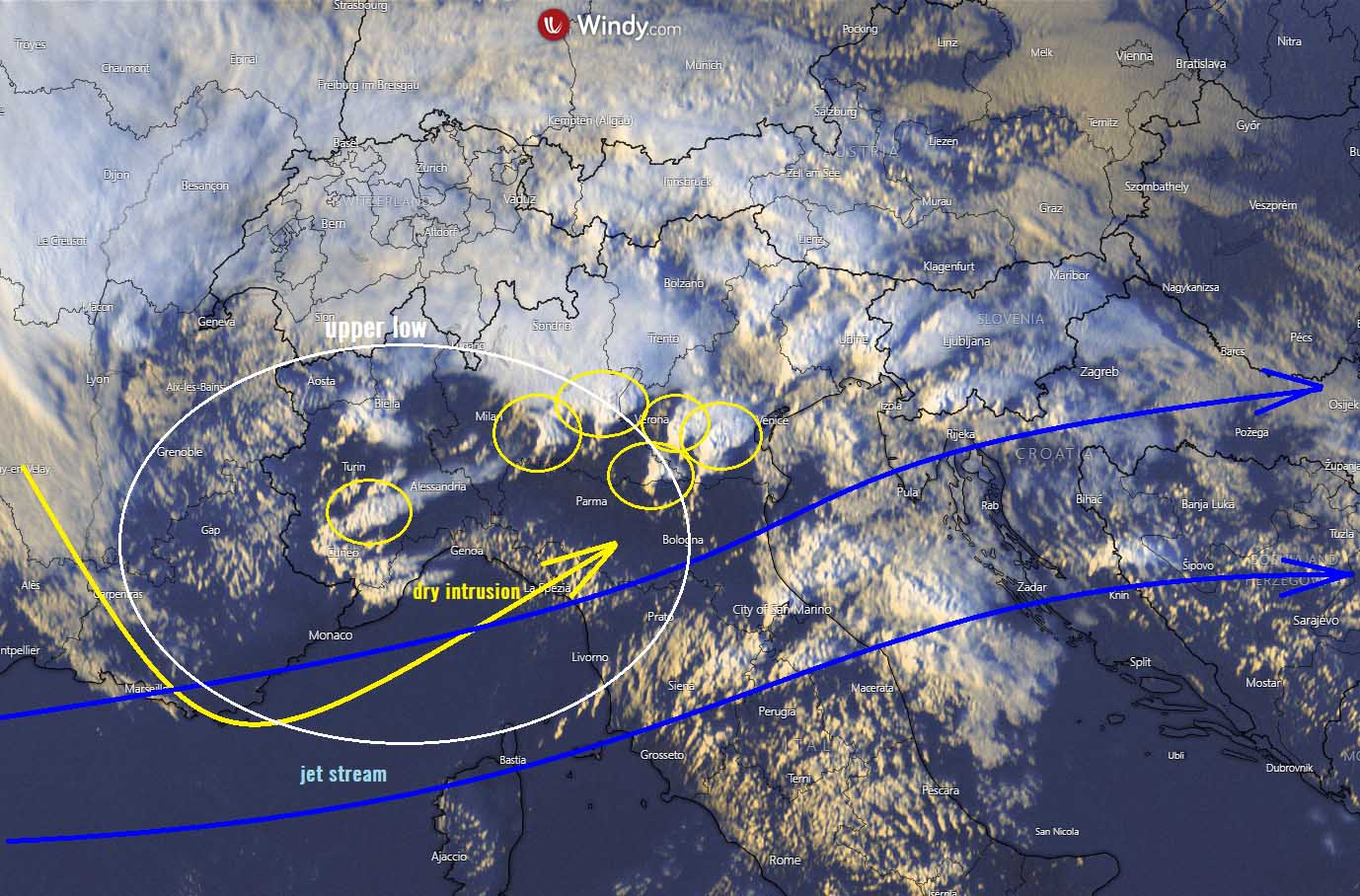
Marked with small yellow circles are those isolated supercell thunderstorms that produced tornadoes or severe thunderstorm events. These cells were generally moving east-northeast and brought quite some damaging severe weather, from both severe winds and tornadoes.
Isolated supercell thunderstorms were also perfectly visible on the radar imagery, indicating a strong core, producing large hail and severe winds. Some of these storms were also hinting at the hook-echo radar signature that is usually found with tornadic supercells.
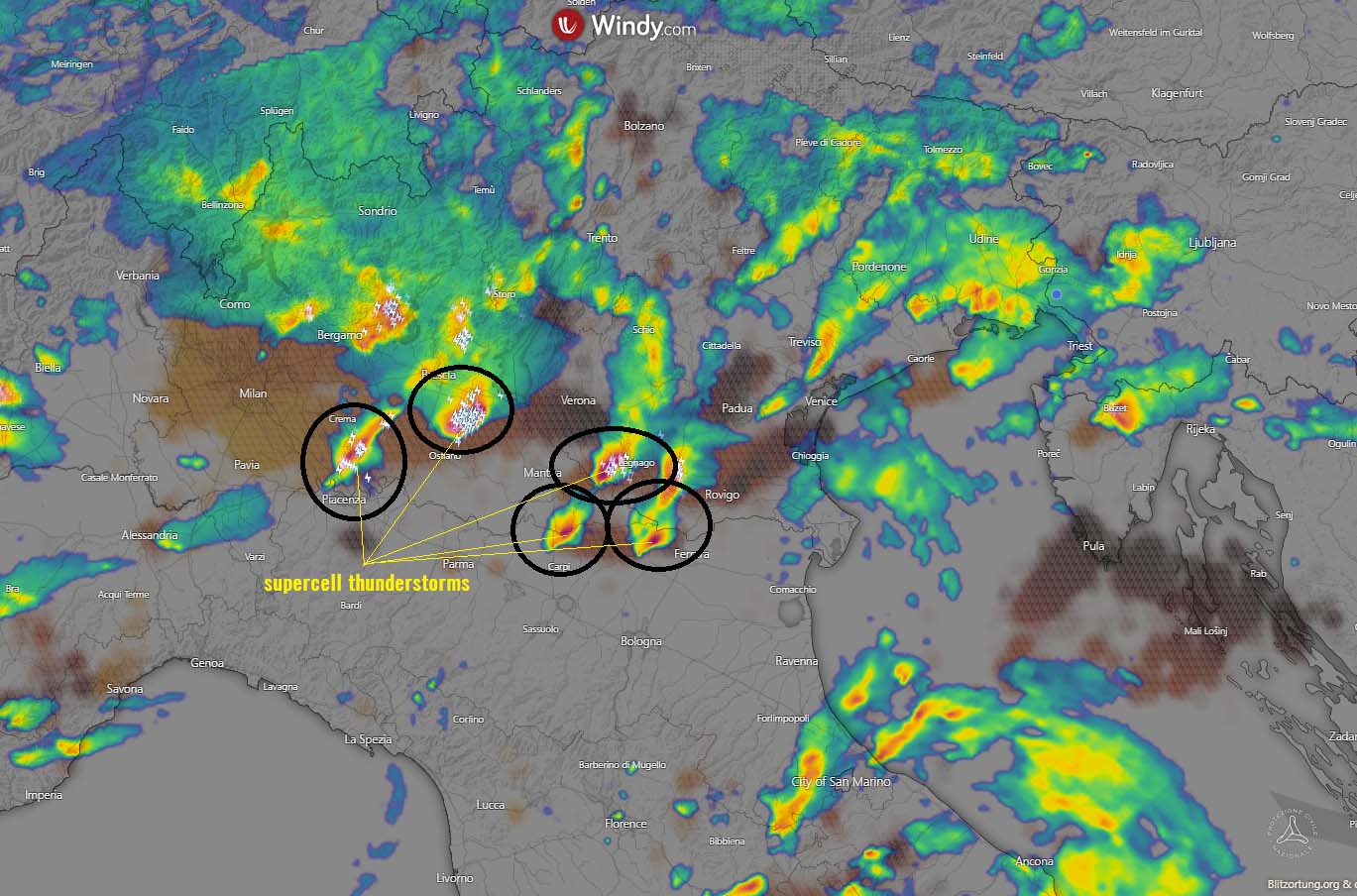
Tornadoes were reported from Settimo Milanese (MI), Roncaro (PV), Corte Palasio (LO), Soresina (CR), Manerbio (BS), Castiglione dello Stiviere (MN) and Medole/Castel Goffredo.
The chaser reports hint that some of those were landspouts while a few of those tornado reports were mesocyclonic tornadoes.
SEVERE WEATHER AND TORNADO OUTBREAK ACROSS LOMBARDY, PO VALLEY, NORTH ITALY
The environment across the Po Valley is often in the prime position for an outbreak of severe thunderstorms when a frontal system or an upper low enters the region from the northwest. The North Italian Plains are placed to the south of the Alps, which leads to a formation of a secondary Lee low behind the Alpine mountain chain.
This means that surface pressure deepens in the Plains, creating a unique environment trapped with the Alps to the North and the northern Apennines to its south. This Sunday, this classic environment occurred again with unstable air mass over the Plains, thanks to the advection of very moist air mass from the east – from the warmer Adriatic Sea.
At the same time, the mid-level winds that are normally rounding the base of the upper low, were from the southwest, across the Apennines mountain chain. This usually leads to a formation of a dryline (a drier air mass mixing down from the mountains) into the central Po Valley plains, providing the trigger of thunderstorms.
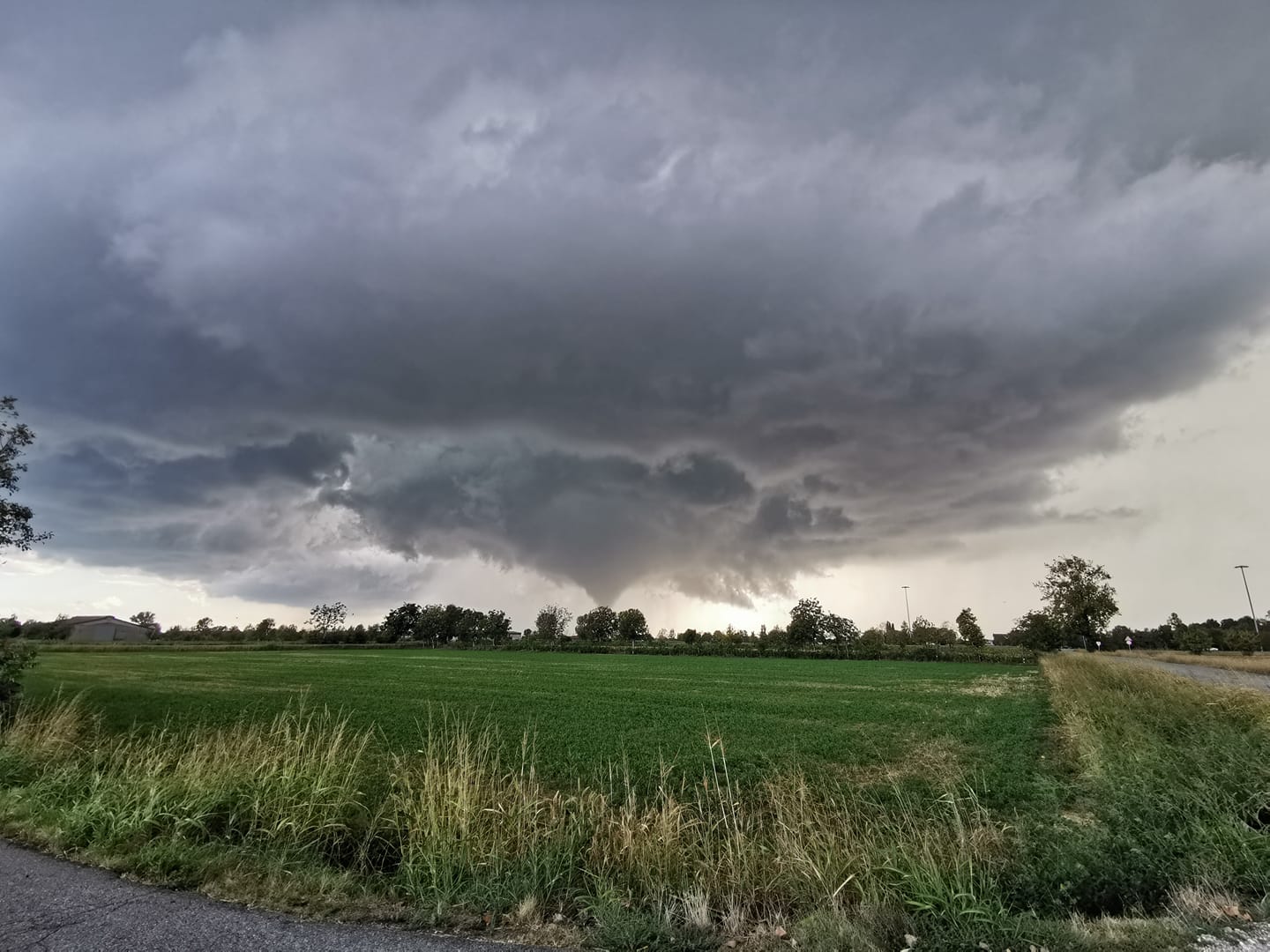
Above: Video of a supercell and tornadoes near Soresina and Carpenedolo, Italy by Luca Vezzosi
The severe weather outbreak has started in the early afternoon, as a few isolated supercell thunderstorms initiated near the dryline bulge from the Apennines, while the upper-level low was emerging into the northern Mediterranean from the west. Activity has then been spread further north-northeast until the evening hours.
Healthy moisture across the Po Valley plains has provided moderately strong instability to support the rather explosive nature of thunderstorms. The strongly unstable air mass spread across the Po Valley has then been overlapped with the powerful jet stream aloft, allowing storms to quickly become severe and supercellular.
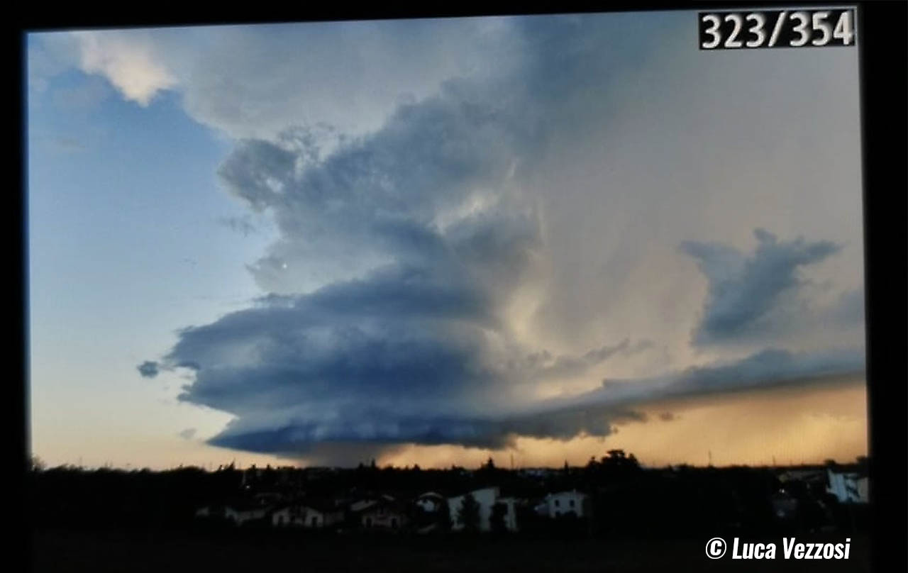
Above: Photograph of a supercell thunderstorm near Verona, Italy by Luca Vezzosi
Italian storm chasers were out chasing some of these supercells, and the photographs are truly astonishing. Revealing a majestic structure of mesocyclones that can be often found in the Tornado Alley in the United States.
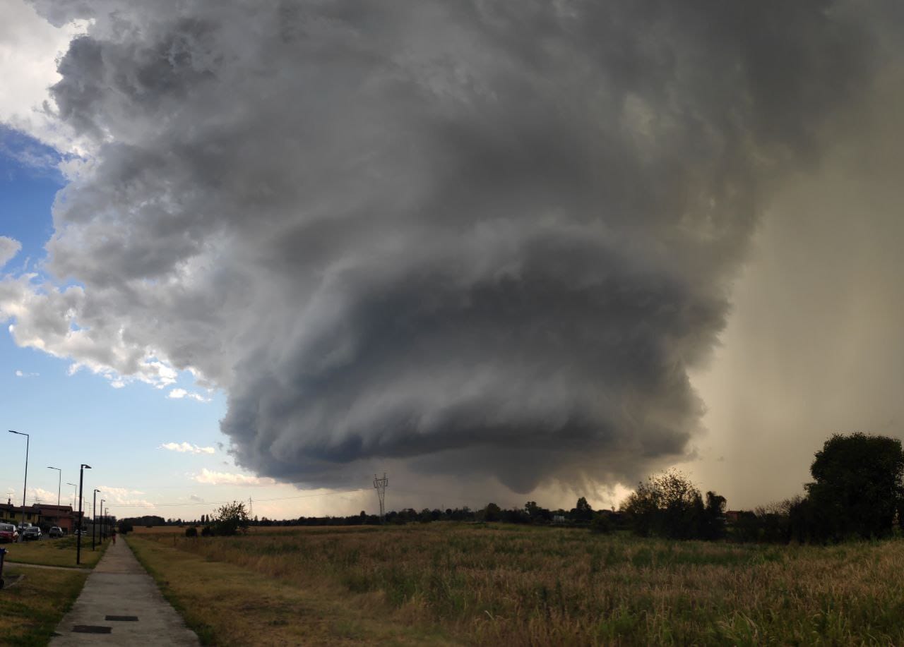
Above: Photograph of a supercell thunderstorm with a tornado near Carpendolo by Luca Vezzosi
Above: Spectacular photograph of a supercell thunderstorm with a developing tornado near Castiglione dello Stiviere (MN) by Samuele / Tornado in Italia
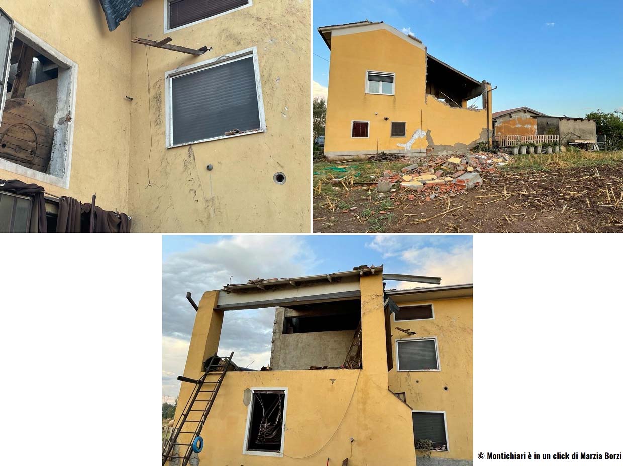
Above: Sigificant tornado damage in Carpendolo (BS), Italy by Montichiari è in un click di Marzia Borzi
Here are now a couple of video reports of supercells and tornadoes from the Po Valley:
- Supercell thunderstorm video from Po valley by Luca Vezzosi
- tornado near Medole/Castel Goffredo by Irene Comparini
- Damaging tornado in Fossoli di Carpi by Video Simonetta
- Tornado hit house near the Fossoli airport by Ilario Larosa
Statistics of tornadoes in Europe
Every year, there are about 300 and 500 tornado reports collected into the European Severe Weather Database – ESWD on average. Those reports also include waterspouts that are most often reported across the Mediterranean Sea, as well as North and Baltic Seas, and the Black Sea.
In the last decade, there is quite a good track of tornado reports, but many tornadoes still get unreported as they hit sparsely populated rural areas and no storm chasers or locals see and report them.
The Mediterranean region has the highest number of tornadoes in the autumn and winter month, while most of continental Europe sees the maximum of tornado reports during the summer months, from May through August or early September.
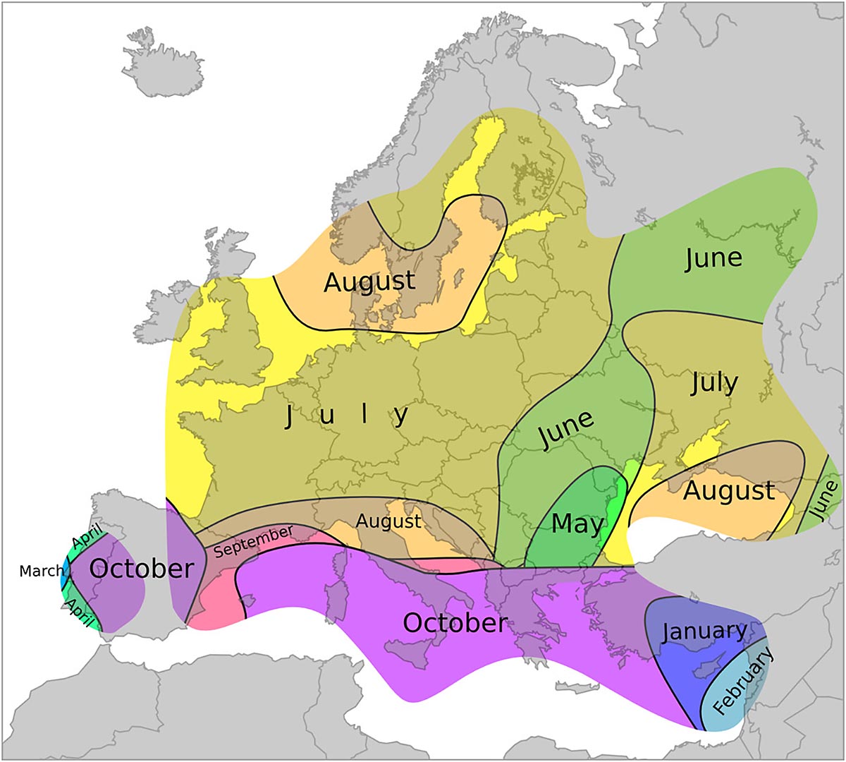
Italy and Greece see the highest tornado activity, thanks to the warm Mediterranean Sea that also extends the thunderstorm activity into the autumn months.
There is also a quite high number of fatalities caused by tornadoes in Europe, averaging between 10 and 15 on average each year. And most fatalities are often caused by the F2/F3 or stronger tornadoes.
The European Severe Storms Laboratory has investigated that: From 2010 until 2020, 3827 tornadoes have occurred over land in and around Europe. 329 of them were strong (F2 or higher), 28 intense (F3 or higher), and 2 violent (F4 or F5). The deadliest tornado since 1950 occurred in Ivanovo, Russia (9 June 1984) with 69 fatalities.
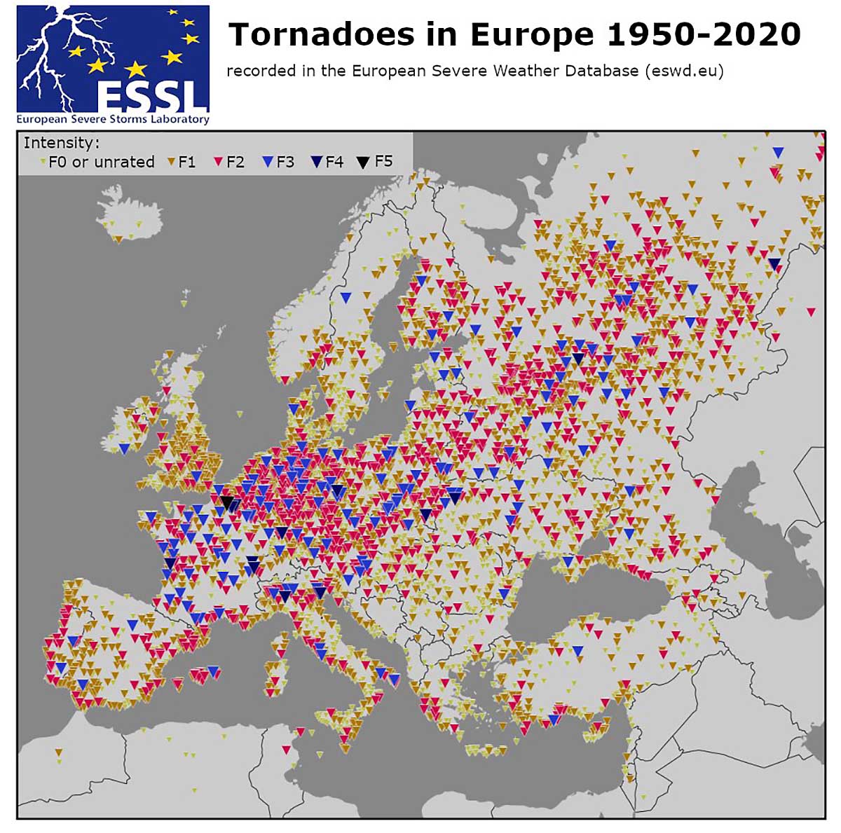
Above: Tornadoes in Europe between 1950 and 2020. Credits: ESSL
You can learn more about tornado climatology in Europe in this article: A Climatology of Tornadoes in Europe: Results from the European Severe Weather Database
Note: This is breaking news of the tornado report, so some further details or corrections will be added as they appear in the coming hours and tonight.
***Images used in this article were provided by Windy and Pivotal Weather.