Here we go again – just like last year, the Atlantic hurricane season 2021 is already setting the records for the history book. The 5th tropical storm Elsa has formed this Thursday, becoming the record-breaking earliest 5th named tropical cyclone. On Friday, Elsa has been upgraded into the 1st hurricane of the season in the eastern Caribbean. Elsa will continue towards landfall in Cuba and then possibly turn towards the US mainland landfall next week.
**** IMPORTANT UPDATE ****
********
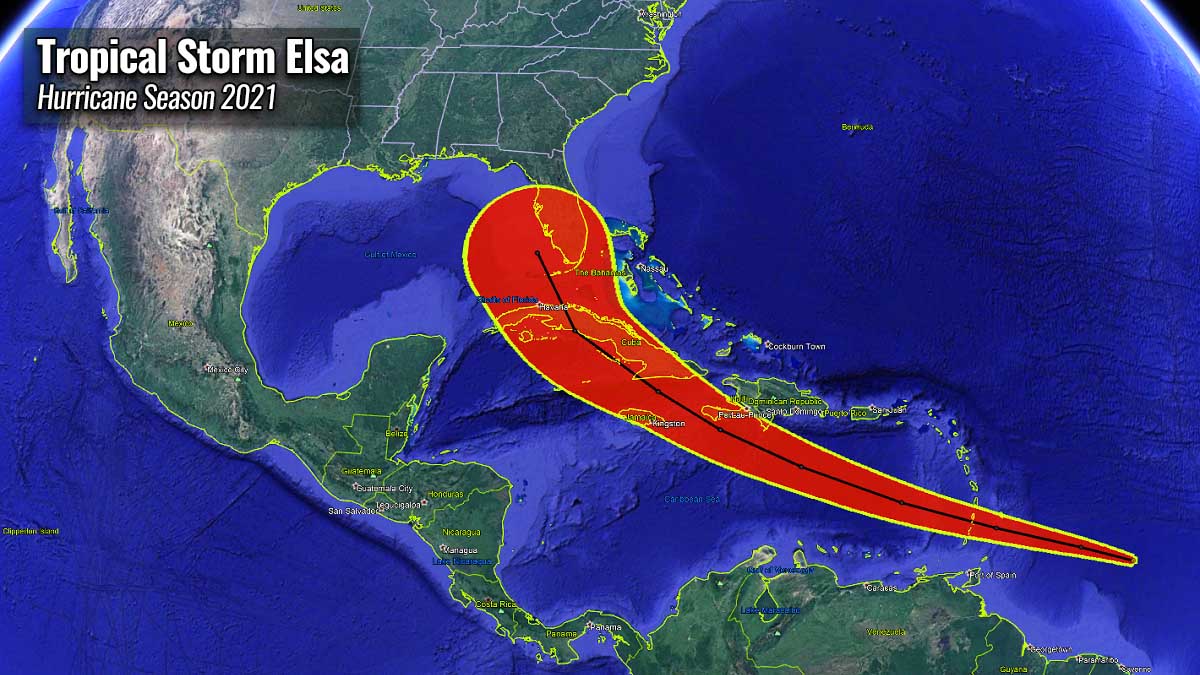
A Tropical Storm Elsa formed about 600 miles east-southeast of the Windward Islands and was upgraded into the 1st hurricane of the 2021 season on Friday. Currently packing 75 knots (85 mph) of maximum sustained winds, with the minimum central pressure of 991 mbar.
A Hurricane Warning is in effect for:
- Southern coast of Dominican Republic from Punta Palenque to the border with Haiti
- Southern portion of Haiti from Port Au Prince to the southern border with the Dominican Republic
- Jamaica
A Tropical Storm Warning is in effect for:
- St. Vincent and the Grenadines
- St. Lucia
- Martinique
- The coast of Haiti north of Port Au Prince
- South coast of the Dominican Republic east of Punta Palenque to Cabo Engano
A Hurricane Watch is in effect for:
- The Cuban provinces of Camaguey, Granma, Guantanamo, Holguin, Las Tunas, and Santiago de Cuba
A Tropical Storm Watch is in effect for:
- Grenada and its dependencies
- Saba and Sint Eustatius
- North coast of the Dominican Republic from Cabo Engano to Bahia de Manzanillo
- Cayman Brac and Little Cayman
Earlier this week, the Tropical Storm Danny formation on Monday was the 4th tropical cyclone of the Atlantic Hurricane season 2021. This means that this season is the 5th year with 3 tropical cyclone formations during the month of June. A pretty rare occurrence.
When Tropical Storm Elsa formed on Thursday, it became the earliest 5th Atlantic named storm formation on record. The previous record was set last year – A tropical storm Edouard formed on July 6th. It didn’t last long, Elsa strengthened into a hurricane while moving into the eastern Caribbean.
Note that only 3 years on record have had 4th Atlantic named tropical cyclone formation prior to July 1st; those were 2016 (Danielle formed on Jun 20th), 2020 (Dolly formed on Jun 23rd), and 2012 (Debby formed on June 23rd). And also only 4 years on record have had 3 Atlantic named storm formations in June: 1886, 1909, 1936, and 1968.
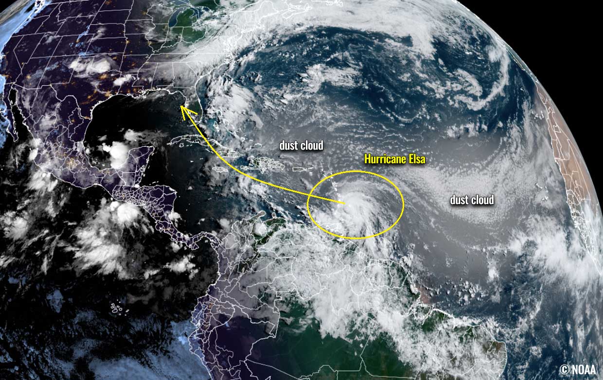 Above: Hurricane Elsa entering the eastern Caribbean, surrounded by a Saharan dust cloud. Credits: NOAA
HURRICANE SEASON 2021 – TROPICAL STORM ANA, BILL, CLAUDETTE, and DANNY
The first tropical cyclone of the hurricane season 2021 was Tropical Storm Ana. It formed on May 22nd, about 10 days before the official start. The peak intensity of Ana was 45 mph and it also generated an ACE of 1.01. Its minimum central pressure was 1006 mbar.

The second named system was a Tropical Storm Bill, which formed several hundred miles east off the coast of North Carolina and was active from June 14 to 16th. Bill never had any land areas interact as it remained over the open waters of the Northwest Atlantic, Its peak intensity was 60 mph with the minimum central pressure of 998 mbar.
The Tropical storm Claudette formed along the Mexico coast in the southwestern Gulf of Mexico on June 19th, turned northeast, and made the very first landfall of 2021 along the U.S. mainland about 36 hours later.

Claudette had a peak intensity of 45 mph and a minimum central pressure of 1004 mbar while going across the Gulf of Mexico and made landfall in southern Louisiana, After the landfall, the system was downgraded into a depression while moving across the Southeast U.S., ejecting into the Atlantic and dissipate.
This Monday’s Tropical Storm Danny was the 4th named storm and just showed that it means seriously with the term “above-normal” hurricane season 2021. Danny lasted less than 24 hours since it got upgraded and made landfall at the southwest South Carolina coast on the same day.

Tropical Storm Danny was also the 2nd tropical cyclone that made landfall on the US mainland this year, after Claudette. And the first June landfall in South Carolina after Hurricane One in 1867, so in more than 150 years.
An average Atlantic hurricane season typically produces up to 14 named tropical storms, 7 hurricanes, and about 3 major hurricanes (Category 3 or greater). The hurricane season has two peaks, one occurs during the early/mid-September and the second one normally occurs in mid-October.

The overall activity normally begins increasing more significantly in early August. It may begin earlier this year as there are some mid-range trends that would suggest increasingly improved conditions coming together after mid-July.
WARM TROPICAL ATLANTIC AND INCOMING MJO WAVE
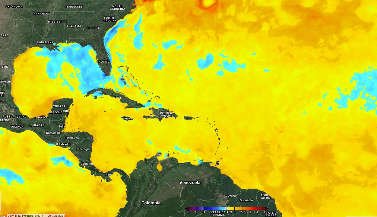
The tropical Atlantic Ocean waters are already very warm, especially across the western Atlantic, including the Caribbean Sea and the Gulf of Mexico. Sea surface temperatures are ranging from around 27-29 °C in the central Atlantic, up to around 29 to almost 30 °C in the western Caribbean.
Similar temperatures, 28-29 °C are spread across the whole Gulf of Mexico, with the highest sea temperatures observes across the western parts of the Gulf Coast.

Warm or hot sea waters are the most important source of energy to fuel convective storms. While very high sea temperatures typically lead to explosive development and therefore rapid strengthening of tropical cyclones.
When the tropical waves – this time we had Elsa – are entering into these warm sea waters, they also combine with favorable upper-level support over the tropics. Sea temperatures are quite warmer across the whole Atlantic Basin.
So besides the warm seawater temperatures, the upper-level flow support is another very important when it comes to tropical cyclone formation. It is known as the MJO wave.
WHAT IS THE MJO WAVE (MADDEN-JULIAN OSCILLATION)?
An MJO is an abbreviation for the Madden-Julian Oscillation, known as the largest and most dominant source of short-term tropical variability. It is an eastward-moving wave of thunderstorms that circles the entire planet on the equator in about 30 to 60 days.
The MJO wave has two parts, enhanced rainfall on one side (wet phase), and the suppressed rainfall on the other side (dry phase). This means that there is an enhanced thunderstorm activity with a lot of rainfall on one side and reduced thunderstorm potential and drier (more stable) weather on the other side.
The wet phase typically leads to diverging flow in the upper levels of the atmosphere, so the air parcels are rising (ascending) while the dry phase brings converging flow as air parcels are descending. This horizontal movement of the air masses within the wave is known as the Velocity Potential (VP) in the tropics.

Nowadays, we can track the MJO wave movement around the equatorial region pretty well with the weather model data. We are able to look at the larger-scale air parcels movement pretty well. And we can easily find the areas where the air is rising and where it is subsiding.
The graphics below, provided by Michael J. Ventrice, Ph.D. represents an MJO wave with filtered VP200 anomalies* for the current state, and for a week ahead. The blue colors represent more favorable conditions for tropical cyclone formation than the red colors which are representative of a less favorable state for tropical cyclogenesis.
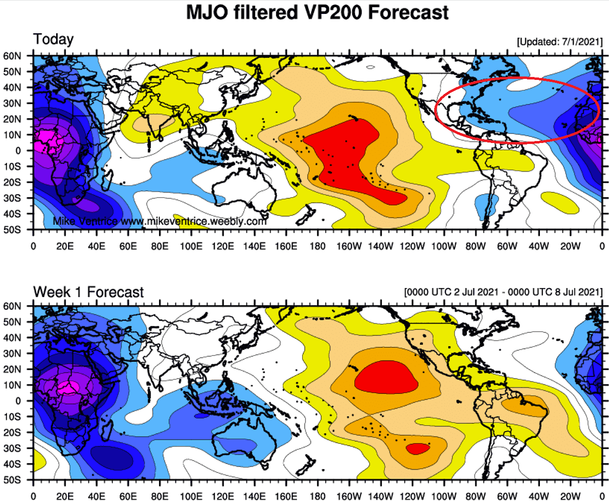
So more favorable conditions can currently be found across Central America and the Atlantic Ocean while the opposite, subsiding air masses can be found across the Pacific Ocean on the chart above.
*The VP200 indicates a Velocity Potential (VP), an indicator of the large-scale divergent upper-level flow over the tropical region. The negative VP anomalies (shaded in blue colors) are closely related to the divergent outflow from enhanced convective regions.
To conclude, the current VP200 analysis (first chart) hints that quite favorable conditions remain across the western tropical Atlantic and across the Caribbean. That is why Tropical Storm Elsa was able to form with the MJO wave support and then also strengthen into a hurricane.
Over the next week, the blue colors gradually weaken while the MJO wave continues sliding east towards the eastern Atlantic. Therefore we expect that these supportive conditions should allow further development of Tropical Storm Elsa while activity in the next one or two weeks will temporarily become less favorable over the tropical Atlantic with the arrival of the subsiding part of the MJO wave.
TROPICAL STORM ELSA BECOMES THE 1st HURRICANE OF THE SEASON
Hurricane Elsa is now maintaining its strength while moving further west-northwest across the eastern Caribbean, expected to gradually continue towards Cuba. Thanks to very warmer seas and while the Saharan dust cloud is decaying over the western Atlantic region, it should begin gradually intensifying with time into the weekend.
Hurricane conditions and dangerous storm surge are expected within the Hurricane Warning areas in Haiti and the Dominican republic beginning Saturday and in Jamaica beginning Sunday.
Quite strong convective activity is being observed with the satellite imagery, cloud tops of the most robust thunderstorms are reaching up to nearly -80 °C and with improving upper-level outflow ventilation. A sign that conditions are good enough for Elsa’s survival further.

Hurricane conditions and dangerous storm surge are possible in portions of eastern Cuba beginning early Sunday where a Hurricane Watch is in effect. There is an increasing risk of wind, storm surge, and rainfall impacts elsewhere in Cuba Sunday and Monday.
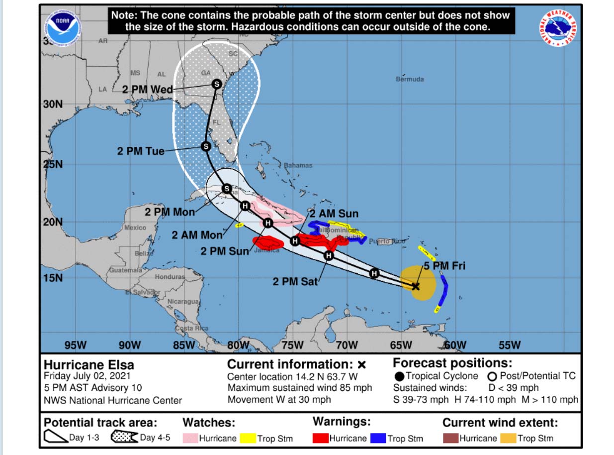
Heavy rainfall will gradually subside across the Windward and southern Leeward Islands tonight, including Barbados. Outer rain bands will impact Puerto Rico by late tonight, and affect southern Hispaniola and Jamaica Saturday into Sunday. Isolated to scattered flash flooding and mudslides are possible.
By early next week, heavy rain will impact the Cayman Islands and Cuba. Significant flooding and mudslides are possible.

There is also an enhanced risk of wind and rainfall impacts in portions of Hispaniola, Cuba, the Turks and Caicos, and the Bahamas through early next week. But the exact potential needs to be monitored further once Elsa strengthens more in the coming days.

Later on, early next week, there is a risk of storm surge, wind, and rainfall impacts in the Florida Keys and portions of the southern Florida Peninsula. But the time distance is still several days ahead, so the forecast uncertainty remains larger than usual due to Elsa’s potential interaction with the Greater Antilles this weekend.
There is an increasing risk of storm surge, wind, and rainfall impacts beginning Monday in the Florida Keys and spreading northward along the Florida Peninsula through Tuesday.
There is also a rising potential that Elsa would strengthen even further and become a Category 2 hurricane over the next days, depending on its interaction with the islands and their terrain along the storm’s path. And it may also end up turning towards the US and Florida.

Interests in Florida should monitor Elsa’s progress and updates to the forecast. Attached above are the main global models ECMWF and GFS potential tracks of Tropical Storm Elsa. Both suggest that the system would gradually continue across the northern Caribbean and could reach Cuba.
LATEST HURRICANE SEASON 2021 FORECAST
The international committee of WO, the World Meteorological Organization, has designated a list of 21 tropical cyclone names that will be in use during the Atlantic hurricane season 2021. These are starting with Ana and will end up with Wanda.
So far, four storms – Ana, Bill, Claudette, Danny, and now Elsa have formed. Elsa which formed this Thursday, July 1st, sets a new record as the earliest 5th named tropical cyclone of the Atlantic hurricane season.
Also, Tropical Storm Danny, which formed on Monday this week, helped the season to achieve some valuable reference as it means that the 2021 season is the 5th year with 3 tropical cyclone formations during the month of June. And this is a pretty rare occurrence and it shows how warm Atlantic helps to develop these early cyclone formations.

Above: Tropical Cyclone names for the hurricane season 2021
When the monitoring of tropical activity was at the beginning, the Atlantic tropical cyclone names were used from lists originated by the National Hurricane Center (NHC), and are in use since 1953. Now, tropical cyclone names are maintained and updated by an international committee of the WMO.
The hurricane or tropical storm name lists are used in rotation and re-cycled every six years, so the tropical cyclone names list of 2021 will again be in use in 2027.
For the Hurricane Season 2021, the NOAA’s Climate Prediction Center (CPC) is forecasting a 60% chance of above-average activity. With the potential for 13-20 named storms, Including 6-10 hurricanes and 3-5 major hurricanes (Category 3 or greater).

But also the other forecasting centers believe that the Atlantic hurricane season 2021 prediction is likely to be yet another very active one. The Colorado State University (CSU) forecast predicts 18 named storms this year while the Weather Channel (TWC) is forecasting 19 named storms. The United Kingdom’s Met Office (UKMO) about 14 named systems.
Typically, when we want to judge how strong the hurricane season is, we use the Accumulated Cyclone Energy (ACE). This is a metric that is used to express the energy being used by a tropical cyclone during its lifetime.
Recent predictions by the forecasting teams hint that the ACE index could end up around 150 during this year’s hurricane season. That is about 22 percent more than a normal season for the 1991-2020 period.
What the ACE index (Accumulated Cyclone Energy) means?
The ACE is the abbreviation for Accumulated Cyclone Energy. The metrics that we use to express the energy used by a tropical cyclone during its lifetime.
ACE represents the calculation of the tropical cyclone’s maximum sustained winds every six hours and the number is then multiplied by itself to generate the values. At the end of the tropical cyclone duration, we take the sum of these values and calculate the final ACE value for a tropical storm or a hurricane.
The calculation of the Accumulated Cyclone Energy was originally created by William Gray and his associates at Colorado State University (CSU). In the beginning, they developed a so-called Hurricane Destruction Potential index, which took each hurricane’s maximum sustained winds above 65 knots (= 75 mph or 120 km/h) and multiplied it by itself every six hours.
But two decades ago, in 2000, this index was subsequently tweaked by the NOAA researchers, so it now includes all tropical cyclones that have the maximum sustained winds above 35 knots (65 km/h = 40 mph). And to make it simpler, the ACE index was then finally renamed to an Accumulated Cyclone Energy we use nowadays.

The above graphics show the yearly values of the ACE index for the Atlantic Ocean hurricane season since the 1940s. We can quickly notice how the recent 5 years all had an above-normal value of the ACE index, which is 111. Within the Atlantic Ocean, the NOAA uses four categories to classify hurricane season by the ACE, those are:
- Extremely active – ACE index above 152.5
- Above-average – ACE index above 111
- Near-average – ACE index between 66 and 111
- Below-normal – ACE index below 66
The whole record-breaking hurricane season 2020 brought the ACE ending at 184.5, which is quite well above the threshold for the ‘extremely active’ category. This also placed the 2020 season into the TOP-10 Atlantic hurricane seasons based on the ACE index.
The record holder hurricane season with the highest ACE index remains 1933, which had the final ACE of 258. Then, the hurricane season with the 2nd most named storm formations after last year’s, 2005, also ended up extremely high, the final ACE was 250.
This gives a good presentation that although the 2020 season had a record-breaking number of tropical cyclone formations, this does not necessarily reflect an extreme final value of Accumulated Cyclone Energy.

Above: Chart indicates the recent 15 hurricane season ACE final values and the related number of hurricanes in that particular year.
The closest Atlantic hurricane season that fits into an ‘extremely active’ category can be found in 2017. And we might just add another above-normal value of the ACE index at the end of the hurricane season 2021 if the activity continues in a similar way as it started.
***The images used in this article were provided by NOAA NHC, Tropical Tidbits, and Windy.