Soon after a damaging typhoon Maysak landfall in South Korea, a Typhoon Haishen has literally exploded over the Philippine Sea. It is rapidly intensifying and heading towards Japan’s Kyushu Islands and then towards South Korea. Haishen is expected to reach a high-end Category 4 strength by Thursday night or even a Category 5 strength by Friday.
CLICK FOR UPDATED FORECAST
Typhoon Haishen is rapidly gathering strength over very warm waters south of Japan. The powerful storm is expected to approach the southwestern part of the country sometime on Sunday and Monday. It could be devastating for Kyushu Islands. Haishen will be passing close to the Daito Islands in the southernmost prefecture of Okinawa.
Impressive satellite imagery
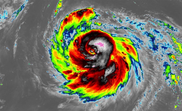
Haishen has begun its rapid intensification today, soon after the Eyewall Replacement Cycle (EWRC) was finished. There is an intense eyewall forming, while the central pressure is rapidly deepening. NASA MODIS infrared satellite scan reveals that the cloud tops temperatures are already extremely low.
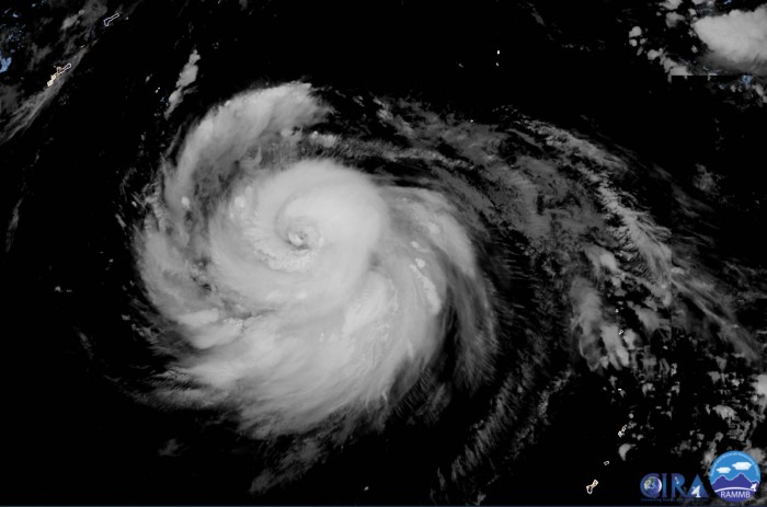
Satellite imagery reveals a classic ‘cinnamon roll’ appearance of the typhoon.
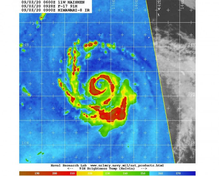
Today, we could see a textbook example of an EWRC. The microwave scans provided a very good picture of the structure of the cyclone.
A solid eyewall began shrinking during the day, while it gets surrounded by an intense convective band. With the EWRC, the inner eyewall weakened and the new, outer eyewall became stronger.
Typhoon Haishen is likely to resume its rapid intensification and is expected to become a Super Typhoon, potentially with near or even higher winds than 130 knots (150 mph).
That is a high-end Category 4 or even a Category 5 on the Saffir-Simpson scale over the net 36-48 hours.
Satellite analysis
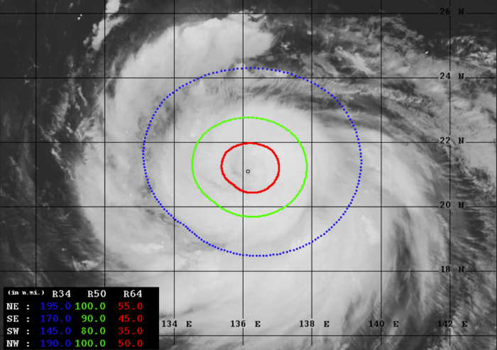
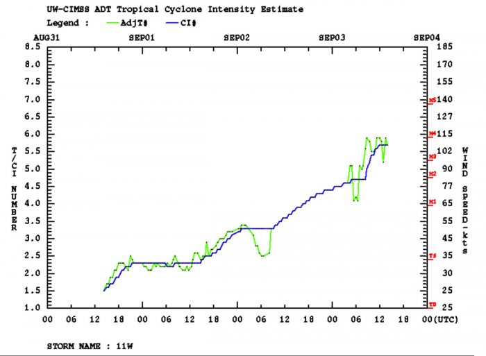
Advanced Dvorak Technique (ADT) estimates are indicating that Haishen is becoming a very powerful and large typhoon. Its tropical-storm-force 50-knot winds are spread across the 80-100 mile radii. It already has 40-60 miles radii of hurricane-force 64-knot winds. The wind field is growing.
The intensity analysis has a very nice example of a strengthening system, including its eyewall replacement cycles. One of them occurred on Wednesday from 00-06 UTC. Another one occurred today, roughly between 06-12 UTC when the intensity curve flattens.
After the last cycle, Hainsen’s strength literally exploded and is now nearing 110 knots of sustained wind speeds!
Near-record hot ocean waters
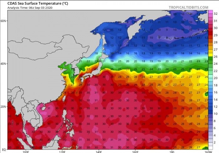
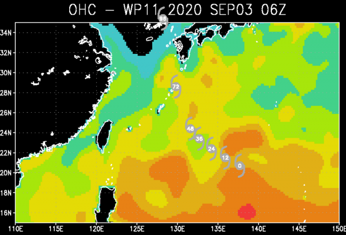
Haishen is expected to take a more easterly track than Maysak. This means is will mostly avoid the cold wake left by typhoon Maysak, therefore it remains over extremely warm, near-record hot waters for most of its lifecycle.
30-31 °C is spread across the whole western Pacific and especially warm to the south of Japan. Right where Haishen will be moving.
Typhoon should track across the extremely favorable oceanic conditions for the next 72 hours. Also, low wind shear is present ahead of the Haishen until the weekend, allowing it to continue rapidly strengthening.
Storms fueling the typhoon’s strength with these very hot, near-record values of ocean waters and moist mid-level atmosphere, should support further rapid intensification.
Forecast track for Haishen
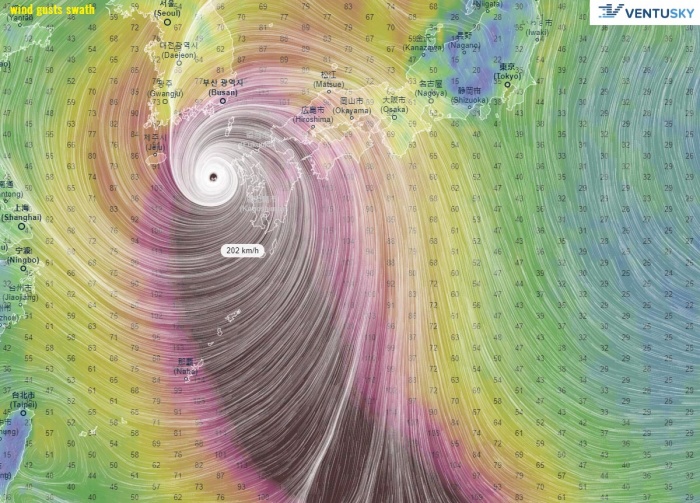
Haishen is forecast to track generally northwest for another 24 hours, then taking a more north-northwest route towards Kyushu Islands. Still, the majority of the ensemble models is tracking Haishen towards Kyushu, or very near its western coast. Nevertheless, it will be devastating for the region.
Attached is the video animation of the 10-meter winds, surface pressure, infrared satellite forecast simulation. Haishen will remain a violent storm, traveling towards the Kyushu Islands and Korean peninsula!
Rainfall & Destructive winds threat
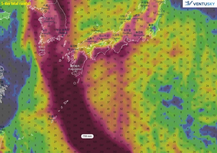
An extremely dangerous situation is developing, as Japan could be severely hit by a violent wind, storm surge, and a tremendous amount of rain with flooding.
A significant amount of rainfall is expected across the Kyushu island, and across the Korean peninsula later. Just days after Maysak’s impact. The amount of rain could locally reach 200-400 mm.
What is a typhoon
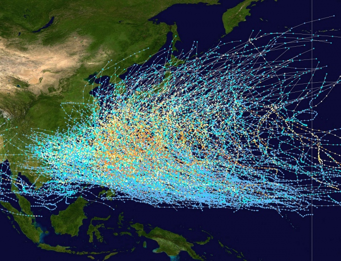
Hurricanes and Typhoons are the most powerful tropical weather events on Earth. A typhoon is a mature tropical cyclone, forming in the western Pacific (they normally develop between 100° and 180° East in the Northern Hemisphere) and heading towards Asia.
The region typhoons form is referred to as the Northwestern Pacific Basin. It is the most active tropical cyclone basin on Earth, accounting for almost one-third of the world’s annual tropical cyclones forming.
Typhoon formation
There are several ingredients that lead to tropical cyclogenesis: warm sea surface temperatures of above 26 °C, high atmospheric instability, and high humidity in the lower/middle levels of the troposphere.
And the final environmental support with upper-level divergence, supporting the upward motion for deep convective storms to develop.
At the surface, a pre-existing low-level wave or disturbance develops and moving through an environment with low vertical wind shear. A tropical cyclone gets designated to a typhoon when maximum sustained winds are above 64 knots (73 mph or 118 km/h).
If winds exceed 130 knots (150 mph or 241 km/h), the typhoon is upgraded to a Super typhoon.
Water vapor analysis of tropical cyclones indicates the potential a tropical system has to develop. Water vapor releases latent heat as it condenses into a liquid. That liquid then form clouds and thunderstorms, gradually organizing into a tropical cyclone.
Typhoons often have very high cloud tops, even below -85 °C or -90 °C some times. There is a rough projection – the higher the cloud tops, the colder and the stronger tropical cyclones are.
Typhoon frequency and tracks
On average, there are more than 26 tropical storms and typhoons every year. Systems have a general westward track towards the Philippines, southern China, Taiwan, and Vietnam.
There are some rare events than a tropical cyclone formed east of the 180° East longitude, over the central Pacific, and travel westward into the western Pacific and continue as typhoons.
RECAP: Some uncertainties remain how intense typhoon Haishen will be when approaching Kyushu Islands. However, the intensity models are hinting it is likely to be much stronger than Maysak as it passes over or very near the Kyushu Islands. Then, another severe hit to South Korea is expected.
Stay tuned for further updates over the weekend!
See the previous forecast discussion:
