Super Typhoon Haishen has been maintaining its powerful high-end Category 4 strength through Friday and Saturday. The peak sustained winds were at 155 mph (135 knots or 250 km/h). Haishen is the Earth’s 3rd strongest storm of 2020 and is expected to hit Japan and South Korea on Sunday.
CLICK FOR UPDATED FORECAST
Haishen is expected to be one of the most intense storms on record for Japan. The steongest storm ever hit Japan was a Category 5 Super Typhoon Very that struck Japan back in September 1959.
Vera holds the record of the strongest and deadliest typhoon on record to make landfall on the country.
Haishen will be set a remarkable typhoon statistic for the Korean peninsula. When Haishen makes landfall, it will be the third landfall of the typhoon in the Korean peninsula within the past 14 days. South Korea was already badly hit with Maysak a few days ago, while typhoon Bavi hit North Korea in late August.
Haishen is also the Earth’s 3rd strongest storm on record for 2020. The only two strongest systems this year were Harold (165 mph winds) and Amphan (160 mph) peak sustained winds.
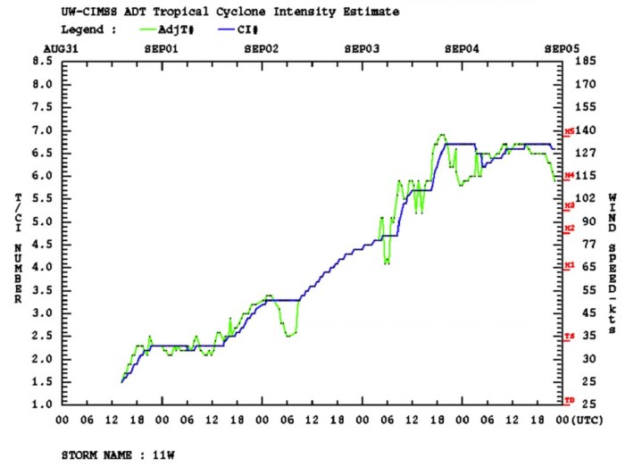
The lowest estimated central pressure during the peak intensity of Haishen has been fluctuating between 915 and 925 mbar, according to Dvorak ADT satellite analysis. Haishen intensified from 85 knots to 135 knots in 24 hours (between 00 UTC Sept 3rd to 00 UTC Sept 4th).
Record-high warm seas near Japan
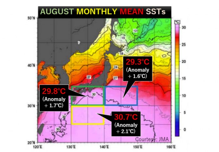
The sea surface temperatures south of Japan are the highest ever observed since the records began in the year 1982. Temperatures are roughly 2 degrees Celsius (4F) higher than normal there.
The above graphics by Japan Meteorological Agency (JMA) indicates that the average temperature of the sea just south of Japan has been at 29.8 °C through August. About 1.7 °C above the long-term average.
Even warmer, 2.1 °C above the average, were the temperatures further south. Directly in the area (between 130-140° E and 25-30° N) where Haishen is tracking this weekend, nearing Japan islands.
This is the main reason why typhoon Haishen has literally exploded in intensity on Thursday. Being within a very low shear environment, oceanic conditions lead to very rapid intensification.
Outstanding satellite presentation
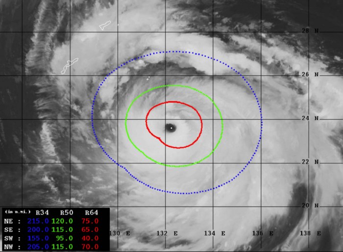
Haishen has gone through a very rapid intensification on Thursday, which began soon after the Eyewall Replacement Cycle (EWRC) was finished. A very large eye has appeared, with the central pressure rapidly deepening into 915 to 920 mbar range.
NASA MODIS infrared satellite scan reveals that the cloud tops temperatures were extremely low. Occasionally, the cloud tops temperature was near -90 °C. This often happens with the most intense tropical systems on Earth.
Advanced Dvorak Technique (ADT) estimates are indicating that Haishen is an extremely powerful and very large typhoon. Its tropical-storm-force 50-knot winds are spread across the 100-130 mile radii. It already has 40-75 miles radii of hurricane-force 64-knot winds.
Destructive impact for Japan islands
The first effect for any land areas will be the small Japanese island Minamidaitōjima. Nearly 2000 population on the island will experience a full force of this violent typhoon tonight.
Very significant damage is expected on the island. Especially as major storm surge and flooding are likely as well.
Just hours later, Haishen is expected to pass near the Japanese island of Amami Oshima, around 150 km northeast of Okinawa. A typhoon chaser James Reynolds is reporting from there.
Haishen seems to be taking a more westerly track that it was previously anticipated. Therefore, a direct landfall in Japan’s Kyushu Island is becoming unlikely. Nevertheless, Haisen’s size and violent strength are huge, so it will be devastating there as well.
After the typhoon enters the northeast region of the East China Sea, Haishen will likely graze into the cold wake left behind the Typhoon Maysak. This could cause a faster weakening of the storm, moving towards South Korea on Sunday.
After Japan, Haishen heads for Korea
The landfall of typhoon Haishen in Korea will be historic and record-breaking. No season over the last 75 years has seen three typhoons making landfall anywhere on the Korean peninsula.
Actually, only named 14 typhoons have passed over South Korea prior to 2020. Only three typhoons passed over North Korea prior to 2020.
Here is the animation of typhoon Haishen winds along with its final days tracking across Amami Oshima, Kyushu islands and further towards the landfall in South Korea:
Rainfall and flooding threat
An extremely dangerous situation is developing, as both Japan and Korea will be severely hit by an excessive amount of rain. The widespread 200-400 mm of rain is likely along Haishen’s track. With a much above normal wet monsoon season in Korea, additional deadly flooding threat is expected.
A significant amount of rainfall is expected across the Amami Oshima, Kyushu islands, and across the Korean peninsula afterward. Just days after Maysak’s impact. The amount of rain will be extreme and flooding/landslides are very likely to occur.
Typhoon – the strongest storms on Earth
A typhoon is a mature tropical cyclone, forming in the western Pacific (between 100° and 180° East in the Northern Hemisphere). Typhoons are, besides hurricanes, the most powerful tropical weather events on Earth.
The region where typhoons form is known as the Northwestern Pacific Basin. It is the most active tropical cyclone basin on Earth, accounting for almost one-third of the world’s annual tropical cyclones forming.
Typhoon needs warm water and high humidity to form
Very warm to hot sea surface temperatures of above 26 °C, high atmospheric instability, and high humidity in the lower to middle levels of the troposphere are the most important ingredients that lead to tropical cyclogenesis.
The final ingredient is environmental support, the upper-level divergence. This is a very important factor as it is supporting the upward motion for deep convective storms to develop.
At the surface, a pre-existing low-level wave or disturbance develops and moving through an environment with low vertical wind shear.
A tropical cyclone gets designated to a typhoon when maximum sustained winds are above 64 knots (73 mph or 118 km/h). If winds exceed 130 knots (150 mph or 241 km/h), the typhoon is upgraded to a Super typhoon.
Water vapor analysis of tropical cyclones indicates the potential a tropical system has to develop. Water vapor releases latent heat as it condenses into a liquid. That liquid then form clouds and thunderstorms, gradually organizing into a tropical cyclone.
Typhoons often have very high cloud tops, even below -85 °C or -90 °C at times. There is a rough estimation – the higher the cloud tops, the colder and the stronger tropical cyclones are.
Typhoon frequency and tracks
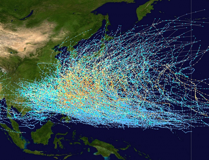
On average, there are more than 26 tropical storms and typhoons every year. These systems have a general westward track towards the Philippines, southern China, Taiwan, and Vietnam.
There are some rare events than a tropical cyclone formed east of the 180° East longitude, over the central Pacific, as a tropical storm or a hurricane. When it travels westward into the western Pacific, it continues as a typhoon.
Conclusion
Typhoon Haishen will remain a very intense system while tracking across the Minamidaitōjima island tonight. The next in line are Amami Oshima islands, to the northeast of Okinawa. Destructive winds, storm surge, and flooding are expected.
Haishen is expected to be one of the most intense storms to hit Japan on record.
Some uncertainties still remain how intense Haishen will be when approaching Kyushu Island, Japan on Sunday. Then, another severely damaging and historic impact on South Korea is expected.
Stay tuned for further updates over the weekend!


