Northeast India and the city of Kolkata are in the path of a new dangerous Tropical Cyclone Yaas this week. An extreme amount of rainfall will cause major flooding, while also storm surges, and damaging winds are expected near the landfall point.
Just a week after a devastating Tropical Cyclone Tauktae made landfall in the Gujarat state, northwest India, the country is facing another potentially damaging storm. According to local media, at least 122 people lost their lives, related to the cyclone Tauktae last week. Including members from the ship that sank off the coast of Mumbai.
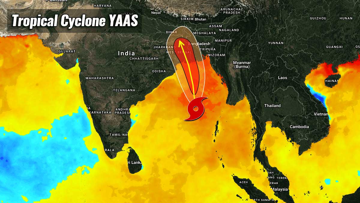
The new cyclonic storm Yaas (pronounced as ‘Yass’) is located over the east-central Bay of Bengal. It will intensify into a severe cyclonic storm in the next 24 hours and likely to become a Very Severe Cyclonic Storm during the subsequent 24 hours, based on the Indian scale for a tropical cyclone classification, and made landfall around noon on Wednesday, May 26th.
NORTH INDIAN OCEAN TROPICAL CYCLONE SEASON
When a tropical cyclone forms in the North Indian Ocean, it is monitored by the Indian Meteorological Department (IMD) which classifies the systems with their own intensity scale. The strongest events are classified as Super Cyclonic Storms, e.g. Super Cyclonic Storm Tauktae last week.
- Cyclonic Storm – winds between 34 and 47 knots (or 63 and 88 km/h)
- Severe Cyclonic Storm – winds between 48 and 63 knots (or 89 to 117 km/h)
- Very Severe Cyclonic Storm – winds between 64 and 89 knots (or 118 and 165 km/h)
- Extremely Severe Cyclonic Storm – winds between 90 and 119 knots (or 166 and 220 km/h)
- Super Cyclonic Storm – winds above 120 knots (or 221 km/h)
In the Indian Ocean north of the equator, tropical cyclone formations can happen throughout the year on either side of India. The Bay of Bengal on the east side, and the Arabian Sea on the west side of India.
There are two periods with the more frequent tropical occurrences, one is between April and June, and another one between October and December. So basically before the Indian monsoon starts and after it ends.
Sometimes, two systems can develop in the North Indian Ocean basin, ongoing simultaneously. Below is such an example of two very severe cyclonic storms (Luban and Titli) grazing across the Arabian Sea and the Bay of Bengal in October 2018.

The Bay of Bengal, located in the northeast of the Indian Ocean, is responsible for some of the strongest and deadliest tropical cyclone formations in the world. The most intense tropical cyclone in the bay was the Odisha cyclone in 1999. While the deadliest cyclone in the Bay of Bengal remains the 1970 Bhola Cyclone. The costliest storm in the region was Cyclone Amphan in May 2020.
*******
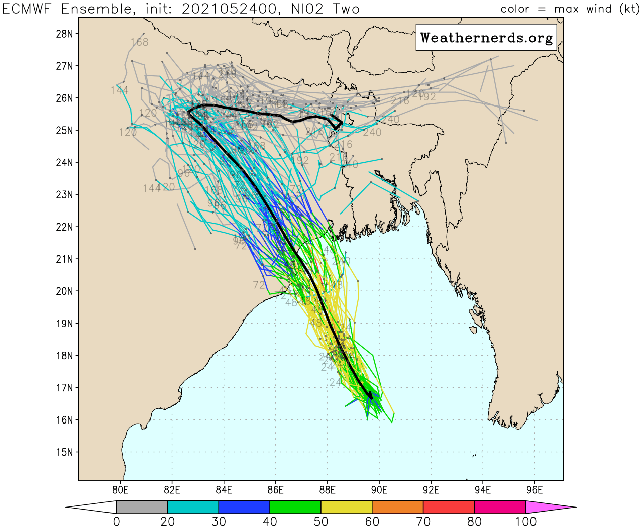
The current tropical cyclone Yaas has the maximum sustained winds of 35 knots and a central pressure of around 990 mbar, while continues strengthening. Yaas will reach Northwest Bay of Bengal near north Odisha and West Bengal coasts by May 26th early morning. Below is the animation of the system tracking towards its landfall this week.
Yaas is very likely to cross north Odisha-West Bengal coasts between Paradip and Sagar islands around noon of May 26th, with intensity as a very severe cyclonic storm.
TROPICAL CYCLONE INTENSIFYING IN THE BAY OF BENGAL
The strongly organizing new Tropical Cyclone #02b or Yaas is located approximately 300 nautical miles south-southeast of Kolkata, India, and has tracked northward at about 6 knots this Monday.

The animated multispectral satellite imagery depicts a consolidating but broad, partly exposed low-level circulation with a wide swath of deep convective banding over the western semicircle of the system. The initial position is based on the broad but defined center in the satellite imagery.
The initial intensity is based on the Dvorak estimate of T2.5 and 35 knots. Yaas is currently in a marginally favorable environment with moderate vertical wind shear (15-25 knots) offset by robust equatorward upper-level outflow ventilation aloft.
A very warm to even hot waters of 30-32 °C sea surface temperatures area spread over the North Indian Ocean. These temperatures are much above the long-term 1981-2010 climatological average in the region. They are around 2-3 °C warmer than normal across the North Indian Ocean, as well as further east across the South China Sea.

This also means that tropical cyclones have much more energy available to feed the storms and become more violent and destructive as they reach the land.
The new system will remain in a marginal environment for the next 24 hours as it tracks north-northwestward around a subtropical ridge to the northeast. But after tonight (Monday night), the vertical wind shear is forecast to decrease. This will allow Tropical Cyclone Yaas to reach a peak intensity of around 80 knots prior to making landfall southwest of Kolkata on Wednesday.
The Ocean Heat Content (OHC) map indicates that Yaas is now moving across healthy ocean waters to support its further strengthening over the next 36-48 hours until the landfall occurs.

The OHC is defined as the integrated temperature change times the density of seawater, times specific heat capacity from the surface down to the deep ocean. In oceanography and climatology, Ocean Heat Content is a term for the energy absorbed by the ocean.
CYCLONE YAAS LANDFALL SOUTHWEST OF KOLKATA, INDIA
Tropical Cyclone Yaas is the third tropical depression, and also the second deep depression (officially Cyclonic Storm) of the 2021 North Indian Ocean tropical cyclone season. Yaas formed from a tropical disturbance, and the Indian Meteorological Department started to monitor it on May 23rd (Sunday).
The environmental conditions in the Indian Ocean basin favored development over the weekend. The new system became a deep depression by Sunday and already intensified into a cyclonic storm on Monday, being named Yaas.
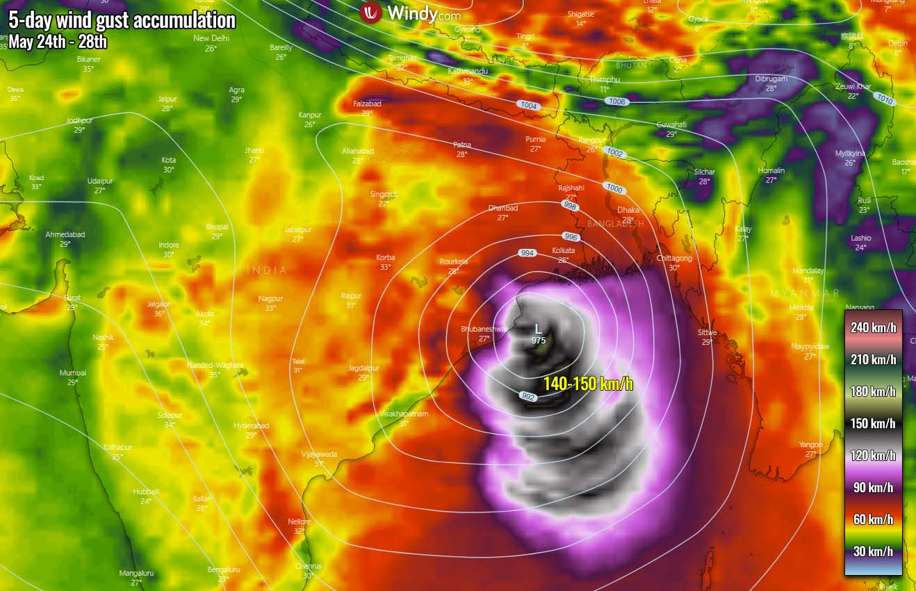
According to the Indian Meteorological Department (IMD), Yaas is very likely to continue to move north-northwestwards, intensify further and reach the northwest Bay of Bengal near north Odisha and West Bengal coasts by May 26th early morning.
IMD has upgraded the port warning particularly for Paradip and Dhamra in Odisha.
As Cyclone Yaas approaches Odisha and West Bengal coasts, the East Coast Railway has canceled 90 trains running on this route. The authorities will likely cancel more scheduled trains through Monday night as Cyclone Yaas gains momentum before intensifying into a severe storm on Tuesday.
Wind warnings for the most affected districts, including Kendrapada, Jagatsinghpur, Balasore, and Bhadrak, have been upgraded. The wind speed will be around 150-160 km/h, gusting up to 180 km/h during the landfall of Tropical Cyclone Yaas on Wednesday. Downed trees and power outages are very likely to occur.
After the landfall, Yaas is likely to rapidly weaken with dissipation by about Friday, tracking north-northwest across northeast India.
Yaas will also produce an extreme amount of rainfall, with a combination of both very heavy and excessive rain. The swath will spread further inland with additional flooding threats from the coast and along its track towards the north-northwest. Although the highest amounts of rain are likely to stay west of Kolkata, a lot of rain should also spread across the major city area.
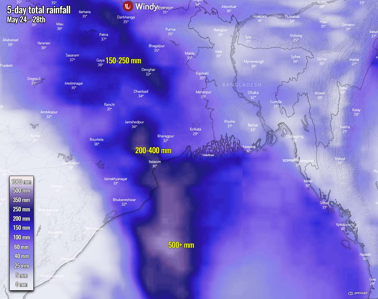
Besides the dangerous flash floods, mudslides are also likely to occur. While along the coast to the east of Yaa’s landfall, storm surge will combine with heavy rains and lead to coastal flooding.
***The images used in this article were provided by Wxcharts, NOAA, and Windy.
Also, if you have seen this article in the Google App (Discover) feed, click the like (♥) button to see more of our forecasts and our latest articles on weather and nature in general.
SEE ALSO: