We are at the peak of the hurricane season, and we are already looking ahead at the possibility of new storms developing. We already talked today about the Tropical depression 9 forming, but now we also have Invest-96L, which is an area of deep convection, but could soon become a tropical storm.
Invest-96L is currently just an area under observation, but it shows strong signs of potential development. There is deep convection already present, and it is currently moving west into more favorable conditions for further development.
IR satellite imagery of Invest-96L area. Image by Tropical Tidbits.
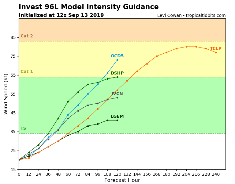
It is not easy for models to forecast this development, since there is no well defined center of low pressure and circulation. Still, first model forecasts are hinting at the next tropical storm, and soon a hurricane.
Multi-model forecast for Invest-96L area. Image by Tropical Tidbits.
Sea surface temperatures are warmer than normal, which will help in the development of this convective system. Image by Tropical Tidbits.
Looking at the global models, we have GFS that is forecasting this system to become a major (category 3) hurricane as it moves west, impacting the eastern Caribbeans next week. Image by Tropical Tidbits.
We well keep a close look on this area as it has a lot of potential for development, so stay tuned!


