After the record-breaking Atlantic hurricane season last year, it appears likely that 2021 is in for the sixth consecutive above-average year. First predictions have been released, and the message is straightforward: Yet another very active hurricane season is expected in 2021. With a quite concerning notice that also an above-average probability of hurricane landfalls along the US coastline and in the Caribbean is likely.
The upcoming 2021 Atlantic hurricane season is once again anticipating an active year. After such an active and devastating record number of named storms and destructive hurricanes, this year is expected to bring much above normal activity again.
One of the most recognized and trusted hurricane season early predictions is made by the Colorado State University (CSU) team of scientists, led by Dr. Phil Klotzbach. For 2021, the CSU team calls for 17 named tropical cyclone formations, including 8 hurricanes and also the striking 4 major hurricanes.
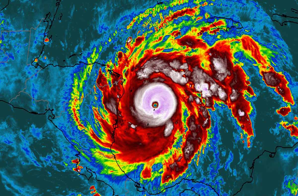
Note: an average hurricane season normally produces 14 named storms, 7 hurricanes, and 3 major hurricanes. The image below is the infrared satellite view of a Category 5 hurricane Iota in mid-November last year.
The official Atlantic hurricane season runs from June 1st through November 30th. The Atlantic basin covers the area which includes the entire Atlantic Ocean, the Gulf of Mexico, and the Caribbean Sea. The long-term average (taken over the last 70 years – between 1951 and 2019) of named storms is 11. The short-term average (taken over the last 15 years – between 1995 and 2019) is 14 named storms.
Thanks to the ongoing La Nina global weather pattern and well-above-average Atlantic sea temperatures, including the Caribbean and the Gulf temperatures, the upcoming hurricane season is expected to be rough. Although the tropical Pacific Ocean waters are gradually warming up now, weak La Nina is expected to continue until early summer this year, with ENSO conditions revert to neutral a month or two later.
Attached below is the video animation of the Atlantic sea temperature anomaly over the last couple of months. It is an obvious sign that most of the Atlantic, the Caribbean, and the Gulf is quite warmer than normal. Notice also that the temperatures in the region known as MDR (main development region – between Africa and the Caribbean Sea) are warmer than average. This hints that upcoming tropical cyclone formation will easily fuel from the very warm ocean waters.
For a hurricane to organize and gain strength, the weather conditions have to be just right. Normally, hurricanes like low-shear environments with a lot of warm/hot sea waters which bring plenty of very moist air mass. And La Nina (negative ENSO phase) helps those to maintain and develop.
The very concerning part of the forecast for the upcoming hurricane season is the high chance (almost 70 percent) of a major hurricane landfall along the United States coastline, and nearly 60 percent for the Caribbean. A typical season has about fifty-fifty probability of the US mainland getting hit. Something to consider and be hurricane aware of as we enter the new Atlantic hurricane season in less than a month and a half from now.
Such forecast is surely not something the residents of the US Gulf Coast and the Caribbean region want to hear. Not after such a devastating and record-breaking Atlantic hurricane season in recent years. Let’s just remember a devastating hurricane Laura in Louisiana, or Eta and Iota in central America, or also a destructive hurricane Michael in 2018.
2020 ATLANTIC HURRICANE SEASON WAS EXCEPTIONAL, COULD IT REPEAT THIS YEAR?
If we remember the 2020 Atlantic hurricane season, it was setting record after record with so many storms forming. It was almost too hard to keep track of all the activity. The 2020 storms have used all the designated tropical cyclone names and dug deep into the Greek Alphabet storm names.
And to top those numbers, a record-breaking 11 storms made landfall in the United States, including 6 hurricanes. Those were Hanna, Isaias, Laura, Sally, Delta, and Zeta.
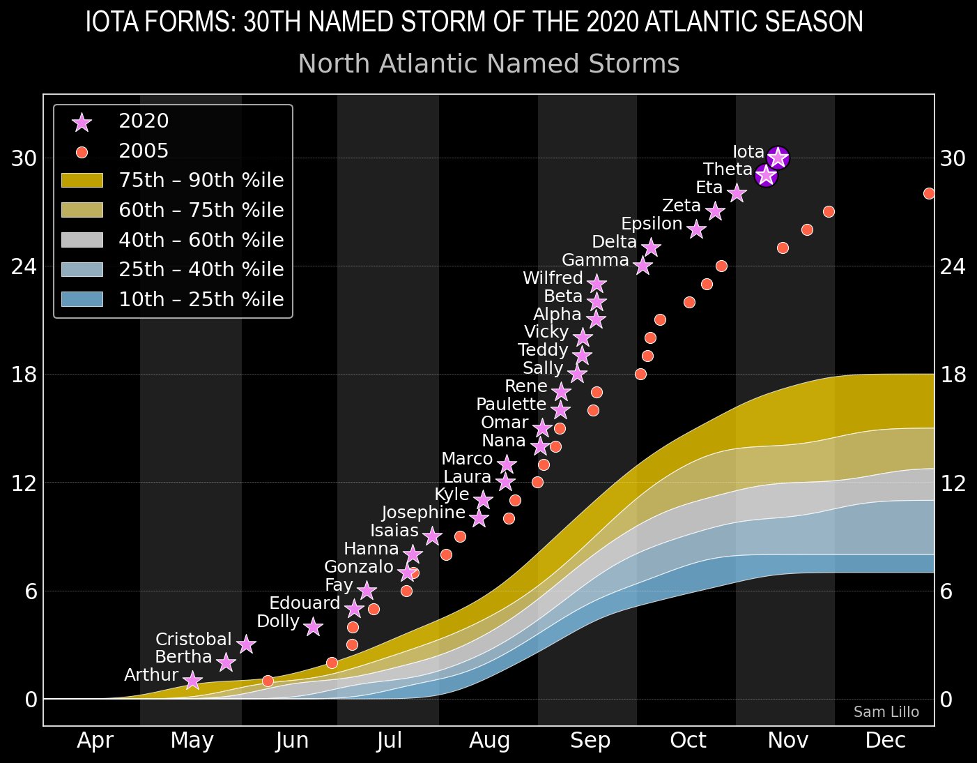
Last year has reached an unpreceded 30 named storms, an absolute record-breaking number of storms in one season. The final storm was a Major hurricane Iota which has become the first and also the only Category 5 storm of the Atlantic hurricane season 2020.
It peaked in the middle of the western Caribbean Sea but made a catastrophic landfall in Nicaragua, Central America on Nov 16th. It even set the lowest pressure of the whole hurricane season – 917 mbar during its peak strength while undergoing rapid intensification with the maximum sustained winds of 160 mph.
Hurricane Iota was the 13th hurricane and the 6th major hurricane, also the latest Atlantic calendar year Category 5 hurricane on record. And at the same time, it was the 2nd major hurricane to form in November 2020, soon after hurricane Eta. There are no hurricane seasons on record that have had two major hurricane formations in the month of November!
The most notable US mainland landfall was made by the high-end Category 4 hurricane Laura at the end of August 2020. It was the strongest landfall for Louisiana over more than 150 years, with catastrophic winds, storm surge, and flooding along the coastline.

Laura was also the 2nd deadliest storm of the 2020 hurricane season, with 77 reported fatalities along its path from Haiti to Louisiana and Texas. The deadliest hurricane was Eta with a death toll of 211 across Guatemala, Honduras, and Mexico in early November. The third deadliest hurricane was Iota, with officially 61 reported fatalities.
Iota was also the record-breaking 9th named storm from the Greek alphabet list, ending the list well above the previous record of 6 named storms, set back in the Atlantic hurricane season 2005.
Below are the designated names reserved for the 2021 Atlantic hurricane season, these include 21 names starting with Ana and ending with Wanda. The Atlantic tropical cyclones had been named from lists originated by the National Hurricane Center, and are in use since 1953.
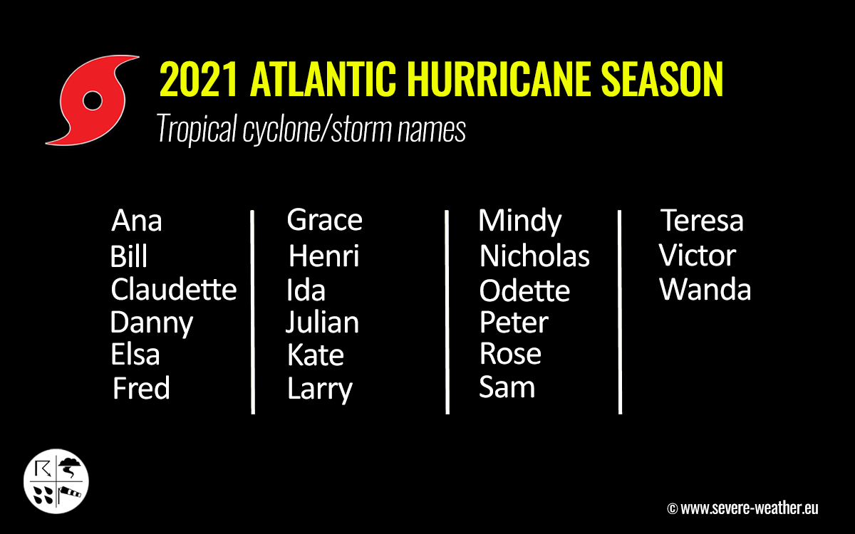
Tropical cyclone names are maintained and updated by an international committee of the World Meteorological Organization. The hurricane name lists are used in rotation and re-cycled every six years. So the list used in the 2021 year will be used again in 2027.
With CSU predicting an above-average number of tropical storms and hurricanes this year, also the ACE index is forecast to be very high. ACE is known as the Accumulated Cyclone Energy – in other words, how much energy storms produce. The CSU predicts an ACE of 150, which is well above the average for a hurricane season.
What is an ACE index – Accumulated Cyclone Energy?
The Accumulated Cyclone Energy (ACE) is a metric that is used to express the energy used by a tropical cyclone during its lifetime. The calculation takes a tropical cyclone’s maximum sustained winds every six hours and multiplies it by itself to generate the values.
The total sum of these values is calculated to get the total for a storm and can either be divided by 10,000 to make them more manageable or added to other totals in order to work out a total for a particular group of storms.
The calculation was originally created by William Gray and his associates at Colorado State University as the Hurricane Destruction Potential index, which took each hurricane’s maximum sustained winds above 65 knots (120 km/h = 75 mph) and multiplied it by itself every six hours. This index was subsequently tweaked by the NOAA in 2000 so it includes all tropical cyclones, with winds above 35 knots (65 km/h = 40 mph) and renamed to Accumulated Cyclone Energy.
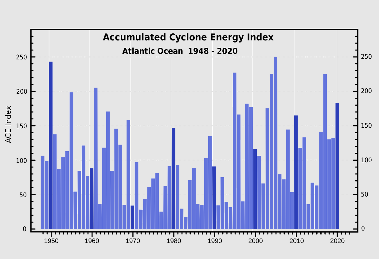
Within the Atlantic Ocean, the NOAA uses the ACE index to classify hurricane seasons into four categories.
Extremely active – ACE index above 152.5
Above-average – ACE index above 111
Near-average – ACE index between 66 and 111
Below-normal – ACE index below 66
For instance, the 2020 Atlantic hurricane season ended up at 184.5 ACE, so quite well above the threshold for the ‘extremely active’ category. This placed 2020 into the Top-10 Atlantic hurricane seasons based on the Accumulated Cyclone Energy index. The record holder hurricane season is still 1933, with an ACE of more than 258. 2005 hurricane season, the one with the 2nd most named storms after 2020, also ended up extremely high – ACE of 250.
So as we can see, although the 2020 hurricane season was so extremely active and had a record-breaking number of tropical cyclone formations and hurricanes, it doesn’t necessarily mean the Accumulated Cyclone Energy would be off the charts as well. The closest hurricane season, fitting into an ‘extremely active’ category in recent years was 2017.
And many of those well-above-average years happened during the La Nina years. If we take a look through the last 20 years, 2020, 2017, 2010, 2008, 2005, etc. were all during La Nina or Neutral ENSO years. Note: ENSO is the abbreviation for El Niño–Southern Oscillation. A periodic variation in winds and sea surface temperatures over the tropical eastern Pacific Ocean, affecting the climate of much of the tropics and subtropical regions around the world.
LA NINA ENDS BY EARLY SUMMER, NEUTRAL ENSO THROUGH THE HURRICANE SEASON PEAK MONTHS
The El Niño–Southern Oscillation (ENSO) is a region in the eastern tropical Pacific ocean, which alternates between cold and warm phases. The tropical trade winds (easterly winds that circle the Earth near the equator) usually initiate or stop a certain phase, as they mix the ocean surface waters and alter the ocean currents.
La Niña is the periodic cooling of the tropical eastern and central Pacific oceans. When sea surface temperatures are cooler than average by at least 0.5 °C, La Niña is considered to be present.

The cold ENSO phase is called La Nina, while the warm phase is known as El Nino. Each ENSO phase has a different influence on tropical weather and how it impacts the weather worldwide. Speaking of the influence on hurricane season, La Nina is its booster, while El Nino keeps the activity lower.
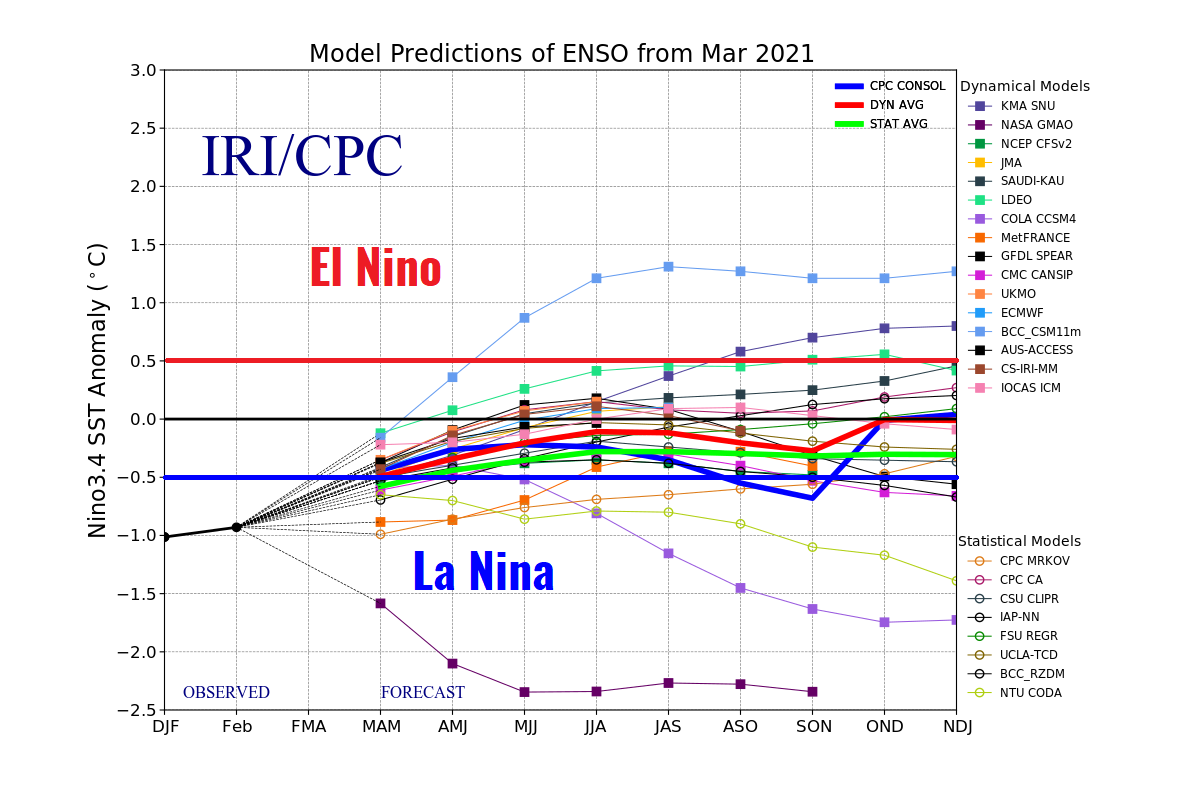
According to the IRI forecast chart of the ENSO for 2021, the cooler tropical Pacific will continue at least until early summer. A pattern is known as La Nina. Then, the Pacific Ocean is forecast to warm up into normal sea temperatures, so the ENSO would become more neutral than it is currently.
La Nina typically means that the Atlantic hurricane season becomes active, potentially even very active. Let’s just remember the 2020 hurricane season again. That was a textbook year with a combination of strong La Nina (actually it was the strongest in the last 10 years) and very warm Atlantic sea temperatures throughout all year.
And although La Nina is forecast to generally fade by early to mid-summer this year, the opposite phase El Nino will not arrive until probably the end of 2021. So the upcoming hurricane season will experience La Nina in the beginning and neutral ENSO conditions through the peak active months.
The lack of El Nino is surely a great concern, as numbers are screaming to the well-above-average to potentially even extremely active Atlantic hurricane season 2021.
SUMMARY: LA NINA AND WARM ATLANTIC SHOULD BRING VERY ACTIVE 2021 HURRICANE SEASON
So besides the likelihood of La Nina or at least ENSO neutral phase this upcoming hurricane season, the other very important ingredient is the seawater temperature across the tropical Atlantic, the Caribbean region, and also the Gulf of Mexico.
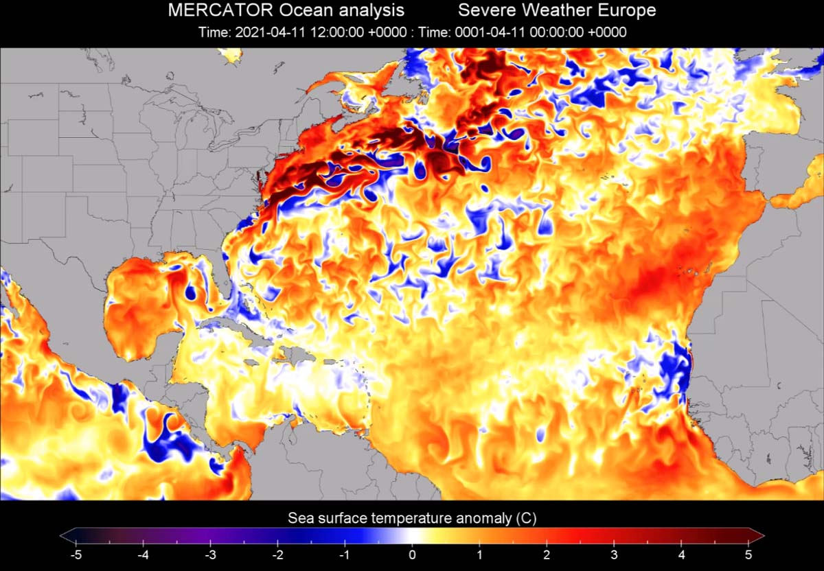
Much of the Atlantic Basin already is warmer than average, particularly near Bermuda and even extremely warm off the Northeast coast. A large part of the Gulf of Mexico is also warmer than average, and so is the tropical central and western Atlantic region. This actually correlates well with what is typically seen prior to active Atlantic hurricane season.
According to dr. Phil Klotzbach, the Colorado State University (CSU) predicts 17 named storms with the Atlantic hurricane season 2021. That is 40 percent (5 named storms) more than an average hurricane season. The climatology data takes the period between 1981 and 2010.
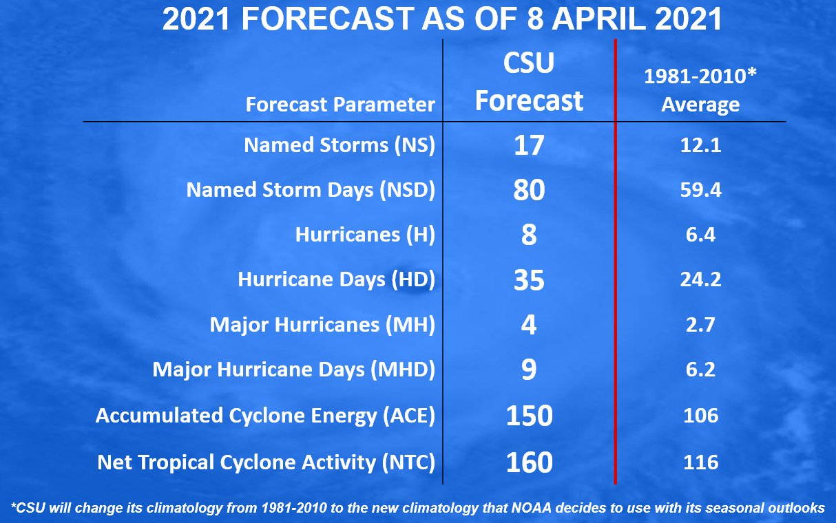
Basically, all the parameters that are typically monitored during a hurricane season are likely to be above average this year. CSU predicts about 80 named storm days (35 % above average), 8 hurricanes (25 % above average), and 4 major hurricanes (48 % above average). The Accumulated Cyclone Energy (ACE) could hit 150 which is 42 % above the normal for the 1981-2010 period.
So as we can see, the group of forecasters, led by dr. Klotzbach is forecasting a very serious outcome of the upcoming Atlantic hurricane season. Residents of the coastal areas should always be hurricane aware, no matter the forecast.

Our team will be actively following the tropical region activity worldwide, including Atlantic Basin systems and tropical cyclones that are likely to affect both the United States and Europe again this year. So stay tuned for further follow-up posts, forecast discussions, and nowcasting during the coming weeks and throughout the upcoming Atlantic hurricane season 2021.
Don’t forget to bookmark our page to have all the new info ready at hand. Or click on ‘show more‘ if you are reading this article from the Google Discover feed.