A rapidly developing Tropical Cyclone Niran has strengthened to a Category 5 system this Friday and became one of the strongest storms ever recorded over the Southwest Pacific. The last tropical cyclone that got even close to New Caledonia was a Category 4 Cyclone Erica back in 2003.
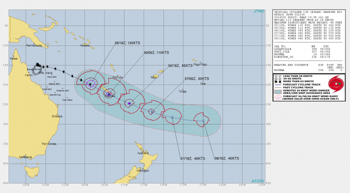
According to the latest JTWC analysis, the tropical cyclone Niran was located approximately 300 miles west-northwest of Noumea, New Caledonia. It has tracked east-southeastward at a forward speed of around 24 knots over the past six hours.
Niran is now moving towards its potentially destructive landfall in New Caledonia later today. Another monster storm is grazing the Indian Sea, with a *very* impressive structure of a violent tropical system. It has a designated name Habana.
Similar to Niran, Tropical Cyclone Habana has also reached an impressive near 140 mph maximum sustained winds this Saturday morning.
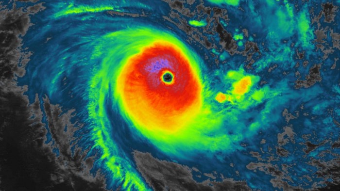
The animated enhanced infrared satellite imagery of Cyclone Niran reveals a 12 nautical miles eye with cooling cloud top temperatures surrounded by a weakening convective structure.
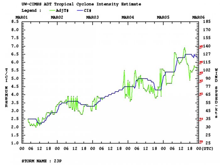
The initial intensity of 130 knots (150 mph) is hedged at Dvorak’s current intensity estimates of T7.0 (140 knots = 160 mph).
Niran will bring life-threatening coastal flooding and damaging winds across much of New Caledonia on Saturday.
TROPICAL CYCLONE NIRAN PEAKS AS CATEGORY 5
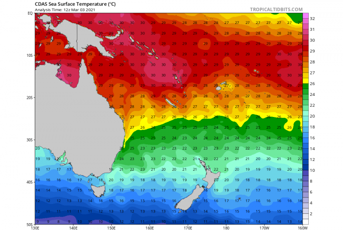
The environmental conditions remain impressive over the tropical region north and northeast of Australia lately. There are hot sea temperature waters of 30-31 °C over the Gulf of Carpentaria as well as around Papua New Guinea and towards Vanuatu. But also around 29 °C over the Coral Sea, between the coast of Queensland and New Caledonia.
The above-normal sea temperature combined with the low vertical wind shear, leading to a formation of a compact and powerful Tropical Cyclone Niran. Those temperatures are about 1-1.5 °C warmer than usual early March seas. Such conditions normally bring explosive strengthening of the systems.
The favorable environment has improved significantly overnight to Friday, allowing Niran to track into the better upper-level outflow. The system has intensified even more than all-weather models were predicted.
Tropical Cyclone Niran has peaked at the maximum sustained winds of 160mph and a central pressure of 917 mbar on Friday afternoon. It has been upgraded to the maximum, Category 5 tropical cyclone. Its trajectory has turned towards New Caledonia where a destructive landfall is increasingly likely today, Saturday, March 6th.
Niran has revealed an impressive satellite presentation with a pinhole eye, barreling towards New Caledonia as a Category 5 through Friday night.
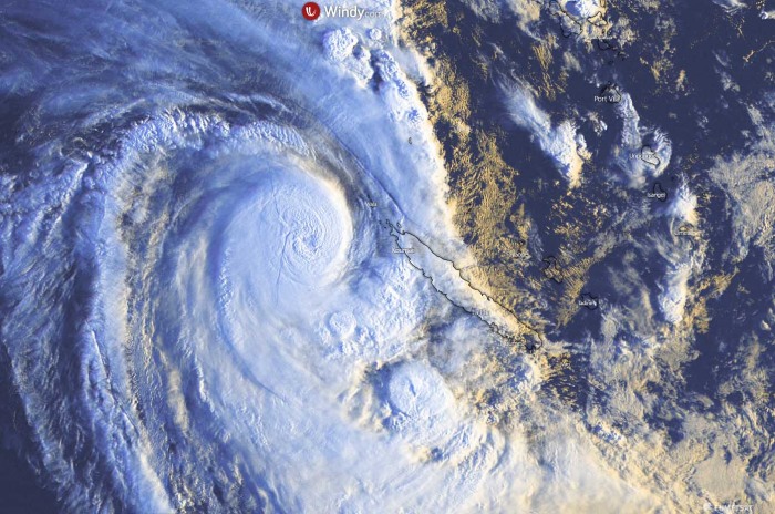
The visible satellite image above reveals the first Saturday morning light over Niran, revealing that the cyclone Niran continues racing east-southeast towards its impact on New Caledonia. The recent satellite imagery suggests that some structural deterioration has occurred, so the system is gradually beginning its weakening phase. But it remains a very intense and destructive cyclone.
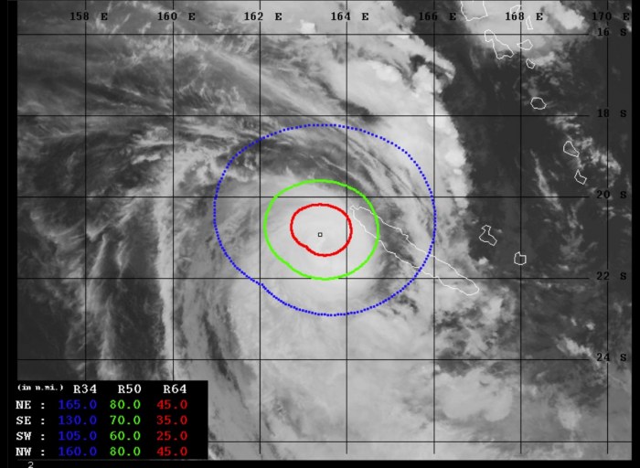
The winds in the core of the cyclone were already reaching hurricane-force-winds Thursday, expanded in size and intensity on Friday into this Saturday morning. The 64-knots wind radii are expanding 25-45 miles around the center of the low.
With the tropical-storm-force of 50-knots spread across the wind radii of 60-80 knots around the core. These winds are already affecting northern portions of New Caledonia, and will gradually intensify and spread across the country over the next 12-24 hours. Those will locally be very damaging.
Looking over the intensity analysis of Niran, we can see that the system has been strengthening since its birth earlier this week but has really ramped up from the local Friday morning onward. The peak was at T7.0 and 140 knots (160 mph) around 12-15 UTC on Friday, early morning Saturday local time.
DESTRUCTIVE LANDFALL OF NIRAN TO NEW CALEDONIA
Niran will pass very near the west coast of New Caledonia and could make landfall near the city of Noumea (population of approx. 94.000) in the southwestern portions of the country later today.
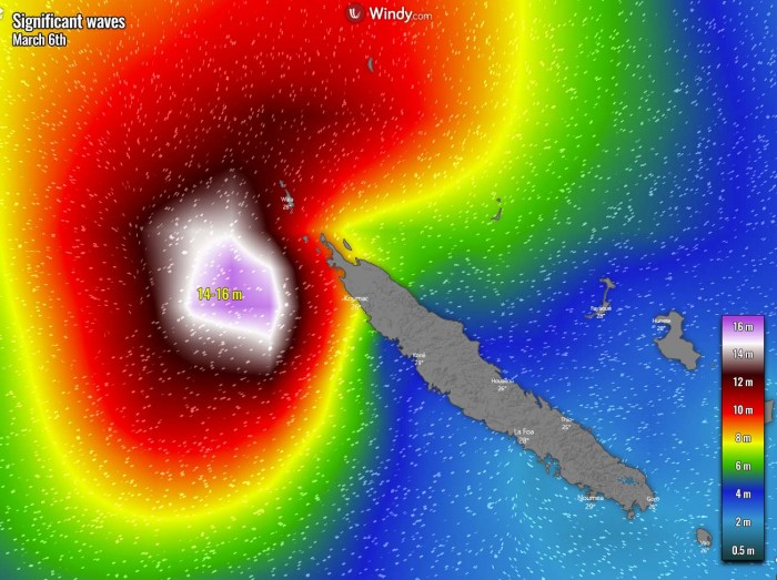
Major waves of potentially more than 15-meter heights are spreading towards the north-northwestern coastal areas this Saturday morning. A damaging storm surge is likely to occur.
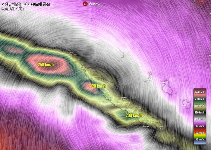
The forecast of the wind gusts chart for Saturday morning hints at the potential position of Tropical Cyclone Niran, located just at the coast of west-central New Caledonia. Destructive winds, storm surge, and flooding are expected all along the western coast.
The highest gusts could locally exceed 200 km/h.
Tropical Cyclone Niran is expected to maintain this southeastward track through late Sunday where it turns to a generally eastward track. At the same time, Niran will begin a subtropical transition as it approaches the cold baroclinic zone and become a fully subtropical system on Monday.
After Niran’s landfall in New Caledonia, the system will continue tracking east-southeast while weakening. It will dissipate late next week further southeast of the country.
See the initial forecast discussion:
The explosive development of a dangerous Tropical Cyclone Niran along northeast Queensland, Australia. Heads for New Caledonia
***The images used in this article were provided by NOAA, Tropical Tidbits, JTWC, and Windy.
