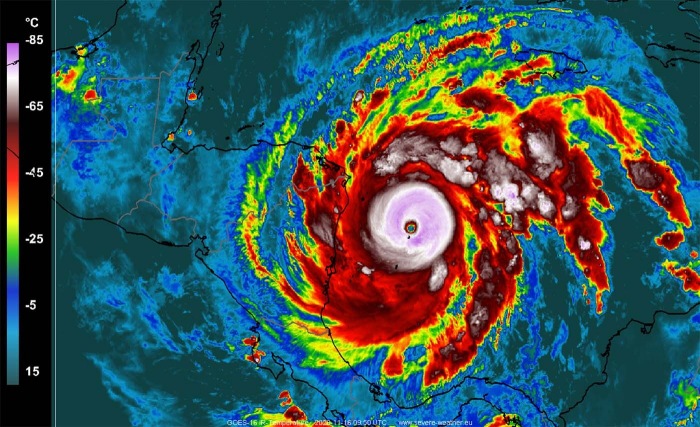
Although the Atlantic hurricane season 2020 has already generated record-breaking statistics – 30 named storms, 12 United States mainland landfalls, 9 Greek alphabet list storms, 6 major hurricanes, and record-breaking rapidly intensifying systems, the season is officially not finished yet. Two additional tropical waves are in focus. But does it mean there is also a threat for the United States?
The Atlantic 2020 hurricane season is absolutely going into the history books. There have been so many records broken, it was quite a challenge to follow all of those.
The official hurricane season for the Atlantic Basin (the Atlantic Ocean, the Caribbean Sea, and the Gulf of Mexico) runs from June 1st to November 30th. The peak of the season is from mid-August to late October.
At the beginning of the hurricane season, NOAA, TWC, and NCSU forecasters predicted: “There will be 13 to 22 named tropical storms in 2020, where 6-9 of those would reach hurricane strength, and 3-4 of them attaining major strength.” The official name list had 21 names reserved this year.
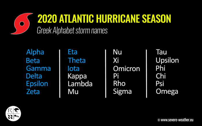
As of Sept 18th, the official list usage has been completed as all the reserved names were already used by that date. Since then, the Greek alphabet list is in use.
The 2020 Atlantic Hurricane Season officially ends at the end of November, but the most active years in the past have seen storms forming also in the off-season as well, even in December before.
And although the intensity of the 2020 hurricane season might not be as strong as the 2005 season or any other seasons in the past, we are still facing the fact, that this year has already generated 30 named storms. This is beyond any season on record.
The Atlantic, Caribbean region, the Gulf of Mexico, and the East Coast of the United States were also the most active tropical regions globally this year.
By looking over the average season percentile, the Atlantic hurricane season 2020 is indeed very remarkable! The image below is showing a comparison of the most active seasons, 2020 versus 2005. Graphics are provided by Sam Lillo.
A new study published in Nature found, that Tropical cyclones could last longer after landfall in a warming world. As a study noted: “Over the North Atlantic basin, storms are weakening more slowly as regional sea surface temperatures increase.”
This could mean that future hurricanes in the North Atlantic basin could be stronger after making landfall in the Caribbean region or the United States. Storms could also be more destructive farther inland after they make landfall.
“A long-term regional mean sea surface temperature over the Gulf of Mexico and the western Caribbean are warming up, which are adjacent to the land and supply the moisture for the storms before landfall.”
The Atlantic Ocean temperatures are increasing with the warming climate and could be the key factor behind the future trend for more dangerous hurricane landfall anywhere along the Gulf Coast, East Coast of the United States, and indeed across the tropical Western Atlantic, study says.
VERY WARM SEAS CONTRIBUTING TO RAPIDLY INTENSIFYING STORMS
The sea surface temperatures were very warm in the Western Atlantic this year, and even extremely warm (hot) over the Caribbean region with around 30-31 °C (87-89 °F) across the western portions of the Caribbean Sea at times.
The majority of the North Atlantic, tropical Atlantic, and the Caribbean was also well-above-average, about 1-2 °C warmer, even more across the Northwest Atlantic. And still is, even now, through the late November.
Waters also remain warm, much above the long-term average across the whole Gulf of Mexico, around Florida, the Bahamas, and along the East Coast of the United States. This just shows why hurricanes were so explosively developing over the last few weeks.
The 2020 Atlantic hurricane season has also the most number of storms undergoing 36-hour extremely rapid intensification of at least 75, 80, 85, and 90 knots in this period. For example, Hurricane Iota has intensified for 85 knots (100 mph) in 36 hours.
Only 8 storms have done this in 169 years of records prior to 2020, while in 2020 there were 3 storms doing the same – Delta, Eta, and Iota. All those storms are from the Greek Alphabet list, Delta was in October while Eta and Iota were in November.
The main contribution was a strongly developed Madden-Julian Oscillation (MJO) wave emerging into the tropical Atlantic. The MJO is the largest and most dominant source of short-term tropical variability, it is an eastward-moving wave of thunderstorms, clouds, rain, winds, and pressure. It circles the entire planet on the equator in about 30 to 60 days.
MJO wave is favorable for lowering the pressure and providing a strong boost to thunderstorm activity in the tropical Atlantic. If combined with extremely warm seas, the final result is then obvious.
HOW EXTREME ACTUALLY IS THE 2020 HURRICANE SEASON?
The 2020 Atlantic hurricane season is the most active season on record. There is no season in history that has seen more named storms than this year. Therefore, this year’s season is now grazing into uncharted territory. By both the number of named storms and their names.
There was been 30th named storms so far, 31 tropical depressions and there have already been 9 named storms using the Greek alphabet letters. Since the official list for 2020 Atlantic hurricane season had 21 names reserved. Those were completed on Sept 18th.
The busiest month of the season was September 2020, which is typical as the peak of the season is Sept 10th. There were 10 named storms, which set a new record. The years 2002, 2007, and 2010 had the highest, 8 named storms formed in September until this year.
These are the storm tracks for the 2020 Hurricane season so far. The image is provided by Wikipedia, data plots are based on the official data from the National Hurricane Center.
And the 2020 hurricane season indeed remains on course for an even more exceptionally record-setting year to date, Nov 19th. The season officially ends on Nov 30th.
There seems to be a fairly high chance that the well-above-average western Atlantic and Caribbean region sea temperatures would be favorable for tropical storm formation even in December this year.
If a few more storms form this year, we are definitely aiming towards Nu or Xi storm names. So that would be halfway through the Greek Alphabet names.
30 named storms so far mean that this is about 259 % of the long-term average (11.6) as of Nov 19th. So far, there were more than double the number of hurricanes (13) and five (6) major hurricanes (Laura, Teddy, Delta, Zeta, Eta, and Iota).
An impressive record is also that 28 storms out of those 30 total, had the earliest formation date on record.
As of Nov 16th, there have been 117 named storm days so far, which is around 208 % of the average number (56.3). As we can see from the statistical graphics above (see the column 2nd from the right), all the forecast parameters are greatly much above average. Including hurricane days (34), major hurricanes (6), and major hurricane days (8.5). Provided graphics are by dr. Philip Klotzbach.
With a still high potential for a few more tropical (or subtropical) depressions or storms forming through November, we might be reaching halfway through the Greek Alphabet names. The potential remains high that additional storms could form in the next two weeks (see further down).
12 TROPICAL SYSTEM LANDFALLS IN THE UNITED STATES MAINLAND IN 2020
The last system to make landfall in the United States was Tropical Storm Eta on Nov 8th. Eta made landfall in the Florida Keys.
Eta made a rare November landfall in Florida, the first in the last 22 years (the last system to make landfall in Florida was Mitch in November 1998). While the most recent November hurricane landfall in Florida was Hurricane Kate in 1985. Kate hit Mexico Beach, Florida on November 21st, 1985.
The 2020 Atlantic hurricane season has come to the unprecedented record-breaking 12 landfalls of tropical storms (or hurricanes) in the United States mainland. This has never happened before, and the 2020 hurricane season broke the previous record of 9 landfalls set in 1916. More than 100 years old record!
The twelve (12) named storms that made landfall in the continental United States this year (2020) so far are Bertha, Cristobal, Fay, Hanna, Isaias, Laura, Marco, Sally, Beta, Delta, Zeta, and Eta.
And to make it even greater, there were six (6) hurricane landfalls out of those 12 named storm landfalls in the United States mainland this year. This ties with the 6 hurricane landfalls in one full season (1985 and 1886).
MAJOR HURRICANES OF 2020 ATLANTIC SEASON
Major hurricanes Laura, Teddy, and Delta have all peaked at Category 4 strength. Laura and Delta both made destructive landfalls in Louisiana. Delta’s center came ashore on October 9th and, interestingly, the landfall was just about 15 miles east of the landfall point of Hurricane Laura, which struck at the end of August.
Laura’s landfall was a borderline Category 5 in Louisiana – the strongest since 1856.
The southern parts of Louisiana along the central Gulf Coast of the United States, were a hot spot this year. There have been 5 storms that made landfall in Louisiana. Three (3) of those five were hurricane landfalls (Laura, Delta, and Zeta).
Laura made landfall as a Category 4, while Delta and Zeta were a Category 2 when they came ashore in Louisiana. Laura and Delta affected the same areas with severe wind and storm surge damage. Zeta made landfall further east, due south of New Orleans.
IOTA – FIRST CATEGORY 5 HURRICANE OF 2020 SEASON
The last system was Hurricane Iota, the 30th named storm of the Atlantic 2020 hurricane season. Setting the record level even higher after Subtropical storm Theta set a new record of 29 named storms in one season, the previous record was 28 named storms set in 2005.
Iota was also the 9th named storm from the Greek Alphabet list and also the 31st tropical depression forming in 2020. And this is the first time on record that any Atlantic hurricane season would go this deep into the Greek alphabet list for named storms.
During its peak intensity, Iota was a major Category 5 hurricane, the latest Atlantic calendar year Category 5 hurricane on record. The previous record was November 8th by the Cuba Hurricane (1932).
As major hurricane Iota formed in November (remember, there was another major Hurricane Eta in early November), This set another remarkable record for the 2020 Atlantic hurricane season: There are no seasons on record that have had two major hurricane formations in the month of November!
And to top these statistics, Iota was also the 6th major hurricane of the 2020 hurricane season and the first Greek alphabet Atlantic named storm to reach Category 5 intensity on record.
A specific metric is used to express the energy used by a tropical cyclone during its lifetime, it is called The Accumulated Cyclone Energy. The energy of each tropical system during the hurricane season is calculated as an index – the ACE index.
What exactly is the Accumulated Cyclone Energy (ACE index)?
The index calculation takes the cyclone’s maximum sustained winds every six hours and multiplies it by itself to generate the values. The total sum of these values is calculated to get the total for a storm.
The current Atlantic basin ACE is, as of November 19th, already at 180. That is an impressive 76 percent higher than during a normal season to this date (102.3).
The highest ACE so far this season was generated by Teddy (27.8), Eta (18.1), Paulette (15.9), Delta (15.7), Epsilon (13.1), and Laura (12.8). The last system – hurricane Iota – added another 12.7 to the ACE index total for the Atlantic 2020 hurricane season.
At the beginning of November 2020, the Accumulated Cyclone Energy (ACE) index was already past the definition of an ‘extremely active’ season, with the threshold of 152.5 ACE. In other words, this means that the 2020 Atlantic hurricane season is now officially an extremely active season.
However, there is still a long run to reach the strongest Atlantic hurricane seasons in recorded history. Those years were: 1933 (ACE of 258.6), 2005 (250.1), or 1893 (231.2).
TROPICAL WAVE TO BRING FLOODING INTO CENTRAL AMERICA
There is now additional tropical activity possible, actually two areas of interest. One is over Central America and another one is near Bermuda. Both areas are being watched for potential tropical or subtropical development.
Attached below is the pressure forecast for early next week, where we can see both low-pressure systems, marked with ‘L’. Image is provided by Windy.com.
The first area is another tropical wave that is slowly moving west across the southwestern portions of the Caribbean Sea. It is moving towards the southern parts of Central America.
Showers and thunderstorms have diminished since yesterday in association with a broad area of low pressure located over the far southwestern Caribbean Sea just off the northern coast of Panama. Development of this system is not expected while it moves little over the southwestern Caribbean Sea during the next several days.
This system is expected to produce locally heavy rains and possible flooding over portions of southern Nicaragua, Costa Rica, Panama, and northern Colombia during the next few days. Models are forecasting a concerning amount of rainfall will be possible, potentially even close to 500 mm over Costa Rica.
The National Hurricane Center (NHC) is giving this wave a 0 percent (0 %) chance to become a tropical depression in the coming days.
SUBTROPICAL WAVE POSSIBLE NEAR BERMUDA
The second area of interest is a rising potential for a new storm formation near Bermuda. NHC has been watching the model trends over the past two days that are hinting at an increasing potential for a subtropical storm to develop.
A non-tropical area of low pressure could form between the Bahamas and Bermuda by early next week. The system could gradually develop subtropical characteristics through the middle of next week while it moves northeastward over the western Atlantic.
Although Bermuda might not be in the direct part of the potential new system, there is a lot of rain seen on the models. The majority of the precipitation, however, remains east-southeast of the island.
Huge amounts of the system’s rainfall could lead to life-threatening flash floods and mudslides from the mountainous terrain down into the lower parts of Coastal Rica, Panama, and northern Colombia.
The National Hurricane Center (NHC) is giving this wave a 20 percent (20 %) chance to become a subtropical storm over the next 5 days.
Givevn the overall steering winds by the ongoing pattern across the North Atlantic and the United States, this system doesn’t seem to be turning towards the United States at this time.
But conditions and trends need to be monitored for the following weeks as conditions with very warm seas remain.
COULD KAPPA AND LAMBDA FORM?
The next two named storms from the Greek alphabet list would be Kappa and Lamda.
The 2020 Atlantic hurricane season has so far used 9 letters from the Greek alphabet, the highest ever. Pushed the total number of storms to 30. The last storms were major hurricanes Eta and Iota, and subtropical storm Theta near the Azores. All three formed in the month of November.
If these storms indeed occur, they would be the 10th and 11th letters from the Greek alphabet list. And push the total count of the season to 32 named storms. An uncharted territory where no season has even been in the recorded history in tropical systems in the Atlantic basin.
Don’t miss a chance for a nice gift for your friends, family or someone special… Weather calendar could be the perfect gift for them – see below:


