The Atlantic Hurricane Season 2021 enters its second half, typically the most active period when the majority of the tropical cyclones form in the Atlantic Basin. Larry is the 12th named storm, coming soon after a devastating hurricane Ida on Sunday, Aug 29th, and tropical storms Kate and Julian. It is expected to become a violent monster with likely at least a Category 4 strength over the weekend.
As soon as we entered into the second half of the Atlantic hurricane season, a Tropical Depression 12 (TD12) formed with the major thunderstorm complex ejecting from Western Africa. A day after, TD12 was upgraded into a Tropical Storm Larry on Wednesday, intensifying into a hurricane by Thursday morning.
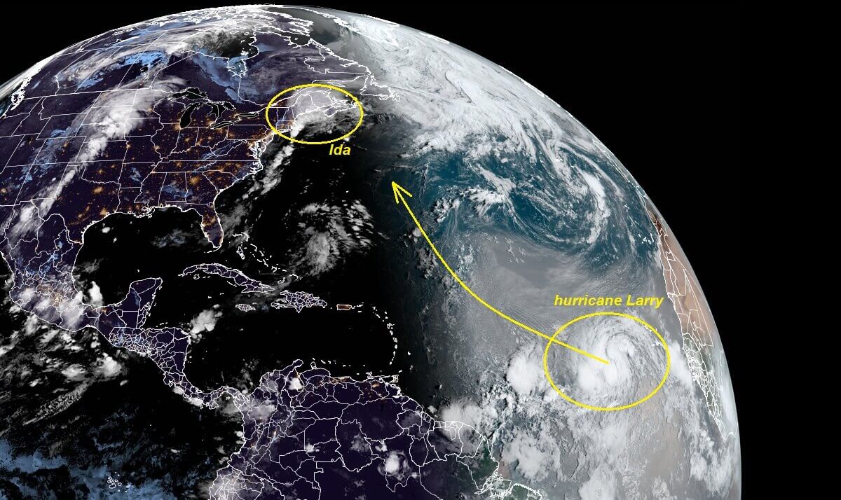
Larry was about 550 miles from the southernmost point of the Cape Verde Islands on Thursday, off the west coast of Africa. Moving westward at about 20 17 knots with maximum sustained winds of 75 mph, according to the National Hurricane Center (NHC).
Soon as Larry reached above 64 mph, it became the 5th hurricane of the 2021 Atlantic season. Note that only 6 seasons have had 5 hurricane formations by Sept 2nd over the last 55 years. Larry is forecast to turn into a violent Category 4 storm by Sunday or Monday. Quite an explosive thunderstorm activity is seen with the strengthening system.
For now, Larry is expected to track west-northwest and unlikely to reach any land areas anytime soon, but we still have a lot of uncertainties regarding its future track in the next 5-7 days. Next week, it may approach Bermuda or even make its turn towards North America (United States).
At the same time, the global weather model ECMWF is also forecasting a very strong trade wind surge in the central Pacific through mid-August. In other words, this means that these anomalously strong low-level winds typically favor a transition to La Nina for the latter part of the Atlantic hurricane season.
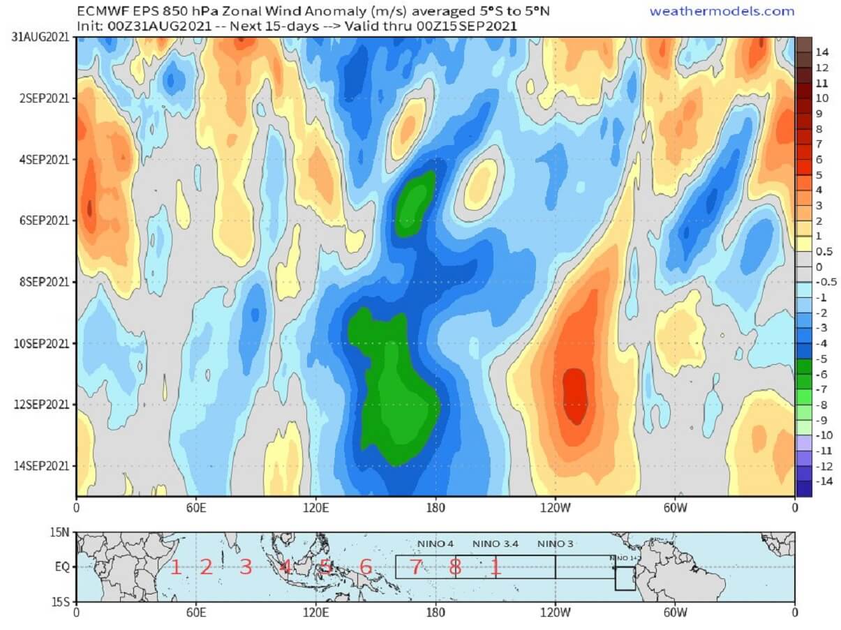
This could mean a very busy period with tropical activity in the following weeks.
ATLANTIC HURRICANE SEASON GOES INTO 2ND HALF
Larry is the 12th name on the tropical cyclone list for 2021, forming on September 1st, and is the only hurricane season on record with 7 named storm formations between August 10th and Sept 1st, tied with 2011. Larry is also among the only 6 other seasons that had 12+ named storms by September 1st – those were 1995, 1996, 2005, 2008, 2012, 2020. We can remember 2005 and 2020, the two most active Atlantic hurricane seasons on record.

The Atlantic hurricane season 2021 has, besides having a much above-average number of storms, also generated the most Accumulated Cyclone Energy (ACE) through August 30 since 2008. 45.2 of ACE was accumulated by Sept 1st. Note that ACE is an integrated metric accounting for the frequency, intensity, and duration of storms.
The monitoring of tropical activity uses the ACE index to express the energy that was used during the tropical cyclone’s lifetime. This is how we can then compare every tropical storm or hurricane with the other. The ACE index is an abbreviation for the Accumulated Cyclone Energy, or short: ACE which is used for all the tropical regions around the world. For the Atlantic Hurricane Season the NOAA forecasters use 4 categories to classify storms by the ACE index:
- Extremely active – ACE index above 152.5
- Above-average – ACE index above 111
- Near-average – ACE index between 66 and 111
- Below-normal – ACE index below 66

The chart above indicates the Atlantic hurricane season statistics for the recent 15 years, including the final ACE value and also the number of hurricane formations.
So far, the highest ACE this Atlantic hurricane season was generated by major hurricane Ida – 10.82 ACE, then Hurricane Elsa – 9.52 ACE, and 7.72 ACE by Hurricane Henri. Also, the developing hurricane Larry has already generated 1.57 ACE by Sept 2nd. Larry is expected to generate the highest Accumulated Cyclone Energy for the season so far, as it will be an intense and long-lasting tropical cyclone.
ATLANTIC BASIN WATERS REMAIN VERY WARM
The Atlantic sea surface temperatures are anomalously warm this year, especially since the beginning of August, and continue also into the 4th month of the hurricane season 2021. Those are the warmest across the Caribbean, the Gulf of Mexico, and the rest of the Atlantic Ocean as well.
The sea surface temperatures (SSTs) are ranging from 28 to nearly 30 °C across the tropical Atlantic, up to 32 °C in the Gulf of Mexico. The east-central Atlantic, where hurricane Larry formed, has a water temperature of around 28 °C. And Larry is moving into even warmer sea waters farther west over the weekend. This normally means good support for additional strengthening.

As we can see, water surface temperatures of 30-32 °C are observed over much of the Gulf of Mexico. This is a very concerning and significant signal for the upcoming tropical storms that will form in the coming weeks as the peak of the Atlantic hurricane season nears. Normally, the explosive development of tropical storms is often observed when they encounter very warm and moist fuel at the sea surface.
The SSTs have also anomalously warmed across a so-called MDR region (Main Development Region), a virtual region extending between the west coast of Africa and the Caribbean Sea.

These high-temperature anomalies hint at the strongly enhanced potential for significant tropical cyclone development. As those will remain in place or even improve in the coming weeks and months, for the period around the peak of the Atlantic hurricane season, any system forming has to be closely monitored.
We could see hurricane Elsa and Ida how they literally exploded in the Gulf of Mexico recently. And we could already see how hurricane Larry is strengthening these days, and further rapid intensification will follow.
HURRICANE LARRY STRENGTHENING TOWARDS THE CENTRAL ATLANTIC
A deep tropical wave ejected off the West coast of Africa on Monday and soon began gradually strengthening, becoming a seasonal 5th hurricane on Wednesday night. The satellite analysis is hinting that Larry is in a very healthy environment for additional strengthening.
The Advanced Dvorak Technique (ADT) analysis estimated indicates that there are hurricane-force 64-knot winds spread across 20-30 miles radii around the developing eye. The tropical storm winds of 50 knots are extending 40-60 miles around the center.

As we can see from the right chart of the image above, the rate of intensification has become steeper on Wednesday as Larry has entered better oceanic conditions. This Thursday, the Dvorak analysis is estimating the central pressure of around 980 mbar and sustained winds of 75-80 knots.

As seen by the satellite analysis, Larry’s cloud pattern has gradually become better organized Wednesday night into Thursday, with deep convection increasing in coverage and intensity near the center. A banding-type eye is trying to form with visible upper-level outflow ventilation over the western and northern portions of the circulation.
The hurricane is moving about due west, roughly 280 degrees with 17 knots of forwarding speed. Larry is forecast to move along the southern periphery of a strong deep-layer subtropical high-pressure area (Azores High) over the east-central Atlantic during the next few days. This should result in a gradual turn toward the west-northwest by Sunday.

Hurricane Larry is expected to remain in very favorable oceanic and environmental conditions conducive for further strengthening over the next few days, with warm Atlantic waters, low vertical wind shear, and surrounded by the broad-scale anticyclonic upper-level flow.

This calls for strengthening support, and it is expected Larry to become a major hurricane (Category 3) in about 48 hours, that is on Saturday or Sunday at max.
After Sunday through Monday, Larry could intensify into a Category 4, potentially becoming the second hurricane of this strength after Major hurricane Ida last week.

The global weather models hint at a very violent wind field developing as Larry enters a major hurricane strength after Sunday, potentially up to a solid/high-end Category 4 strength. With nearly 130-140 mph of sustained winds, gusting above 160 mph. It may even become a Category 5 by some of the model simulations.
***The images used in this article were provided by NOAA, and Windy.