The intensifying hurricane Florence is a Category 2 hurricane now, with sustained winds of 105 mph and central pressure of 969 mbar. Based on the latest satellite presentation, additional rapid strengthening is expected through the next 24-36 hours as near-ideal conditions are present ahead of Florence’s path – almost no wind shear and extremely warm sea surface. The hurricane’s shape is becoming symmetrical and the eyewall is becoming stronger with a distinct eye visible. We can expect Category 4 strength by tomorrow morning, Tuesday Sept 11th.
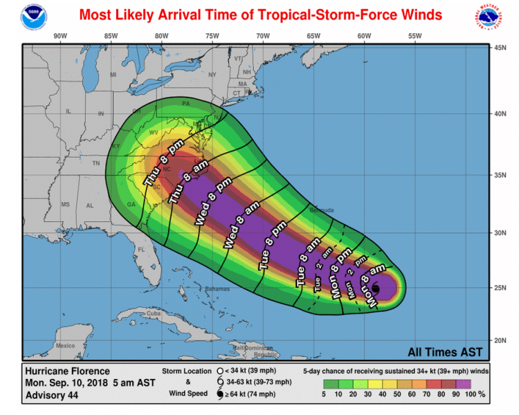
This is the official NHC forecast path of hurricane Florence: it is becoming increasingly likely that landfall will occur into the Carolinas, where Florence will hit as a major hurricane of at least a Category 3 strength. Arrival time of landfall in Carolinas is estimated to be Thursday morning.
Different model guidance for Florence intensify before making landfall suggests it will reach a Category 4 strength by tomorrow and could make a landfall as a Category 3 or 4 on Thursday (84-96 hours from now). Overall, a very powerful storm will develop and go through a rapid strengthening in the next two days.
Here are various model tracks for hurricane Florence path through the next 5 days – mostly all agree that the likely impact/landfall will be North Carolina, while some tracks also suggest that landfall would be in South Carolina. A lot depends on the evolution through the next 72 hours as a strong ridge remains positioned across the NE United States and pushes Florence due west. This is quite a rare occurence, and this hurricane could become rather rare devastating for Carolinas at some point.
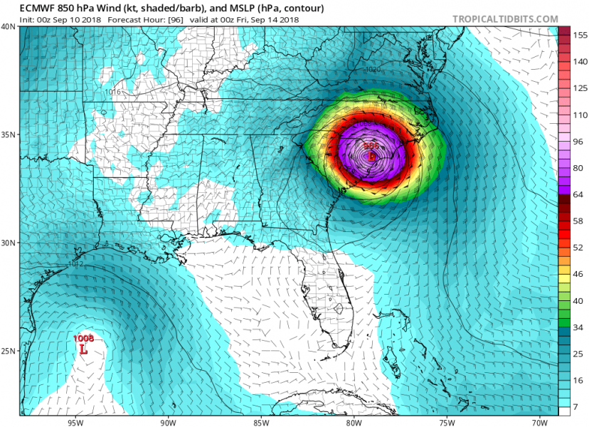
Comparison of GFS and ECMWF model below, one is trending into north while the other one is trending towards the landfall in northeast South Carolina. Both are today’s model runs.
Here is the latest NHC (National Hurricane Center) forecast discussion about Florence:
Hurricane Florence Discussion Number 44…CORRECTED
NWS National Hurricane Center Miami FL AL062018
500 AM AST Mon Sep 10 2018
Florence is rapidly strengthening this morning. The satellite presentation has improved markedly overnight with a small 10-n-mi wide-eye becoming apparent in infrared satellite pictures. The
upper-level outflow continues to expand over the northern and northwestern portions of the storm, but is somewhat restricted over the southeastern quadrant. Dvorak satellite classifications from TAFB and SAB supported an intensity of around 80 kt at 0600 UTC, but with the cooling of the cloud tops around the eye since that time, the initial intensity has been increased to 90 kt for this advisory.
Satellite fixes indicate that Florence has turned west-northwestward (285 degrees), and is moving at a slightly faster forward speed of 8 kt. A high pressure ridge building to the north and northwest of Florence is expected to steer the hurricane west-northwestward to northwestward at a much faster forward speed over the southwest Atlantic during the next few days. After that time, a building ridge over the Ohio Valley is expected to cause a gradual reduction in the forward speed of the cyclone as it approaches the southeastern United States coastline. The latest run of the ECMWF has shifted southwestward, along with its ensemble suite, while there was little overall change in the GFS and its ensemble. On the other hand, the UKMET shifted northeastward and is now along the right side of the guidance envelope. With these changes to the guidance, the overall spread has increased this cycle, however, the corrected consensus aids (FSSE and HCCA) are not much different than before, and the NHC track again follows these models very closely. Users are cautioned to not focus on the exact forecast track as the average NHC errors at days 4 and 5 are about 140 and 180 n mi, respectively.
Florence will be traversing very warm SSTs of around 29C and remain within a very favorable upper-level environment during the next couple of days. These conditions are expected to lead to
significant strengthening during the next 12 to 24 hours, and Florence is forecast to be a very powerful major hurricane on its approach to the southeastern United States. The NHC intensity
forecast is slightly above all of the intensity guidance during the first 24 hours, and is then a blend of the FSSE and HCCA models. The global model guidance also increases the size of Florence’s wind field during the next few days, and this has been reflected in the NHC wind radii forecast.
The NOAA G-IV jet is conducting another synoptic surveillance mission this morning in support of the 1200 UTC model cycle, and these flights will continue through Tuesday. A NOAA P-3 Hurricane
Hunter aircraft is also scheduled to conduct a research mission into Florence this morning, with Air Force C-130 fix missions beginning late this afternoon. Additional upper-air data are being collected across portions of the central and eastern U.S. via special 0600 UTC and 1800 UTC radiosonde launches. Hopefully these data will help improve the track and intensity forecasts.
Key Messages:
1. There is an increasing risk of life-threatening impacts from Florence: storm surge at the coast, freshwater flooding from a prolonged and exceptionally heavy rainfall event inland, and
damaging hurricane-force winds. While it is too soon to determine the exact timing, location, and magnitude of these impacts, interests at the coast and inland from South Carolina into the mid-Atlantic region should closely monitor the progress of Florence, ensure they have their hurricane plan in place, and follow any advice given by local officials.
2. Large swells affecting Bermuda and portions of the U.S. East Coast will continue this week. These swells will result in life-threatening surf and rip currents.
FORECAST POSITIONS AND MAX WINDS
INIT 10/0900Z 24.9N 58.9W 90 KT 105 MPH
12H 10/1800Z 25.4N 60.5W 110 KT 125 MPH
24H 11/0600Z 26.1N 63.1W 120 KT 140 MPH
36H 11/1800Z 27.3N 66.2W 125 KT 145 MPH
48H 12/0600Z 28.8N 69.3W 130 KT 150 MPH
72H 13/0600Z 32.2N 74.8W 125 KT 145 MPH
96H 14/0600Z 34.5N 78.1W 100 KT 115 MPH…INLAND
120H 15/0600Z 35.8N 79.6W 40 KT 45 MPH…INLAND
Forecaster Brown
Stay tuned for further updates in the coming days!


