NASA Detects a Major Pacific Sea Level Rise as Super El Niño Rapidly Strengthens
UPDATE June 26th, 2026: Super El Niño Is Now Breaking Into the Atmosphere as July Forecasts Show a Pattern Shift for the U.S. and Canada …
All the latest news and forecast articles are found below the intro in chronological order.
ENSO is short for “El Niño Southern Oscillation”. This is an oceanic temperature anomaly that changes between warm and cold phases across the equatorial Pacific Ocean. Typically, there is a phase change roughly about every 1-3 years.
ENSO significantly influences tropical rainfall patterns (storms) and impacts the complex relationship between the ocean and the atmosphere. We usually observe large-scale pressure changes in the tropics with each new developing phase. After some delay, these changes affect the circulation over the rest of the world.
The image below shows the ENSO regions in the tropical Pacific. Regions 3 and 4 cover the east and west and together cover a large part of the tropical Pacific. Most analyses and forecasts are focused on a combination of regions 3 and 4, seen in the image as the main Nino 3.4 region.

Each ENSO phase has a different effect on the pressure and weather in the tropics. This translates to the overall global weather circulation with time, changing the weather patterns worldwide.
A specific phase (cold/warm) usually develops between late summer and early fall and typically lasts until next summer. But some events can last even up to two full years.
The cold ENSO phase is called La Nina, and the warm phase is called El Nino. The name La Nina translates to “the girl”, and the name El Nino translates to “the boy”, indicating an opposite dynamic between the two oceanic phases.
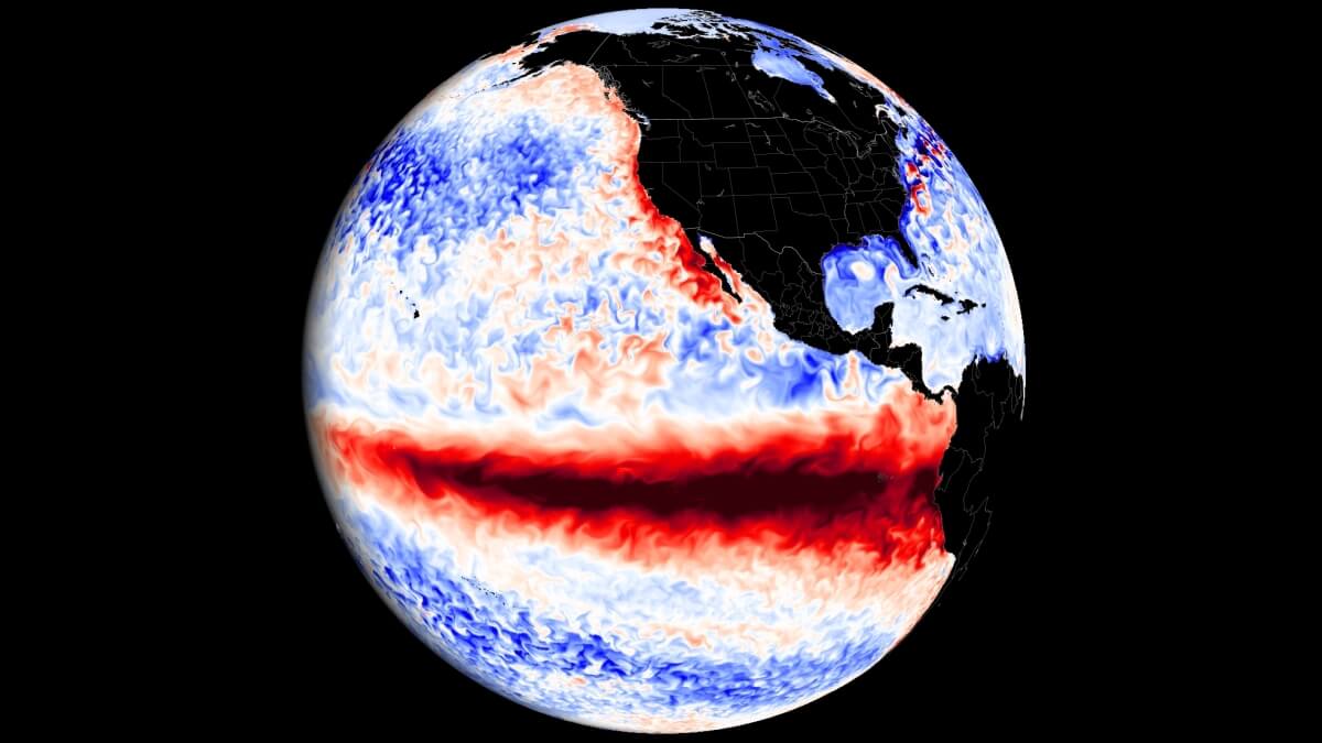
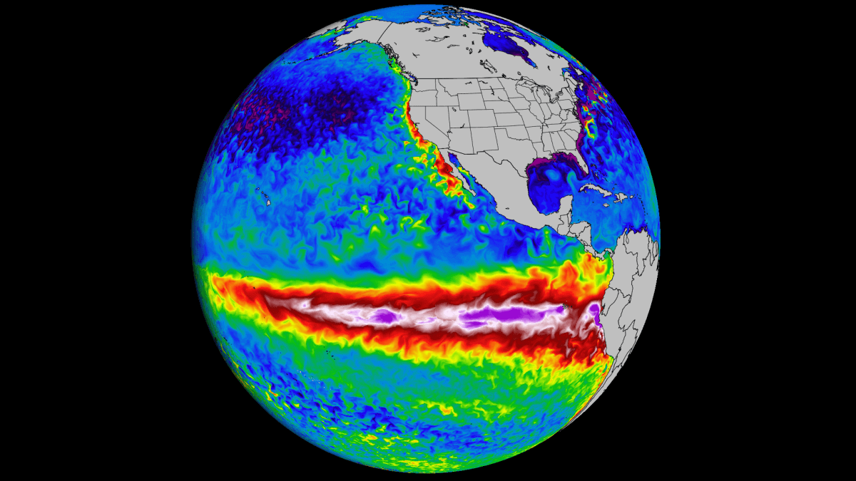
The ENSO phases are determined by looking at the sea surface temperature anomalies (warmer/colder) in the ENSO 3.4 region, which was presented in the previous image.
In the image below, we have a direct comparison between the ocean temperature anomalies during a warm (El Nino) and a cold event (La Nina). Both examples show realistic data from the ten strongest events for each phase.

Typically, an El Nino develops stronger anomalies, which are focused more on the central and eastern regions.
But while La Nina has weaker peak anomalies than the El Nino, it typically peaks more from the central to the western region.
The image below from NOAA Climate shows the typical circulation during a cold ENSO phase (La Nina) that we are experiencing for the past two seasons. Air descends in the eastern Pacific, causing stable and dry weather, while air rises in the western Pacific, causing frequent thunderstorms and a lot of rainfall.

This way, ENSO has a major impact on the tropical rainfall and pressure patterns and impacts the ocean-atmosphere feedback system. Through this ocean-atmosphere system, the ENSO influence is distributed globally.
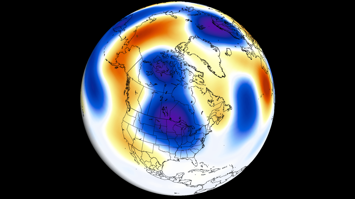
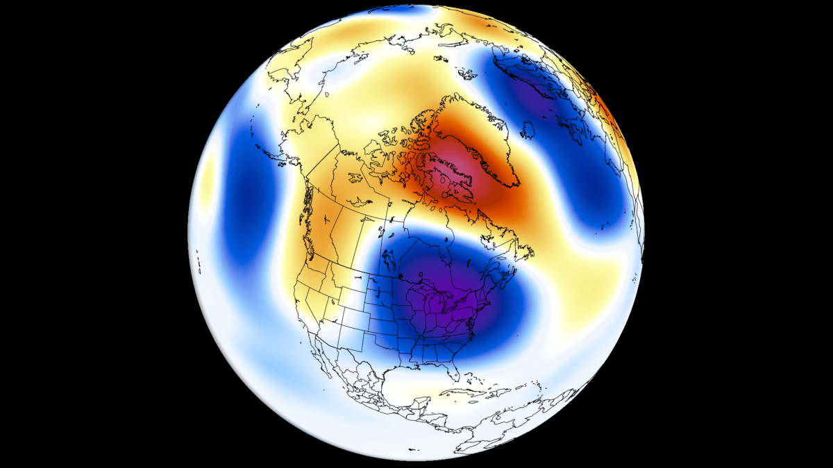
We usually observe a global shift in pressure patterns during the emergence and duration of the ENSO phases.
But why and how does ENSO shift between cold and warm phases?
There is no simple answer, but we can say that it results from the complex dynamics between pressure patterns and winds in tropical regions. The trade winds usually start or stop a certain phase by mixing the ocean surface layers and changing the ocean surface currents.
What are the trade winds? The trade winds are steady and persistent winds, blowing towards (and along) the Equator in both Hemispheres. The image below shows a simplified map of the global prevailing winds, with tropical trade winds marked yellow and red.

Below is a map that also shows the prevailing near-surface winds, but based on the actual data from the past four decades. We can nicely observe the easterly trade winds in the Atlantic Ocean and in the Pacific Ocean, which also help to drive the warming and cooling across the ENSO regions.

When these easterly winds get stronger, they start changing the ocean surface currents, and they start pushing the water from east to west. This moves warm surface waters towards the west, bringing deeper (colder) waters closer to the surface to replace it.
With this mechanism, the ocean surface temperatures start to change across the ENSO regions. The trade winds can initiate a new phase or boost the active one depending on their strength.
UPDATE June 26th, 2026: Super El Niño Is Now Breaking Into the Atmosphere as July Forecasts Show a Pattern Shift for the U.S. and Canada …
UPDATE June 11th, 2026: NASA Detects a Major Pacific Sea Level Rise as Super El Niño Rapidly Strengthens, with Atmospheric Impacts Already Visible The transition …
The transition into Summer 2026 is being defined by rapid, significant changes in the oceans and the atmosphere. Latest oceanic analysis and forecast data confirms …
LATEST UPDATE – May 7th, 2026: We produced a new update article with the latest forecast and analysis data: Atmospheric Code Red: 2026 Super El …
May 1st, 2026 UPDATE: New seasonal model data reveals a stronger El Niño signature than previously expected. This also means an atmospheric impact already visible …
UPDATE – March 12th 2026: A global weather shift is underway as La Niña has officially collapsed. New ocean data reveals a massive Kelvin wave …

La Niña has begun to break down rapidly across the tropical Pacific Ocean. Cold anomalies are now weakening from the west, but the atmospheric influence …

Latest forecast data shows an El Niño to return in 2026, strengthening in the second half of the year and lasting through the 2026/2027 season. …