Skip to content

Severe Weather Europe

Global Weather News and Forecasts, covering the United States, Canada and Europe

  • HOME
  • WEATHER ANALYSIS
    • RECENT EVENTS
    • LATEST NEWS
    • Satellite Live
    • Radar Live
    • Lightning Live
    • EVENT ANALYSIS
    • Notable Events
  • WEATHER FORECAST
    • SWE weather models
    • SEVERE WEATHER FORECAST
      • Severe Weather Outlooks FAQ
    • SEVERE WEATHER OUTLOOK ARCHIVE
    • GLOBAL WEATHER
    • LONG RANGE
    • WINTER WEATHER
    • Europe Weather
    • TROPICAL WEATHER
    • MESOSCALE DISCUSSION
  • POLAR VORTEX
  • LEARN WEATHER
  • ABOUT & CONTACT
    • ABOUT US
    • Privacy Policy
    • CONTACT US

drifts

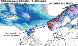
Excessive snowfall in SW Norway, locally more than 100 cm until Tuesday Nov 14th
November 9, 2017November 9, 2017 by Marko Korosec

Impressive amounts of fresh snow are expected across the higher terrain of SW Norway through the next 4 days, until Tuesday Nov 14th. The current … Read more

Categories Mesoscale Discussion Archives Tags arctic, cold, drifts, europe, norway, scandinavia, snow, trough, wind
Live radar, satellite and lightning maps SWE weather models Learn Weather

Recent Posts

  • New Snowfall Forecast for Winter 2026/2027: More Snow and a First Look at Christmas
  • Intense Zonal Flow Pattern Targets Europe: Rapid Atlantic Storms Bring Heavy Rainfall and Strong Winds
  • Polar Vortex Reversal: Stratospheric Impact Wave Could Arrive by Thanksgiving
RSS Feed
© 2026 Severe Weather Europe • About • Contact • Privacy Policy