Skip to content

Severe Weather Europe

Global Weather News and Forecasts, covering the United States, Canada and Europe

  • HOME
  • WEATHER ANALYSIS
    • RECENT EVENTS
    • LATEST NEWS
    • Satellite Live
    • Radar Live
    • Lightning Live
    • EVENT ANALYSIS
    • Notable Events
  • WEATHER FORECAST
    • SWE weather models
    • SEVERE WEATHER FORECAST
      • Severe Weather Outlooks FAQ
    • SEVERE WEATHER OUTLOOK ARCHIVE
    • GLOBAL WEATHER
    • LONG RANGE
    • WINTER WEATHER
    • Europe Weather
    • TROPICAL WEATHER
    • MESOSCALE DISCUSSION
  • POLAR VORTEX
  • LEARN WEATHER
  • ABOUT & CONTACT
    • ABOUT US
    • Privacy Policy
    • CONTACT US

cumulus

Updraft characteristics and thunderstorm strength

July 31, 2025 by Marko Korosec
updraft appearance explosive

The visual appearance of the updraft can tell a lot about its strength and potential to produce a strong thunderstorm. As the updraft rises through … Read more
Categories Severe Weather Theory Tags cumulonimbus, cumulus, thunderstorm, updraft

Types of convective clouds – from fair-weather clouds to thunderstorms

February 21, 2025 by Marko Korosec
convective-cloud-types

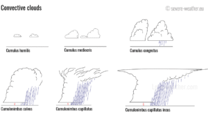
Convection forms distinct types of clouds. Convective clouds are divided into two types (genera): cumulus and cumulonimbus. Each successive kind and species displays more vertical … Read more

Categories Severe Weather Theory Tags calvus, capillatus, clouds, congestus, convection, convective cloud types, convective clouds, cumulonimbus, cumulus, humilis, mediocris, thunderstorm
Live radar, satellite and lightning maps SWE weather models Learn Weather

Recent Posts

  • Polar Vortex Split Forecast: The Earliest Stratospheric Warming on Record Is Coming
  • Winter 2026/2027 Snowfall Forecast: How October Data Changed Your Region’s Outlook
  • Can October Snow Predict Your Winter? I Tested a Famous Forecast Signal Across 47 Winters
RSS Feed
© 2026 Severe Weather Europe • Built with GeneratePress