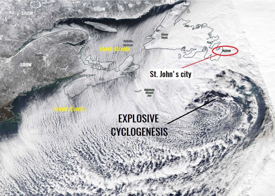
A spectacular satellite presentation of an explosive cyclone over the Northwest Atlantic on Friday, Jan 17th, has brought a massive, record-breaking snowstorm into Newfoundland (Canada) especially across its far east-southeast parts. The airport of St. John’s has received 30 inches (76.2 cm) of snow in 24 hours. With the daily total of 76.2 cm on January 17, 2020, a new all-time record has been established for the most snow in one day at St. John’s International Airport. Winds hit speeds of more than 60 mph (= 100 km/h). Some areas experienced an intense blizzard conditions with wind gusts in excess of 100 mph ( = 160 km/h)!
Satellite image of the explosive cyclogenesis over the Northwest Atlantic on Friday – notice an impressive convective cloud streets in the cyclone’s wake, as Arctic air mass was spreading from Canada onto the Atlantic. The city of St. John’s is marked:
North Atlantic today – a small but very photogenic cyclone delivers a spectacular satellite show
Reports of incredible snowdrifts and numerous road closed and blocks are coming, here are the most impressive ones – snowdrifts were several meters high, trapping residents in houses and on the roads:
If you’ve been hearing about the snow in Newfoundland but can’t quite picture it, this is a real time-lapse taken yesterday. pic.twitter.com/TRsBhg9fhd
— Yoni (@OriginalYoni) January 19, 2020
https://twitter.com/GrayMarker99/status/1218542915527553025
https://www.facebook.com/watch/?v=471117467157782
https://twitter.com/bobhallett/status/1218508660474818560
This timelapse best depicts the snowfall that parts of Eastern Newfoundland experienced yesterday. Unfathomable. pic.twitter.com/i1CmqbIAzr
— Yoni (@OriginalYoni) January 19, 2020
https://twitter.com/KellyCanuckTO/status/1218910366421397505
https://twitter.com/deirdreryan/status/1219294458564546560
This is Elizabeth avenue by MUN. Even a full sized truck couldn’t make it through yesterday and is just abandoned in the middle of the road #nlwx pic.twitter.com/dEGPtI7GFH
— Peter Cowan (@PeterCBC) January 18, 2020
Cars are slowly emerging from under the snow. People in the neighbourhood stopping by to help people who are buried. #nlwx #NewfoundlandStorm pic.twitter.com/pEgM2YKkn5
— Peter Cowan (@PeterCBC) January 19, 2020
Here’s what it looked like on the ground as the cars started to emerge from their snow cocoon #nlwx #blizzard2020 pic.twitter.com/AwJimXYS6r
— Peter Cowan (@PeterCBC) January 19, 2020
ICYMI: Residents wake up to snowed-in homes and a rare state of emergency after a blizzard blanketed Newfoundland, Canada pic.twitter.com/6oyeAThSDZ
— Bloomberg Originals (@bbgoriginals) January 20, 2020
https://twitter.com/jgquinton/status/1218571330280288257
An archaeological dig in Canada.#MeanwhileInCanada #snowstorm pic.twitter.com/TwphqhQAnW
— Meanwhile in Canada (@MeanwhileinCana) January 19, 2020
See also – the discussion about the system which was an explosive cyclogenesis over the Northwest Atlantic:
North Atlantic today – a small but very photogenic cyclone delivers a spectacular satellite show
An impressive twins over the North Pacific today, Jan 20th:
