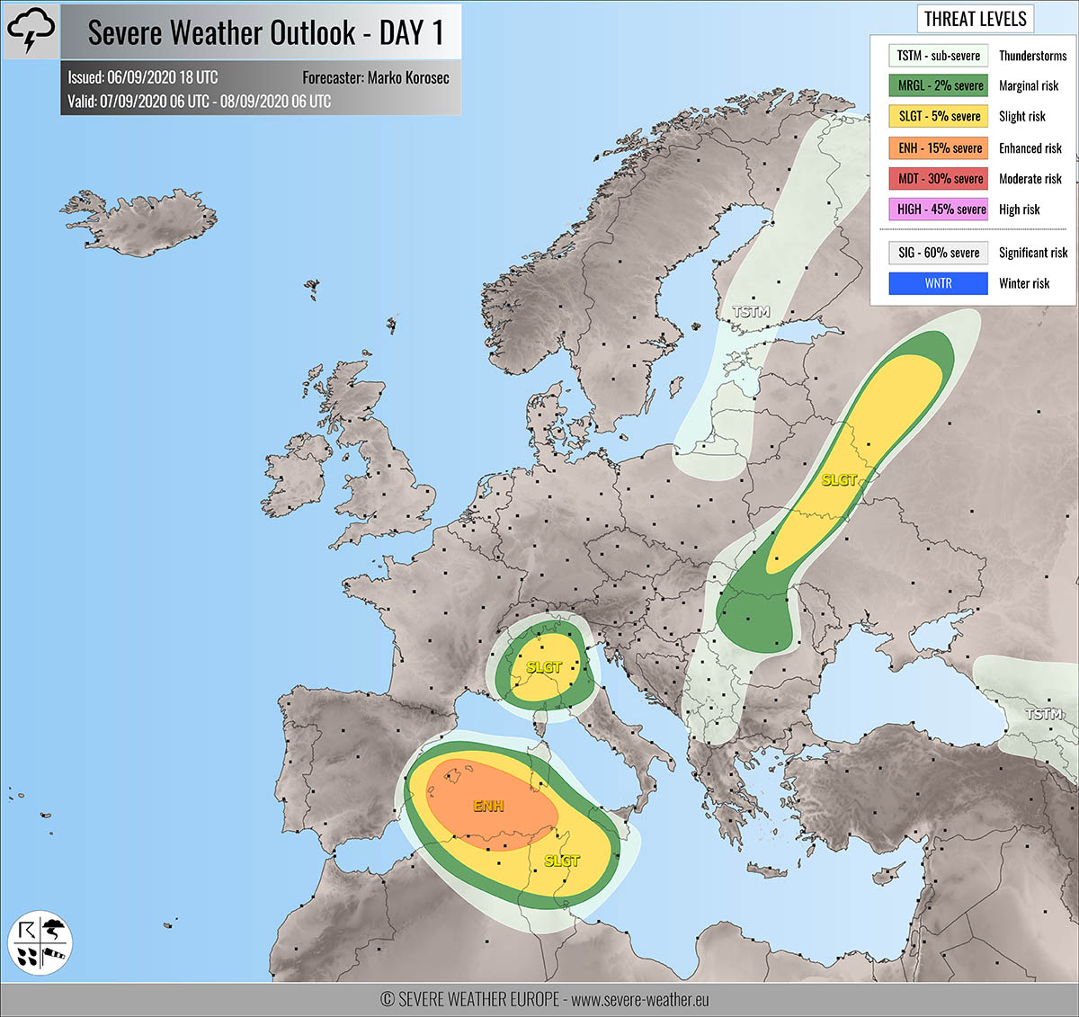
Severe weather outlook – forecast across Europe. This forecast features areas of organized severe weather with risk levels and severe weather threats across the European continent.
SEVERE WEATHER OUTLOOK – DAY 1
Valid: 07/09/2020 06 UTC – 08/09/2020 06 UTC
Issued by: Severe Weather Europe
Forecaster: Marko Korošec
SUMMARY
Severe storms with large hail, severe winds, tornadoes, and torrential rainfall are likely across the southwestern Mediterranean on Monday. Isolated severe storms are possible across northern Italy and eastern Europe.
Overview of the risk areas across Europe
SYNOPTIC OVERVIEW
A North Atlantic ridge moves south as a deep upper trough ejects from Greenland towards northern Europe. A short-wave with an associated surface front is crossing eastern Europe while weakening. An upper low deepens over the western Mediterranean.
FORECAST DISCUSSION
+++ western Mediterranean, Algeria and Tunisia +++
ENH/SLGT risks have been issued for the southwestern Mediterranean into northern Algeria and Tunisia with a threat for severe storms, capable of producing severe winds, tornadoes, torrential rainfall, and large hail.
Scattered to widespread organized storms are expected to form beneath a strengthening upper low. A moderate instability coupled with quite a strong shear should allow supercells to form from around Mallorca towards south-southeast.
Enhanced low-level shear and helicity could support tornadic events along the leading surface convergence moving south. While the main threat with supercells and storm clusters will be severe winds, torrential/excessive rainfall, and large hail.
The threat will be gradually moving southeast with time, towards Algeria, Tunisia, and Sicily, and should extend into Monday night.
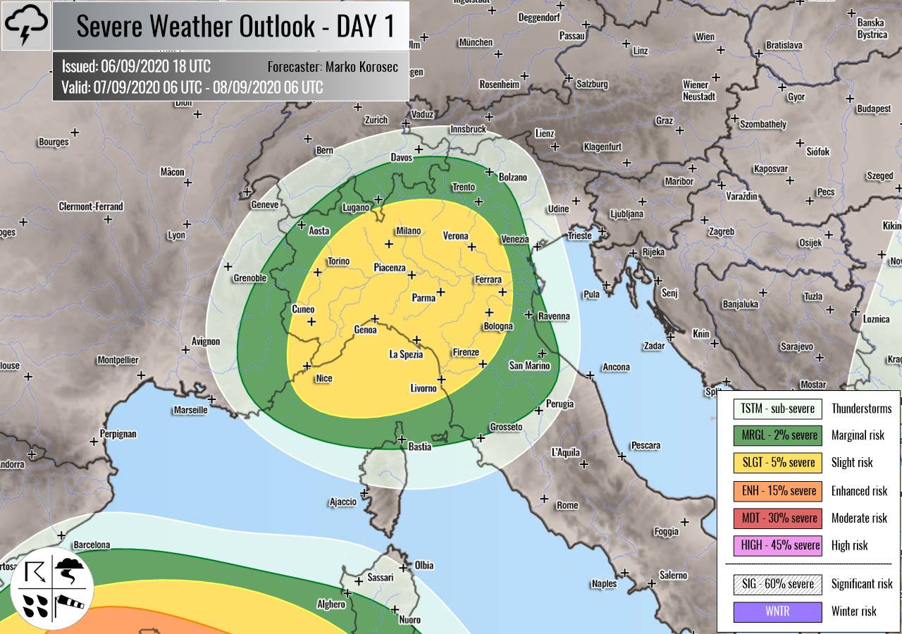
+++ north Italy +++
SLGT risk has been issued for parts of northern Italy with a threat for isolated severe storms, capable of producing severe winds, torrential rainfall, and marginal hail.
Around 1000 J/kg of CAPE should be available for storms forming in a weakly sheared environment. A few strong slow-moving multicells and possibly a supercell or two is likely to form during the day. The threat of torrential rainfall, marginal hail, and severe winds exist.
+++ Ukraine, Belarus and Russia +++
SLGT risk has been issued for western Ukraine into southeastern Belarus and western Russia with a threat for isolated severe storms, capable of producing severe winds, torrential rainfall, and large hail.
Convective initiation is expected along the weakening surface front during the afternoon hours. Although the strongest shear will be somehow decoupled with the strongest near 1000 J/kg instability, some organized storms including supercells are possible.
The strongest storms will be capable of producing some large hail and severe wind events.
+++ other areas +++
TSTM risks have been issued for the Baltic region into Finland and across Georgia, and central Balkans with a threat for daytime driven storms. Limited shear is present, so the storms should remain sub-severe.
Follow & report severe weather events on our Facebook page:
Severe Weather Europe Facebook page
Understanding Severe Weather Outlook
Severe Weather Outlook features areas of organized severe weather with risk levels and severe weather threats. Risk levels are divided into seven categories:
TSTM – Thunderstorms
MRGL – Marginal risk
SLGT – Slight risk
ENH – Enhanced risk
MDT – Moderate risk
HIGH – High risk
SIG – Significant risk
WNTR – Winter risk
Risk categories stand for the coverage and intensity of organized severe weather. Those could include supercells, squall lines, mesoscale convective systems, wind storms, flooding, snowstorms, or ice storms.
Severe weather threats include:
- large hail (of at least 2 cm in diameter)
- Tornadoes (including waterspouts)
- Wind gusts (convective or non-convective) above 25 m/s (or above 90 km/h)
- Torrential convective precipitation / Flash floods
- Excessive rainfall (100 mm within 12 hours) / snowfall (50 cm within 12 hours)
Extremely severe weather threats include:
- Large hail (of at least 5 cm in diameter)
- Tornadoes of F2 intensity or stronger
- Wind gusts (convective or non-convective) above 33 m/s (or above 119 km/h) or 12 Bft
- Torrential convective precipitation / Flash floods
- Excessive rainfall (150 mm within 12 hours or above ) / snowfall (above 100 cm within 24 hours)
Categories in the forecast represent the chance of severe weather occurring within a 40 km radius from a location. The used level is based on the conversion table of probabilistic risk into the outlook categories. A threat level is upgraded into a higher category if probabilities meet the threshold criteria for the specific threat (e.g. tornado, wind, hail, or rainfall threat).
Each individual threat area includes a detailed forecast map and discussion on the potential of severe weather threats.
Read more: Explanations for abbreviations (TSTM, SLGT, ENH, etc.)


