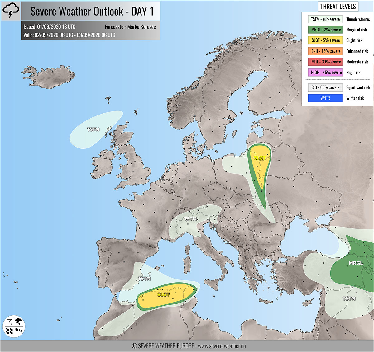
Severe weather outlook – forecast across Europe. This forecast features areas of organized severe weather with risk levels and severe weather threats across the European continent.
SEVERE WEATHER OUTLOOK – DAY 1
Valid: 02/09/2020 06 UTC – 03/09/2020 06 UTC
Issued by: Severe Weather Europe
Forecaster: Marko Korošec
SUMMARY
Severe storms are possible across northeast Poland, Lithuania, western Belarus, and northern Algeria with a threat for some large hail, severe winds, and torrential/excessive rainfall events on Wednesday.
Overview of the risk areas across Europe
SYNOPTIC OVERVIEW
Upper-level ridging is dominating a large part of western, northern, and eastern Europe. In between, two weakening upper lows are providing lift for convective weather, one centered over Czechia and another one moving into Algeria. A deep trough is developing over the North Atlantic. At the surface, a frontal system is moving towards northeast Europe. Another frontal system pushes into Ireland and Scotland.
FORECAST DISCUSSION
+++ Poland, Ukraine, Belarus and Lithuania +++
SLGT risk has been issued for eastern Poland into northwest Ukraine, western Belarus, and Lithuania with a threat for severe storms, capable of producing severe winds, torrential rainfall, and marginal hail.
Scattered severe storms are possible along the weakening frontal system. A rather strong shear but only marginal CAPE is available. Some storms could become supercellular and pose a threat for hail and severe winds.
+++ Algeria and Tunisia +++
SLGT risk has been issued for northern Algeria into Tunisia with a threat for severe storms, capable of producing severe winds, torrential rainfall, and marginal hail.
Isolated storms are possible within a moderately unstable and sheared environment, associated with the upper low. A few supercells will be possible, mainly with large hail and severe winds threat.
+++ other areas +++
MRGL risk has been issued eastern Turkey into Armenia and Georgia with a threat for severe storms, capable of producing marginal hail, severe winds, and heavy rainfall.
TSTM risks have been issued for eastern Spain, the Alps, the Middle East, and northwest of Scotland with a threat for daytime driven storms. Limited shear is present, so the storms should remain sub-severe.
Follow & report severe weather events on our Facebook page:
Severe Weather Europe Facebook page
Understanding Severe Weather Outlook
Severe Weather Outlook features areas of organized severe weather with risk levels and severe weather threats. Risk levels are divided into seven categories:
TSTM – Thunderstorms
MRGL – Marginal risk
SLGT – Slight risk
ENH – Enhanced risk
MDT – Moderate risk
HIGH – High risk
SIG – Significant risk
WNTR – Winter risk
Risk categories stand for the coverage and intensity of organized severe weather. Those could include supercells, squall lines, mesoscale convective systems, wind storms, flooding, snowstorms, or ice storms.
Severe weather threats include:
- large hail (of at least 2 cm in diameter)
- Tornadoes (including waterspouts)
- Wind gusts (convective or non-convective) above 25 m/s (or above 90 km/h)
- Torrential convective precipitation / Flash floods
- Excessive rainfall (100 mm within 12 hours) / snowfall (50 cm within 12 hours)
Extremely severe weather threats include:
- Large hail (of at least 5 cm in diameter)
- Tornadoes of F2 intensity or stronger
- Wind gusts (convective or non-convective) above 33 m/s (or above 119 km/h) or 12 Bft
- Torrential convective precipitation / Flash floods
- Excessive rainfall (150 mm within 12 hours or above ) / snowfall (above 100 cm within 24 hours)
Categories in the forecast represent the chance of severe weather occurring within a 40 km radius from a location. The used level is based on the conversion table of probabilistic risk into the outlook categories. A threat level is upgraded into a higher category if probabilities meet the threshold criteria for the specific threat (e.g. tornado, wind, hail, or rainfall threat).
Each individual threat area includes a detailed forecast map and discussion on the potential of severe weather threats.
Read more: Explanations for abbreviations (TSTM, SLGT, ENH, etc.)


