SYNOPSIS
A large deep trough / low remains over N Atlantic while ridge is strengthening across the ENE Europe. A weak short-wave crosses the Alps ith a surface front over the N Balkans. Weak upper low remains over E Mediterranean and W Turkey.
DISCUSSION
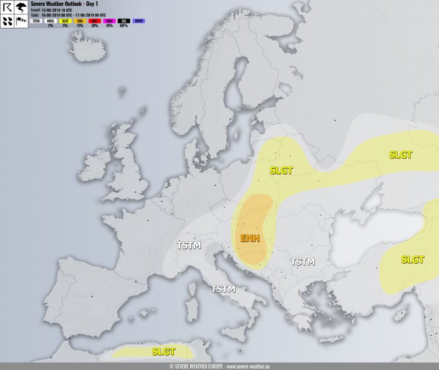
ENH risk has been issued for E Slovenia, N/E Croatia, E Austria, W Czechia, W-CNTRL Slovakia into S Poland and W-CNTRL Hungary, N Bosnia into NW Serbia with threat for severe storms, capable of producing severe winds, torrential / excessive rainfall and large to very large hail. Strong to extreme instability is again available over the risk area while surface winds should turn into NNE-erlies. Weak mid/upper-level winds are present aloft. This should result in elevated storms with back-building, so widespread multicell storms are expected with the tendency of clustering into a larger system across the southern half of the ENH risk through the evening hours. Locally, very large hail will be possible if some storms could gain better helicity with more easterly flow, as well as flash floods due to extreme instability and weak storm motion.
SLGT risk has been issued for areas surrounding the ENH risk across N Balkans, as well as across Poland, Belarus, Baltic states and N Ukraine into SW Russia with threat for more isolated severe storms, capable of producing severe winds, torrential rainfall and large hail.
SLGT risk has been issued for W Turkey into Georgia with threat for severe storms, capable of producing severe winds, torrential rainfall and large hail.
SLGT risk has been issued for N Algeria into NW Tunisia with threat for severe storms, capable of producing severe winds, torrential rainfall and large hail.
TSTM risk areas have been placed where convective storms are likely to occur but should remain sub-severe.


