SYNOPSIS
A strong ridge persists over ENE Europe while an upper low remains over the S Balkan peninsula. A deep trough over Atlantic drifts more east into WSW Europe with a surface cold front into France and Benelux.
DISCUSSION
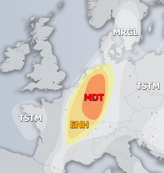
MDT / ENH risks have been issued for ENE France, E Benelux into W Germany with threat for severe storms, capable of producing severe winds, large to very large hail, torrential rainfall with flash floods and tornadoes. Widespread convective storms are expected within the strongly unstable and moderately sheared environment ahead of the front. Similar to a day before, scattered supercell storms initiation is likely during the mid-afternoon hours. Favorable LL shear and helicity should again develop threat for tornadic storms as well. Storms will likely merge into clusters with bowing segments towards the evening hours while spreading NNE-wards.
SLGT risk has been issued for areas surrounding the MDT / ENH risks including WNW Germany, E-CNTRL France into E Benelux where the more isolated threat for severe storms exists. These storms should be capable of producing large hail, severe winds and torrential rainfall.
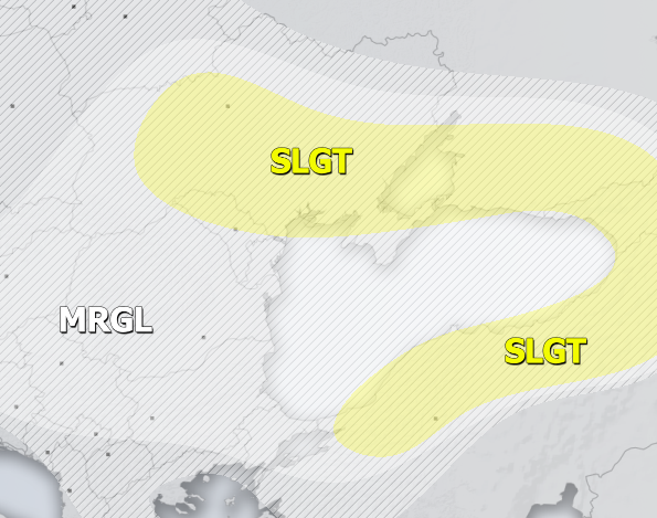
SLGT risk has been issued for NNE Turkey, Georgia into SW Russia and S Ukraine with threat for severe storms, capable of producing severe winds, torrential / excessive rainfall and large to very large hail. Strong instability overlapping with moderate shear should result in widespread organized storms with local flash floods as well.
MRGL risk has been issued for areas surrounding the SLGT risk including Balkan peninsula where isolated severe storms are possible, capable of producing severe winds, torrential / excessive rainfall and large hail. Slow moving storms are expected within moderate MLCAPE but weak shear.
SLGT risk has been issued for NW Russia with threat for isolated severe storms are possible, capable of producing severe winds, torrential / excessive rainfall and large hail.
TSTM risk areas have been placed where convective storms are likely to occur but should remain sub-severe.
Weekly overview:


