Very heavy torrential rainfall continues over parts of nothern Italy, slowly spreading soutwards across the Tuscany region which is included in the MDT+ risk area on DAY 1 Outlook for 21/10/2013.
Intense cluster of maintaning storms as seen on visible satellite image. Source: EUMETSAT
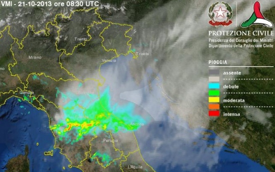
Severe cells with torrential rainfall as seen on latest radar scans. Source: Protezione Civile Italy
Storms initiated on the stationary boundary / instability axis in the mid afternoon on Sunday (refer to update 1 and update 2 yesterday) where numerous severe storms with torrential rainfall have been maintaining for more than 12 hours. Impressively high rain accumulations have been reported so far, with some weather stations reporting as high as near 350 mm in only 12 hours (overnight)! Major flooding has been reported from some areas.
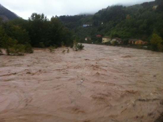
High rivers in Tuscany. Source: MeteoWeb.eu
These are overnight (12 hours) rainfall accumulations from 18:00 UTC yesterday until 06:00 UTC this morning over NW Tuscany:
- 344.0 mm / 12h – Barga
- 310.4 mm / 12h – Gallicano
- 297.8 mm / 12h – Fornovolasco – Vergemoli
- 290.4 mm / 12h – Ponte di Campia
- 240.2 mm / 12h – Acquerino – Sambuca Pistoiese
- 223.2 mm / 12h – Careggine
- 223.0 mm / 12h – Cardoso – Stazzema
- 208.4 mm / 12h – Campagrina – Stazzema
- 205.8 mm / 12h – Tereglio – Coreglia Antelminelli
- 204.2 mm / 12h – Pian di Novello – Cutigliano
- 201.8 mm / 12h – Calavorno – Coreglia Antelminelli
Fornovolasco – Vergemoli station received impressive rainfall accumulation of 204.4 mm in 4 hours between 22:30 UTC and 02:30 UTC while station Careggine received 140.2 mm in only 2h between 20:00 and 22:00 UTC! Truly remarkable numbers which usually results in serious flash floods.
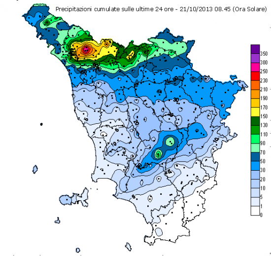
Here are the total rainfall accumulations so far in the last 24 hours (from 06:00 UTC yesterday until 06:00 UTC today):
Rainfall accumulations in Tuscany region. Source: cfr.toscana.it
And more detailed in the list below:
- 353.6 mm – Barga
- 318.6 mm – Gallicano
- 305.2 mm – Fornovolasco – Vergemoli
- 293.0 mm – Ponte di Campia
- 240.6 mm – Acquerino – Sambuca Pistoiese
- 232.8 mm – Careggine
- 225.8 mm – Cardoso – Stazzema
- 222.6 mm – Pian di Novello – Cutigliano
- 218.2 mm – Campagrina – Stazzema
- 215.6 mm – Tereglio – Coreglia Antelminelli
- 208.8 mm – Calavorno – Coreglia Antelminelli
- 204.6 mm – Terrinca – Stazzema
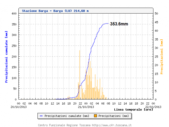
Total rainfall of 353.6 mm in 12 hours in Barga, Tuscany. Source: cfr.toscana.it
Total rainfall of 318.8 mm in 12 hours in Gallicano, Tuscany. Source: cfr.toscana.it
Lightning activity with these storms have been remarkable over Liguria, Tuscany and Emilia Romagna regions overnight. A sign that very high instability has been in place, supporting continuous torrential rainfalls in several waves.
Lightning activity during the last 24 hours over Italy. Source: Boock.ch
Flooding in Tuscany. Source: MeteoWeb.eu
Additionally, between 100 and 180 mm have fallen over Liguria and in Emilia Romagna regions. More data will be available later.
Rainfall accumulations in Liguria region. Source: www.meteoliguria.it
Follow the ongoing severe storms on Italy radar and satellites pages.


