The latest forecast update for Summer 2023 shows interesting trends developing. Weather patterns look more diverse over North America, with the strong onset of an El Niño event, while high-pressure atmospheric blocking is trending for Europe.
When trying to understand any weather season and long-range forecasts, we must understand its global drivers. Global weather is a very complex system with many large-scale and small-scale factors.
Seasonal forecasting focuses on large-scale pressure systems and jet stream positioning. Over the Northern Hemisphere, this upcoming Summer season will be a transition period between the La Niña and the El Niño, which is now emerging with a growing atmospheric influence.
But first, we will quickly recap the first two months of the Spring season and the drivers behind them.
POLAR VORTEX CIRCULATION
The processes that affected the first half of the Spring season have occurred in different parts of the atmosphere. This is because there are many layers to the atmosphere, and our weather unfolds in the lowest layer of the atmosphere, called the Troposphere.
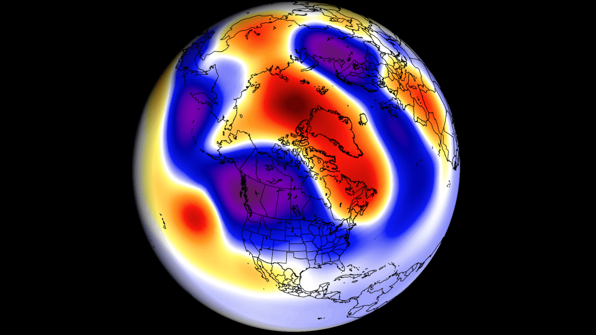
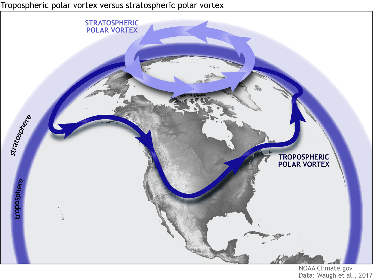
But above that, we have the Stratosphere, also the home of the ozone layer. Both layers have their own circulation and are connected in many different ways. The main overall circulation is what we call the Polar Vortex.
That is why we separate the entire Polar Vortex into an upper (stratospheric) and a lower (tropospheric) part. They both play their role differently, so we monitor them separately. But how they are connected is also very important—image by NOAA-Climate.
A Sudden Stratospheric Warming event (SSW) occurred in February and early March. These events usually mean a breakdown of the stratospheric circulation, with the resulting energy gradually moving downwards, impacting the weather in the lower levels.
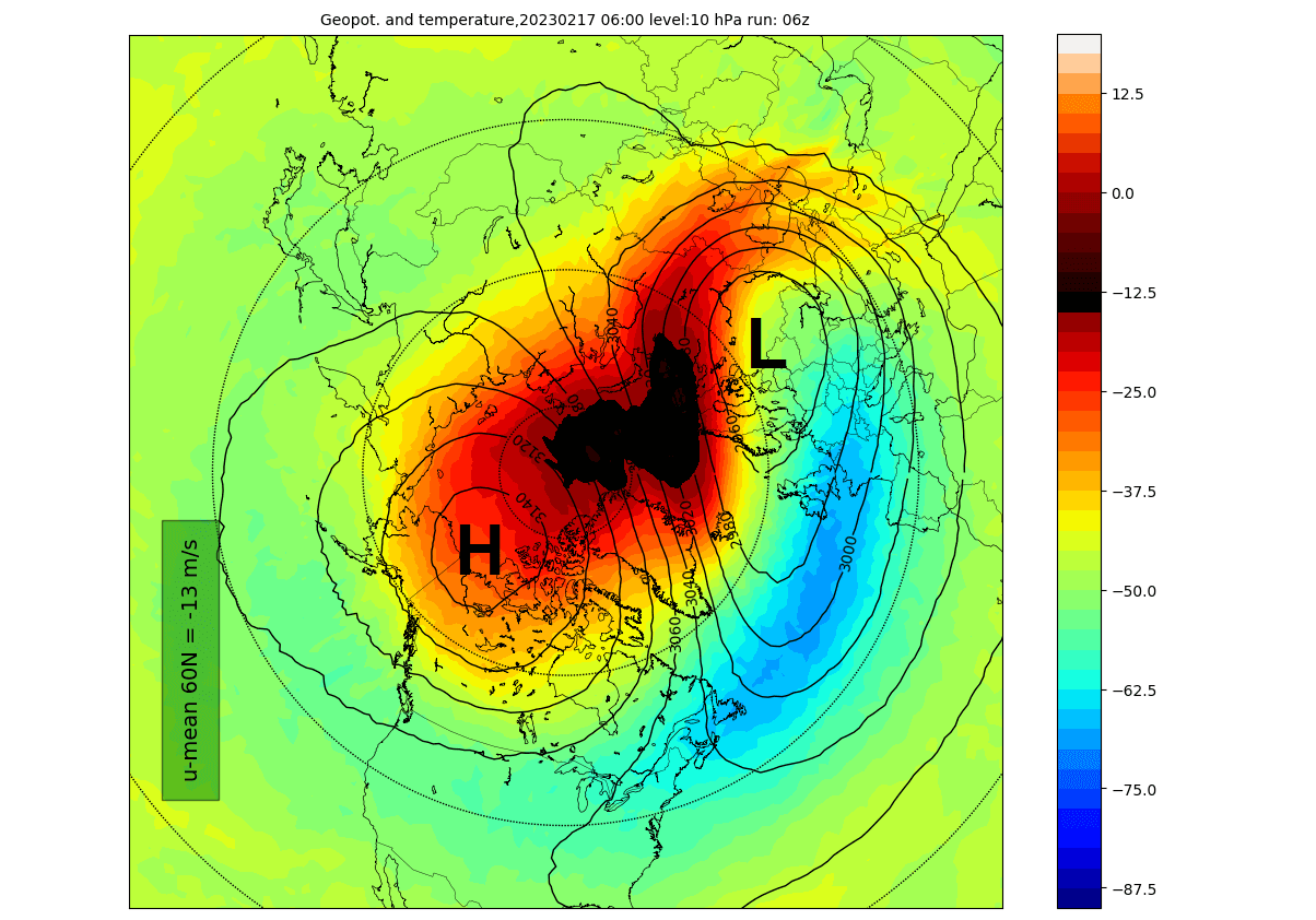
Looking at the first day of the SSW event below, you can see a large warming wave in the Stratosphere. It spread over the polar regions. Combined with a strong emerging polar “anti-vortex” covering the North Pacific and western Arctic (H), it has pushed and displaced the Polar Vortex (L) out of the North Pole.
In the next image below, you can see the temperature anomaly for the same mid-stratospheric levels. It better highlights the actual sudden stratospheric warming event. Again, you can see that the temperatures were raised well above normal levels, as shown by the strong anomalies, helping to break down the polar circulation.

The whole process can be better seen in the video animation below, showing how the Polar Vortex started over the North Pole in the Stratosphere. But a strong high-pressure area and a warming wave have weakened the Polar Vortex and pushed it out.
A strong influx of energy from below into the Stratosphere created this major disruption and warming, completely collapsing the upper stratospheric Polar Vortex.
The best way to follow SSW effects development is to look at atmospheric changes over time. Below is a graphic showing the pressure anomalies across the atmosphere over time.
Negative values indicate higher pressure (red anomalies), and positive values indicate lower pressure (blue colors). The vertical axis shows altitude from the ground up to the top of the Stratosphere (~46km/28mi).
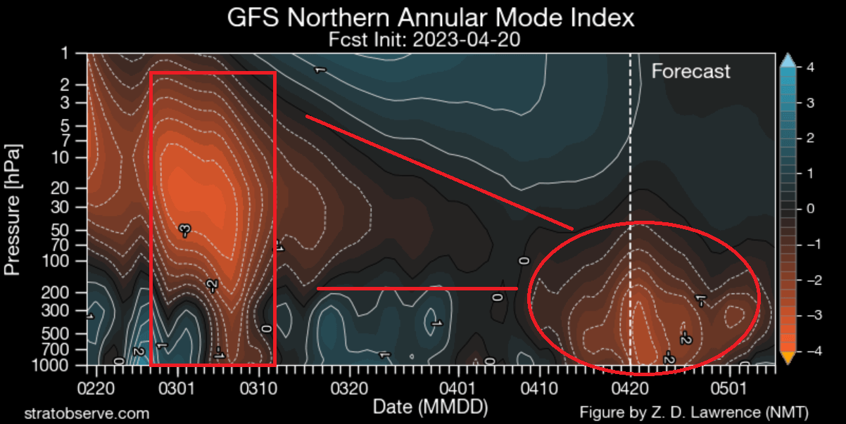
In early March, high-pressure anomalies from the Stratosphere connected down to the lower levels. This was a direct impact. But a more gradual process continued in the lower Stratosphere.
You can see in the image above that the high-pressure anomalies persisted and helped to amplify the blocking pattern in late April and early May. As always, other background influences exist, but the stratospheric warming effects played their role as expected.
SPRING 2023 WEATHER PATTERNS
The meteorological Spring season covers the months of March, April, and May. As mentioned above, the Stratospheric warming events impacted the spring weather season.
The pressure analysis below for March and April shows a large, strong, high-pressure anomaly over Greenland and eastern Canada.

That is the high-pressure zone instigated by the Polar Vortex collapse. As a response, you can see the low-pressure zones covering the Atlantic and Europe and an even stronger system over the western United States.
A high-pressure ridge zone was over the eastern United States, connecting with the high-pressure over Greenland.
TEMPERATURE ANALYSIS
Below you can see the temperature anomalies over Europe for the same 2-month period. Again, warmer-than-normal weather was recorded over the western and eastern parts. But normal to cooler conditions prevailed over central Europe, while colder temperatures were recorded in northern Europe.
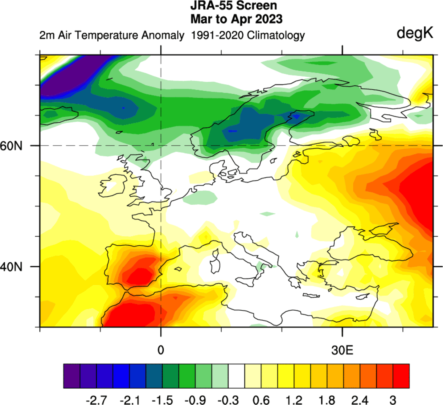
The temperature analysis of the United States and Canada shows a broad cold area. This is the colder-than-normal air present over southern Canada, the upper Midwest, and much of the western United States.

The cold anomaly area was the effect of the low-pressure system over the western United States. At the same time, a ridge in the east kept the temperatures mostly warmer than normal.
PRECIPITATION ANALYSIS
The precipitation pattern over Europe was wetter over much of the continent. The exception was southwestern Europe, with drier conditions under a high-pressure system.

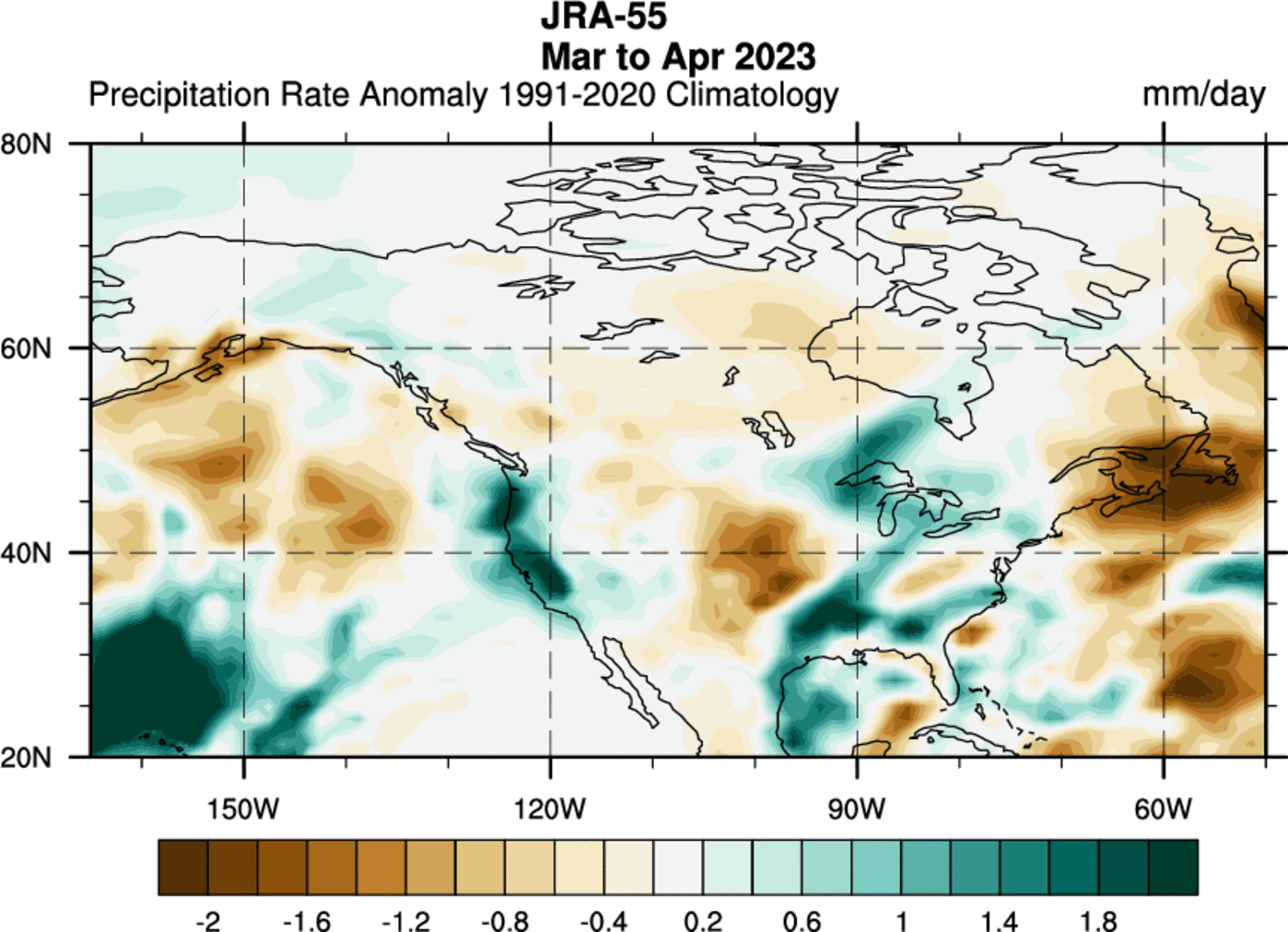
The analysis of North America shows less precipitation and drier conditions over the central United States. But there was more precipitation over the west coast, the Ohio River Valley, and the Great Lakes. More precipitation was also recorded over parts of south/southeastern Canada.
But as we mentioned in the intro, a new ocean anomaly is rising, namely the El Niño event in the tropical Pacific Ocean.
EL NINO RISING
One of the larger drivers behind the seasonal weather patterns is typically the ENSO, short for the El Niño Southern Oscillation. The cold phase of ENSO is called a La Niña, and the warm phase is called an El Niño. Each phase specifically influences the pressure patterns and the resulting weather.
We have been in a cold ENSO phase (La Niña) for three years. But now, the oceans are shifting rapidly into a warm phase called the El Niño.
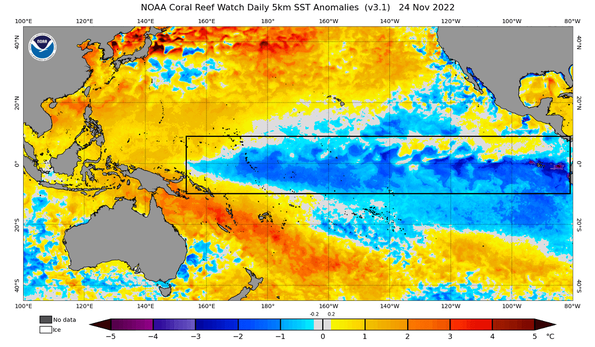
Speaking of La Niña, below is the ocean temperature analysis from late November 2022 before Winter began. You can see the cold ocean anomalies extending across the tropical Pacific. This was the mature active La Niña.
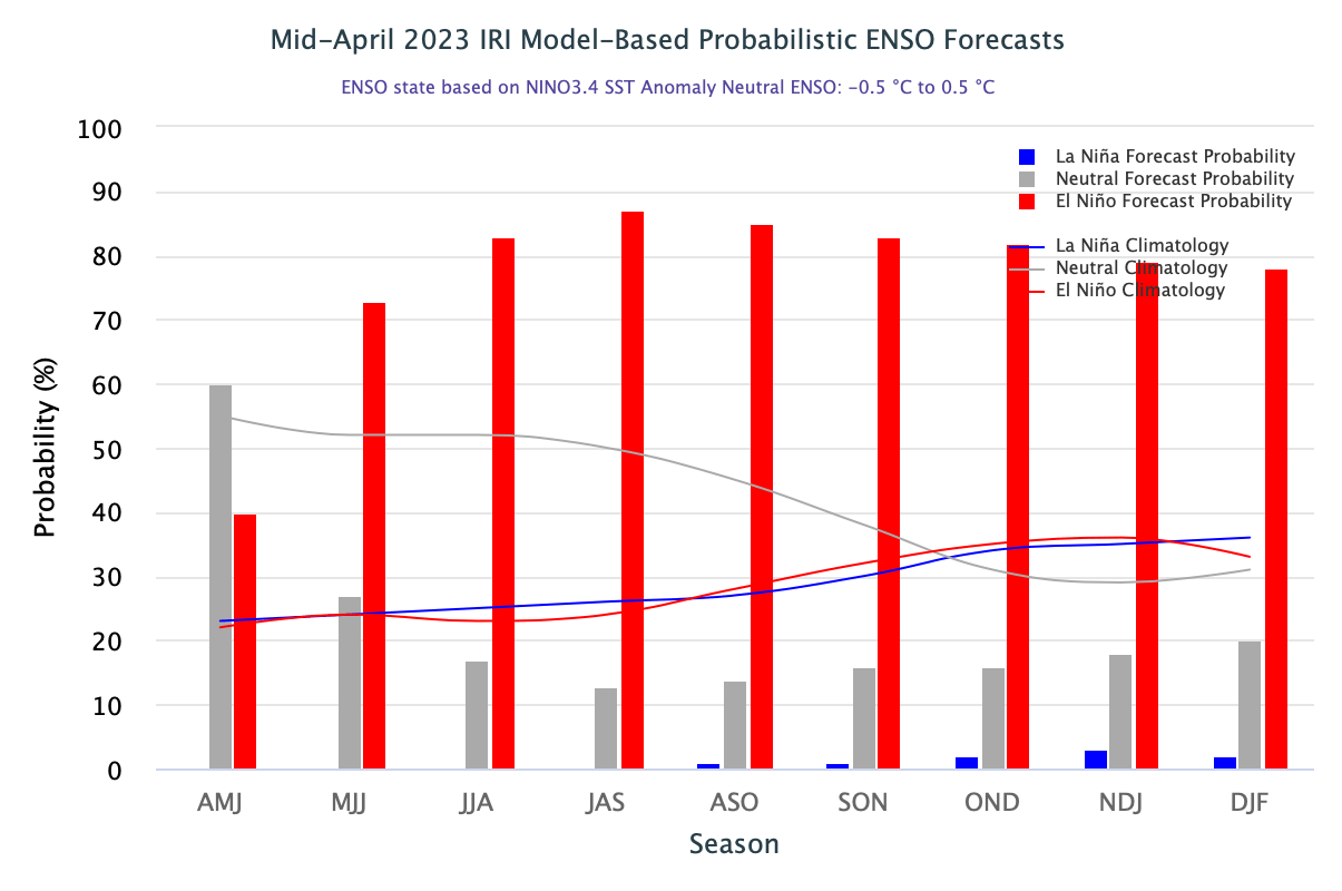
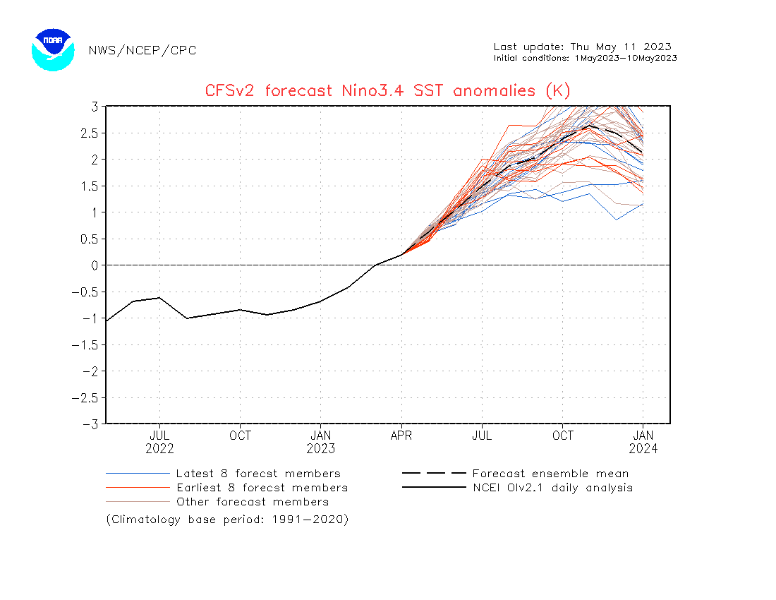
Looking below at the ENSO outlook from IRI, you can see a fast El Niño onset, with high probability. The oceanic El Niño conditions are expected to be present over Summer, lasting into the foreseeable future.
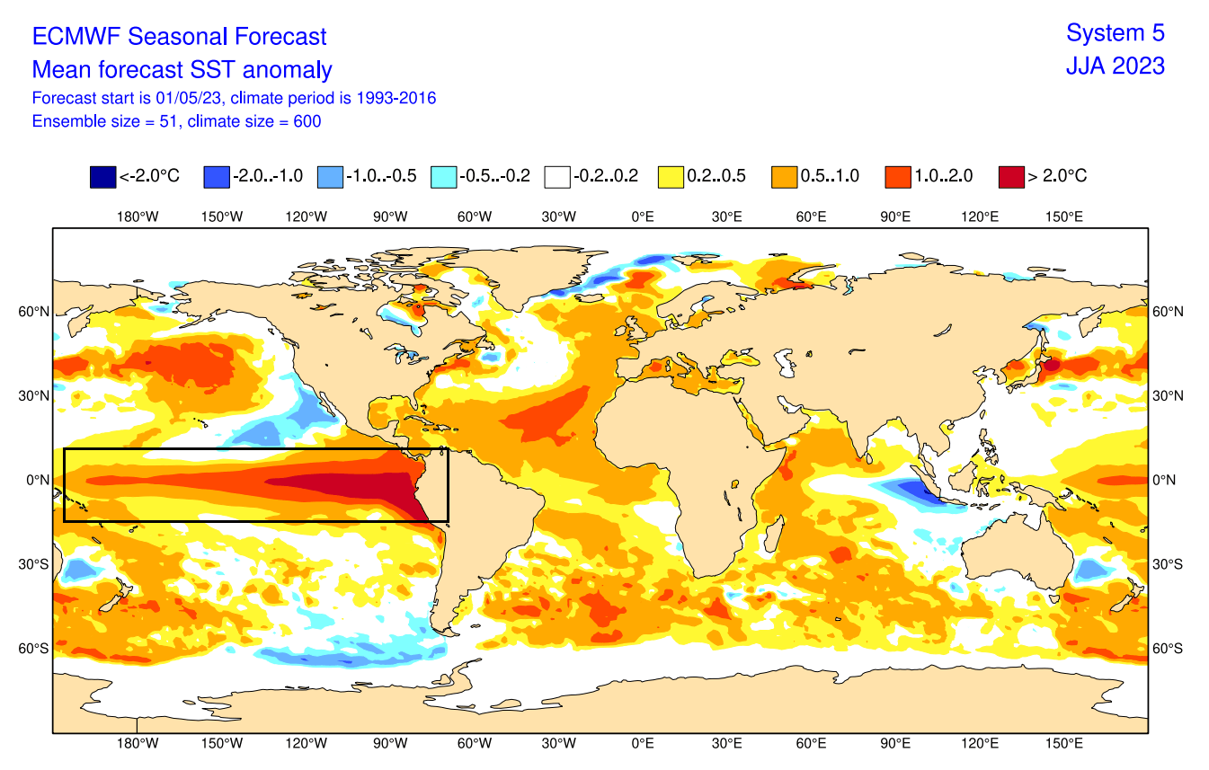
Below we have the ECMWF long-range ocean forecast, showing the temperature anomalies during Summer. A strong belt of warm anomalies extends across the tropical Pacific. If the forecast verifies, this would be a strong El Niño event with important global weather influence.
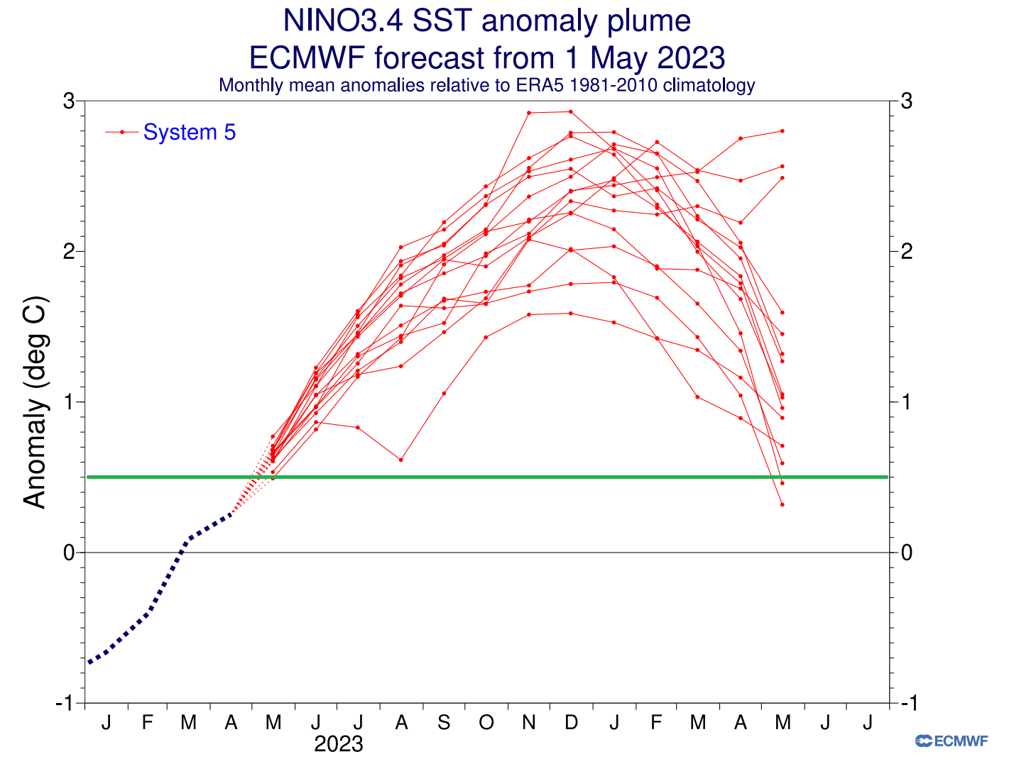
Looking at the extended seasonal ENSO forecast from ECMWF, you can see the ensemble consensus for a rather strong El Niño event. The green line is the El Niño threshold (+0.5 degrees). The anomalies are forecast to peak into the strong territory, lasting well into 2024.
But it’s time to look at the early weather trends for Summer 2023 across Europe, Canada, and the United States.
SUMMER 2023 SEASONAL FORECAST
We will examine the early trends from the two most used seasonal forecasting systems. The ECMWF from Europe and the CFSv2 from NOAA in the United States. We like using two very different forecasting systems because it helps us to see more potential scenarios. It also helps to see how well the model agrees on a certain trend.
ECMWF SUMMER SEASON FORECAST
We often use the ECMWF model, as it is generally considered the most reliable. But no long-range/seasonal forecasting system can ever be called “reliable“. This is because we only look at trends and how the weather patterns are evolving on a large scale and over longer periods.
The forecast period we will focus on in all models is June-July-August (JJA 2023). This period covers the meteorological Summer and presents the peak of the warm season.
The pressure pattern forecast from ECMWF below shows a high-pressure area over eastern Canada and Greenland and low-pressure under it, spanning the Atlantic and the United States. This will amplify the subtropical jet stream.
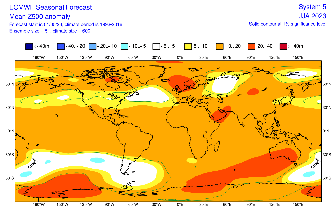
A stronger high-pressure area is found over northwestern Europe, specifically the United Kingdom, Ireland, and western Scandinavia. Such a strong system can have a widespread influence on the Summer weather patterns in Europe.
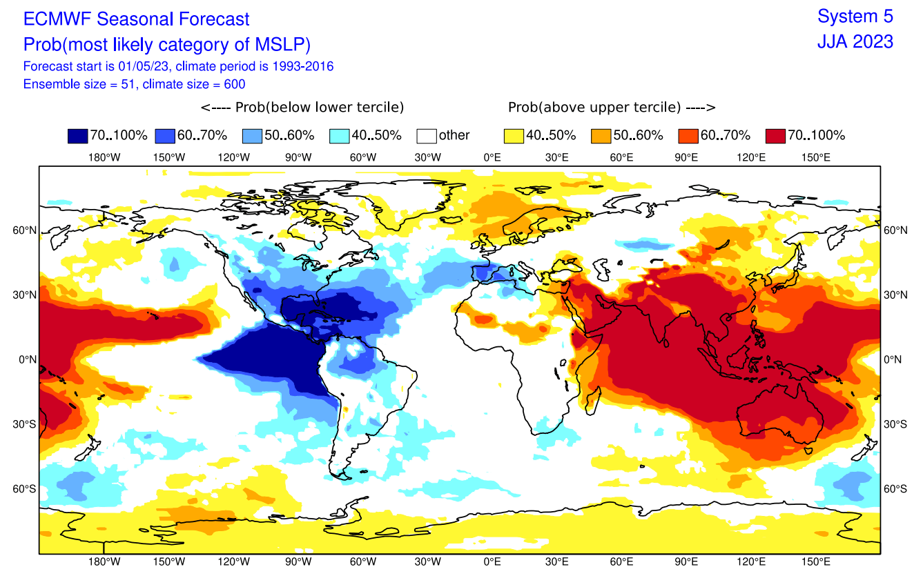
The surface pressure anomaly also shows an interesting pattern over the tropical Pacific. A broad low-pressure zone is forecast to cover the eastern Pacific tropics and the Caribbean. That indicates an emerging El Niño pattern. In addition, a low-pressure area is seen over the United States and a high-pressure zone over Greenland and northern Europe.
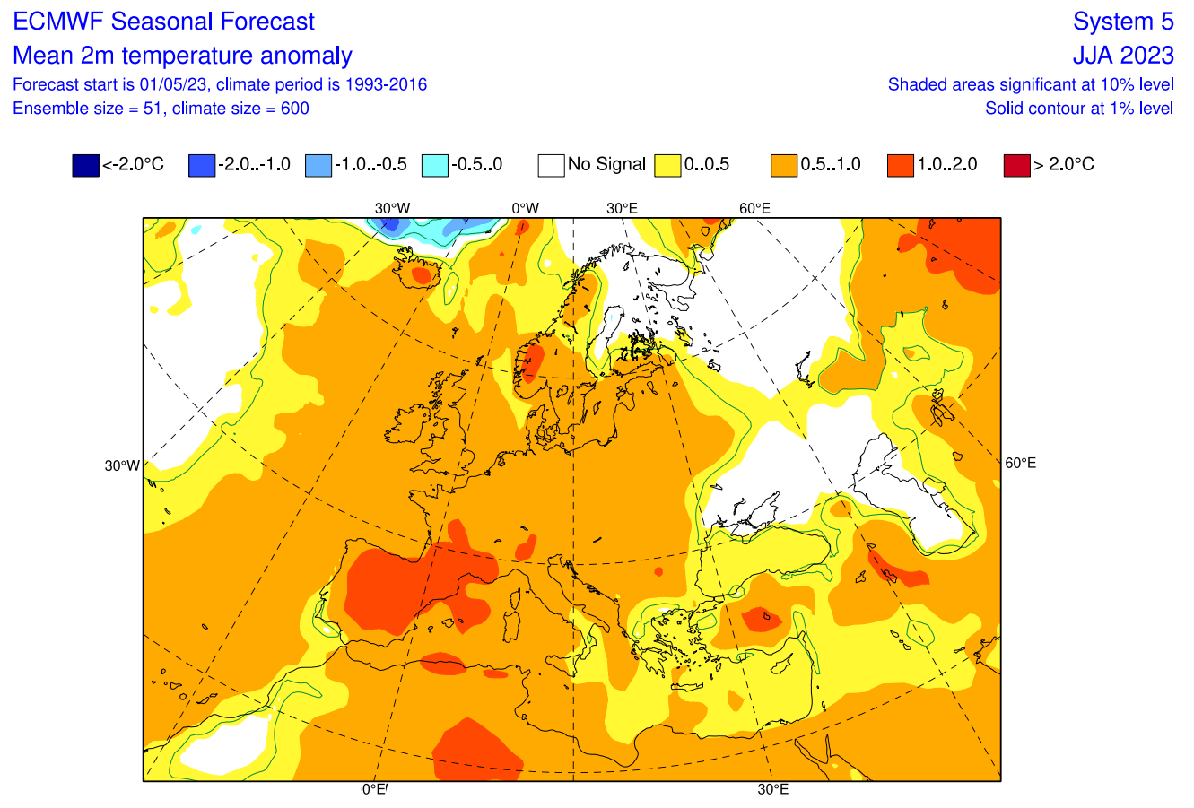
Looking closer at the temperature pattern over Europe, we see warmer-than-normal weather over most of the continent, especially over the southwest. But the exception is found towards the northeast, currently forecast to be under the influence of a northerly flow. This is because the clockwise rotation of the high-pressure system over northwestern Europe creates that northerly flow.
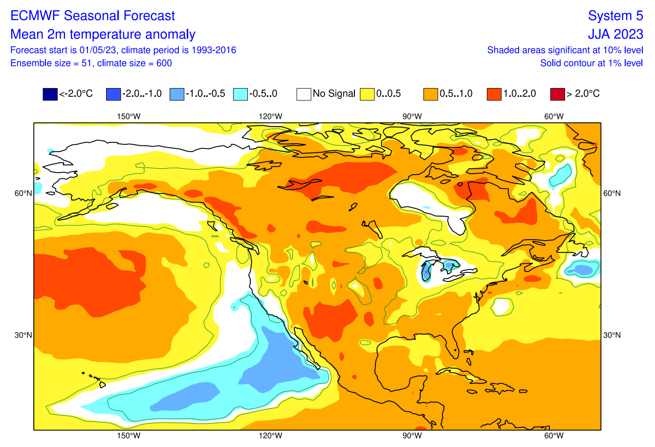
Over North America, we can now see mostly warm anomalies over much of the central and northern United States and Canada. Some exceptions are over the west coast of the United States. A normal to cold anomaly is forecast around the Great Lakes.
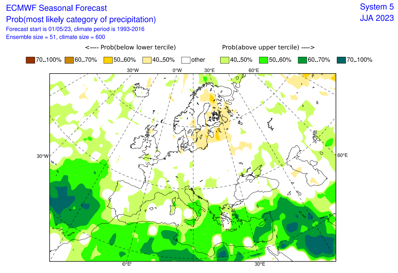
Going to precipitation, we can see mostly drier conditions forecast over northern Europe under the high-pressure zone. However, wetter conditions are forecast over the south-central parts of the continent, also indicating a more active storm season.
The precipitation forecast over North America shows drier conditions over the southwestern United States and parts of southern and central Canada. However, more precipitation is expected in the southern United States and the southern Great Lakes.
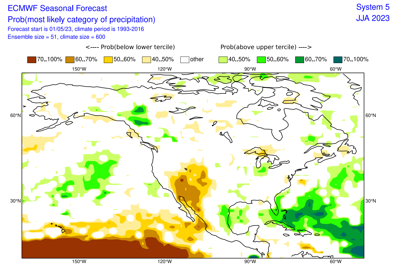
The highest probability for drought conditions is forecast over the southwestern United States.
CFS SUMMER 2023 FORECAST
In contrast to the European models, we like to use the main North American long-range model, the CFS version 2 from the NOAA/NCEP in the United States.
Looking at the CFS ENSO forecast, you can see it also shows a moderate to strong El Niño event developing. It is forecast to peak during late Fall and early Winter, lasting into the first half of 2024.
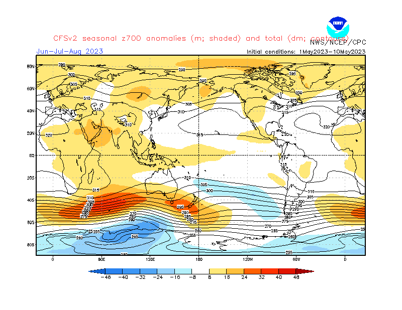
The CFS model differs from the ECMWF, with a high-pressure system over western Canada and Greenland. A low-pressure zone is indicated in such a setup over the eastern United States and southeastern Canada. Europe is sitting under a high-pressure system, similar to the ECMWF forecast.
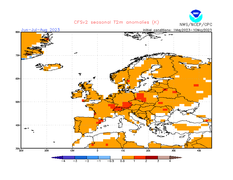
Looking closer at Europe, the surface temperatures are warmer than normal over most of the continent. A stronger warm anomaly is forecast over central Europe under the influence of a blocking system.
The North American temperature forecast below shows an interesting picture. You can see mostly neutral temperatures and even some hints of colder-than-normal areas over the Rockies. On the other hand, warmer areas are over the far western United States and much of Canada, under high pressure.
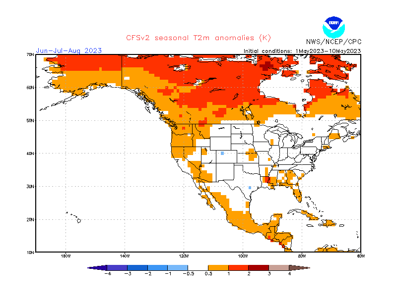
The southeastern United States is also forecast to be warmer than normal. But overall, we can see the CFS does not forecast a scorching hot summer over the United States, except for the southeastern and southwestern parts.
Looking at precipitation over Europe, we see mostly wetter Summer conditions across the south-central continent. This is also a sign of a potentially stronger storm season if this forecast would verify. Drier conditions are forecast over parts of central Europe and western Scandinavia.

Over North America, you can see a mostly drier Summer over southern Canada, Alaska, and over the eastern United States. But wetter conditions are forecast over much of the rest of the United States, with more precipitation over Florida and the northeastern United States.
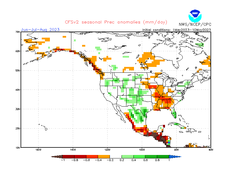
This strongly contrasts with the ECMWF forecast, which shows drier conditions over the western United States. This difference is normal between long-range models. But what is likely happening is that the models have a harder time understanding the influence of the emerging El Niño event.
SUMMER 2023 NOAA UNITED STATES FORECAST
The latest NOAA official Summer temperature outlook shows that most of the United States is expected to be warmer than normal. The core warm anomalies are so far focused on the southwestern parts of the United States and the east coast.
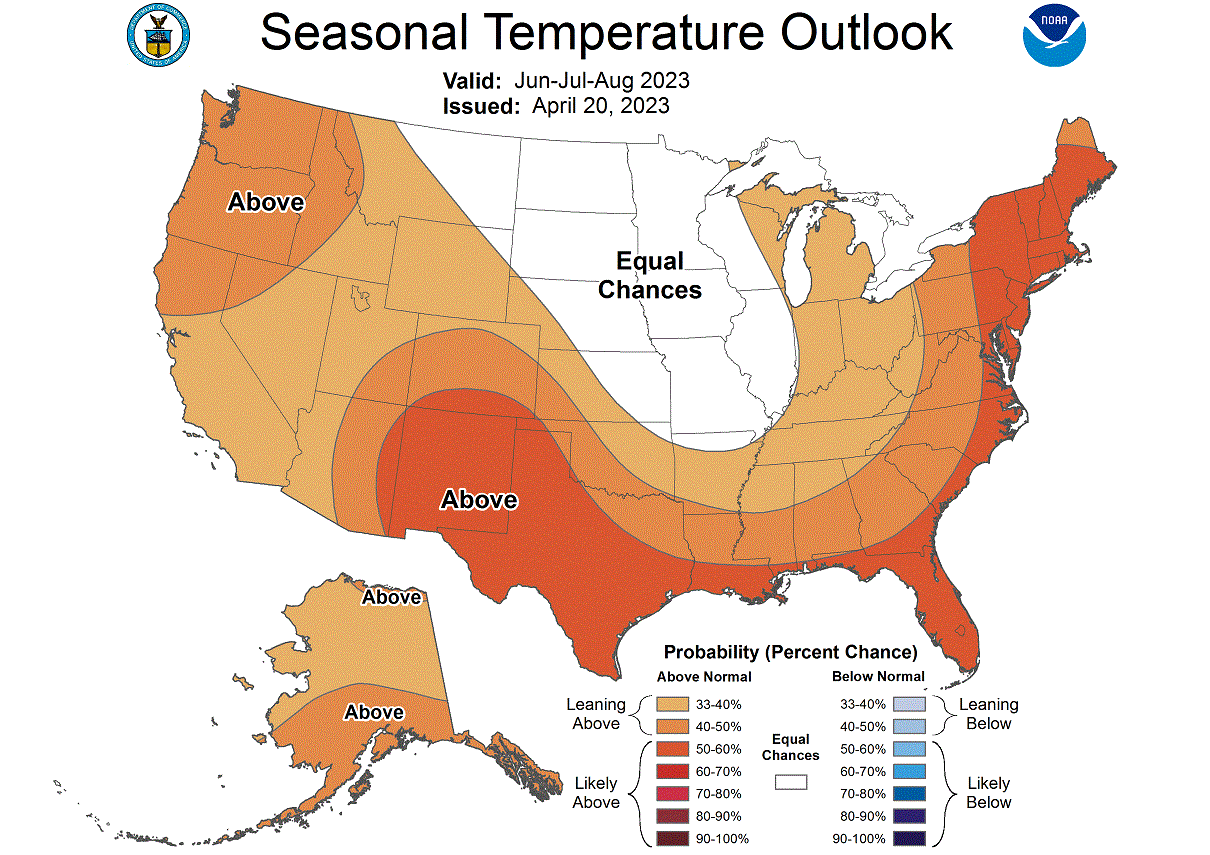
You can see that an area of normal temperatures covers the upper Midwest, creating a gap down to the central states.
The official Summer precipitation outlook is quite similar to the model forecast. We see an equal-to-higher probability for more precipitation over the eastern United States. NOAA expects drier conditions over the southwestern and northwestern United States.
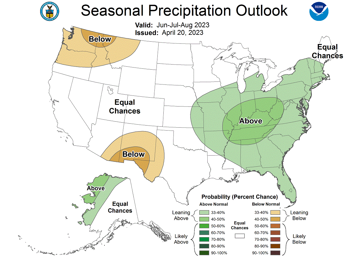
Both models also had a slight tendency for drier conditions over the Pacific Northwest, so this is also a similar idea. But the agreement is smaller than for the high precipitation over the northeast, which is a more high-confidence scenario.
We will release regular updates as fresh forecasts and data are available. So make sure to bookmark our page. Also, if you have seen this article in the Google App (Discover) feed, click the like button (♥) there to see more of our forecasts and our latest articles on weather and nature in general.
SEE ALSO: