Spring season 2022 is nearing, with forecasts revealing the jet stream pattern over the North Pacific and the Atlantic to be influenced by the now weakening La Nina. A high-pressure system in the Pacific will define the dynamic weather over North America, while a westerly flow is shaping for Europe.
When trying to understand any weather season and the forecasts, we must realize that there are many “drivers” that can shape it. Global weather is a very complex system, with many large-scale and small-scale climate influencers.
Some of these drivers are large and strong enough to be forecasted to a fair extent even in the more extended range. That can give us an idea of the prevailing weather patterns a few weeks to months ahead.
Of course, we are not looking at the actual temperatures and precipitation from city to city, as that is impossible. But we can look at the large-scale pressure systems and the positioning of the jet stream over the Northern Hemisphere, in the first Spring 2022 seasonal forecast.
WINTER 2021/2022 SO FAR
Just over half of the meteorological winter season is already behind us. We will quickly look at how it evolved so far with monthly temperature anomalies and the pressure patterns that drove the winter weather so far. The meteorological winter season covers the December-January-February period, so we will look at December and half of January so far.
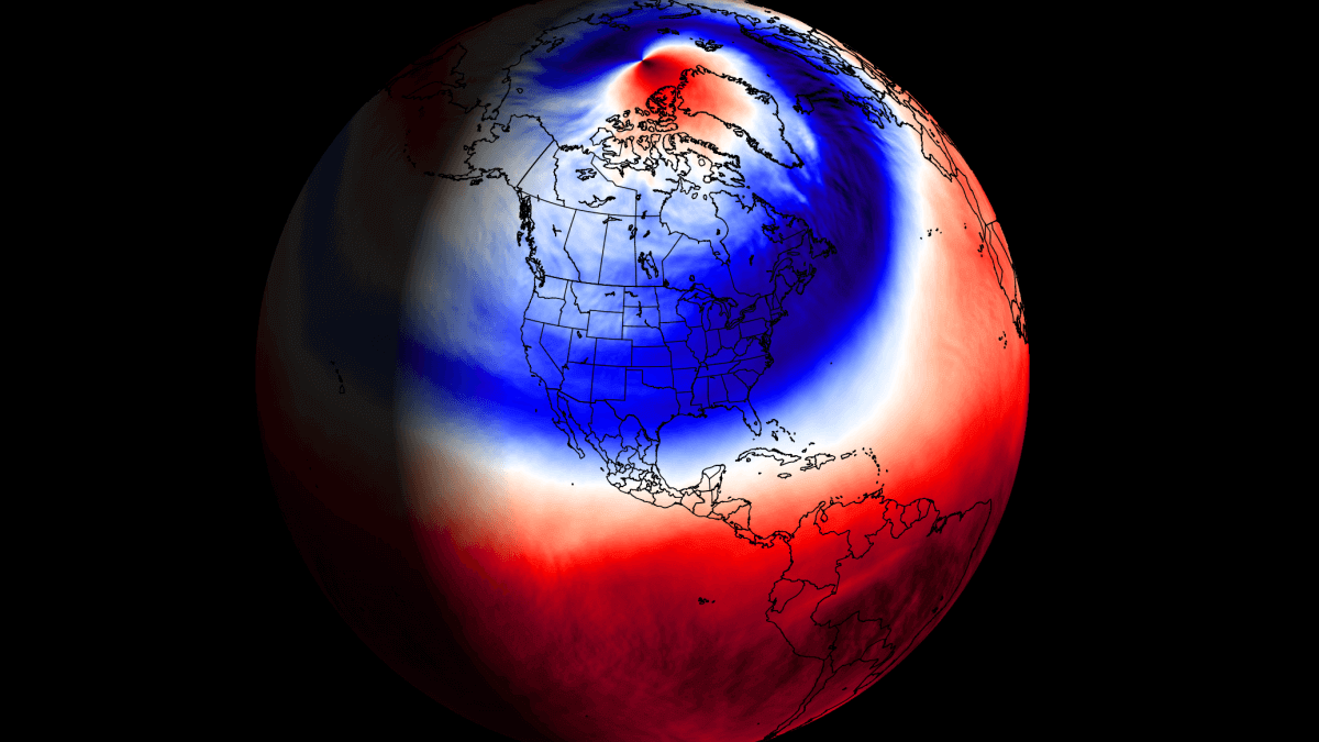
Below we have the pressure pattern from December 1st to January 17th. what stands out is the strong semi-permanent high-pressure system in the North Pacific. Also, as a response to that, we have a broad low-pressure area over western Canada, covering also the northwestern United States and Alaska.

Such a pattern drives the jet stream down over the northwestern United States and up into eastern Canada. That helps to develop and sustain a ridge over the southeastern United States, bringing milder/warmer conditions.
Over Europe, we have a ridge present over western Europe up into the North Atlantic. That means a low-pressure rea is to the east of the ridge, bringing colder weather to Scandinavia.
Speaking of temperatures, below we have the global temperatures for last December. We can actually see a lot of cold anomalies in the Polar and sub-polar regions, north of the 60N latitude. The exception is the Greenland area, under a high-pressure system.
Looking closer at December over North America, we can see the strong warm anomalies across much of the United States. The strongest warmer than normal temperatures are found in the south-central states, reducing fast towards the northern border. Cold air in western Canada was a regular source of cold fronts for the northwestern United States.
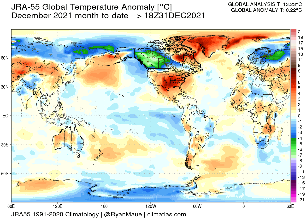
Over Europe, we see the cold air over Scandinavia and warmer conditions over most of central and western Europe. For the rest of the world, a notable anomaly was colder than normal conditions over eastern Australia and warmer than normal conditions over much of central and western parts.
In January so far, the picture is somewhat different. We have colder temperatures extending down into the south-central and northeastern United States. That is thanks to the jet stream dropping further down over the United States, removing the ridge over the southeast.

Over Europe, the pattern was different than last month, with warmer than normal weather prevailing over central regions and normal to colder over the west.
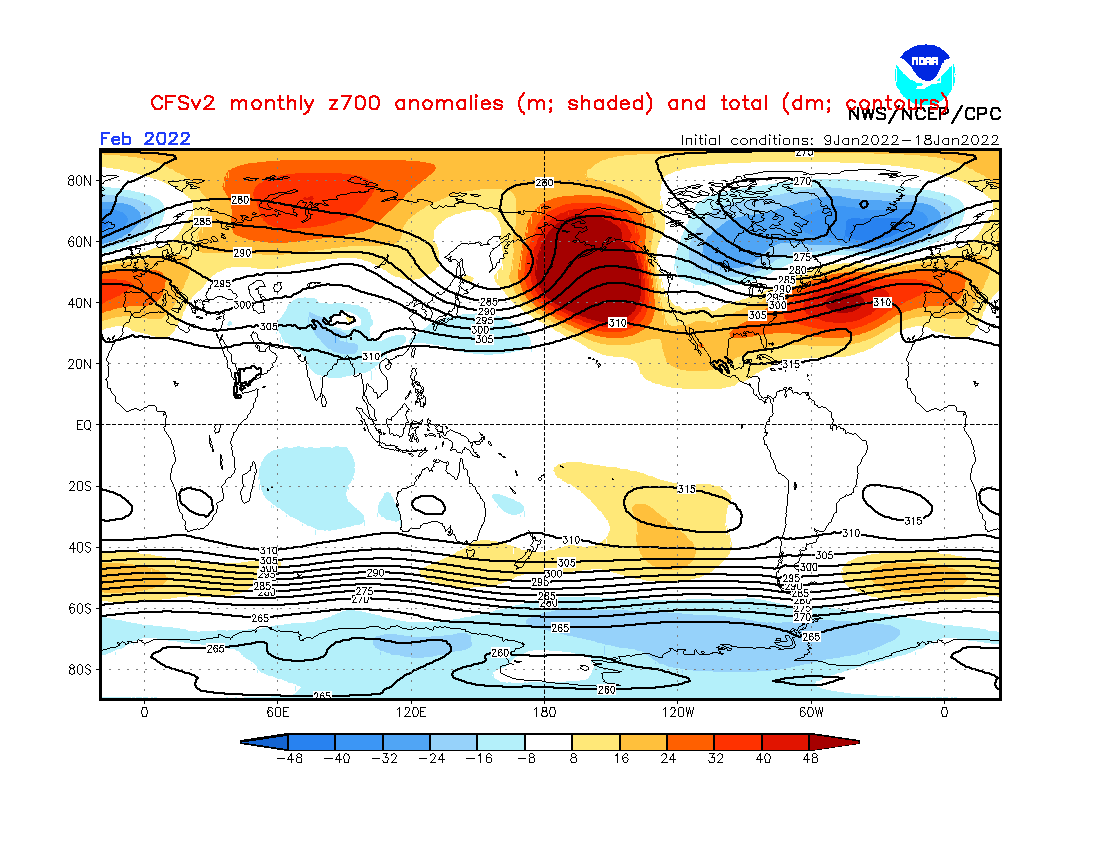
Going ahead into the last winter month of February, we have the pressure pattern forecast below from the United States CFSv2 model.
A strong high-pressure system in the North Pacific is the main driver of the North American weather regime. As a response, low-pressure remains over Canada, bending the jet stream down over the northwestern United States, and then up into eastern Canada.
Looking at the global temperature forecast, the strong cold pool remains over Canada. That is due to the low-pressure area over the region and a northerly flow.
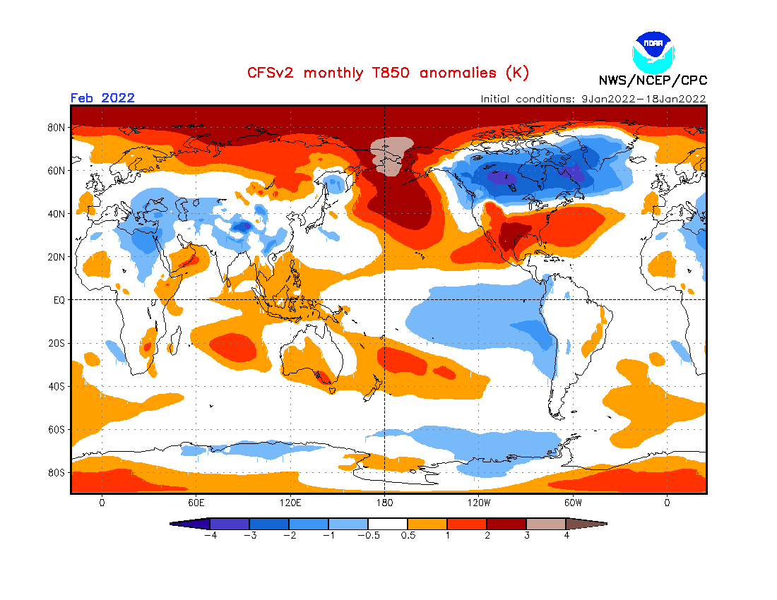
The southern and central United States looks to be mainly warmer than normal, while the northwest and the Midwest will see cold outbreaks. But such a weather pattern also supports the cold outbreaks extending into the central and eastern United States, as we have seen this winter before.
Over Europe, the high pressure over the west will bring warmer than normal temperatures into the region. But it also supports a cooler northwesterly flow into parts of central and southeastern Europe.
GLOBAL OCEANS AND SEASONAL WEATHER
One of the main large-scale drivers this cold season has been the La Nina event in the tropical Pacific Ocean.
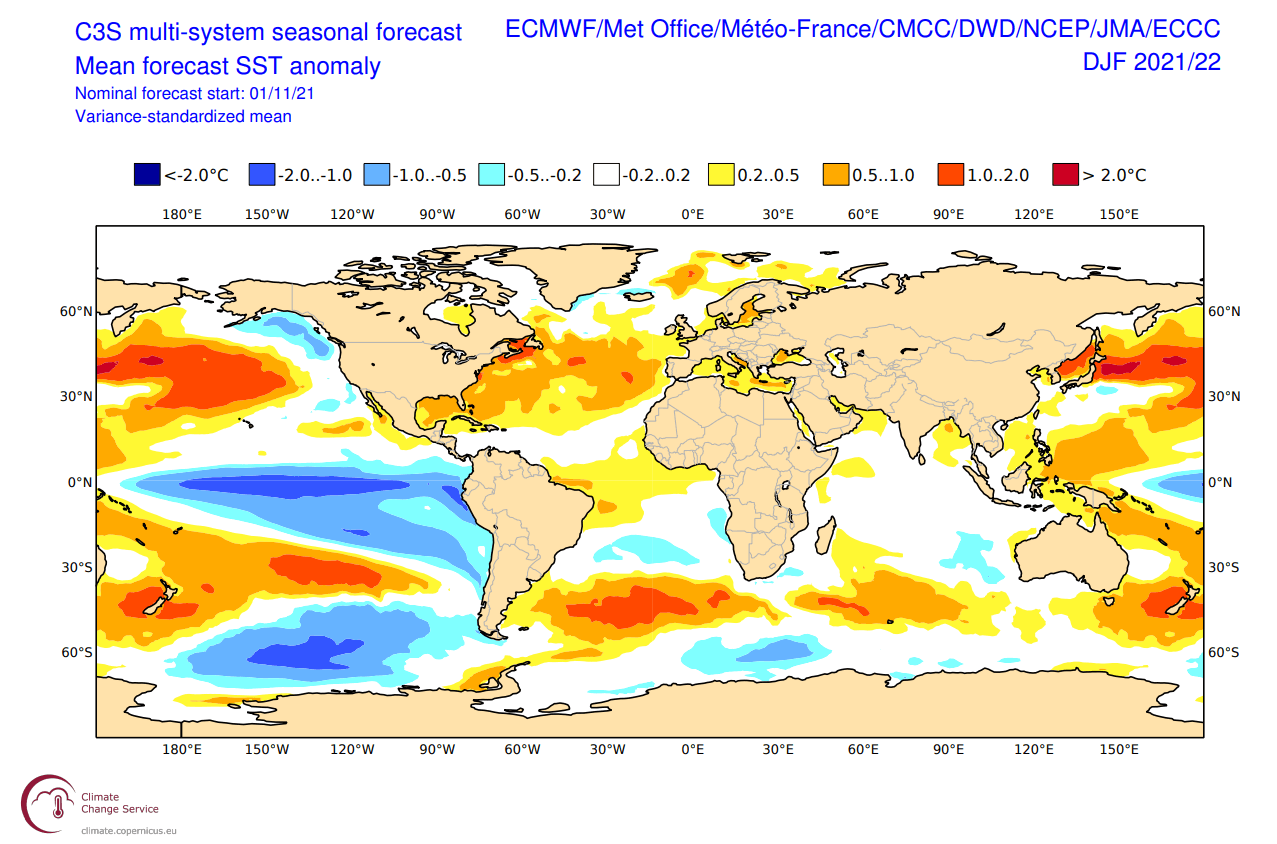
On the image below you can see the latest global ocean temperature anomaly. Notice the colder than normal surface waters in the tropical Pacific regions. That is a mature La Nina event, spanning far across the equatorial Pacific Ocean, powered by the trade winds.
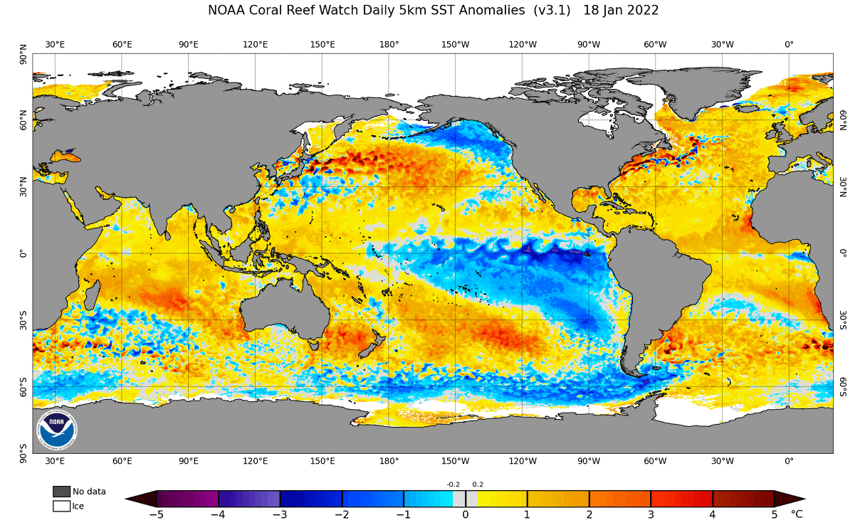
The presence of a cold La Nina is the key feature in weather development since late Fall and will continue into Spring.
A La Nina is actually just a different name for cold ocean temperatures in the tropical Pacific ocean. The actual ocean-atmosphere system is called ENSO.
Keeping it simple, ENSO is short for “El Niño Southern Oscillation”. This is a region in the tropical Pacific Ocean, which alternates between cold and warm phases.
The tropical trade winds (winds that circle the Earth near the equator) usually initiate or stop a certain phase, as they mix the ocean surface and alter the ocean currents.
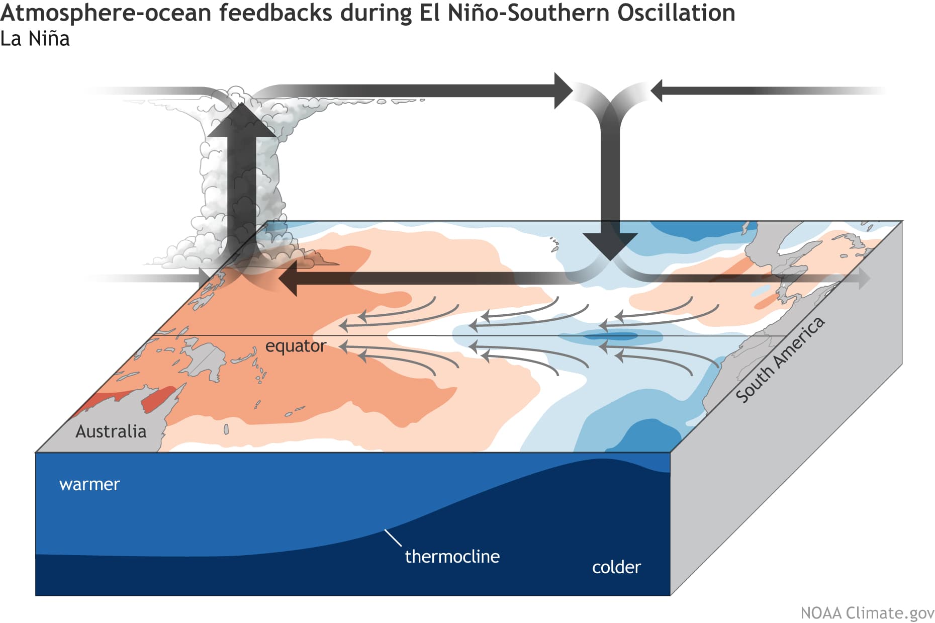
Om the image below from NOAA Climate, you can see a typical circulation pattern during a cold ENSO ocean event. Air descends in the eastern Pacific, creating stable and dry weather conditions. In contrast, air rises in the western Pacific, causing lower pressure, frequent thunderstorms, and a lot of rainfall in the western Pacific.
ENSO has a major impact on the tropical convection patterns and thus on the ocean-atmosphere system. Through this delicate system, it distributes its influence globally.
We usually observe a global shift in pressure patterns during the emergence of the ENSO phases, each having a unique impact on the weather globally.
A specific phase (warm/cold) usually develops around late summer/early fall and can last until next summer, or even up to two years in some cases.
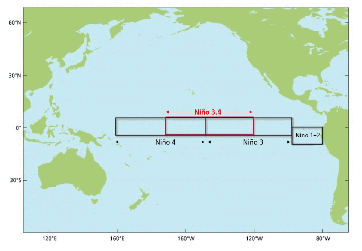
The cold phase is called La Nina and the warm phase is called El Nino. Each ENSO phase is determined by the temperature anomalies (warmer/colder) in the ENSO 3.4 region in the tropical Pacific, as seen on the image below.
The best way to visualize a development of a cold ocean phase is with a high-resolution animation over time.
In the video below, you can see cold ocean anomalies emerging in the tropical Pacific around July. Notice the “waveforms” across the region, as the surface waters are being pushed west by the trade winds.
The image below is an analysis and forecast image from multiple North American long-range models. It shows the La Nina from last year weakening in spring and a new one emerging this Fall.
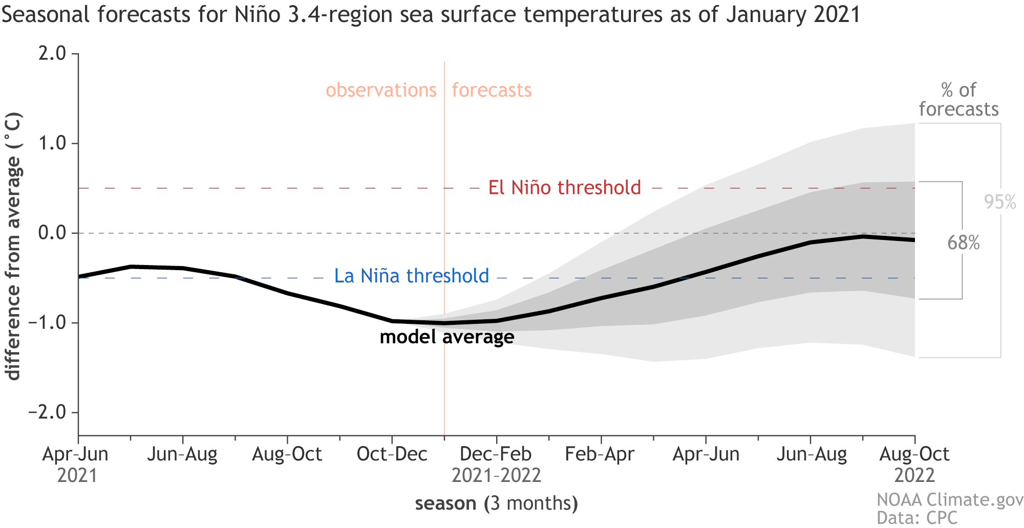
The forecast for the first half of 2022 shows the cold phase is already at the coldest in the winter season. Quickly weakening in the next months, its influence will still reach deep into spring 2022
Below we have the ocean temperature forecast for the Spring season from multiple global long-range models. It shows a quite weakened cold ocean phase in the equatorial Pacific Ocean.
It has a weak presence in the ocean, but a still strong influence in the atmosphere, as we will see in the forecast part of the article below.
WEATHER AND THE JET STREAM
Typically, the first influence of these ocean anomalies can be seen on the changing jet stream. The jet stream is a large and powerful stream of air (wind) at around 8-11km (5-7mi) altitude.
It flows in a west-to-east motion around the entire Northern Hemisphere, affecting pressure systems, and their strength, shaping our weather on the surface.
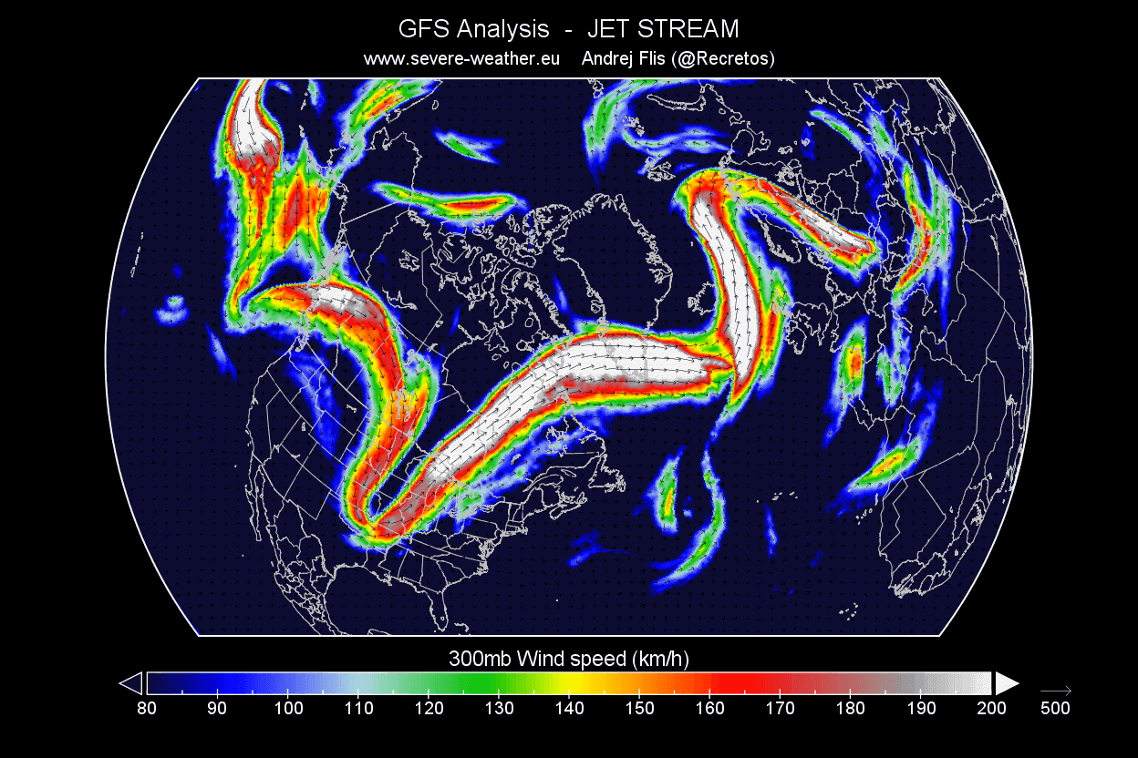
Below is an example of the jet stream in winter at the 300mb level (9km/5.6mi altitude). In this example, the jet stream is quite deformed down over the central United States, which brings colder air down from the north.
It bends upwards over northwestern Europe. Such formation brings colder weather to the eastern United States and stormy weather to Iceland and the British Isles.
Historically, the most typical effect of a cold ENSO phase is a strong blocking high-pressure system in the North Pacific. The image below shows the average pattern during the last few winters with a cold tropical Pacific ocean event.
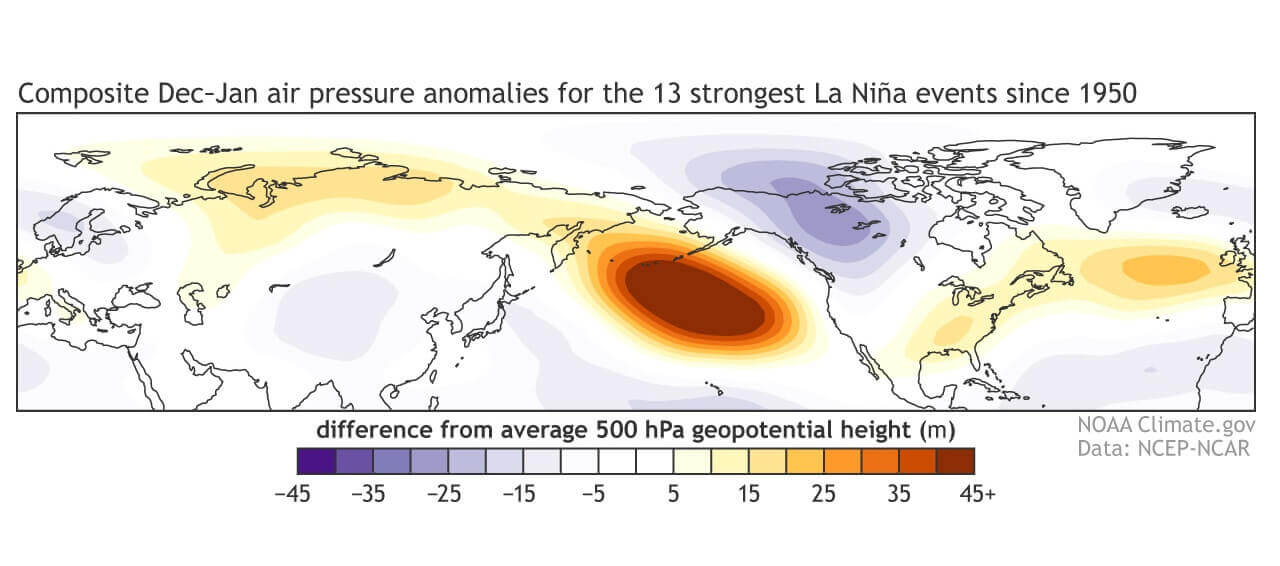
We can see the strong high-pressure system in the North Pacific and a low-pressure area over Canada and southwestern Europe. Europe is quite tricky to define the ENSO influence, as the Atlantic also plays a major role here.
The circulation of the strong high-pressure system promotes the development of a low-pressure region over Alaska and western Canada. It curves the jet stream downwards in-between the two pressure systems. That is exactly the weather pattern that we are seeing this winter so far.
You can see the average position of the jet stream during La Nina winters on the image below, and the resulting weather patterns over the United States and Canada.

The shifting jet stream brings colder temperatures and storms down from the north into northern and the northwestern United States, creating warmer and drier weather in the southern and the eastern states
This way, the jet stream can actually divide the United States into 2 weather poles. In the northern part of the country, colder and wetter events are more frequent, as the jet stream directions the storm systems and cold weather there.
But that can somewhat lockout the southern United States, as it creates warmer and more stable weather with less frequent storms and cold fronts.
After passing Canada and the United States, the polar jet stream moves out into the North Atlantic. This is where La Nina perhaps loses its direct influence over Europe, as regional weather systems in the Atlantic play a heavy role.
It usually still has an important influence, because it changes the position of the jet stream entering the North Atlantic. The jet stream can merge with the systems in the Atlantic, helping to create a whole new weather pattern for Europe.
The problem is that the final outcome is far more unpredictable in this region compared to North America, which feels a much more direct weather influence.
SPRING 2022 – FIRST SEASONAL FORECAST
We now know what La Nina is, and how it can change the jet stream and our weather. Now we will take a look at the global long-range models, and how they see the upcoming Spring 2022 season.
As per ususal, we decided to focus on the 3 main (or most used) seasonal models. The ECMWF and UKMO from Europe, and the CFSv2 from the United States. Graphics are from the Copernicus Climate EU project and the CPC/NCEP.
All these forecasts show an average picture over the course of 3 meteorological spring months (March-April-May) and show the prevailing weather patterns. Even if the models would be completely accurate, it does not mean that such weather conditions would last for 3 months straight. It only suggests how the weather patterns might look 40-60% of the time.
ECMWF SPRING SEASON FORECAST
The ECMWF model is most often referred to as the most reliable model, at least in the long-range category. In reality, a lot depends on the individual years/seasons. But generally, the ECMWF model is at the top of the chart as far as reliability goes.
But no long-range/seasonal forecast can ever be deemed “reliable“, as we are only looking at trends and how the weather patterns are evolving on a large scale and longer time periods.
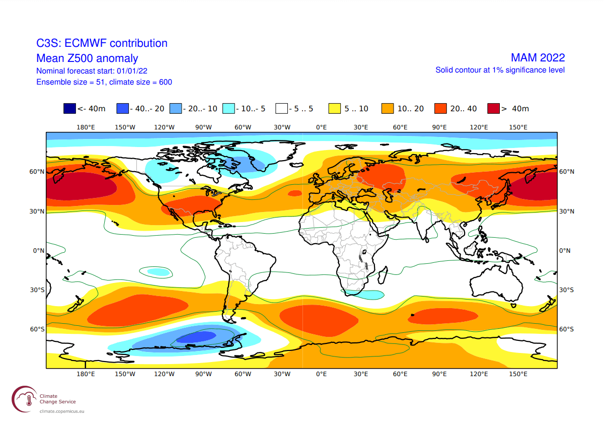
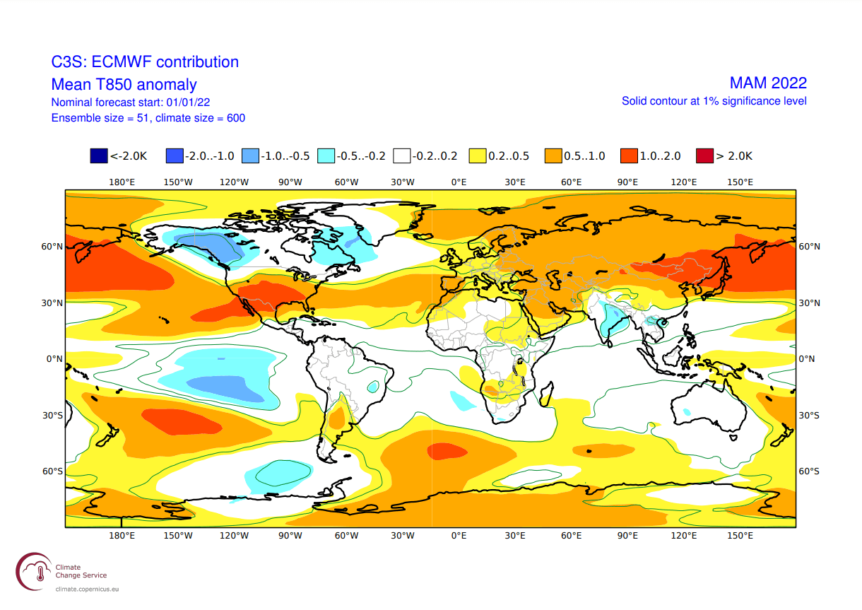
In the pressure pattern forecast from ECMWF below, we can see the typical La Nina high-pressure system in the North Pacific. The low-pressure system is present over western Canada and the Greenland area. The jet stream is bending in between the high and low-pressure systems as we have seen in the previous segment.
We also see the North Atlantic in a positive North Atlantic Oscillation (NAO) mode, which means an amplified jet stream over the British Isles and into Scandinavia. This is a positive NAO setup, tho a weaker one. A positive NAO generally means mild/warmer conditions for Europe and the southeastern United States.
The airmass temperature forecast below shows North America divided into two parts. Western Canada is forecast to be colder than normal. Thanks to the jet stream, there is a high chance of the colder air extending south, into the parts of the northern United States, over the Midwest into the northeastern United States. The Southern United States is forecast to be warmer than normal.
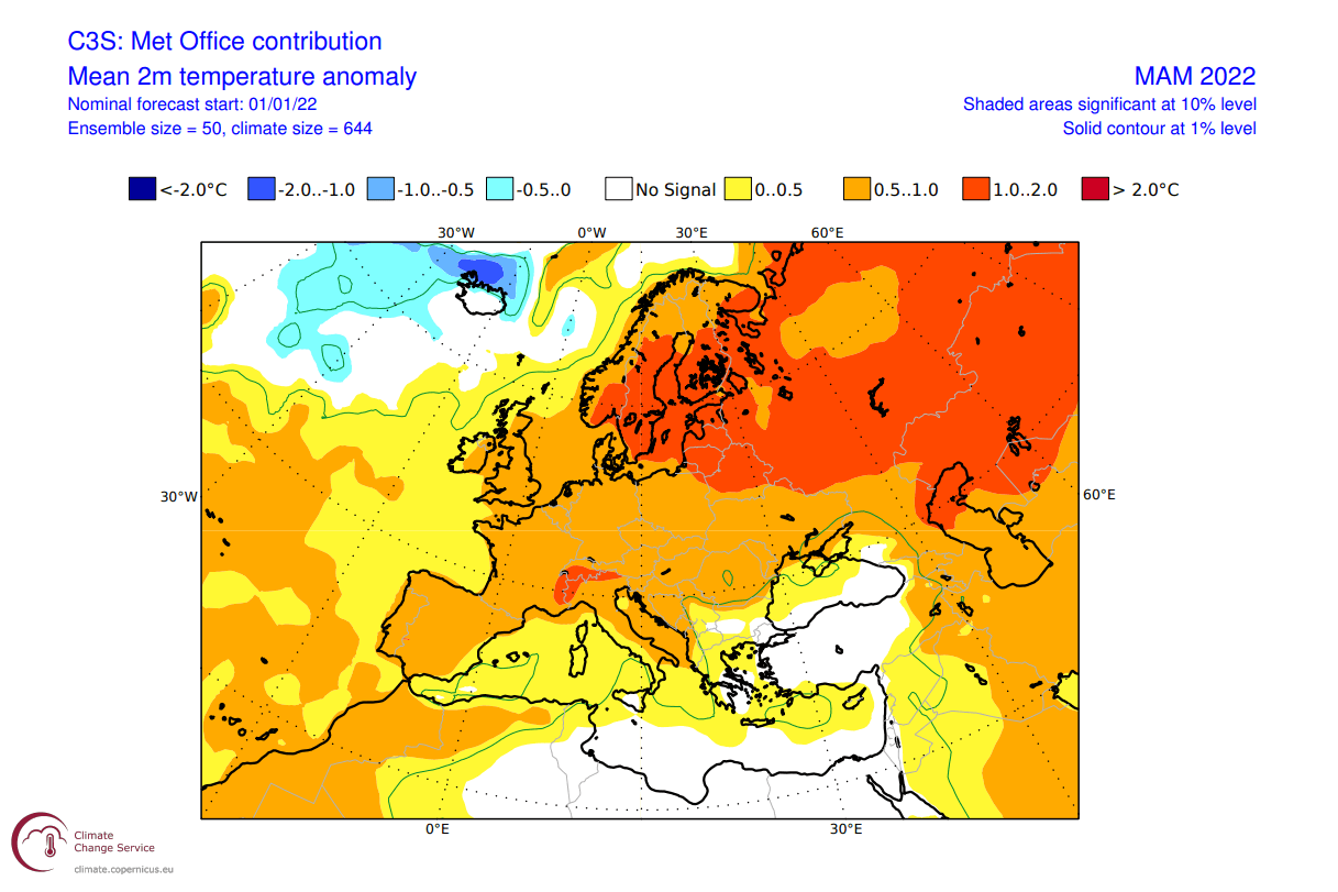
Europe also features higher than normal temperatures. A more westerly flow dominant scenario is suggested, but the pressure pattern does allow for a break in the flow. Occasional cold flow from northwest Europe is possible down into the central regions.
Looking closer at Europe, we see the surface temperatures are mostly above normal. Warmer temperature anomalies and milder conditions are more likely towards the eastern regions. Central and western regions are likely to see occasional cold fronts from the northwest, with occasional pattern swings.

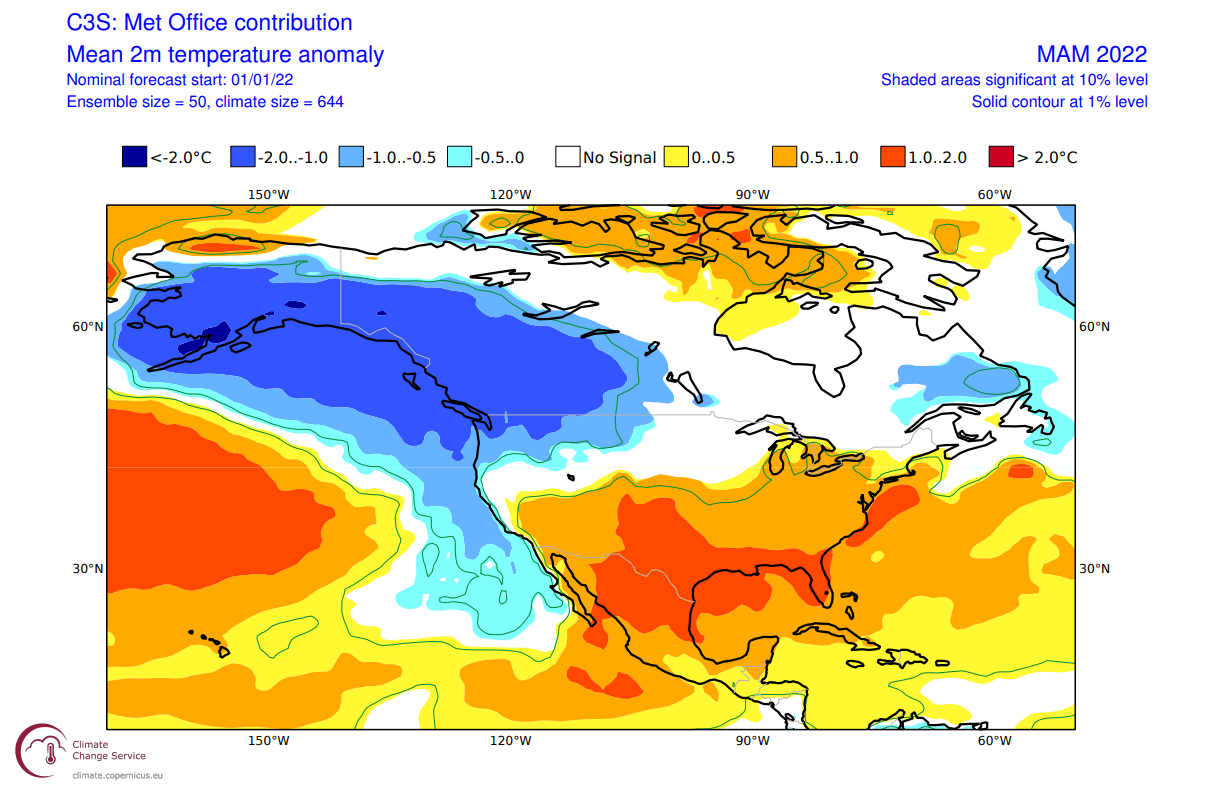
Over Noth America, the ECMWF forecast shows colder than normal surface temperatures over much of Alaska and western Canada. We do see an indication of colder air intruding into the northwestern United States and the Midwest. Warmer than normal temperatures are forecast for the southern regions.

Despite being shown warmer than normal, the central and northeastern parts of the United States tend to get occasional colder weather and snow in early spring, during these jet stream patterns.
The precipitation anomaly forecast below shows a more normal La Nina type pattern over Canada and the United States. We see the mainland United States with wetter conditions in the northwest and the east, and drier conditions in the southwest and over Florida.
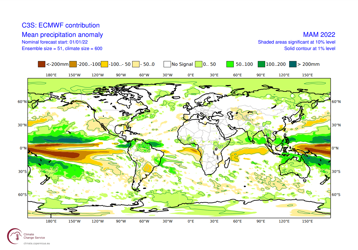
Europe is trending to have more precipitation over the northern regions, where most of the low-pressure systems can be found. Drier conditions are forecast for western Europe, under the high-pressure system.
UKMO SPRING SEASON FORECAST
Our second model of choice is the UKMO model, from the official United Kingdom Met-Office. This has also been a good performer in the past years, so we tend to include it in our standard “package” of early model forecasts.
UKMO has a slightly different pattern than the ECMWF, as one would expect at this range. It shows the strong La Nina blocking high-pressure in the Pacific. But it has a stronger Canadian low-pressure zone, and also a stronger low-pressure area in the North Atlantic. This can also be due to the lower ensemble spread in the model.
This is a much stronger positive NAO pattern, creating an amplified jet stream into northern Europe and a more durable high-pressure zone over Europe.
The temperature forecast however still looks similar to the ECMWF. Over North America we have the cold pool over western Canada and Alaska, reaching down into the northwestern United States. The southern and eastern United States is forecast to be warmer than normal by the UKMO model.
Europe features mostly warmer than normal conditions, with a storm track further up over northern Europe.
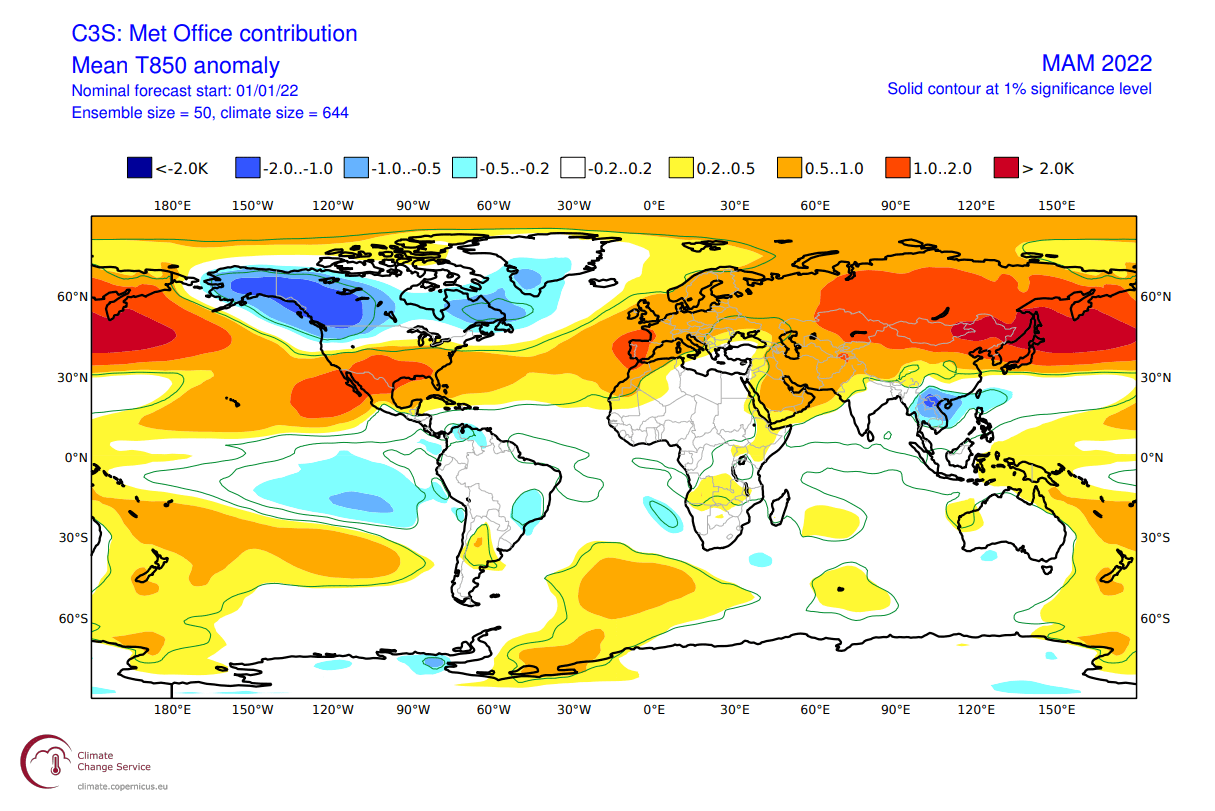
Looking closer at Europe, we see the stronger warm anomalies focused over central and northeastern regions. The pattern that UKMO suggests leaves little room for cold air intrusions. But we have seen cold air outbreaks every spring. What usually changes each year is the number of these outbreaks.
Over North America, we see the double weather pole. Cold up north in western Canada, and warmer down in the United States. The exception is the northwestern United States and the Midwest, which shows an extension of colder than normal temperatures. That is likely the pathway for cold air spills down from Canada down into the eastern United States as well.
The precipitation forecast also nicely shows the drier conditions over the southwestern United States. Northern and eastern parts of the United States have a higher chance of wetter conditions under the jet stream. Europe features higher precipitation over northern regions, due to the higher frequency of storms moving over this area.
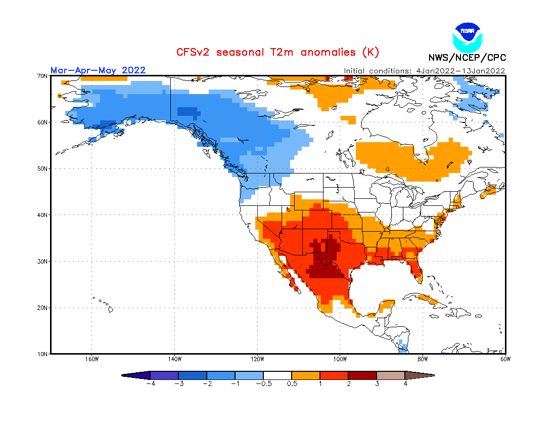
CFSv2 SPRING SEASON FORECAST
In contrast to the European models, we tend to use the main North American long-range model, the CFS version 2 from the NOAA/NCEP in the United States.
The CFS model is closer to the ECMWF, with the strong high-pressure system in the Pacific and the separated low-pressure system over western Canada and the North Atlantic. This creates a pressure/temperature difference between Canada and the southern United States, putting the jet stream over the northern United States.
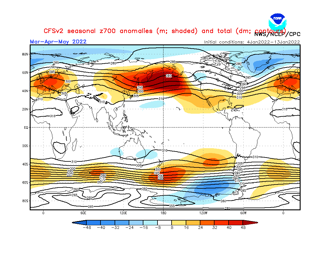
The jet stream in the North Atlantic bends northeastward, over the British Isles and Scandinavia. This is a typical positive NAO pattern, with warmer than normal weather over Europe.
Airmass temperatures are most interesting over North America, with a cold air anomaly in western Canada and warmer air in the southern United States. Europe is seen warmer than normal, as expected with storms moving far out in northern Europe, locking out the colder air for most of the time.

Looking closer at Europe, the surface temperatures are really warmer than normal over much of the continent, especially northern regions. This is very similar to the other two seasonal models presented above and seems to be a consolidated (high-reliability) forecast at this point.

The North American forecast below shows a dipole temperature pattern. Colder than normal temperatures remain over western Canada and the northwest United States.
Warmer than normal weather prevails over the southern parts of the United States. There is a gap in the warm anomaly, indicating a likely path of spring cold over the Midwest into the northeastern United States.
Global precipitation forecast again shows drier than normal conditions over the southwestern United States. Northwestern and eastern United States is likely to have more precipitation than normal, due to the jet stream moving over these parts.

In Europe, we see mostly drier conditions across central, western and southern regions. Wetter conditions are forecast for northern Europe, where the main storm track is prevails.
SPRING EARLY FORECAST – SUMMARY
As reading images and descriptions can be confusing sometimes, we have put together a simple Spring 2022 forecast summary:
Europe is expected to have mostly warmer than average temperatures over much of the continent. This, however, does not mean that there will be no cold fronts and colder days. It just implies that cold fronts and colder air mass intrusions will be less frequent over the region.
The models are close in agreement over the pattern in the North Atlantic. The main difference is the strength of the low-pressure over Iceland/Greenland. An average picture from all three models suggests lower pressure in this region, limiting the cold air intrusions into the continent.
Normal to wetter conditions are expected over northern Europe. The British Isles and Scandinavia could have a more unsettled spring, as the jet stream positions over these regions, bringing along stormy weather. Mainland Europe is expected to experience normal to drier spring, with drier trends more towards western Europe.
North America spring forecast looks fairly solid to be a typical winter extension. Most of western and Central Canada is to expect colder and snowier conditions, along with Alaska.
The Northern United States is expected to have normal-to-colder spring winter with more precipitation. This increases the chance of spring snowfall events. But that is more likely in the northwestern region and in the Midwest, with the lesser degree into the northeastern United States.
The Southern United States has a high chance for warmer and mostly drier than normal spring weather. This however does not imply that no cold front can reach the southern states. It just implies that in a La Nina pattern, it is much less likely to get frequent cold fronts down to the very south.
The main channel of spring cold air outbreaks seems to be from the northwestern United States and the Midwest down into the central and eastern United States. Similar to what we are witnessing this winter so far.
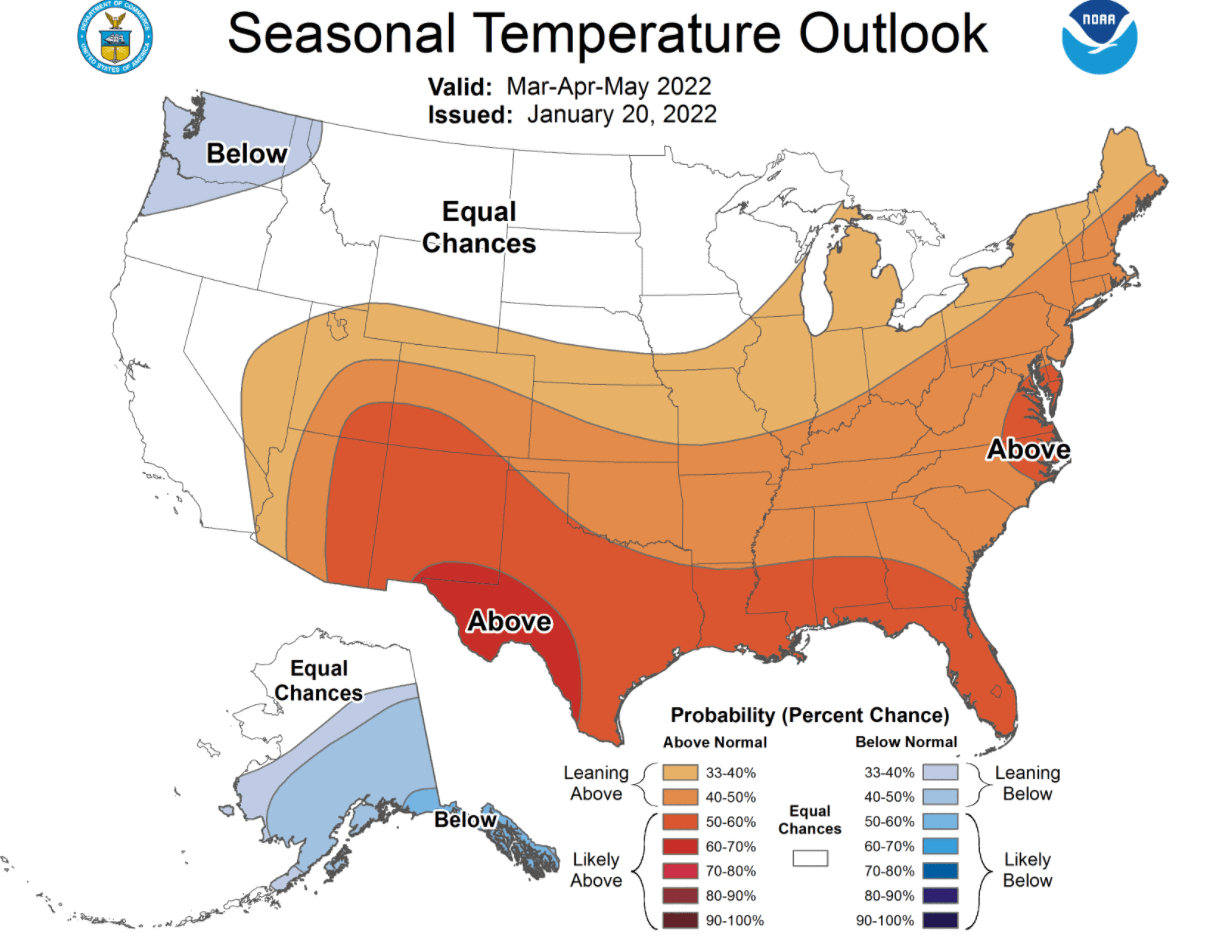
Below is the official Spring temperature forecast for the United States by NOAA. It shows the temperature probability, with colder to equal chances in the northern United States. The southern half of the country and the northeast have a higher probability of warmer than normal weather, as seen in the models above.
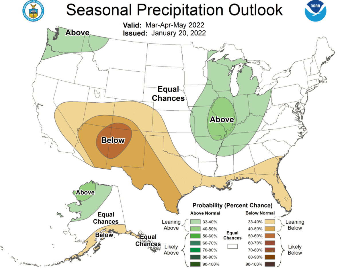
The official precipitation forecast is also quite similar to the model forecast. We see an equal-to-higher probability for more precipitation in the northwestern and the easter United States. The southern United States is forecast to have a drier than normal spring season, especially in the southwest.
The problem with precipitation in any La Nina season is usually the persistence of drought conditions in the south and southwest. Below we have the latest drought graphic from NOAA, which shows the current drought conditions in the United States.
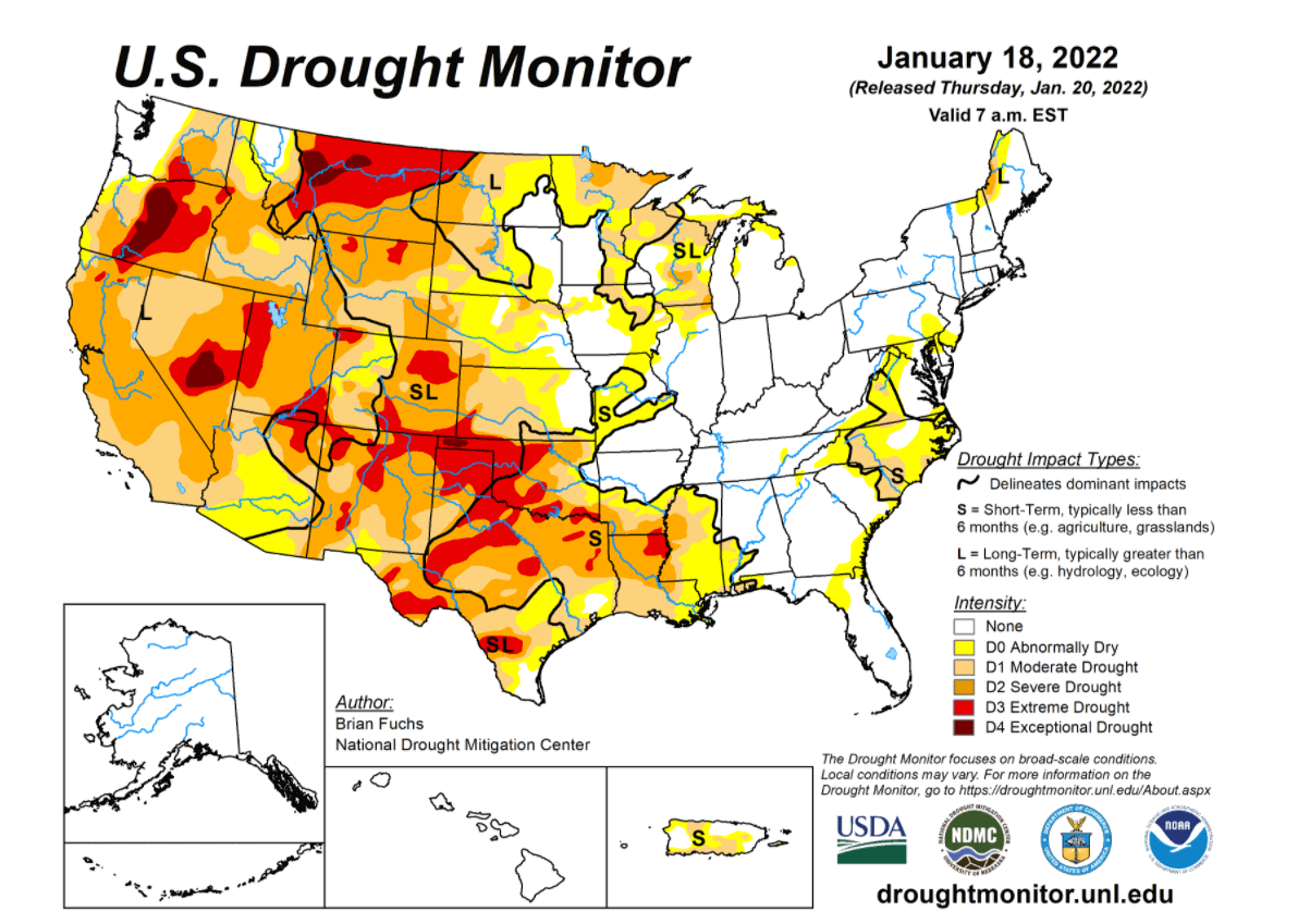
Most of the western United States is under some level of drought conditions. The driest conditions prevail in the south-central states and in the northwestern United States. Most of the eastern half of the country is currently not affected by severe drought conditions.
Spring generally means that warmer temperatures are returning. But with warmer temperatures, the severe weather season also returns to the United States. We will finish off this article by looking at the typical historical severe weather patterns in a La Nina Spring.
We will include a more detailed look at the severe weather season when more forecast data is available in the forecast update next month.
2022 USA SEVERE WEATHER SEASON
As history shows, La Nina can also have a profound influence on the Spring tornado season in the United States. And usually not in a good way.
Below we have a very interesting image from NOAA Climate. It shows a frequency of hailstorms and tornado events during the spring season in the United States, between El Nino and La Nina years.
It is quite interesting to see, that in a La Nina spring season, there is a substantially higher frequency of hailstorms and tornado events. The highest frequency is found in the southern and southeastern parts of the United States.
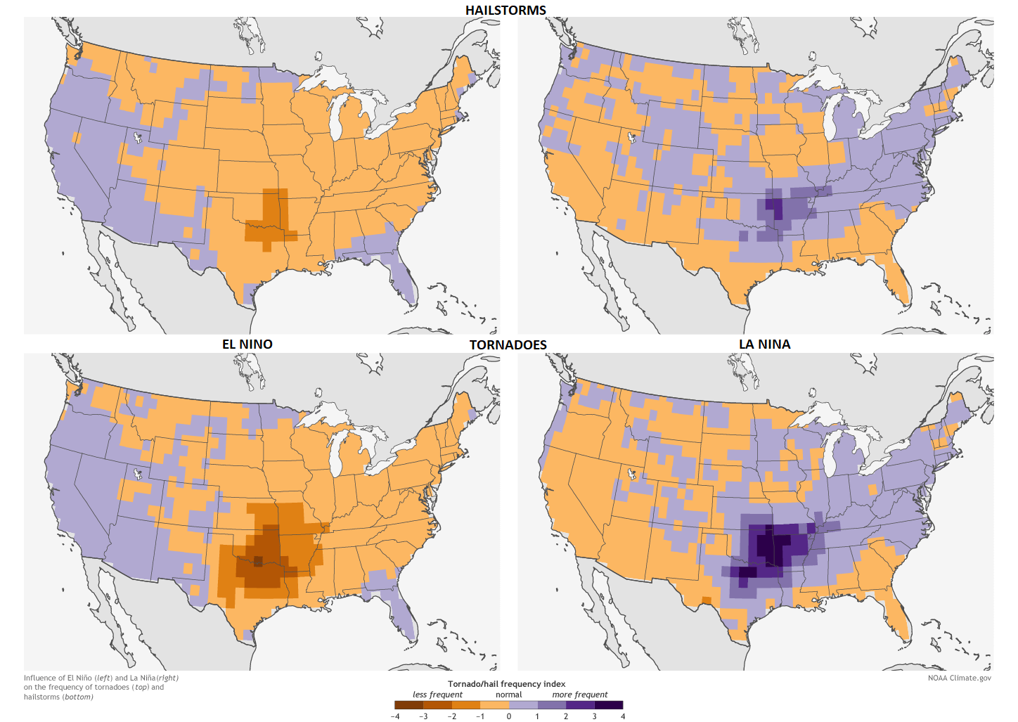
This nicely outlines the Tornado Alley. This is a nickname given to an area in the southern plains of the central United States that consistently experiences a high frequency of tornadoes and other severe weather events each year.
But why are there more tornadoes and other severe weather in the southern United States during a La Nina?
A lot has to do with the weather pattern we have seen earlier during a typical La Nina season, promoting a high-pressure system in the North Pacific. That typically corresponds to the pressure drop over western Canada and the northwestern United States.
This can act as a source region for frequent cold fronts, which move from western Canada down towards the south-central United States. There the cold front meets warm moist air coming up from the Gulf of Mexico.
Thanks to the shifted jet stream, this produces a very volatile combination with a lot of available thermal and wind energy for the storms to become severe and tornadic.
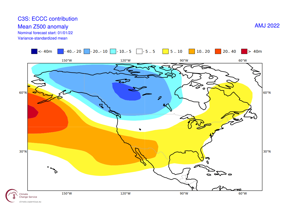
The image below shows the April-May-June pressure forecast from ECCC. We can see the lower pressure over western Canada, extending down into the northwestern United States. This sustains the cold pool in western Canada, fueling frequent cold fronts in spring.
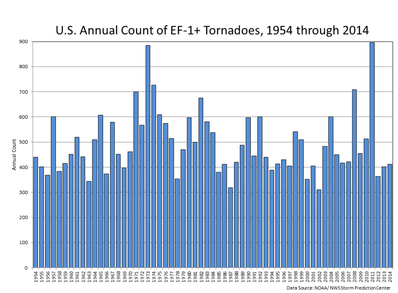
Below is also a graph that shows annual tornado numbers in the United States from 1954 to 2014. Looking at the years, we can see that from the top 5 most active tornado years, 4 were La Nina years.
We will keep you updated on the developing weather trends in the coming seasons, so make sure to bookmark our page. Also, if you have seen this article in the Google App (Discover) feed, click the like button (♥) there to see more of our forecasts and our latest articles on weather and nature in general.
Don’t miss: