Convection initiation typically starts along boundary-layer convergence zones. These zones have long been known to be key factors in convection initiation and further storm evolution. The boundaries that trigger convection could be cold fronts, gust fronts, sea-breeze fronts, drylines, or pre-existing boundaries, e.g., outflow boundaries from storms earlier.
Initiation of convection
On a warm day, convection begins when the air close to the surface warms enough to become buoyant and start rising. This process is called free convection. The temperature at which free convection begins is called the convective temperature.
When the convective temperature is reached on a clear, hot, and humid day, the atmosphere becomes widespread, and explosive development of thunderstorms begins. The height at which the rising air condenses moisture is called the convective condensation level (CCL).
Air parcels at the surface buoyantly lift and require no other mechanisms to start lifting. There are different ways of getting air parcels at the surface to begin lifting, even if the air near the surface is stable (below convective temperature).
There needs to be another lifting mechanism that pushes the air to a height where it becomes buoyant and begins to rise. The height at which the rising air condenses moisture is now called the lifted condensation level (LCL).
Triggers of convection – cold and warm front
A typical way of forcing air parcels upwards is along a boundary, such as a cold or warm front. A cold front effectively bulldozes the warm air ahead of it, pushing it upwards.
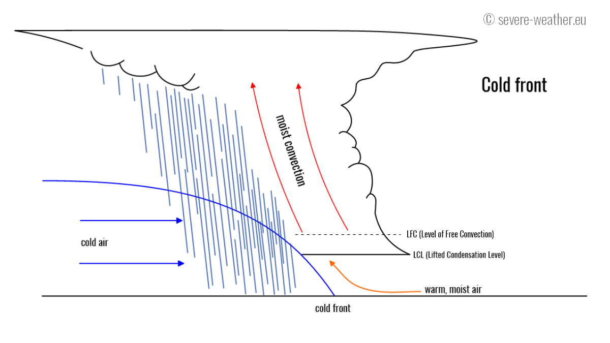
The case is reversed along a warm front: the warmer (less dense) air is forced over the wedge of cold air, which is slowly pushed forward by the warm air. The cold front can be a significant (synoptic) scale front of the boundary of cool air flowing out of a pre-existing thunderstorm (outflow boundary).
On a warm front, warm air pushes on the colder air ahead of it. As the warm, moist air is more buoyant than cold air, it is pushed up and over the chilly air. The cold air forms a wedge, slowly pushed away by the warm air. More often than not, a warm front produces relatively shallow convection and mostly moderate rain showers. In some cases, thunderstorms also form on the warm front.
Interesting fact: in Tornado Alley, thunderstorms on warm fronts are prolific producers of tornadoes.
Dryline convergence
There is a third, much more rare type of front, called a dryline. Along with this type of front, air temperature does not change much, but humidity (air moisture content) changes a lot. Drylines form near mountain ranges and, under the right conditions, also initiate convection.
Other types of convection triggers
The convergence of surface winds may also lead to the initiation of convection. The air in the convergence zone is forced upwards. The convergence zone also acts as a frontal boundary if two air masses have significantly different temperatures and humidities.
Additionally, convergence zones are typically areas of substantial moisture pooling; increased moisture increases convective instability, lowering the lifted condensation level and, consequently, the level of free convection.
Another way of initiating convection is orographic lift: air moves horizontally over flat terrain but is forced upwards when it encounters higher terrain (hills, mountains).
Another mechanism can assist in initiating convection without a convergence of surface winds or orographic lift. Upper-level forcing happens when winds at high altitudes (5-10 km) diverge, i.e., the airflow fans out. This creates an area of low pressure, which encourages vertical motion, which in turn helps moist, warm air rise before reaching convective temperature.
Recap: When warm, moist air near the ground is heated by the Sun, it may become warm enough to start lifting convectively. The temperature at which this process begins is called convective temperature. If this temperature is not reached, convection will not start.
Other processes may help the air rise and convection begin, even if the convective temperature is not reached. These processes are known as forcing. Forcing mechanisms include fronts (warm front, cold front), outflow boundaries (small-scale cold fronts produced by individual thunderstorms), surface wind convergences, orographic lift, and upper-level forcing.
Measures of convective instability
There are many different kinds of measures of convective instability. The most common, and you will come across in virtually an in-depth forecast or storm chaser discussions, is CAPE = Convective Available Potential Energy. CAPE is fuel for convection – and thunderstorms.
CAPE is the energy a parcel of air has for upward motion. The higher the CAPE, the faster and higher the air parcel can rise. CAPE depends on the temperature and amount of moisture (humidity) in the air near the ground and the vertical temperature gradient. The higher the CAPE, the hotter and more humid the air on the ground. Also, the faster the temperature drops with height, the higher the CAPE.
You will likely come across several variations of CAPE: SBCAPE, MUCAPE, and MLCAPE.
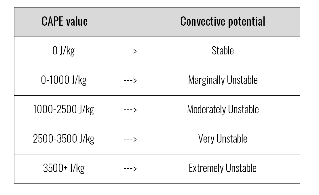
Fun fact(s): The rising air goes up fast under the right conditions! While most thunderstorms form moderately unstable conditions (CAPE up to ~1000 J/kg), in some cases, much more energy is available. This is called extreme instability, where CAPE values can reach several 1000s J/kg or more in such cases.
CAPE value – Convective potential
When thunderstorms form in this type of environment, the upward speed of rising air is extreme, sometimes over 150 m/s! This is enough to keep hailstones 15+ cm in diameter airborne!
Here is an example of convective initiation on the visible satellite video from Oklahoma in May 2016: https://www.youtube.com/watch?v=MczgvGLI9LI
Related topics: