This is an update of the ongoing dangerous winter storm moving across the Midwest and towards the Northeast United States where a lot of snow is expected by Sunday evening. Heavy lake-effect snow will develop east of Erie and Ontario Lakes. The system pushes a significantly colder air mass into the Southeast United States and Florida this weekend.
A dangerous winter moving across the Midwest of the United States this Friday has left behind widespread wind damage across the northern Rockies and the north-central Great Plains as we discussed on Wednesday. The strongest winds were observed in Montana, up to 125 mph in the mountains (Mount Sentinel).
The storm spread a damaging windstorm from the Northwest states across Idaho, Montana, Wyoming, and Utah with numerous reports of power outages and more than 700.000 customers left without power. Widespread downed trees were reported as well.
As reported by the NWS in Glasgow, Montana, the official weather station recorded a 79 mph wind gust at Glasgow airport and setting a record-breaking January wind event for the city. The previous record was 72 mph, set in 2009.
National Weather Service (NWS) has now issued winter storm warnings and advisories ahead of the approaching large winter storm, moving towards the Northeast and southeastern Canada by Sunday evening and will produce light snow over parts of the Midwest through Sunday evening.
As the associated cold front moves eastward, the rain will move into the Lower Great Lakes and especially along the Mid-Atlantic and New England Coast.
There will be heavy lake-effect snow developing downwind from the Lakes Erie and Ontario and into the Northern Green and White Mountains of New Hampshire and Vermont. The greatest amount of snow is expected across the Tug Hill Plateau, with nearly 20 inches possible. The snow will produce hazardous driving conditions.
To the south and west of the winter storm, a significant cold outbreak spread into the Southeast United States, including the northeast Gulf Coast and Florida. Attached below is the video animation of the storm’s evolution this weekend. Much colder air mass spreads into the Gulf, while winter storm with lots of snow hits the Northeast.
As the storm strengthens through Friday night, a swath of heavy snow will develop from New York into northern New England and southern Quebec. Fo the south of this corridor, heavy to locally very heavy rain is forecast, including the cities of Washington, D.C., Baltimore, and Boston on Saturday.
WINTER STORM HEADS TOWARDS THE NORTHEAST
This Friday evening, a winter storm has grown very large, dominating the eastern half of the United States, centered above the state of Illinois. A frontal system is extending across the Great Lakes, with the cold front moving into the Mid-Atlantic Region. Its large core is pushing a very cold air mass towards the Southeast.
Notice there is also a well-defined windstorm across the Oklahoma and Texas Panhandle, with blowing dust with severe northwesterly winds.
As the initial area of low pressure weakens, a second low is a forecast to develop along the leading cold front and track north from along the northern Mid Atlantic coast into the Northeast on late Saturday.
While the upper wave will be gradually losing its strength towards the end of the weekend, the surface low will re-strengthen as it moves into the Northeast United States and New England. It will become quite large and deepen its central pressure below 990 mbar. Centered over New England on Saturday evening, covering the whole Northeast and the East Coast.
The system is forecast to gradually track to the east, with areas of rain and snow moving across the Ohio and Tennessee valleys into the eastern United States on Saturday.
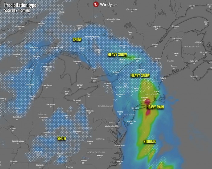
By Saturday morning, the frontal system will eject the Great Lakes, extending south across the northeast Mid-Atlantic coast with heavy rain across Long Island, Connecticut, and Massachusets. Further north, heavy snow will be ongoing across northern New Hampshire and northern New York state, as well as further north into Southern Ontario, Canada.
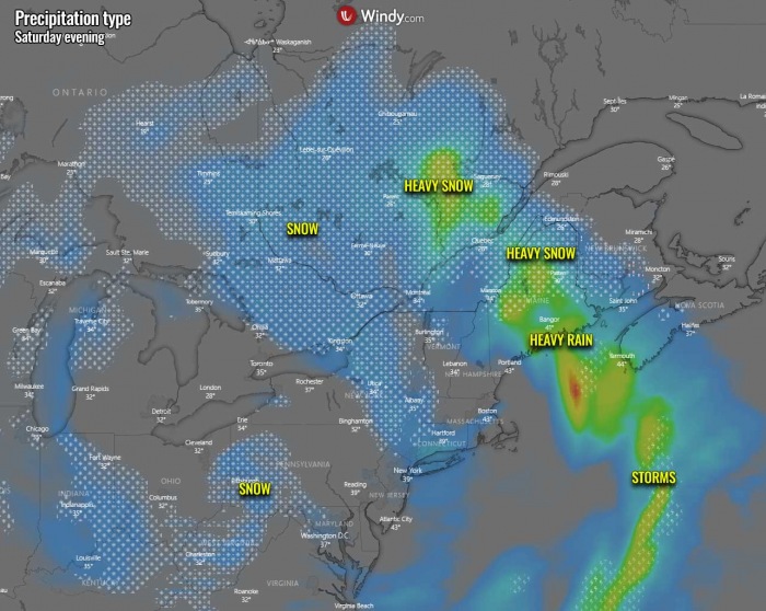
As the surface low deepens over the Northeast, heavy rain spreads further east across New England. Including southern Maine through late Saturday. Heavy snow develops across northern Maine, as well as southern Quebec with favorable moisture advection into the region. Blizzard conditions are expected with strong winds to the north of the surface low in these areas.
As the low peaks through Saturday night into Sunday morning, very heavy rain spreads across Nova Scotia with local flooding possible. Very heavy snow with high snowfall rates is expected across northern New Brunswick. Snow continues to spread across portions of southern Quebec.
Severe blowing snow will introduce hazardous driving conditions and snowdrifts could lead to roadblocks in some places. Whiteout conditions are likely to develop.
The total snow accumulation with the winter storm this weekend will bring a few inches of snow across Illinois, Indiana, and Ohio Valley by Sunday morning. Much more snow is expected across portions of the New York, Vermont, New Hampshire, and Maine states, associated with the deepening surface low towards New England.
Localized snow peaks are seen across northern Michigan, and western New York. These areas will receive a good amount of lake-effect snow.
WINTER STORM WARNING is in effect from 7 am Saturday until 7 am Sunday for Northern Oxford, Northern Franklin, and Central Somerset Counties in Maine. Heavy snow expected with total snow accumulations of 5 to 12 inches expected. Winds gusting as high as 35 mph. Travel could be very difficult.
The highest snowfall totals of a foot or more are expected over peaks and ridges. Slushy, wet accumulations are expected for valleys. Power outages are possible due to the wet and heavy nature of snowfall along with gusty winds during the afternoon and evening.
A FOOT OF LAKE-EFFECT SNOW FOR TUG HILL PLATEAU
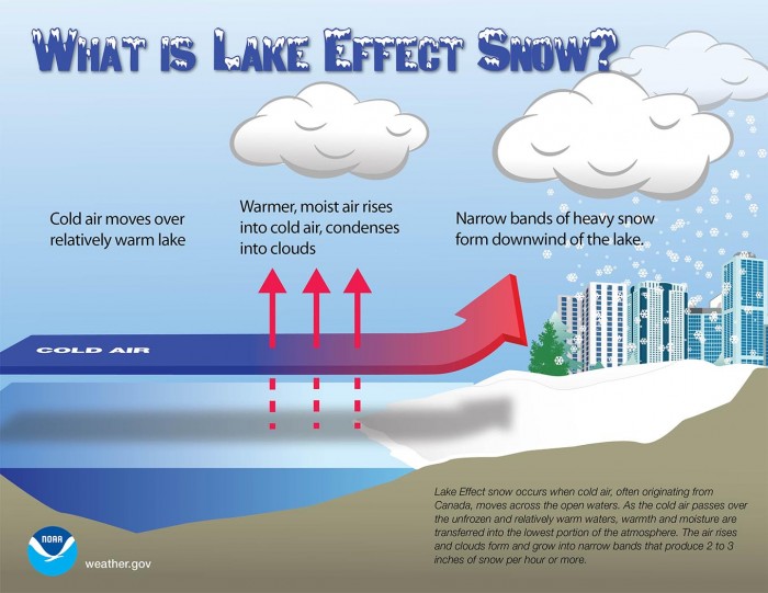
A quite typical occurrence, lake-effect snow, is expected to develop in the wake of the winter storm. The lake-effect snow is common across the Great Lakes region during the late fall and winter. It occurs when cold air, often originating from Canada, moves across the open waters of the Great Lakes.
As the cold air moves over the unfrozen and still relatively warm waters of the Great Lakes, warmth and moisture are transferred into the lowest portion of the atmosphere. The air rises, clouds form and grow into a narrow band that produces heavy snow bands with 3-5 inches of snowfall rates.
The key component is the wind direction which determines which areas will receive lake-effect snow. Heavy snow typically occurs in very narrow bands and squalls, so it may be falling in one location, while the sun may be shining just a mile or two away in either direction.
While the core of the winter storm ejects the Great Lakes region by early Sunday, the system introduces the lake-effect snow through the day into the night hours. It is likely that 10-20 inches of snow could accumulate along the east-southeast shores of Lake Erie and Ontario.
However, the overall position of the low and the winds in its wake will not be particularly favorable for the greatest snow this time. But some local hot spots could indeed see a foot of fresh snow.
WINTER STORM WARNING is in effect from 1 am Saturday until 7 pm Sunday over the Eastern Lake Ontario Region. Heavy snow expected with total snow accumulations of 15 to 20 inches across the higher terrain of the Tug Hill Plateau. With Total accumulations of 4 to 7 inches across the lower elevations.
Winds gusting as high as 35 mph on Sunday will result in some blowing and drifting snow. The greater snow amounts will be confined to the higher terrain of the Tug Hill Plateau. Travels will be very difficult at times with poor visibility and snow-covered roads, especially across the higher terrain of the Tug Hill Plateau.
COLD OUTBREAK INTO THE SOUTHEAST UNITED STATES
While the winter storm and its main frontal system continue spreading across the Midwest and Great Lakes tonight, it continues towards the Northeast United States on Saturday into Sunday. The parent upper-level core will be strengthening while drifting towards the East Coast over the weekend.
Thanks to upper-level High across Canada, the core will be moving towards the Southeast United States over the weekend. Introducing northerly winds towards the far south and bring very cold air mass across the deep South of the United States over the weekend. Including the Gulf Coast, Florida, and most of the Gulf of Mexico as well through Sunday.
Significantly lower than normal temperatures are forecast, with even more than 10 °C colder temperatures spread across the Southeast and the Central/Eastern Gulf Coast on Saturday. These temperatures will likely bring below-freezing temperatures and frosty Sunday morning from Mississippi across Alabama into Georgia and parts of northern Florida.
WHAT’S NEXT FOR THE END OF JANUARY?
We were talking about some similarities of this winter’s pattern with the famous January 1929 extreme cold period. The winter that year was one of the coldest in the past century.
And what weather models are trending, we could see similar temperature distribution across the United States by the end of this month. The attached chart hints at extreme cold to develop across western Canada and northern/northwestern United States.
The first pockets of the extreme Arctic cold air mass could arrive around the next weekend, January 22-24th, based on the global weather models GFS and ECMWF. Temperatures could drop much lower than normal, even near 20 degrees below. Then another wave of Arctic cold arrives around the 27th.
The reason behind this is the powerful upper-level ridge and a surface high-pressure system building up in the Pacific, connecting with other high-pressure systems over the polar region. Similar as it happened during the winter weather pattern back in January 1929.
Trends towards the final days of January suggest that the colder air could also expand further towards the Midwest, central and eastern United States.
Over the United States and western Canada, the temperatures can get very low, which is revealed by the very strong negative anomalies in the forecast, indicating unusually cold temperatures could spread from Canada into the northern United States.
Regarding the snow forecast by the ensemble models, a substantial increase of snow coverage is likely over Canada and the northwestern United States until the end of the month.
The extreme cold over these areas could also extend into the first week of February, as further trends have some hints that the northern and Northwestern United States with western Canada remains under a favorable pattern position. More on this soon.


