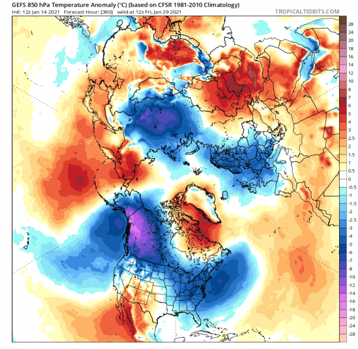
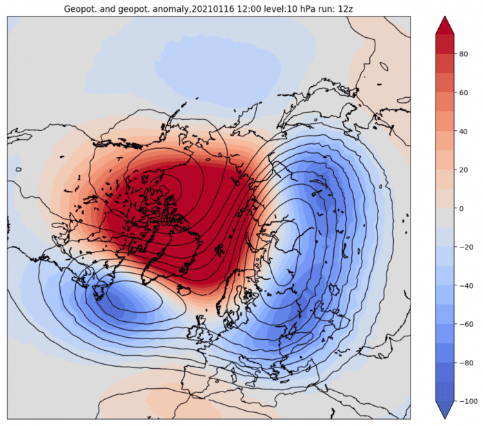
The Winter weather pattern forecasts for the second half of January 2021, now show a startling similarity to January 1929. That was one of the coldest winters in the past century. Almost an identical temperature distribution is setting up across the United States and also Eurasia.
A key role in this winter weather pattern change belongs to the Polar Vortex, or rather to its collapse. A strong exchange of energy has disrupted the stratospheric polar vortex, with the disrupted flow now starting to influence our weather.
First, we will quickly learn what exactly is the Polar Vortex, as we tend to explain this in most of our winter forecast articles. Knowledge is essential and powerful, so why not learn something new in just mere seconds.
WINTER WEATHER AND POLAR VORTEX
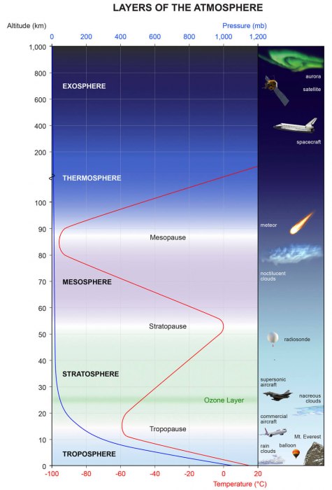
All of the clouds (and the weather that we feel) are found in the lowest part of the atmosphere called the troposphere. It reaches up to around 8 km (5 miles) altitude over the polar regions and up to around 14-16 km (9-10 miles) over the tropics.
Above it, there is a much deeper layer called the stratosphere. This layer is around 30 km thick and is very dry. This is where the famous Ozone layer can be found. We can see the layers of the atmosphere on the image below, with the stratosphere in green hues, and the troposphere in blue at the bottom.
Every year as we head into autumn, the north pole starts to cool. But the atmosphere further south is still relatively warm as it is still receiving energy from the Sun, while the polar regions receive much less over time.
The reduction in temperature also means a gradual pressure drop over the north pole. In the stratosphere, the process is the same. As the temperature drops over the pole and the temperature difference towards the south increases, a large low-pressure (cyclonic) area starts to develop across the stratosphere.
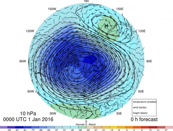
The image below shows a typical example of the Polar Vortex at around 30km altitude (10mb level) in the middle stratosphere.
It is almost like a very large cyclone, covering the whole north pole, down to the mid-latitudes. The polar vortex is present at all levels, almost from the ground up. The image below shows the polar vortex at different altitudes. The closer to the ground we get (left side), the more deformed it gets, due to the complex terrain and the many weather fronts and systems.
We produced a high-resolution video for you below, which very nicely shows the Polar Vortex spinning over the Northern Hemisphere. It covers the period from December 2020 to January 2021, made from NASA GEOS-5 data.
Video shows the 10mb level (30km altitude) potential vorticity parameter, which overly simplified means, that it shows the energy of the polar vortex. Be aware of how the energy is being drained from the polar vortex by the large, strong (and rather invisible) high-pressure systems spanning from North Pacific over the pole into Siberia.
POLAR VORTEX BREAKDOWN
Usually, we look at the polar vortex in the stratosphere at the 10mb level. That is around 28-32km (17-20 miles) altitude. This altitude is considered to be in the middle stratosphere and is thus a good representation of the general dynamics of the polar vortex.
The strength of the polar vortex is most often measured by the power of the winds inside it. Usually, this is done is by measuring the zonal (west to east) wind speeds around the polar circle (60°N latitude).
Below we have an analysis from the NASA monitoring system, where we can see a very interesting progression.
In early December, the polar vortex was at a quite strong level, reaching 40m/s zonal wind speeds. Towards mid-month, and especially towards late December, the polar vortex began to weaken.
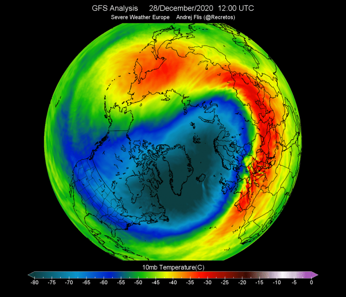
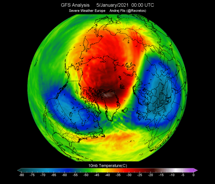
In late December, a warming sequence began in the stratosphere, from Europe over into central Asia. It was starting to engulf the outside layers of the polar vortex. The cold-core of the polar vortex was still rather intact at this point, holding temperatures colder than -80°C in the center over Greenland.
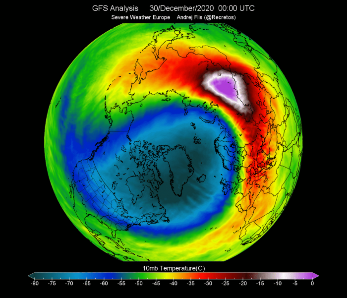
Just two days later, the warming wave reached a local peak over Siberia, with maximum temperatures in the wave reaching up to +5°C or higher.
On January 5th, the preliminary date of the Sudden Stratospheric Warming event was marked, as the winds around the polar circle have reversed.
The stratospheric warming wave has crawled over the entire North Pole in the stratosphere, effectively splitting the cold-core of the polar vortex into two parts.
One has moved over North America and one over the European sector. At this point, this does not have much to do directly with the winter weather on the surface, as this is at 30km altitude. But we will now slowly move onto the weather effects.
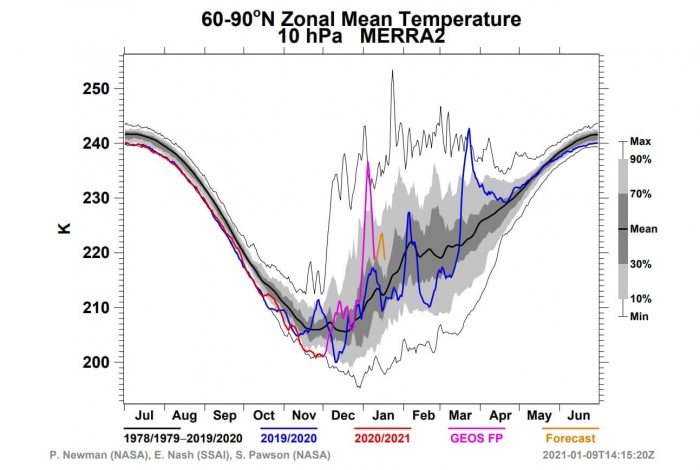
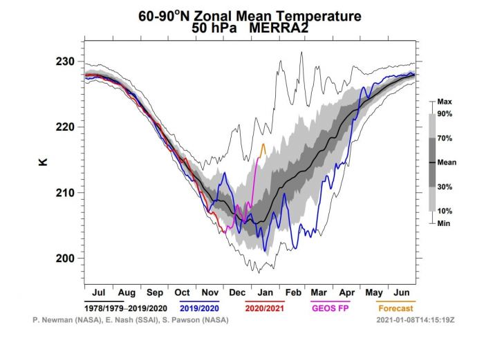
Taking a look at the NASA temperature analysis for the stratosphere, we can see the large temperature spike at the 10mb (30km) level, which is in the middle stratosphere. The second image shows the temperature analysis in the lower stratosphere at 50mb (20km) level, also having a very clear temperature spike.
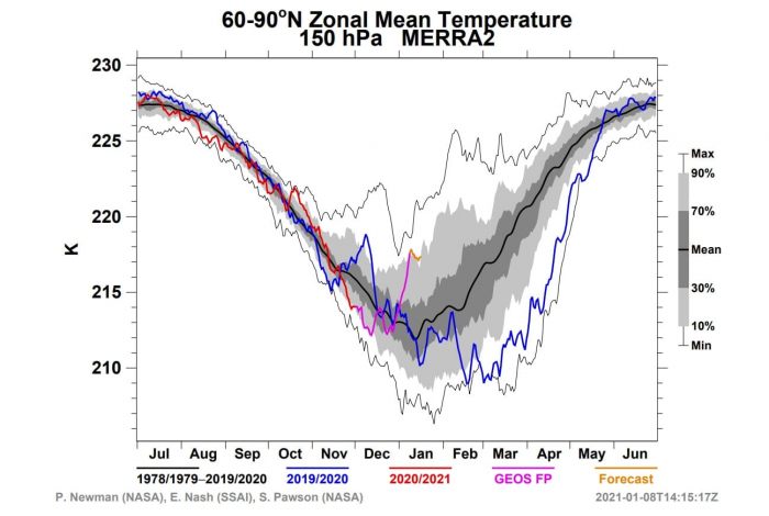
Even lower is the 150mb level (13km alt), which is somewhat of a boundary or the “buffer zone” between the stratosphere and the troposphere. Here we can also see the temperature spike, meaning the warming event was fairly robust and fast and reached down to the lower levels, bordering the weather itself.
When trying to find a connection between the stratosphere and our winter weather, it helps to have more specialized graphics at hand. One such is the altitude versus time type.
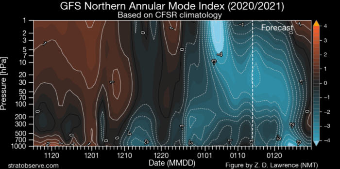
The image below shows an atmospheric oscillation index. Negative values indicate higher pressure and positive values indicate lower pressure. We have altitude from the ground up to the top of the stratosphere and time.
We have strong negative values in the stratosphere in early January, associated with the higher pressure onset and the stratospheric warming event. We can see that this event and/or its influence is slowly descending over time, reaching the lower levels by mid and late January.
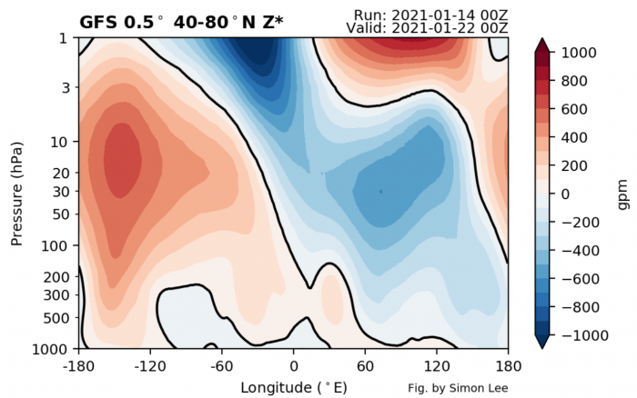
Looking at a single day in late January, we can see the pressure anomalies with altitude around the North Hemisphere. There is a very obvious connection from the high pressure in the stratosphere down towards -120° to -180° longitude, which is in the North Pacific sector.
There is also an arm towards 0° to -60°, which is around the Greenland area. We can also see lower pressure (blue) connecting down from the stratosphere towards 60-120-180 longitude, which is in the Siberian sector.
WINTER WEATHER – HISTORY REPEATS
History can sometimes be the best teacher for the future, and especially in weather, this can be true more often than not.
One of the coldest winters of the past century was the Winter of 1928/1929. It was especially cold in late January and February, with temperatures reaching down to -30°C in central Europe.
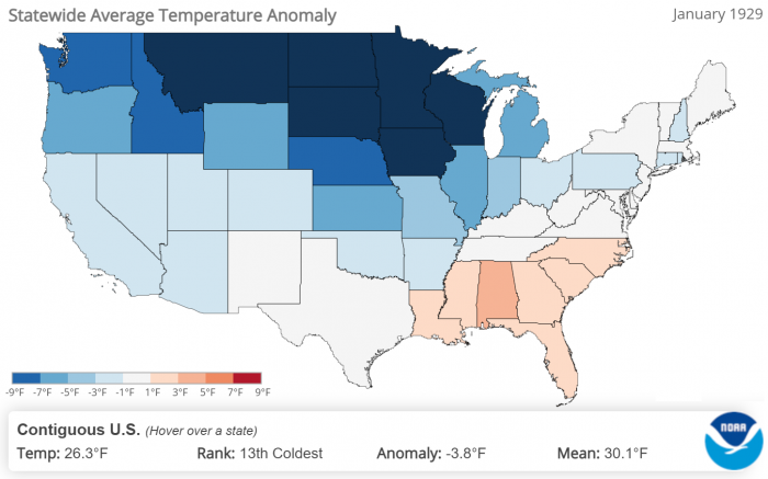
In the United States, January 1929 was also very cold, especially in the northern states. The image below is from NOAA/NCEI and shows the temperature anomalies by states in January 1929.
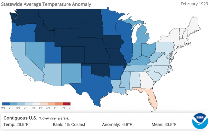
February 1929 was even more extreme, with the cold extending towards the south, into central parts. Nation-wide this was the 4th coldest February in the past 126 years.
We will look at some weather anomalies across the Northern Hemisphere in January 1929, comparing them to current forecasts for January 2021.
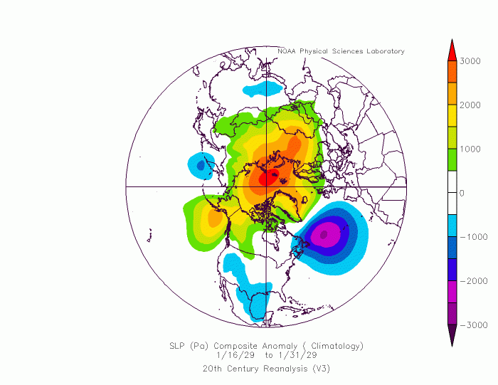
First, we have the geopotential height pattern for the second half of January 1929. We can see the dominating high-pressure systems over the completely blocked Polar regions. Low-pressure systems were present over the western United States, Europe, and the northwestern North Atlatnic.
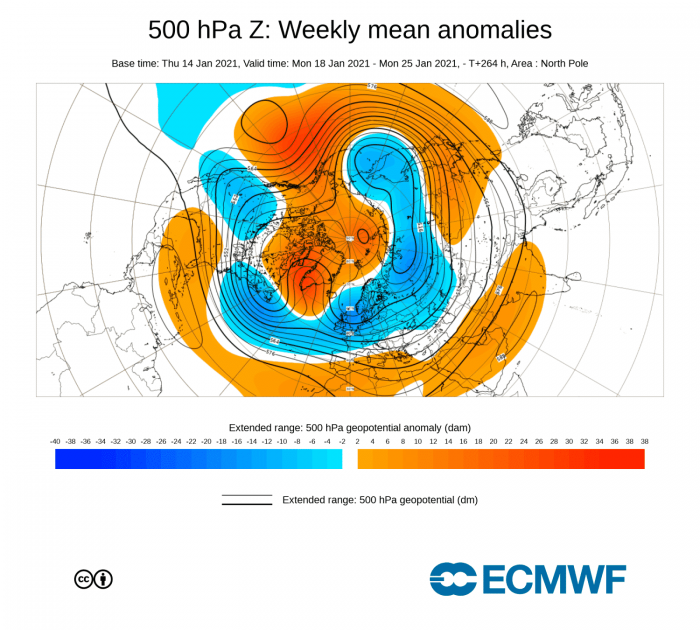
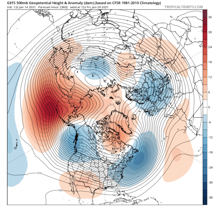
Below we have the late January pressure anomalies from the ECMWF forecast. It shows an extremely similar winter weather pattern to 1929. We have high-pressure dominating the polar regions, with low-pressure areas in the western United States, western North Atlantic, and Europe into Siberia.
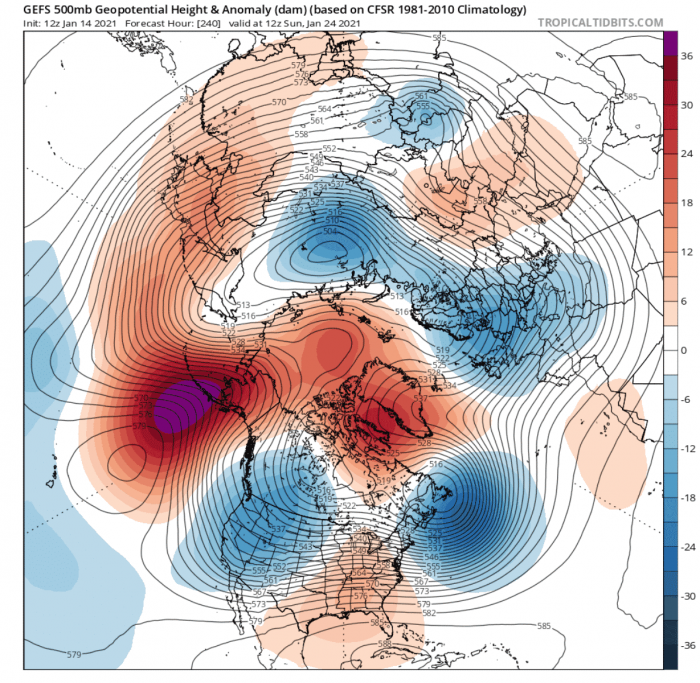
Looking more closely at individual days, we can see that in around 10 days, the winter weather pattern is a copy of January 1929. A powerful high-pressure system is building in the Pacific, connecting with other high-pressure systems over the pole. low-pressure systems are also in strikingly similar areas.
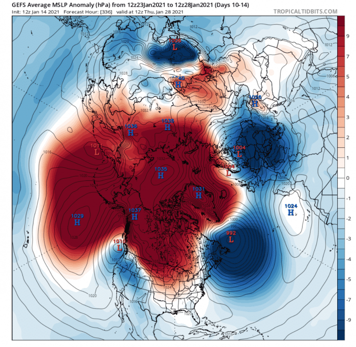
Sea level pressure anomaly is also featuring a very strong Polar High-pressure system complex, with a dominating low-pressure system in the western North Atlantic.
The Actual 2021 sea level pressure forecast shows the same pattern, with blocked polar regions and low-pressure areas from the western Noth Atlantic and Europe.
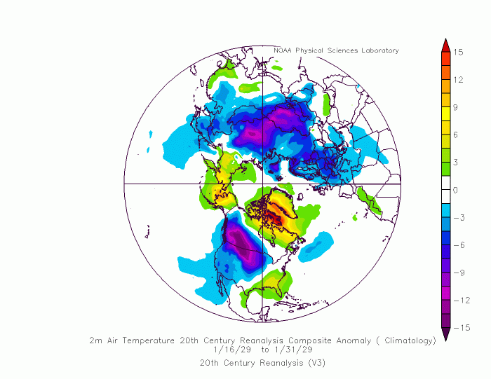
The temperature analysis for the second half of January 1929 reveals a very cold area from western Canada into the northern United States. We also have strong cold anomalies over Europe and central Asia.
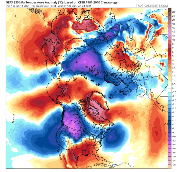
In 2021, the day 10 temperature forecast shows a very similar temperature pattern. We can see an unusually strong cold anomaly setting up over western Canada and the northwest United States, and also over Europe and central Asia.
Snow forecast from the GEFS ensemble system shows a substantial increase over Canada and the northwestern United States in the day 6-10 forecast range. There is a temporary snow depth reduction in this time period over Europe, while snow depth increases over Scandinavia.
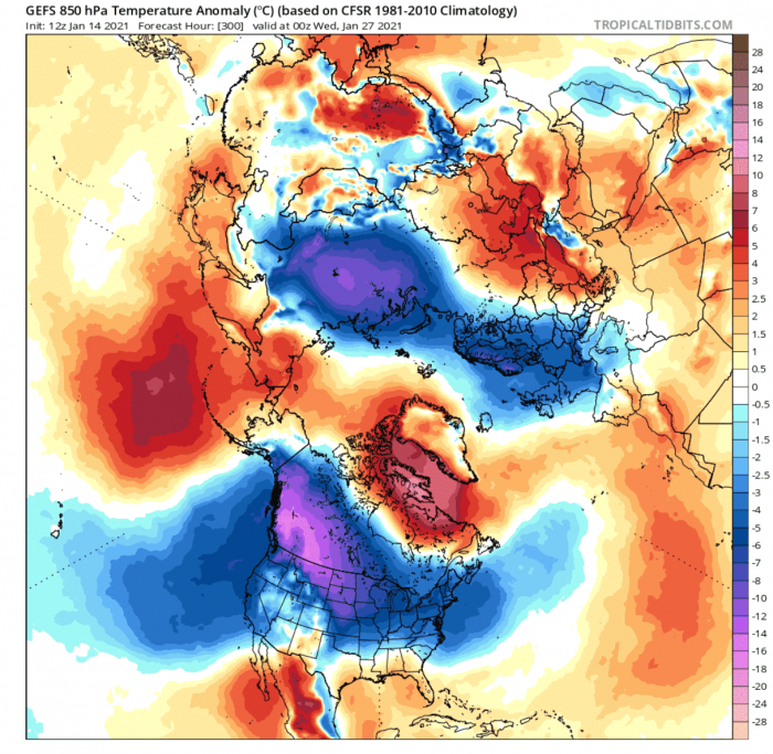
Going deeper into late January, the colder air expands from western Canada into Northwestern United states and further towards the Midwest and central and eastern United States. Europe also awaits another round of colder air, with the active cold air transport from the Siberian Arctic sector.
By the end of the month, the weather pattern will still hold, featuring the strong North Pacific high-pressure system. We have seen in an earlier image, how this Pacific ridge has linkage to the polar vortex breakdown.
At the same time, we can see the temperature anomalies also being consistent. The unusually cold air is still present over western Canada. We don’t see strong negative anomalies over the continental United States, but colder air transport is indicated and supported by the pressure pattern. Cold air remains over Europe at this point, but the actual strength of the negative anomalies is reducing.
Cold air remains over Europe at this point, but the actual strength of the negative anomalies is reducing. This could be due to the simple ensemble spread increase in the forecast. The main core of the colder air is trending more towards Scandinavia and central Europe.
The day 10 to 15 snow depth change shows further snow depth increase over Canada and especially over the northwestern and the northeastern United States. There is also a substantial snow cover expansion over Europe, as a result of the colder air intrusion(s).
All in all, the winter weather pattern for the second half of January 2021 looks very similar to January 1929. Altho we do not know yet with high confidence, just how cold it will actually get, we do know that colder air is on the way, especially for western Canada and the northern and eastern United States. Europe is also set to receive a new round of colder air in late January, with an associated snow cover expansion.
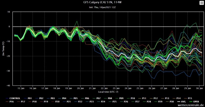
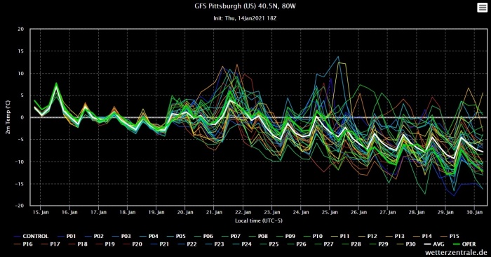
The temperature forecast from the GEFS ensemble system below, shows the cooling trends for 3 cities across North America.
First, we have the temperature forecast for Calgary, in Canada, which shows a strong intrusion of colder air. The second image is for Great Falls in Montana, USA, also revealing a temperature drop. The third is for Pittsburgh in Pennsylvania, indicating a cooling trend also for the northeastern United States.
But it is not by coincidence that the 1929 and 2021 winter weather patterns are so similar. Just like this year, there was also a likely stratospheric warming event in January 1929, breaking apart the polar vortex.
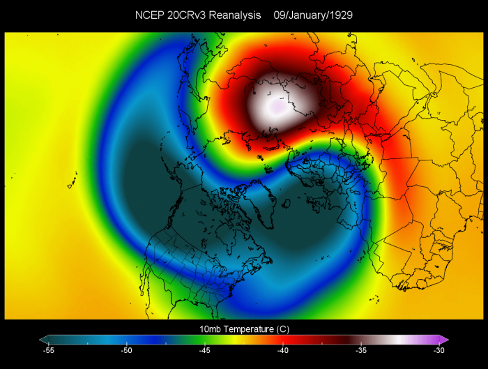
We do not have actual observations of the 1929 polar vortex, but we do have modelled reanalysis (20cr V3), which does show the high likelihood of a stratospheric warming event in early January 1929.
The image below shows the 10mb temperature in early January 1929. We can see a warming event pushing in from the Siberian sector, just like we have witnessed it this winter season.
Looking at the geopotential heigh, we can see a high-pressure area in the stratosphere (10mb – 30km alt), pushing against the polar vortex, breaking it apart in the second week of January 1929.
As a comparison, we have the current 30mb (23km alt) geopotential height, which shows exactly the same story as in 1929. A high-pressure system pushing against the polar vortex, breaking it apart.
This strongly implies that the cold air outbreaks over the northern United States and especially over Europe likely had a strong connection to a Polar Vortex breakdown event like we have witnessed this winter season.
The actual temperatures in Europe likely won’t go as far down as in 1929. But the cold air will spread over the region, showing that similar events can sometimes produce similar results. The source regions are currently not as cold as in 1929, but the temperatures will still drop quite a few degrees below normal.
Over the United States and western Canada, the temperatures can get very low, which is revealed by the very strong negative anomalies in the forecast, indicating unusually cold temperatures could spread from Canada into the northern United States.
Looking quickly at the February 1929 temperature anomalies below, we can see that an even colder month has followed. Over central and eastern Europe, many all-time February cold records were set, which still holds today.
We will keep you updated as fresh data is available, and more reliable forecasts are released for February 2021. So stay tuned, and don’t forget to bookmark our page to have all the info at hand!
SEE ALSO:
