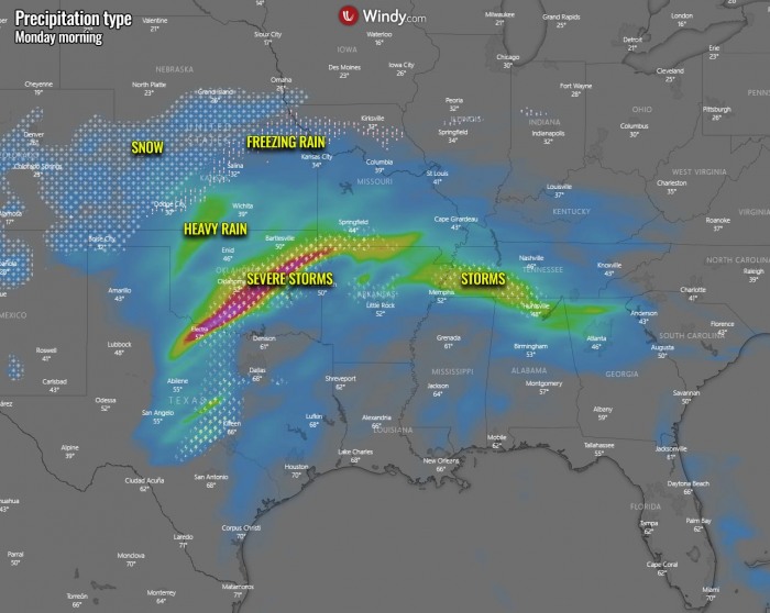
A dangerous winter storm is expected to develop into the central portions of the United States on Monday, bringing a foot of snow from northern Kansas through Iowa. Wintry mix with some ice storm potential is possible to the south of the narrow deep snowpack. Further south, severe storms are likely as well, while a lot of rain spreads into the West and East Coast in this coming week.
While parts of the Midwest are already experiencing some winter weather this weekend, a much more intense winter storm is coming up through early this week, on Monday into Tuesday.
There is a progressive weather pattern developing over the United States with a large upper wave over the West Coast. The wave is bringing much colder air mass far south into the western portions of the country, with quite significant rain and snow event for the region, including parts of California and the desert Southwest.
Further evolution of the weather in the coming days will follow the wave ejecting further east across the Rockies and the central United States. Wave will lead to a dangerous winter storm on Monday through Tuesday, affecting central Great Plains and Midwest with a high amount of snow and also some ice accumulation along the front.
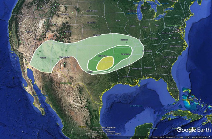
There is also severe weather potential with an enhanced threat of large hail and damaging winds across parts of the southern Plains. The Storm Prediction Center (SPC) has issued a Slight Risk of severe thunderstorms over parts of the Southern Plains on Sunday into Monday morning. Showers and thunderstorms will advance into parts of the Ohio/Tennessee Valleys on Monday.
Along the rain/snow line, rain/freezing rain areas will develop across the Central Plains, Middle Mississippi Valley through Sunday evening. There will be an ice storm along its track, as well as locally quite a deep snowpack to the north, across northern Kansas, southeast Nebraska, and southern Iowa.
By Monday evening, rain moves into parts of the Southeast and southern Mid-Atlantic.
The more significant weather change has started a few weeks ago, which is coming into effect this late January. Let’s see what happened actually.
PATTERN CHANGE FOLLOWED THE POLAR VORTEX COLLAPSE
Through the final days of 2020, there was a world record for the highest surface pressure ever observed, set in Mongolia. It was caused by very cold air with below -50 °F sitting over Russian Siberia.
The Siberian cold then spread towards the Pacific, ramping up the jet stream and lead to another record-setting setup for the North Pacific and Alaska. An extremely deep extratropical storm occurred which pushed the minimum central pressure to new record levels for the region, 921 mbar!
You might be asking now, but why is this important here? These large mesoscale systems were so anomalous, that their dynamics sent the atmospheric waves up into the upper parts of our atmosphere – the stratosphere. The result was a disruption of the Polar Vortex aloft and a major Sudden Stratospheric Warming (SSW) event occurred. The Polar Vortex collapsed.
The warming was so intense that the cold was then displaced and pushed to the south, away from the polar regions. After the Polar Vortex collapse in early January, the weather patterns across the Northern Hemisphere are becoming very dynamic and progressive over the past few weeks. As it often happens, a strong blocking ridge develops over the polar/arctic region with a strong high-pressure system built over Greenland.
One of the effects was a new deep upper trough/wave with a frontal system deepening over southern Canada a few days ago. A reinforced cold front swept across the Great Lakes on Thursday with cold westerly to northwesterly flow across the unfrozen Great Lakes, causing heavy lake-effect snow. The wave moved into the Northeast United States with strong advection of very cold Arctic air mass towards the eastern portions of the US.
Further west, another wave can be seen on the chart above, spreading a significant cold outbreak into the western portions of the United States, starting this weekend. It will extend through the remainder of this month. The attached chart hints at an extreme cold to develop across western Canada and northern/northwestern United States first, then spread towards the West Coast.
With the general pattern sending the upper wave and cold air mass that far south, it also cuts off a potent wave towards the central United States after Sunday. This wave is now becoming the main focus for the weather in the coming days, as a major winter storm will develop across the central parts of the country towards the Midwest on Monday through Tuesday this coming week.
Millions will be in the zone of wintry mix weather coming up over the next 48 hours and can expect travel disruptions and also power outages caused by severe weather hazards.
WINTER STORM DEVELOPS OVER THE CENTRAL PLAINS
As the new wave emerges across the southern Rockies on Sunday, the lee surface low forms over the Plains. Causing a strong warm advection northwards. Setting a stage for a potentially significant winter storm across the central Plains and the Midwest.
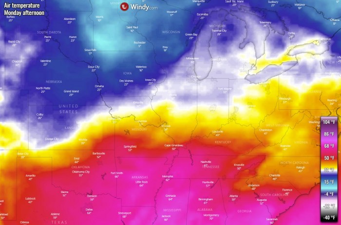
Thanks to the deepening low towards Monday, cold advection spreads behind the front as upper High is established over southern Canada. Meaning the surface flow is meridional, northerly into the United States from the north. This creates a high contrast in temperatures across the country.
With the deepening low, precipitation begins to increase through Sunday night. Snowfall begins from eastern Colorado into western and northern Kansas, to the north of the warm frontal boundary extending from the Panhandsles to northern Missouri on Monday early morning. With still below-freezing temperatures near the surface and much warmer air mass coming north aloft, conditions could support ice storm potential across central Kansas.
Although the potential for freezing rain is rather limited, it may lead to dangerous travel conditions due to black ice on the roads. As the storm progresses further northeast through late Monday morning, precipitation should turn to snow, mixing from the west.
Forecast message from the Dodge City, Kansas NWS Office
Accumulating snowfall appearing more and more likely for southwest and north-central Kansas Sunday night through Monday. Although exact snow accumulations still remain unclear, the best chance of 2 to 4 inches of snowfall will be north and northeast of Dodge City. There is a chance for a wintry mix south of Dodge City and around the Pratt and Medicine Lodge areas Sunday night which will result in lower snowfall totals but it could also produce some minor ice accumulations.
Hazards: Snow totals of 2 to 4 inches possible. Minor ice accumulations not out of the question southeast of Dodge City Sunday night.
Areas Impacted: Snow likely across all of southwest and central Kansas. Currently appears that the highest snowfall totals will be north and east of Dodge City. Minor Ice accumulations will be focused mainly south of Dodge City and in the Pratt and Medicine Lodge areas.
Timing & Duration: Snow developing early Sunday night with the steadier and heavier snowfall being possible from midnight to noon Monday. Snow will taper off Monday afternoon.
Impacts: Hazards travel conditions may develop due to snow-covered roadways.
Further south along the cold front, warm air mass becomes unstable across Texas and parts of Oklahoma. Settings an environment conducive for thunderstorms to develop, including severe storms. See further down for details on this matter.
WINTER STORM INTENSIFIES ON MONDAY
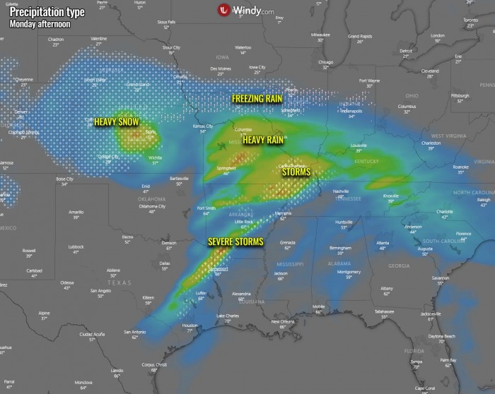
Through daytime Monday, the surface low peaks so the precipitation increase further. This will introduce very heavy snow across central Kansas, thanks to the advection of colder air mass in the system’s wake while moist air is still pumping north with the low over Oklahoma. A near-ideal recipe for heavy snow.
Freezing rain potential will spread across northeast Kansas, northern Missouri into central Illinois and Indiana. To the north of this frontal line, heavy snowfall will begin.
To the south, heavy rain and storms move further east into Missouri and Arkansas, with some potential for severe storms remaining along the front extending towards eastern Texas. The advection of very warm air mass will continue towards the central Mississippi Valley, with also high dewpoints that will lead to heavy rain with the frontal storms.
The advection of colder air mass from the Northern Plains will spread south across Nebraska into western Kansas and Colorado. Being the most intense over Minnesota and North Dakota, with Highs in the 5-10 °F range.
Below is the forecast message from the Topeka, Kansas NWS Office which area will see worsening conditions from late Monday morning onwards.
Significant snowfall is likely for much of the area Sunday night through Monday afternoon. Light drizzle and freezing drizzle are possible Sunday evening with precipitation changing to a wintry mix of light freezing rain and snow overnight then to mostly snow north of the Interstate 35 Monday morning through the late afternoon.
Heavy snow is expected in north-central and northeast Kansas, with a tight gradient to much lesser amounts to the south. Those planning travel in the heavy snow area should consider alternative plans.
Wintry mixture develops Sunday night, changes to nearly all snow Monday morning, and ends Monday evening. A Winter Storm Watch is in effect for
locations generally north of the Kansas Turnpike/I-335. Moderate to even heavy snow accumulations are likely Monday.
Hazards: Freezing drizzle possible
Areas Impacted: Portions of north-central and northeast Kansas, but primarily in Republic and Washington counties.
Timing & Duration: Mainly this evening but it could linger into the overnight.
Impacts: Some slick roads are possible, especially on elevated surfaces and untreated roads.
SNOW CONTINUES INTO MIDWEST THROUGH MONDAY EVE
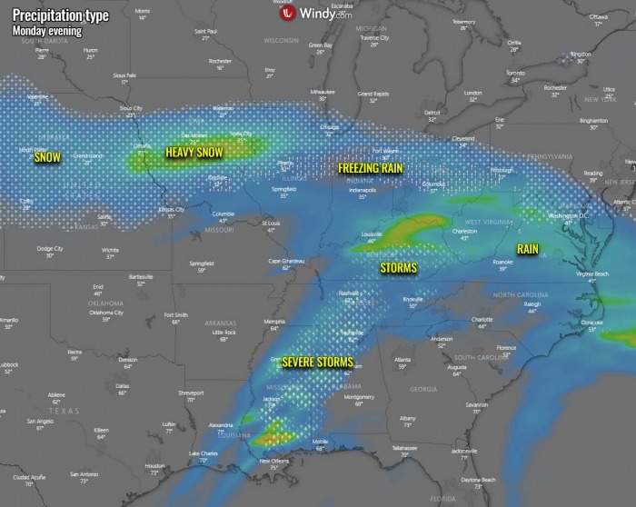
With time, the increasing precipitation also spread into the southern parts of the Midwest United States. Very heavy snow with significant snow accumulations is likely from southeast portions of Nebraska, across southern Iowa into western Illinois. More than 10 inches of snow is quite possible in this narrow zone as conditions will be favorable for high snowfall rates for a long time while the winter storm slowly drifts east.
Freezing rain/ice storm potential will remain further east towards the Ohio Valley on Monday evening into the night. Precisely from central Illinois, central Iowas into central Ohio.
Further south, the cold front will continue advancing east across the Lower Mississippi Valley and towards the Southeast United States through Monday night. Some potential for severe storms will remain across Mississippi, Alabama, and Tennessee.
Below is a Forecast message from the Omaha, Nebraska NWS Office regarding the potential in the area of both Nebraska, Iowa, and northern Illinois through Monday evening hours:
A powerful winter storm system with high impacts will bring snow accumulations of 4-12 inches along and south of interstate I-80 on Monday. Wind gusts up to 25 mph will help reduce visibility as roads become slick and difficult to travel. Expect heaviest snowfall rates between noon and 6 pm, impacting the evening commute.
Lighter amounts, and possibly little accumulation is expected for northeast Nebraska. Additional light snow is forecast for Tuesday into Tuesday night. Travel will become difficult at times.
WINTER STORM WATCH remains in effect from Monday morning through late Monday night as freezing drizzle and ice accumulations of up to one-tenth of an inch for portions of southeast Nebraska. Additionally, heavy snow possible. Total snow accumulations of 5 to 8 inches possible.
Forecast message from the Dew Moines, Iowa NWS Office
Confidence is increasing that a significant winter storm will impact central and southern Iowa Monday and Monday Night with widespread moderate to heavy snow. Snow amounts from 6 to 10 inches are possible from the Interstate 80 corridor south to the Missouri border, with localized higher amounts possible. Thundersnow is even not out of the question.
The greatest uncertainty in the snow amounts will be through central Iowa, including the Des Moines area, where amounts may vary greatly over short distances north to south. The snow will be accompanied by brisk winds and blowing snow producing low visibilities in open areas.
Travel will be difficult on unplowed roads in the heavy snow areas, even not taking into account low visibilities. The Monday evening commute will be greatly impacted. Travel may need to be postponed or rescheduled.
Forecast message from the Chicago, Illinois NWS Office
There is increasing potential for a winter storm to impact the region Monday and into the day Tuesday. Snow accumulations of at least several inches are expected north of I-80, and the likelihood of some locations within this area seeing significant accumulations is increasing.
A wintry mix, including freezing rain, is likely south of I-80. In addition, strong and gusty northeast winds combined with elevated lake levels will likely cause lakeshore flooding impacts Monday evening into early Tuesday.
Impacting winter weather is in the forecast for at least a large part of the area for Monday-Tuesday, as details gradually become more refined. Still some noteworthy uncertainty though on placement and duration of wintry weather. The orange shaded area though continues to look the most favored for snow totals exceeding 4 inches and potentially exceeding 6 inches.
The snow will be a heavy, wet type of snow. Continue to check our other graphics and more information if traveling during that period. The expected snow will be of a wetter type. Winds will gust at a time to or even above 30 mph Mon night. Continue to check back on the latest forecast if needing to travel at all Monday through Tuesday.
The freezing rain potential will develop in a rather narrow zone throughout Monday. Basically very near the warn frontal zone moving east-northeast during the day. Although the ice accumulations are unlikely to be significant, travels could be disrupted. The latest model guidance suggests the highest potential is from northeast Kansas across northern Missouri, central Illinois to northern Indiana and Ohio.
To the north of this line, very heavy snowfall should result in high snow accumulation with this winter storm. Potential is the highest across northern Kansas, south-southeast Nebraska and southern Iowa. These areas could receive near 8 to 12 inches of snow by Tuesday morning, potentially even more – close to 15 inches – if heavy snow bands develop and persist for a longer period of time.
A precipitation type is strongly related to the exact position of the frontal boundary where freezing rain, snow, or just rain will occur.
Nevertheless, an increasing potential is definitely in a place that the wintry conditions will develop along with the frontal system.
WHAT IS SLEET OR FREEZING RAIN?
The freezing rain forms when a layer of warm air aloft is placed above a layer of below-freezing (subfreezing) air at the surface. Snowflakes that falling towards the ground, melt as they fall through this warm layer.
If the flakes are completely melted, then it is falling as rain towards the ground which is much colder. This liquid droplet then freezes on contact with exposed surfaces.
Sleet or ice pellets are a form of precipitation consisting of small, translucent balls of ice. Ice pellets are smaller than hailstones and are different from graupel. Ice pellets often bounce when they hit the ground or other solid objects (e.g. jackets, windshields, and dried leaves). They generally do not freeze into a solid mass unless mixed with freezing rain.
SEVERE STORMS FOR SOUTHERN PLAINS
Further south of the core with this winter storm, a strong warm advection will be underway, associated with the surface low traveling across the southern Great Plains. The surface low typically forms in the lee side of the Rockies with an upper wave/through emerging from the west. The process deepens the low.
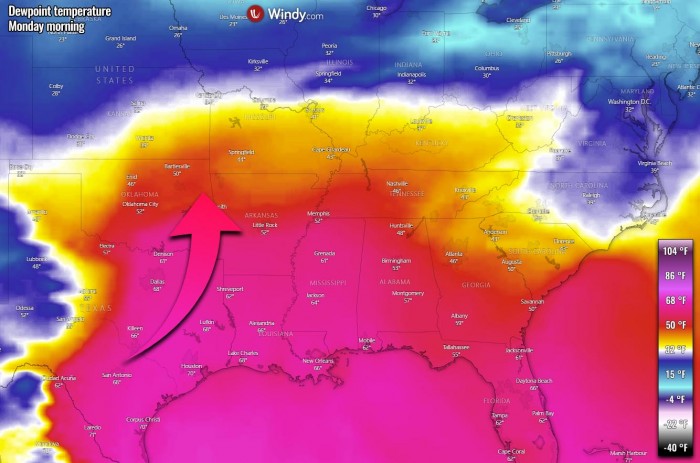
With the pressure falls over the southern Plains, rather strong southerly winds will be advecting moist and warm air mass from the warmer Gulf of Mexico further north across the Plains and the Mississippi Valley. Leading to an unstable environment ahead of the moving frontal system.
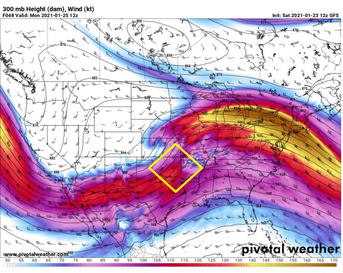
This will push dewpoint temperatures into low to mid-60s °F far north, past the Red River and central Arkansas. Unstable air mass under the left-exit region of an upper-level jet stream will introduce another region for dangerous severe weather threat through late Sunday night into Monday morning.
According to the Storm Prediction Center (SPC), a few severe storms capable of producing hail, damaging wind gusts, and perhaps even a brief tornado may occur over portions of North Texas, southern and eastern Oklahoma, and also Arkansas from Sunday evening through Monday morning. An SLGT (slight) risk has been issued.
Here is the forecast discussion from the SPC:
Southern Plains into the Ozark Plateau
Based on recent satellite imagery, a shortwave trough currently extends from the western Great Basin southwestward across central California. This shortwave is expected to continue gradually southeastward today before then pivoting more eastward late tonight/early tomorrow morning. The shortwave is then forecast to become more progressive as it moves across the Southwest on Sunday and into the southern Plains on Sunday night.
A second shortwave trough, accompanied by strong upper flow through its western periphery, is expected to drop southward along the California coast Sunday evening/overnight. Progression of this second shortwave will help maintain broad upper troughing across the western Contiguous United States into early Monday.
Modest moisture return is anticipated throughout the warm sector in place over southern Plains ahead of the lead shortwave. The consensus among the guidance brings low 60s surface dewpoints to the Red River by late Sunday evening. Low-level stability should preclude afternoon/evening storms across much of Texas.
A few stronger updrafts may develop amid persistent warm-air advection during the afternoon/evening from northeast Texas northeastward across eastern Oklahoma and across Arkansas. Modest instability should limit both updraft depth and longevity, but strong vertical shear could result in a few updrafts strong enough to produce hail.
Greater storm coverage (and attendant severe potential) is expected late Sunday night into early Monday morning as the surface low associated with the shortwave moves from northwest Texas into northeast Oklahoma. The highest thunderstorm coverage is currently anticipated along and just north of the surface low track.
Instability will be modest, but very strong vertical shear could result in a few stronger updrafts capable of hail. Additionally, low-probability potential exists for a few surface-based storms in the vicinity of the front from northeast Texas into far southeast Oklahoma to far southwest Arkansas. Given the strong low/mid-level flow, a threat for damaging wind gusts and perhaps even a brief tornado could accompany any surface-based storms.
The overview graphics by the National Weather Service in Norman, Oklahoma above hint a few severe storms with hail up to the size of quarters, winds up to 60 mph and very low tornado potential is possible late Sunday into early Monday morning.
RECAP: POTENT WINTER STORM WITH LOT OF PRECIPITATION
This new winter storm, ejecting of the significant trough into the western Contiguous United States, will introduce dangerous travel conditions as severe winter weather is forecast. There are likely high snowfall accumulations across portions of the North-Central Plains and the Midwest, with locally close to 15 inches of snow by Tuesday.
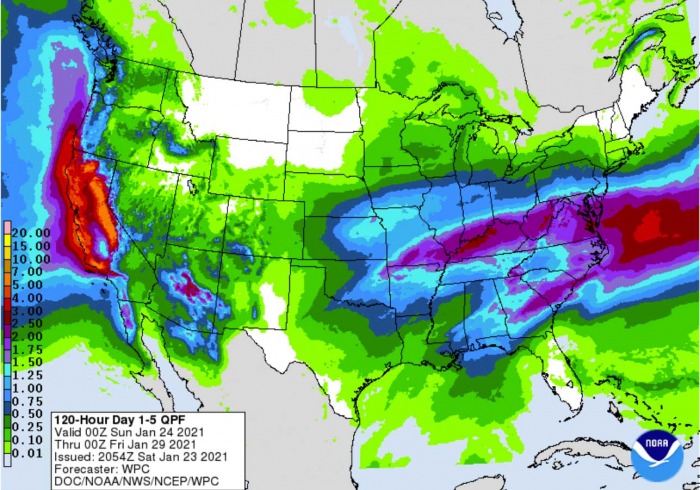
To the immediate south of this broad swath of heavy snow, freezing rain potential could bring some minor ice accumulations. And a lot of rain is expected to accumulate with the while system through the next 5-7 days, gradually spreading towards the East Coast of the United States.
The channel established from western Canada opens the flow of much colder weather than normal towards the south, actually pretty far south across the West Coast, Baja California peninsula, and the desert Southwest US. Temperatures could drop much lower than normal, even near 15 degrees below average in some areas.
And probably the most important effect of the event for the West is the relief for the severe drought conditions ongoing from California into the Southwest United States, so this rain is much appreciated there. Indeed as heavy snow over the Sierra Nevada and further east-northeast into the Rockies.
IMPORTANT UPDATE:
***The images used in this article were provided by Windy, Wxcharts, and NOAA.


