Yet another wintry cold wave is moving across southern Canada into the Great Lakes tonight into Friday. It will intensify the ongoing heavy lake-effect snow event over the Lakes and develop a severe cold for the Northeast United States into the weekend. Then, a cold outbreak heads for the West Coast and develop a new winter storm for the central parts of CONUS early next week.
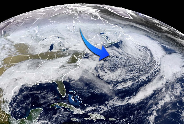
Currently, there is an impressive, explosive development of an extratropical storm, located over the Northwest Atlantic, to the south of Newfoundland. It is causing the cold air mass to spread across New England this Thursday. The low will eject east tonight and the advection of cold will temporarily vanish.
It will be followed by another pocket of deep, much colder Arctic air mass towards the Northeast United States over the weekend. A winter storm will spread a good amount of lake-effect snow over the Great Lakes and severe cold towards the East Coast of the US through Friday and Saturday.
On the satellite scan above, we can also see that the snow coverage across the Midwest and the Great Lakes is quite significant. But the lakes are ice-free.
IT ALL BEGAN IN LATE DECEMBER
In the final days of 2020, there was a new world record for surface pressure readings set in Mongolia. Caused by a frigid cold air with near -55 °C over Russian Siberia. As this Arctic cold from Siberia spread towards the Pacific, it met with the warm Pacific tropical air mass coming up with the powerful jet stream between these two air masses.
The result was another record-setting setup for the North Pacific and Alaska. The very explosive development of an extratropical storm occurred, and pushed the minimum central pressure at 921 mbar, smashing the previous pressure records in the region.
But why is this important? These large scale systems were so extreme and anomalous, that their dynamics sent the atmospheric waves up into the upper parts of our atmosphere, called the stratosphere. Disrupting the polar vortex aloft and started a major sudden stratospheric warming (SSW) event and lead to vortex collapse.
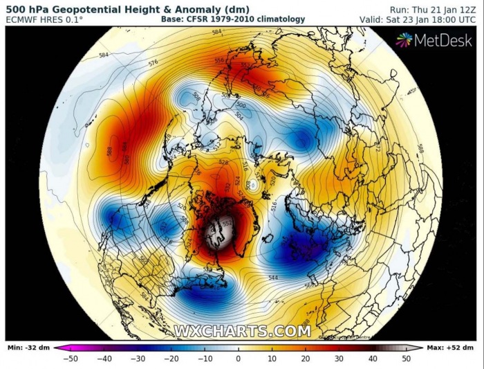
The warming was so intense that the cold was then displaced and pushed to the south, away from the polar regions. After the Polar Vortex collapse through early January, the weather patterns across the Northern Hemisphere are becoming very dynamic and progressive over the past few weeks. As it often happens, a strong blocking ridge develops over the polar/arctic region with a strong high-pressure system built over Greenland.
One of the effects is a new deep upper trough/wave with a frontal system deepening over southern Canada this Thursday.
Associated with the new frontal wave coming down from Canada, a reinforcing cold front will sweep across the Great Lakes through Thursday night into Friday morning. The front will be producing favorable cold westerly to northwesterly flow across the unfrozen Great Lakes.
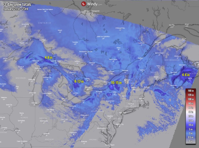
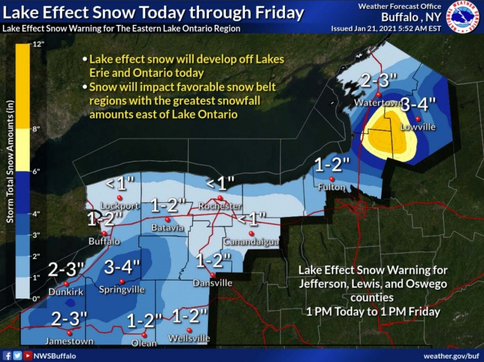
Typically, this means that a winter storm with lake-effect snow will increase in coverage and intensity tonight and continue through Friday. Locally heavy snow accumulations are likely with the heaviest totals expected over western and northwestern portions of New York State, downwind from Lakes Erie and Ontario.
And then, as the wave moves further east across the Northeast United States into the Northwest Atlantic, it continues deepening. And intensifies the ongoing advection of very cold Arctic air mass towards the south, spreading the cold into the eastern portions of the US.
The upper-level ridge and an associated surface high-pressure system develop further west, across the central United States. This helps the meridional flow to persist into the weekend. Maintaining northwesterly winds across the Great Lakes and towards the East Coast and the Northeast.
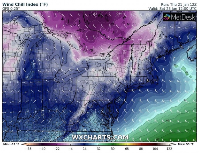
Therefore resulting in very cold wind chill temperatures, from around 0 to near -10 °F (-20 to 25 °C), even much colder further north in Canada. Below -30 °F (-35 °C) there!
SIGNIFICANT LAKE-EFFECT SNOW
The winter storm will be moving across quite fast, thanks to the building upper High over the central and northern parts of the United States through Friday into Saturday. The frontal system moving across southern Canada will trigger stronger northwesterly winds in between these two systems.
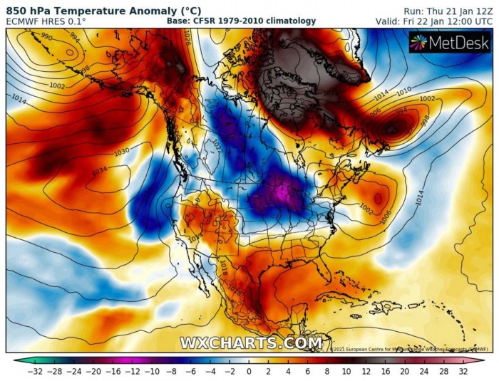
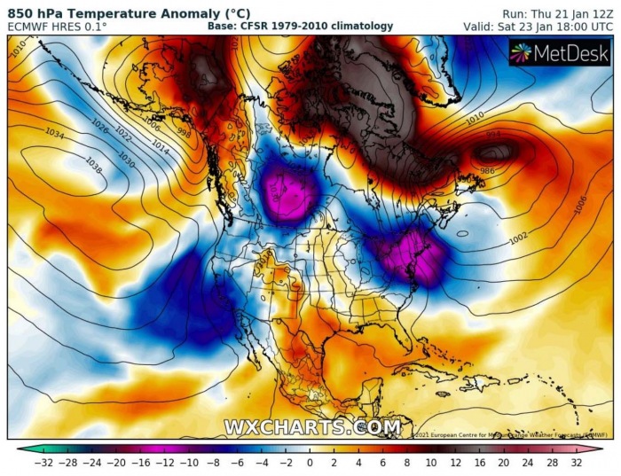
This will help the ongoing advection of colder air mass over the Great Lakes through Saturday, gradually intensifying the lake-effect snow as the storm progresses east and northwest winds increase with it. The air mass will be much colder than normal for late January, even more than 12 °C colder than the average for this time.
While we can see the colder air is also spread further across central Canada. But there an extreme positive anomaly over Arctic Canada towards the Labrador Sea and western Greenland. This is the result of the strong blocking ridge over the polar region and Greenland, with descending air masses towards the surface. Causing the lowest layers to warm up into nearly 15 °C warmer temperatures than normal.
The most affected areas with a good amount of snow will first be the northern portions of the Lower Peninsula of Michigan, downwind of Lake Michigan; and along the north coast of the Upper Peninsula of Michigan, downwind of Lake Superior through Saturday.
Then, the activity spreads towards the Ontario and Erie Lakes eastern shores. Generally, 5-15 inches of snow will be possible, locally even more over the next three days.
LAKE EFFECT SNOW WARNING remains in effect until 1 pm Friday as heavy lake-effect snow continues to the east of the Eastern Lake Ontario Region. The greatest snowfall will be confined to the Tug Hill Plateau. Additional snow accumulations of 8 to 15 inches in the most persistent snow squalls.
The heaviest snow will occur tonight through Friday morning and travels will be very difficult with deep snow cover on roads with poor visibility. The hazardous conditions could impact the evening commute and the morning commute on Friday.
Heavy snow will fall in relatively narrow bands. If traveling, be prepared for rapidly changing road conditions and visibilities.
Northwesterly flow will also push enough moisture further towards the Mid-Atlantic region, so some snow showers are likely to reach there as well, including the busy Intestate I-95 corridor with some flurries possible in New York and Philadelphia on Friday.
But the greatest snows will remain over the Lakes.
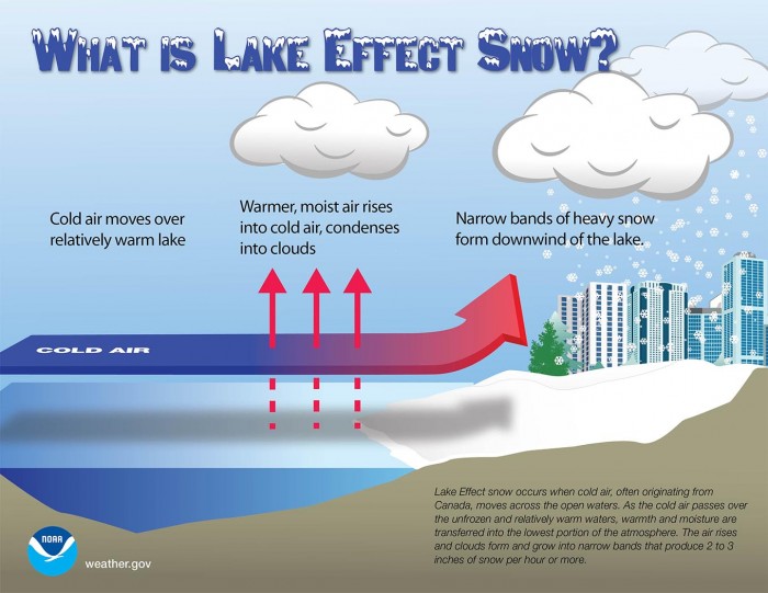
The lake-effect snow is common across the Great Lakes region during the late fall and winter. It occurs when cold air, often originating from Canada, moves across the open waters of the Great Lakes.
As the cold air moves over the unfrozen and still relatively warm waters of the Great Lakes, warmth and moisture are transferred into the lowest portion of the atmosphere. The air rises, clouds form and grow into a narrow band that produces heavy snow bands with 3-5 inches of snowfall rates.
The key component is the wind direction which determines which areas will receive lake-effect snow. Heavy snow typically occurs in very narrow bands and squalls, so it may be falling in one location, while the sun may be shining just a mile or two away in either direction.
SNOW VANISHES, BUT COLD INTENSIFIES
Going into the weekend, the upper wave and the associated frontal system moves off to the Northwest Atlantic and over Newfoundland, southeast Canada. The low intensifies as the cold upper levels meet the warmer Atlantic. Further west, the developing ridge pattern from Friday also strengthens, building up into the omega blocking ridge.
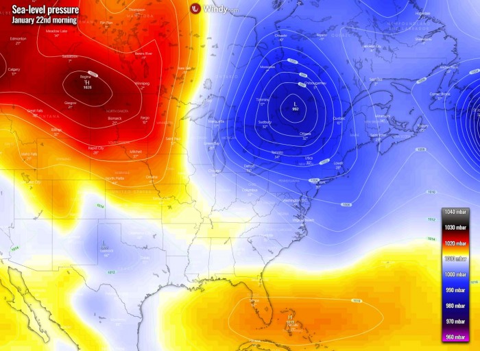
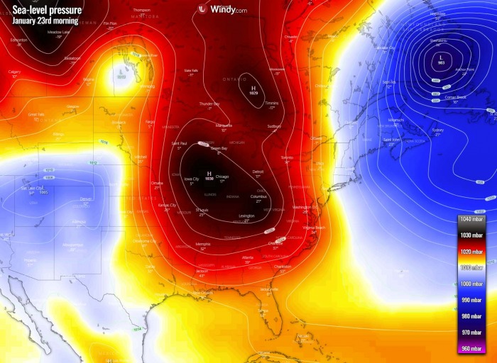
So the surface pressure begins rising quite significantly on Saturday, centered over the Midwest and Ohio Valley. Actually, it will build up across most of the eastern part of the Contiguous Unites States, except the far northeast part which will be on the west side of a deep low over Newfoundland.
This will bring more stable weather for the East Coast and the Great Lakes. So the winter storm with lake-effect will gradually vanish through Friday night into Saturday morning. But higher pressure also means colder weather will develop. Thanks to the strong pressure gradient between the two systems, north-northwesterly flow is perfectly established towards the Mid-Atlantic Coast.
The Arctic cold advection will first spread across the Midwest on Friday, also across the Great Lakes, and further towards the Northeast. Around 10-15 °F below normal temperatures are forecast for the Midwest, including the city of Chicago.
The advection of very cold air mass will continue on Saturday, maintaining near 12 °C colder temperatures than normal across the lowest parts of the atmosphere. The cold will be spread across the Great Lakes, the Northeast United States as well as over the East Coast. The extremely anomalous air mass over Arctic Canada, the Labrador Sea, and Greenland will maintain beneath the strong ridge aloft.
In the morning hours, the temperatures will dip below zero Fahrenheit across parts of the Midwest. And thanks to the cold winds, the Northeast will experience even lower temperatures. The cold blast will spread all the way to the Atlantic coast, including the I-95 corridor. Breezy cold is forecast from Washington, D.C., across New York to Boston on Saturday morning.
The combination of much colder air mass arriving over the weekend and quite strong northwesterly winds will cause low windchill temperatures over this part of the United States. The temperature feels colder than 0 °F (-17 °C) will spread across parts of Pennsylvania, New York, Vermont, and New Hampshire states.
Even colder temperatures will be experienced further north in southeast Canada. Windchill temperatures from -20 to even below -30 °C (-35 °C) are likely under the core of the cold poor there. Daytime temperatures will also remain very low over the weekend.
NEXT WINTER STORM FOR THE CONUS ON MONDAY
In one of our discussions lately, we were talking about some similarities the Polar Vortex collapse has made to this years’ winter pattern with the famous January 1929 extreme cold period. The winter of 1928/29 is known as one of the coldest in the past century.
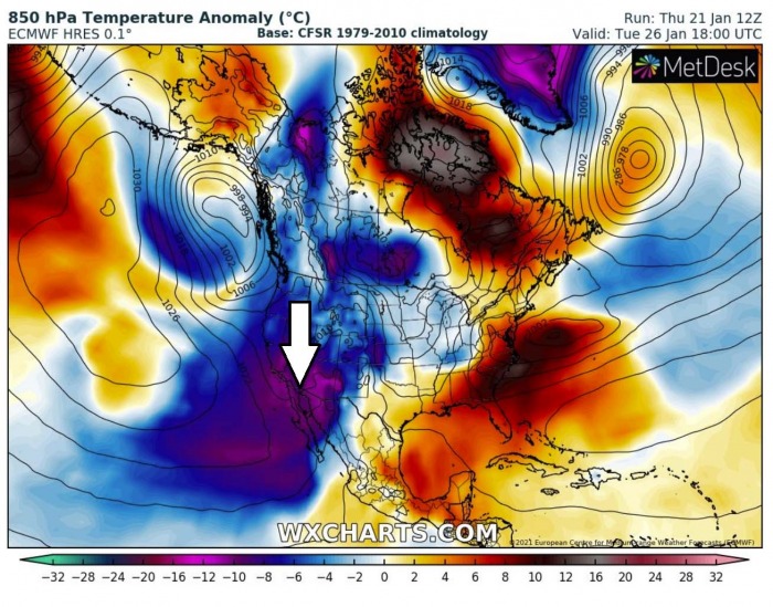
The weather models are still trending towards the scenario that we will also see a significant cold outbreak into the western portions of the United States after this weekend, extending through the remainder of this month. The attached chart hints at an extreme cold to develop across western Canada and northern/northwestern United States first, then spread towards the West Coast.
By early next week, the channel established from western Canada opens the flow of much colder weather than normal towards the south, actually pretty far south across the West Coast, Baja California peninsula, and the desert Southwest US. Temperatures could drop much lower than normal, even near 15 degrees below average in some areas.
But probably the most important effect of this event is the relief for the severe drought conditions ongoing from California into the Southwest United States, so any rain will be much needed there. Indeed as heavy snow over the Sierra Nevada and further east-northeast into the Rockies.
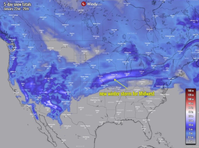
As the general pattern pushes the wave that far south, it also cuts off a wave towards the central United States after Sunday. And this is now becoming a real concern as the global weather models are now hinting a major winter storm could develop across the central parts of the country and further east on Monday through Tuesday next week.
Indeed it is yet to be defined where exactly the new winter storm would travel, but a quite significant snowpack is forecast by the models from the Midwest towards the Great Lakes and Ohio Valley.
We will be posting more updates on this storm over the weekend, stay tuned.
***The images used in this article were provided by Windy, Wxcharts, and NOAA.
