The Polar Vortex is getting stronger before the Winter Season 2021/2022, yet it is already facing its first stratospheric warming event. An unusually early warming event is starting over the Polar regions, with more warming forecast to follow into the late month.
The Polar Vortex is without a doubt one of the key weather players during the cold season. It is strongly connected all the way from the ground up, high into the stratosphere. Every strong power change or especially disruption of the Polar Vortex can have a profound effect on the weather development. This is why we take great notice of the activity high above in the stratosphere and monitor it regularly.
Before explaining what is up with the Polar Vortex and our weather, we will quickly learn what exactly is the Polar Vortex and why is it so important. We try to explain this in most of our winter articles. Knowledge is essential and powerful and can make everyday weather events easier to understand, once you see how it fits into the bigger picture.
HIGH OVER THE NORTH
All of the clouds and weather, in general, are found in the lowest layer of the atmosphere called the troposphere. It reaches up to around 8 km (5 miles) altitude over the polar regions and up to around 14-16 km (9-10 miles) over the tropics.
Above it, we have a much deeper layer called the stratosphere. This layer is around 30 km thick and is very dry. This is where the Ozone layer is. You can see the layers of the atmosphere on the image below, with the troposphere on the bottom and the Stratosphere with the ozone layer above it.
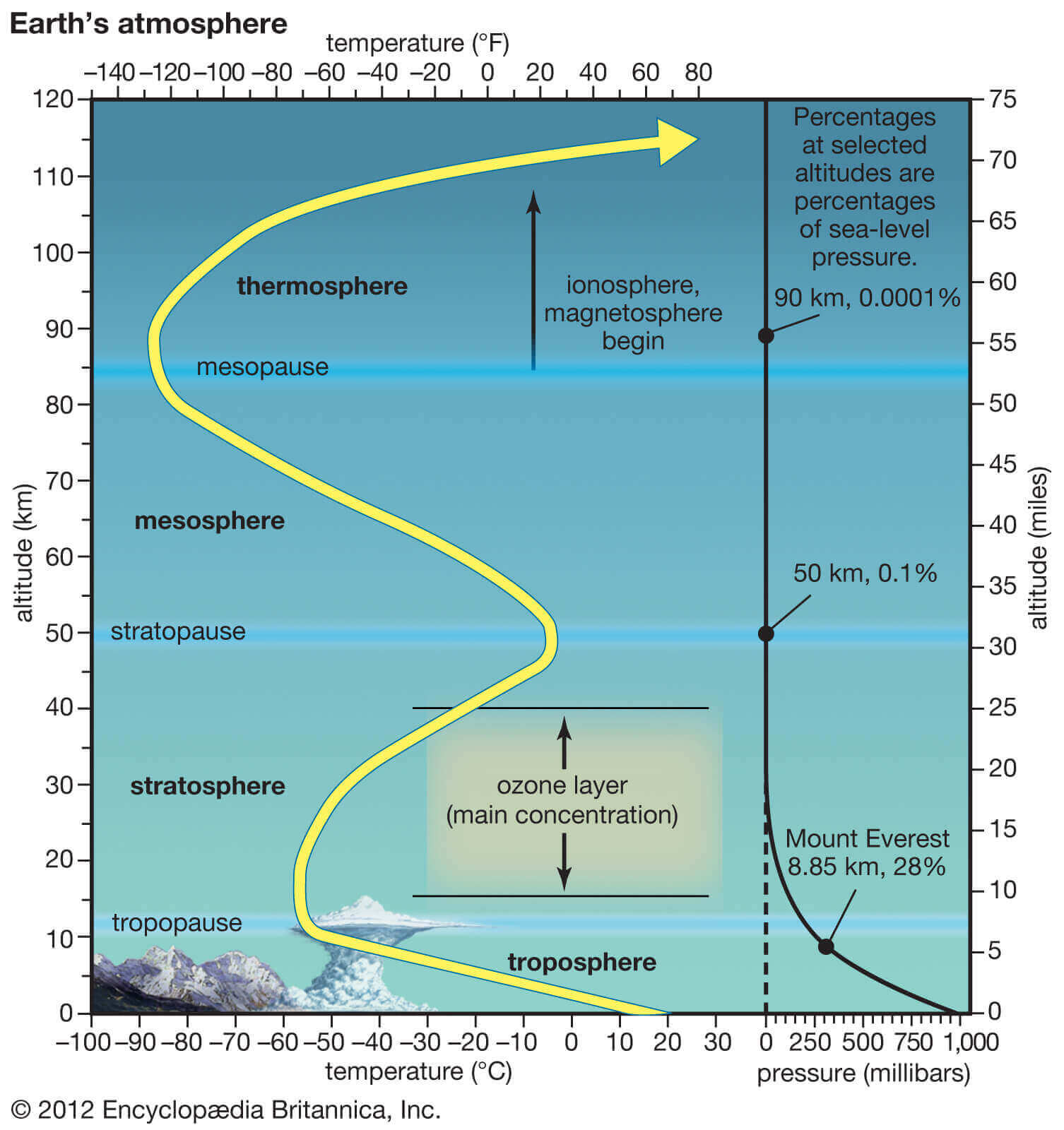
These layers are very important, because when you hear meteorologists and climatologists talk about the polar vortex and its influence, in most cases they mean the higher altitude – stratospheric part. But the polar vortex covers most of the bottom half of the atmosphere from the very ground up.
While the stratospheric polar vortex is spinning high above our weather, it is still directly connected to the lower part and can shape our daily weather in one way or another, as one large hemispheric circulation.
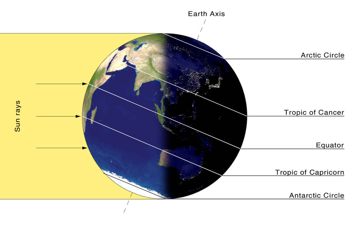
But how does the polar vortex even form? Every year as we head into autumn, the polar regions receive much less sunlight over time. This means that the north pole starts to cool down. But as the polar regions cool, the atmosphere further south is still relatively warm as it continues to receive energy from the Sun. You can see the winter solstice on the image below when the polar regions receive little to zero solar energy.
As the temperature drops over the polar regions, so does the pressure. In the stratosphere, the process is the same. As the temperature drops over the pole and the temperature difference towards the south increases, a large low-pressure (cyclonic) circulation start to develop across the polar stratosphere.
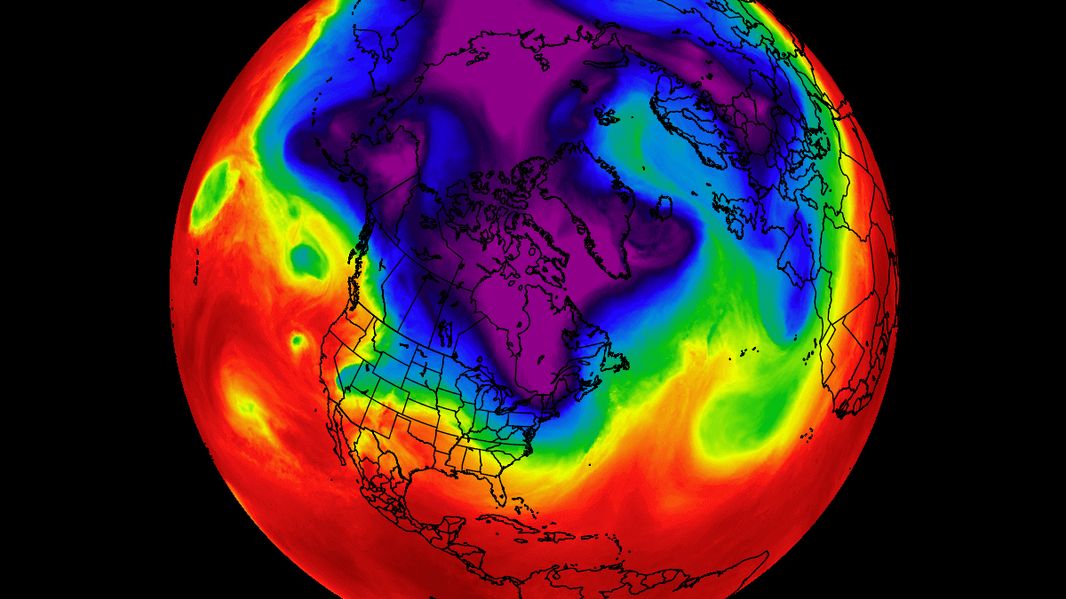
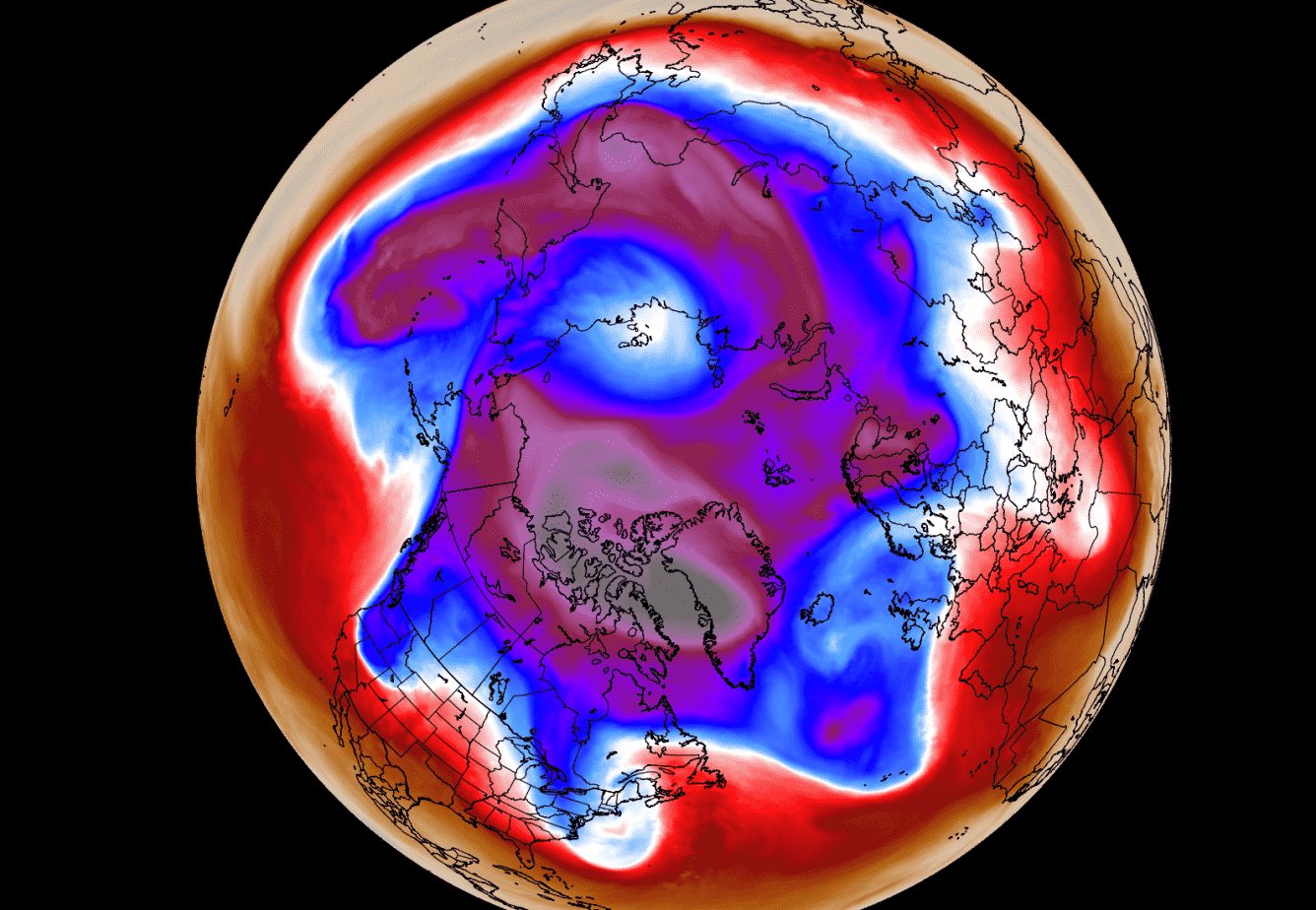
The image below shows a typical example of the Polar Vortex at around 30km/18.5miles altitude (10mb level) near the top of the stratosphere during the winter season.
The polar vortex is basically like a very large cyclone, covering the whole north pole, down to the mid-latitudes. It is strongly present at all levels, from the ground up, but can have quite a different shape at different altitudes.
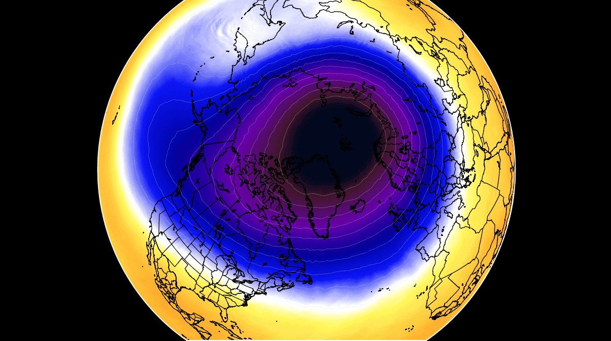
The next image below will show you the polar vortex at a much lower altitude, around 5km/3miles. It reveals the true shape and size of the polar vortex closer to the ground (cold colors). The closer to the ground we go, the more deformed the polar vortex gets, because of the increased terrain/ground influence and the dynamics from many weather fronts and systems.
Be aware of its cold “arms” extending into the lower latitudes, also bringing along colder air into the region.
For an even better idea, we produced a high-resolution video for you below, which very nicely shows the Stratospheric Polar Vortex spinning over the Northern Hemisphere at around 30km/18.5miles altitude.
Video shows December 2020 to January 2021 period, made from NASA GEOS-5 data. We used the vorticity parameter, which (simplified) means that it shows the energy of the polar vortex. Notice how the polar vortex covers a large part of the Northern Hemisphere. You can see how the stratospheric “anti-vortex”, deformed and attacked the Polar Vortex, spinning in the opposite (clockwise) direction over the North Pacific.
The main takeaway from the video should be that the Polar Vortex is not just one single winter storm that moves from the Midwest to the northeastern United States. It is one large cyclonic area that is spinning over the entire Northern Hemisphere, from the ground up to the top of the stratosphere at nearly 50km/31miles altitude.
A strong polar vortex usually means strong polar circulation even in the lower levels. This can usually lock the cold air into the Polar regions, creating milder winters for most of the United States and Europe. On the other hand, a Polar Vortex collapse is just as dynamic as it sounds, as the higher pressure comes crashing down, pushing the cold air out of the polar regions, into the United States and/or Europe.
Typically, a polar vortex circulation collapses due to a rise in temperature in pressure in the stratosphere. That is called a Sudden Stratospheric Warming (SSW) event. And as the name suggests, it is a sudden rise in temperatures in the stratosphere. You will learn much more about the SSW events further below, and how the SSW event in January 2021 changed the Winter season.
POLAR VORTEX – COLD SEASON 2021/2022
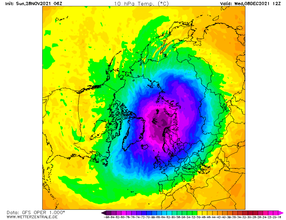
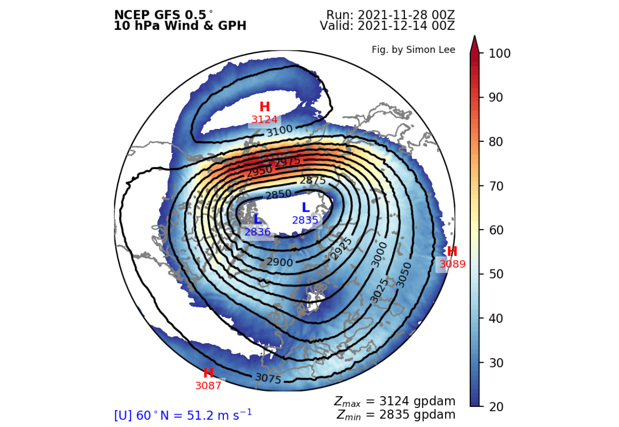
Usually, we look at the polar vortex in the stratosphere at the 10mb level. That is around 28-32km (17-20 miles) in altitude. This altitude is considered to be in the middle of the stratosphere and provides a good representation of the general dynamics of the stratospheric polar vortex.
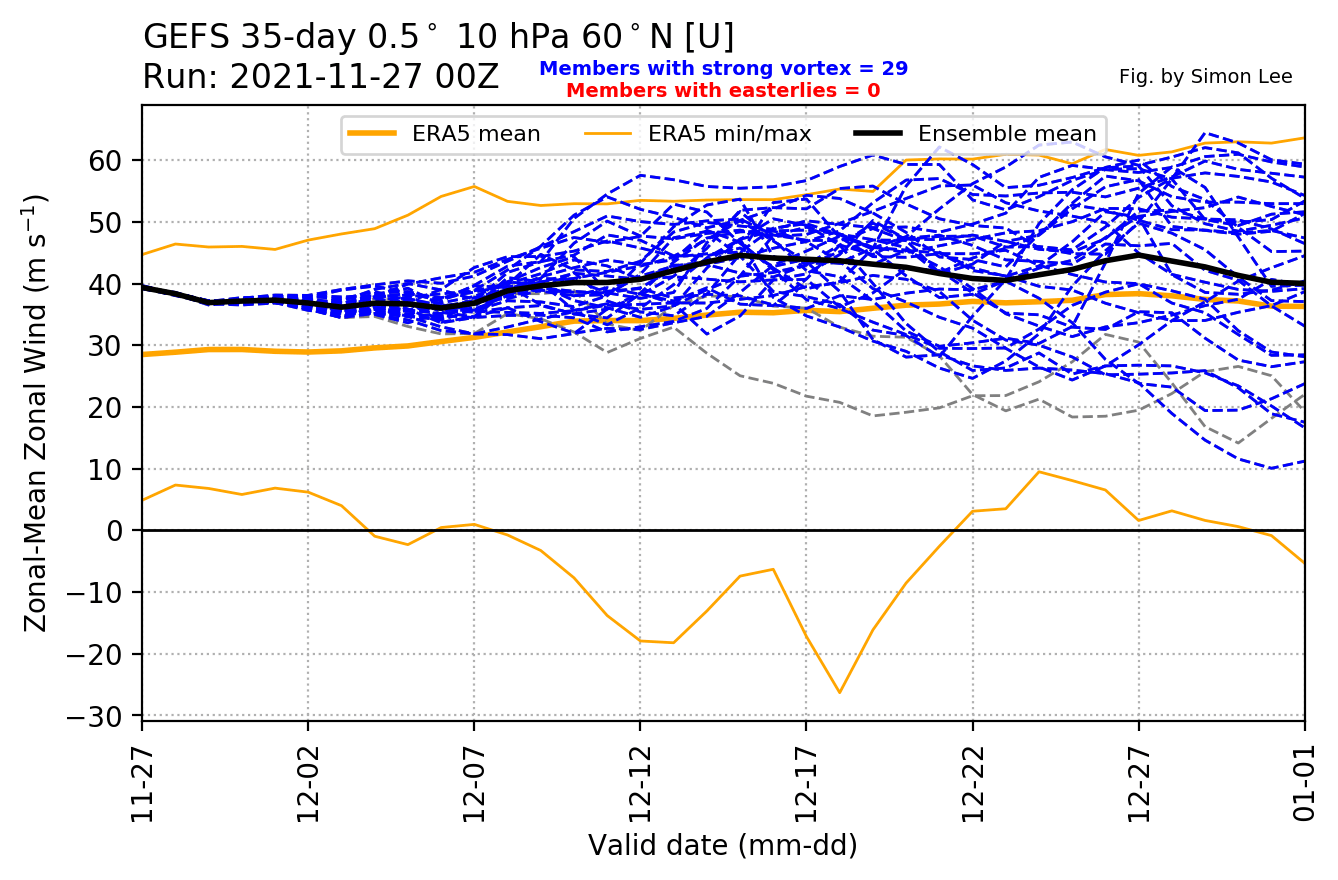
The strength of the polar vortex is most often measured by the power of the winds inside it. Usually, this is done is by measuring the zonal (west to east moving) wind speeds around the polar circle (60°N latitude). Below we have an ensemble forecast for the 10mb winds.
At this time of year, we still have a fairly steady cooling trend over the polar regions. This generally means lower pressure and stronger winds. The image below shows the wind speed forecast in the stratosphere. Currently, the polar vortex is actually stronger than normal.
Currently, we can see that the stratospheric polar vortex looks to be in a good shape. It has a classic circular shape and a stable broad wind field. There is a semi-persistent high-pressure area in the North Pacific.
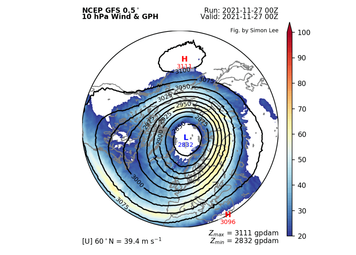
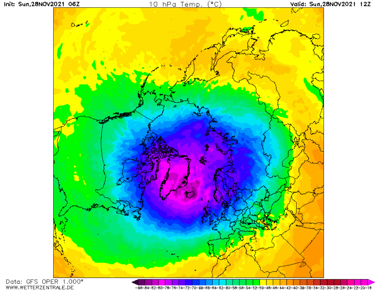
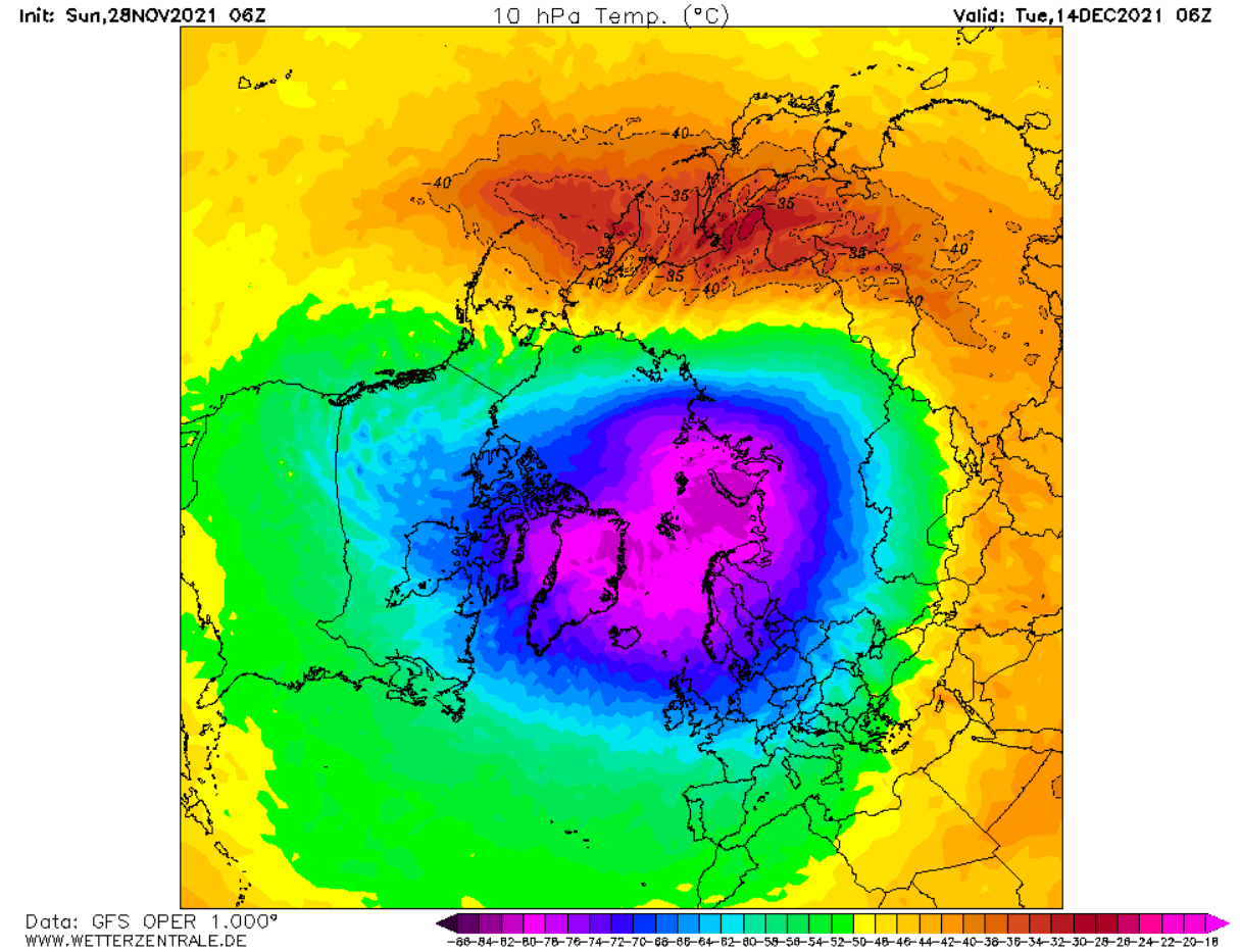
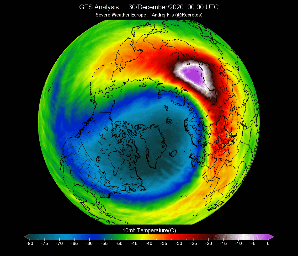
The temperature at this level will be normal for this of the year over the Arctic region. The cold of the polar vortex at 10mb level is reaching below -80°C and is still cooling at this point in time.
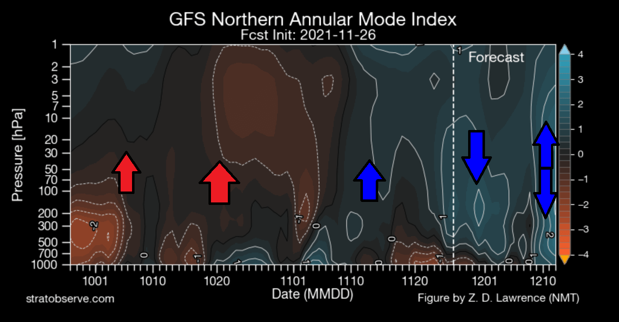
Looking at the pressure anomalies over the polar regions in the past two months, we can see an interesting progression. The image shows pressure anomalies in the vertical. Notice the strong high-pressure buildup in early October, also progressing into the stratosphere. That was a slight disruption to the polar vortex. But lately, the pressure is dropping again in the stratosphere, also connecting downwards over time.
Now going to the forecast for the next few days, we have the ECMWF ensemble forecast, showing the pressure anomaly at 500mb. That is at around 5km altitude and shows the state of the lower level polar vortex. We can see that the polar circulation is quite dynamic, showing many waves of high and low-pressure systems. This still shows a connection to the strong stratospheric polar vortex in the core, as the pressure over the Polar Regions is mostly lower than normal.
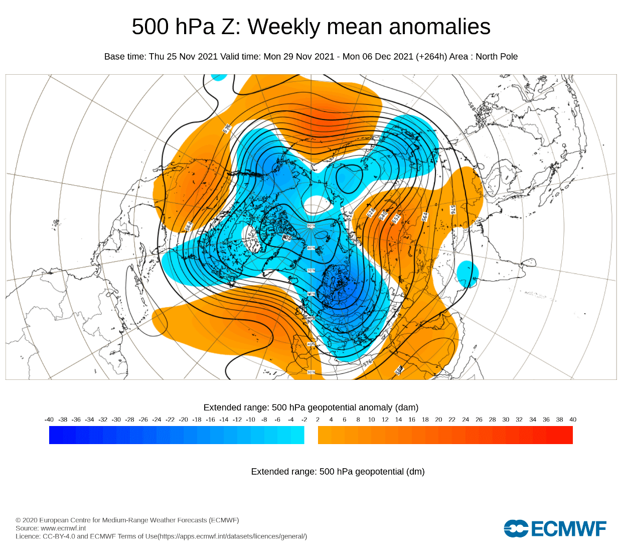
But despite the core connection, the strong wave dynamics are keeping their momentum, preventing the cold air to be fully locked out in the polar regions. So we have an Atlantic high-pressure system that helps to transport cold air into Europe. And we have a ridge over the western United States that helps to bring down colder air into the central and eastern United States.
The temperature forecast also shows this dynamic pattern. We can see colder air remaining over Europe (especially Scandinavia), and over most of Canada and the northeastern United States. An expanding high-pressure area over the United States will bring a warmer than normal air mass over much of western and southern United States.
Going forward, we will see some activity going on in the stratosphere, with the high-pressure area shifting over the North Pacific. That will help to push the core of the polar vortex more towards Siberia, as we can see in the image below. The shape will also get a bit deformed and more oval, spreading out the wind field.
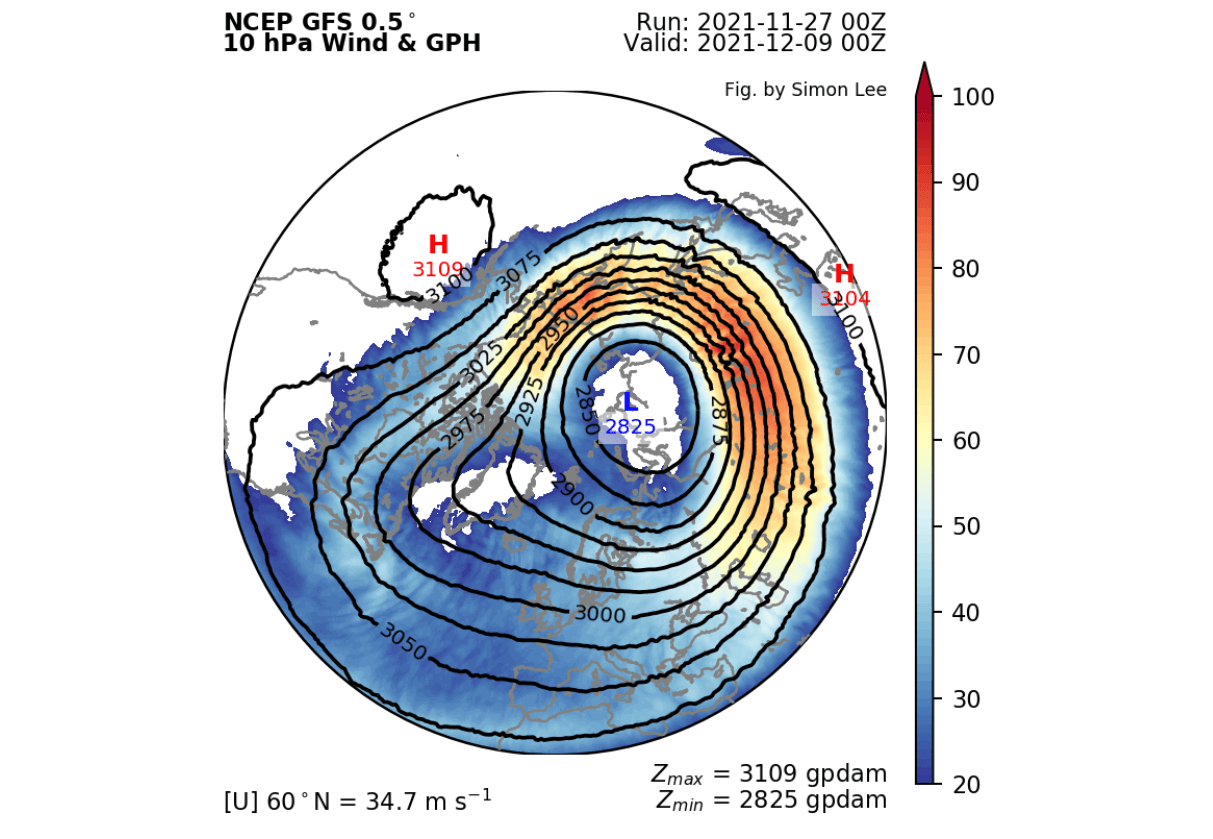
The shift of the core can also be seen in the temperature forecast, which shows the core move over Scandinavia and towards Siberia. The shape is also changed slightly, as it is being pressed on from the Pacific side.
We can also take a look at the vertical pressure profile, to see what are the expected changes from the stratosphere to the lower levels. This image basically shows the pressure anomalies with altitude over the North Hemisphere (40-80°N). We can see a stronger low-pressure area (polar vortex) in the upper stratosphere, extending down, connecting with the lower levels strongest at around 120-180 degrees longitude. That is in Siberia and East Asia region.
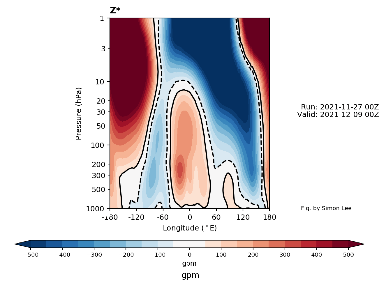
But we see a lack in connection over the Atlantic region, where a high-pressure area sits, and a weak connection to the Canadian part of the lower vortex.
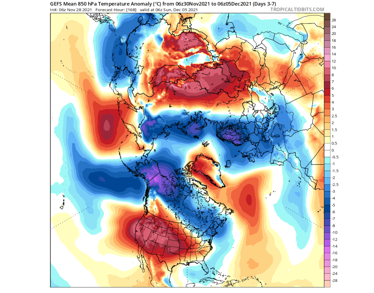
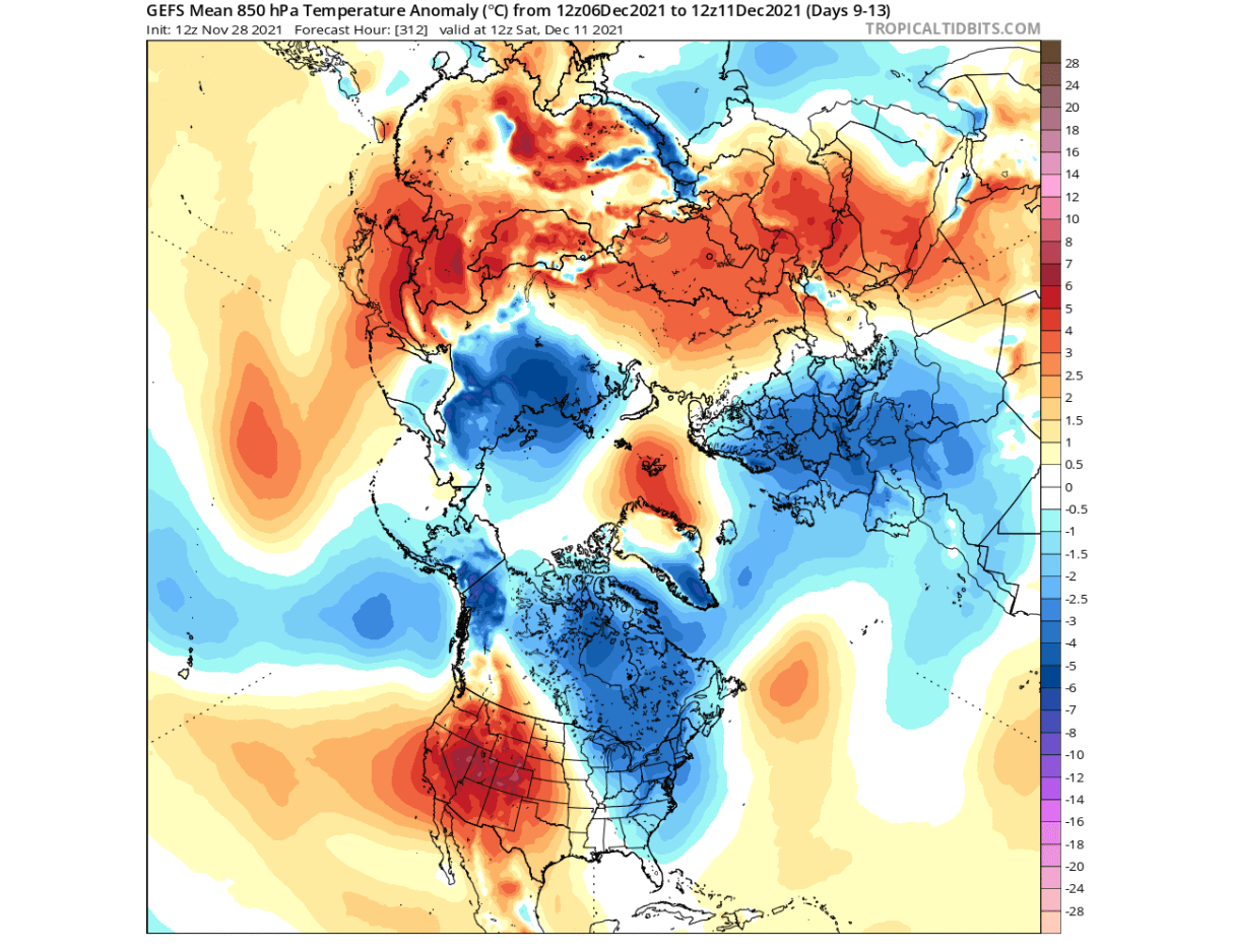
Looking at the 500mb pressure pattern in week 2 of December, we can see that the low-pressure region present from Siberia into East Asia, which is the main connecting point of the stratospheric Polar Vortex. But we can see overall that we have another (stronger) core over Canada and a polar vortex extension (arm) into Europe.
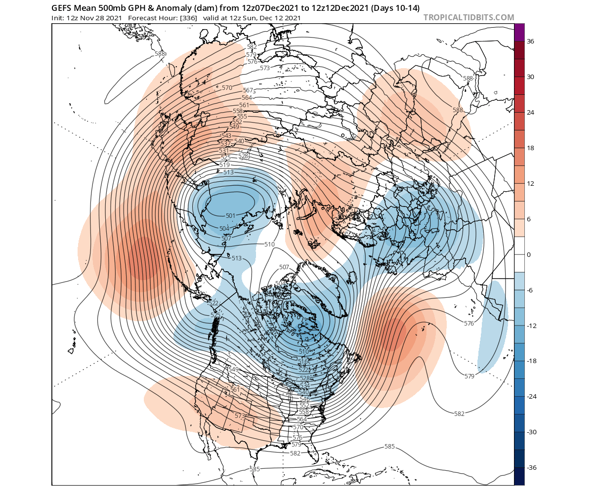
Temperature-wise, we see colder air being more defined to the low-pressure areas. We see a continued trend of colder temperatures over Europe, thanks to the high-pressure system present in the North Atlantic region. Over the United States, warmer than normal temperatures are the trend for now over the west, due to the expanding high-pressure system. But central and eastern regions of the United States are likely to see a cold air event around the middle of next week.
The next map below is special, as it helps us to track the wave activity (energy) around the Northern Hemisphere. It basically shows the heat flux on the border between the troposphere and the stratosphere. But the main takeaway is the very obvious strong wave activity over the North Pacific and Siberia, and the core of the lower stratospheric polar vortex breaking into two units, as seen above.
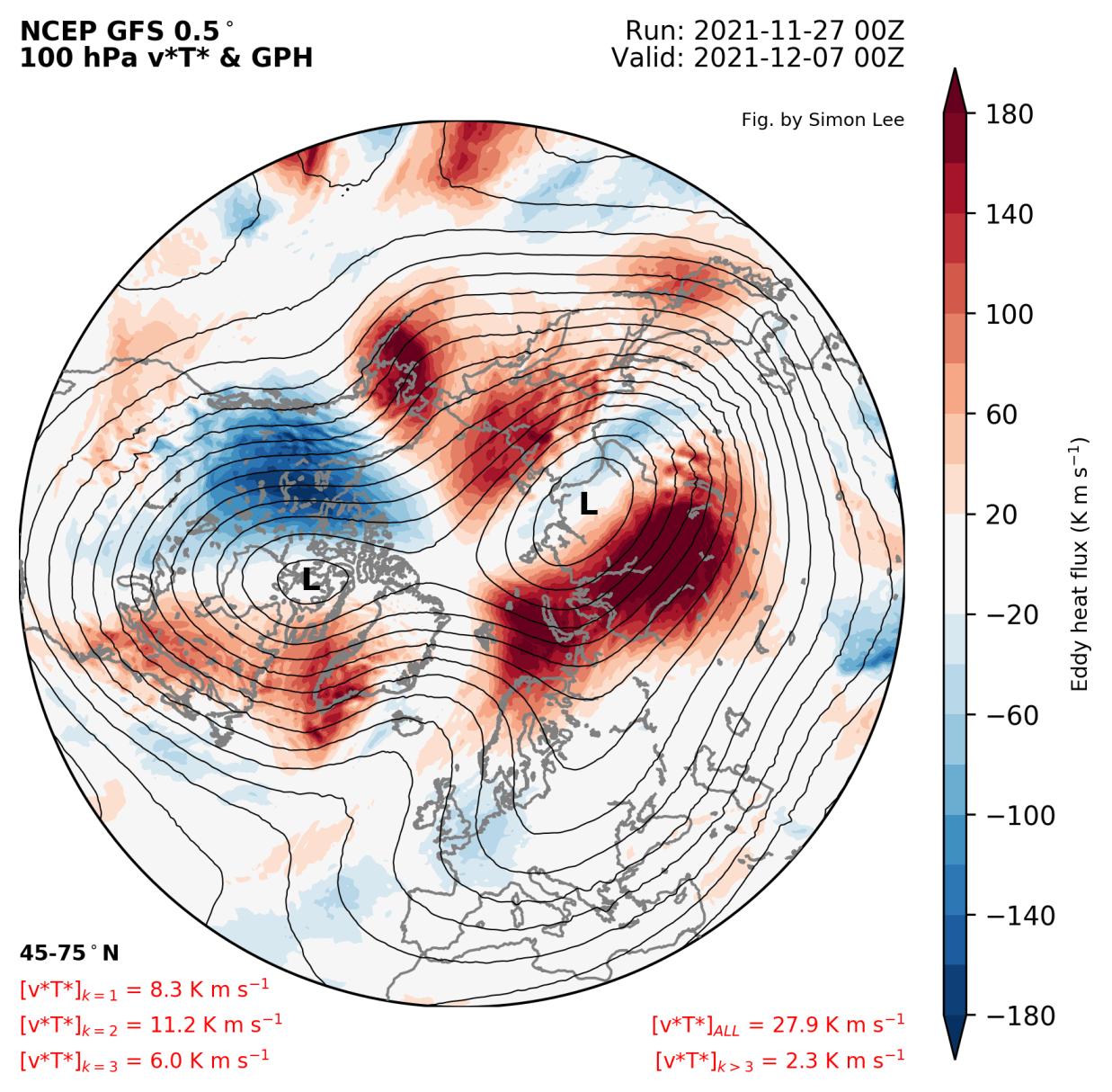
Looking at the state of the polar vortex in the mid-stratosphere towards the mid-month, we can see a fairly large high-pressure system over the North Pacific. This is also a result of the strong wave activity over the North Pacific. The polar vortex is being pressed against, changing its shape from the classical circular to more elliptical.
Temperature-wise in the stratosphere, this means a likely warming wave could emerge in the east-Asia and the Pacific region. The current forecast does indicate some small warming wave trends, but this is a bit far down the range. Tho latest forecasts are getting persistent with this warming wave initiating.
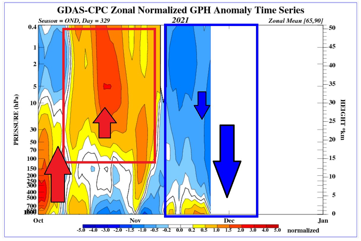
As far as the stratosphere and weather connection goes, there is a special graphic that puts that into a perspective. On the next image below take notice of the high-pressure anomaly rising up from the ground, reaching up into the stratosphere from October into early November.
Low pressure began dominating the polar region later in the month. The forecast now shows lower pressure reaching down from the stratosphere into the lower levels, connecting the two layers more directly. Despite this connection and the pressure dropping over the polar regions, there is enough “resistance” in the pattern below to still allow colder air to reach Europe and the eastern United States at the moment.
But with strong momentum above, a full large-scale long-term winter outbreak is not so likely to appear or to last. If the Polar vortex above in the stratosphere continues to power up, especially with some dynamics coming up that increase the wind speeds, it can get harder for the lower levels to maintain a very disruptive circulation.
ECMWF POLAR VORTEX FORECAST
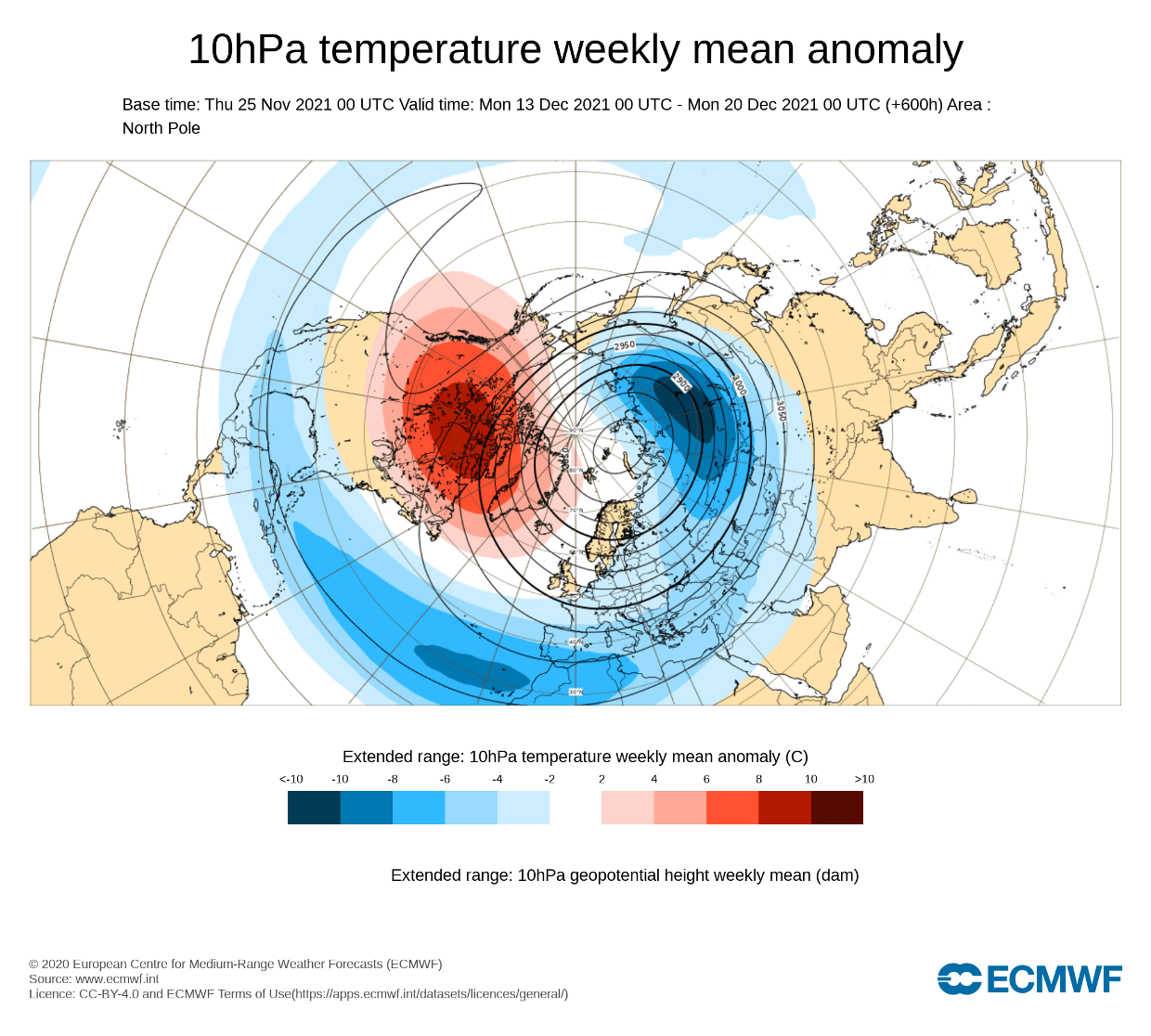
Looking at the extended range forecast from ECMWF, we can actually see trends of new warming waves over the Pacific-Canada region. Below we have an ensemble forecast for mid-December. It shows the temperature anomaly at the 10mb level (30km/18.5miles). The extended forecasts have their limitations, so we are only looking at the trend.
This current trend is definitely a clear sign that the polar vortex is expected to have some sort of disruption attempts in the coming weeks. We will of course monitor the situation closely, as these are titanic forces that have the power to change the course of Winter 2021/2022 if strong enough.
Looking further towards late December, we see the warm signal still present, and a high-pressure area appearing in the North Pacific region. This is the main area to focus on, as this is the usual region from where a high-pressure area in the stratosphere starts to expand and press against the polar vortex.
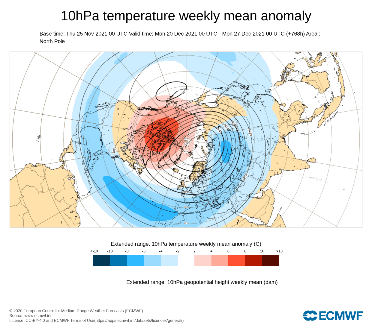
It is hard to say at this point what specific weather effects might be in these scenarios. These stratospheric events and their effects are much more unpredictable than they might seem. The limitation is the model actually getting the surface forecast right, to then being able to add the effects from the stratosphere. At the present time, we can just observe the trends, which show early warming dynamics to appear from the Pacific side of the stratosphere.
Below we have the ECMWFlong-range stratospheric forecast. It shows the wind speed in the stratospheric polar vortex, which is directly related to its strength. A major stratospheric warming event normally features a reversal of the winds in the stratosphere (negative values).
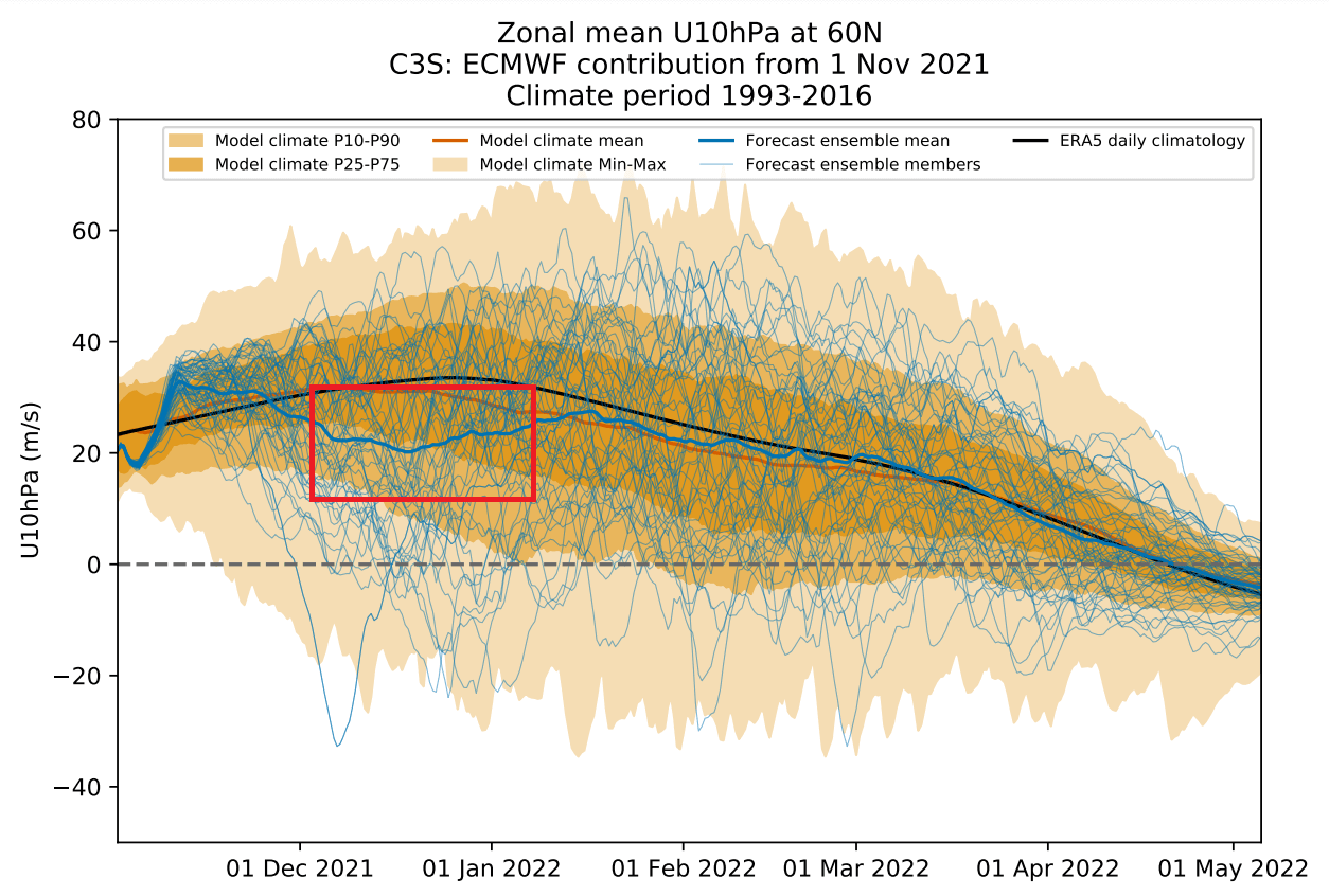
We can see an obvious weakening of the polar vortex in late December and early January 2022. No major polar vortex collapse event is indicated in the main forecast, but this does hint at potential disruption for the polar vortex. We do have some individual calculations going into the negative values (SSW). This basically shows the most-probable window of opportunity for a major stratospheric warming event to occur in this Winter season.
The best example of such an event changing the course of Winter was no further back than last winter. You will see below, how the major stratospheric event unfolded this January, changing the weather patterns across the North Hemisphere in January and February. It was later recognized as the main culprit behind the cold arctic outbreak in the southern United States in late February.
WINTER SEASON STRATOSPHERIC WARMING
A polar vortex collapse is officially named as Sudden Stratospheric Warming event (SSW). It is exactly what the name suggests. It is a sudden temperature rise in the polar stratosphere during the cold season. Warming of the stratosphere means that the polar vortex is weakened, and can also collapse under the rising pressure during the warming event.
The source of the warming usually comes via the energy from the bottom up, as strong weather systems can actually deflect a lot of energy upwards into the stratosphere, disrupting its dynamics.
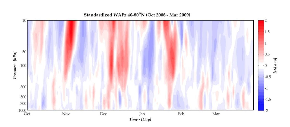
On the image below you can see the vertical wave propagation during the 2008/2009 cold season. It basically shows energy transport in the vertical levels. Notice the red areas, which show the energy moving from the low levels up into the stratosphere, disrupting the circulation. This energy is mainly responsible for creating a warming event.
This creates a chain reaction, which can disrupt the jet stream, creating a high-pressure area over the Arctic circle. That can release the cold arctic air into Europe and the United States. Below we have two SSW examples, from the great SSW analysis site at ESRL/NOAA. The image shows the SSW event during the 1984/1985 and 2008/2009 winter seasons.
The top row shows the stratospheric conditions, with warming anomalies, and a polar vortex split into two parts. The bottom row shows the surface temperature anomalies that followed these events, with the very cold winter in 1985 and cooler weather after the 2009 SSW event.
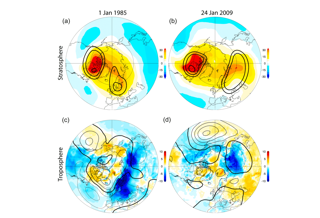
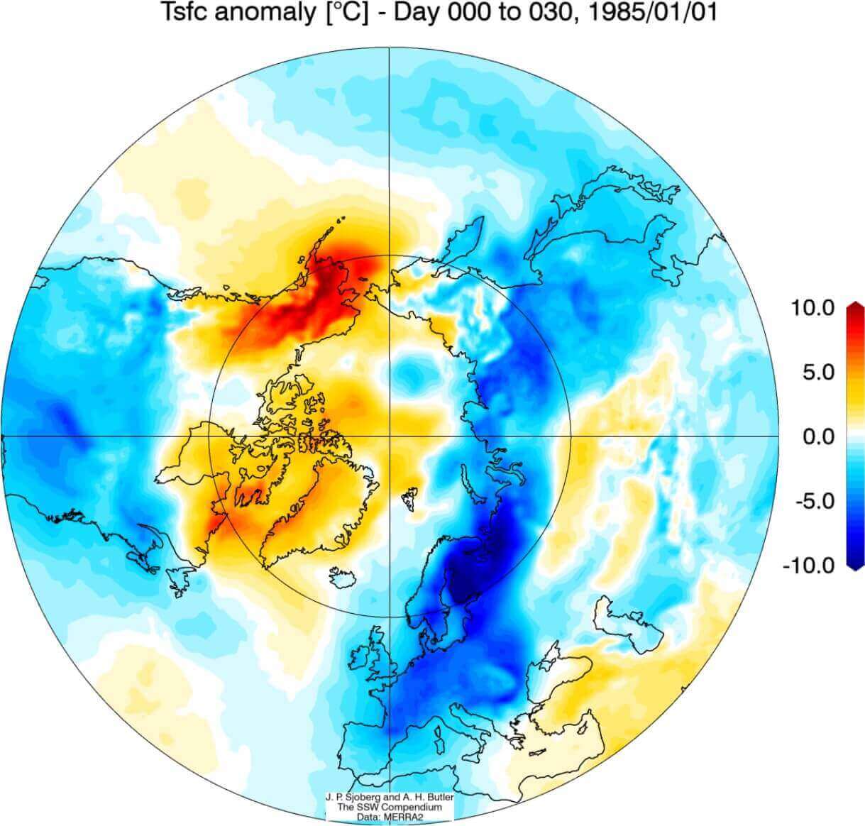
Looking closer at the 1985 warming event, we can see the stratospheric warming (red colors) as it progressed downwards over time. It quite quickly connected to the lower layers of the atmosphere, raising pressure over the North Pole in mid-January and into February. This event helped to release the colder air into western and central Europe and the northern United States that winter.
Below we have the surface temperature anomalies, from 0-30 days after the SSW event in 1985. We can see a very cold signal from northern and central Europe and of course cold in much of the United States. The western polar regions were warmer than normal, under the strong high-pressure system, generated by the stratospheric warming event.
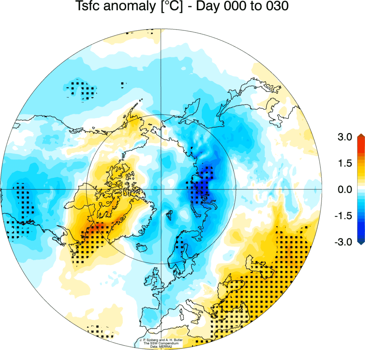
If we combine all Stratospheric Warming events in the past decades and look at the weather 0-30 days following these events, we get an interesting picture.
Below we have the corresponding average temperature 0-30 days after an SSW event. Most of the United States has a colder signal, and also Europe, with the exception of the southeast parts. Note: this is an average picture of many SSW events. Each individual stratospheric warming event is different and does not automatically mean a strong winter pattern by itself.
We can see the average pressure anomalies below, which show the surface pressure rise following the SSW events. Pressure tends to drop over Europe and the western Atlantic. This is a heavily disrupted circulation, that helps to create a free path for colder polar air to move out of the polar regions.
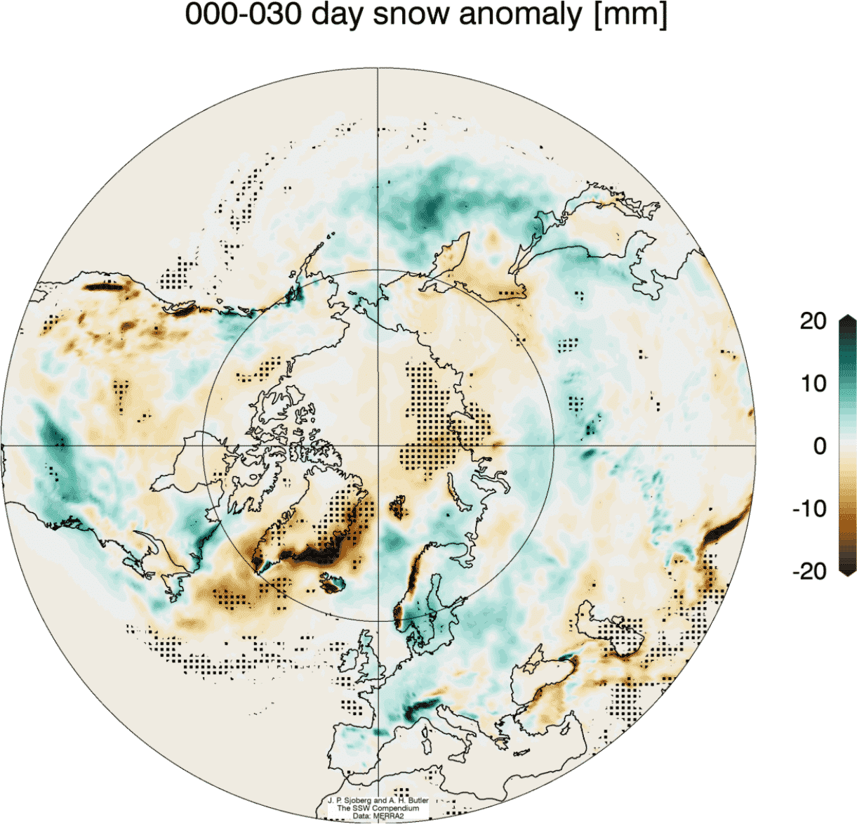
Looking at the snow anomalies below, we can see the above-average snowfall over much of the eastern United States and also Europe. This is a natural response as typically after major stratospheric warming, the colder air has an easier path towards the south and into these regions.
MAJOR STRATOSPHERIC WARMING EVENT – 2021
We have witnessed major stratospheric warming this year, in early January. The whole sequence began in late December, and it changed the weather patterns for the rest of Winter.
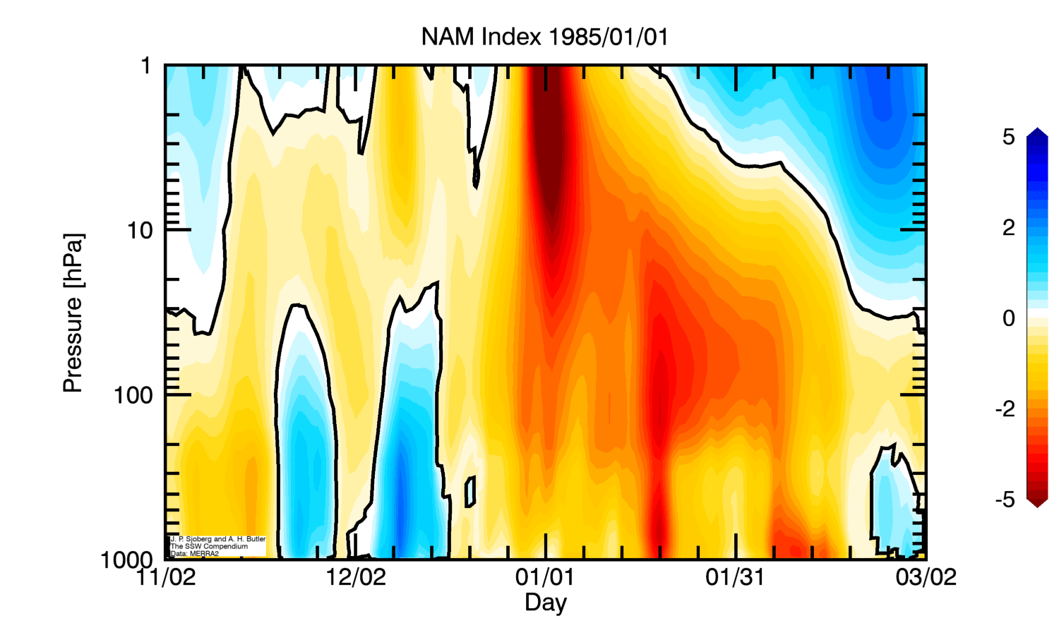
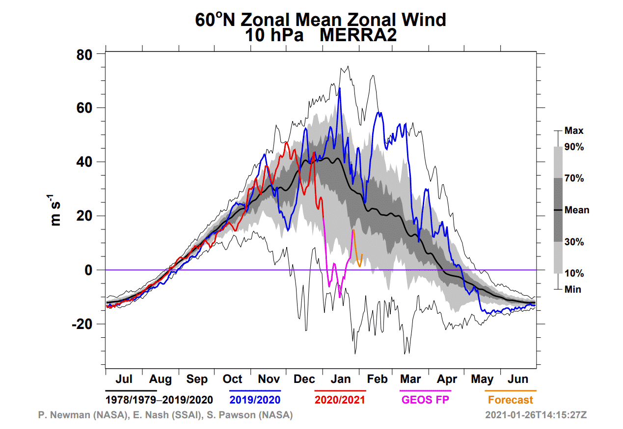
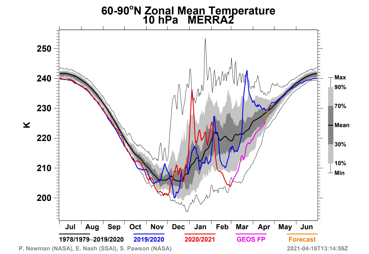
In early December, the polar vortex was quite strong, reaching over 40m/s (90mph) zonal wind speeds. Towards mid-month, and even more in late December, the polar vortex began to weaken. We can see on the graph below how the zonal wind became negative in early January, due to the breakdown of the polar vortex.
The next images below will show you the temperatures at the 10mb level, which is in the middle stratosphere at around 30km/18.5miles altitude. Here, the polar vortex is much more circular in shape, as there is less influence from the terrain and the weather fronts at this high altitude.
In late December, a warming sequence began in the stratosphere, expanding from Europe over into central Asia. It was starting to engulf the outside layers of the polar vortex. The cold-core of the polar vortex was getting more oval in shape, as the pressure was starting to rise in the stratosphere over the North Pacific area and over east Asia.
Just two days later, a strong warming wave reached its peak over Siberia, with maximum temperatures in the wave reaching up to +5°C. In normal conditions, the temperatures here are over 30-40°C lower, so this was a very significant warming wave in development.
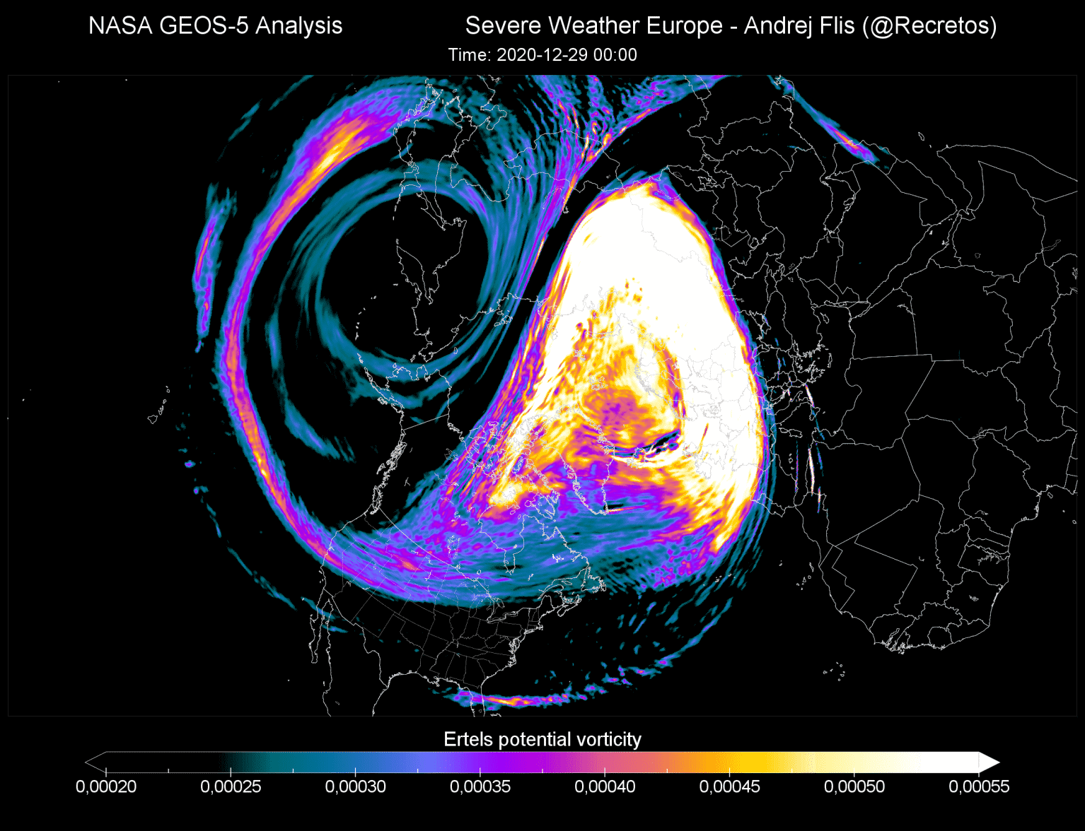
While this was occurring, the actual polar vortex at this altitude (30km/18.5miles) looked more triangular in shape, rather than the usual healthy-circular. The image below shows vorticity, or to simplify, the energy of the polar vortex. We can see it was being drained of energy, by a strong (barely visible) anticyclonic system over the North Pacific and East Asia.
On January 5th, the preliminary date of the Sudden Stratospheric Warming event was marked, as the winds around the polar circle have reversed from westerly to mainly easterly.
The stratospheric warming wave has covered the entire North Pole in the stratosphere, effectively splitting the cold-core of the polar vortex into two parts.
One part of the split polar vortex has moved over North America and one moved over the European sector. At this point, this did not do much to the surface weather directly, as this is at stratospheric altitude. But as you will see, the domino effect has begun, and higher pressure was progressing to the lower levels.
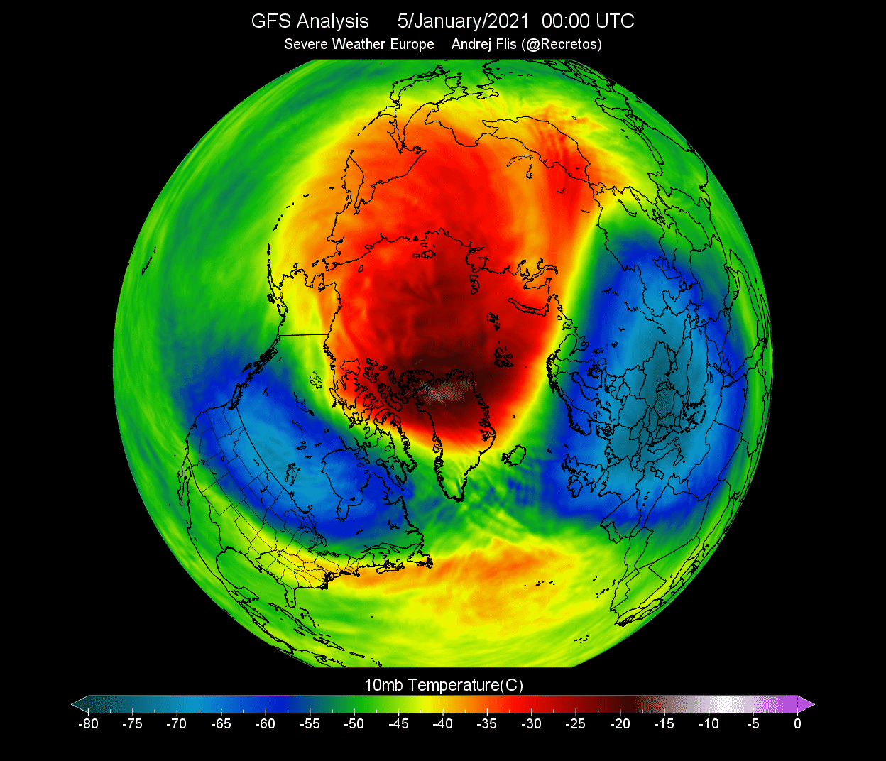
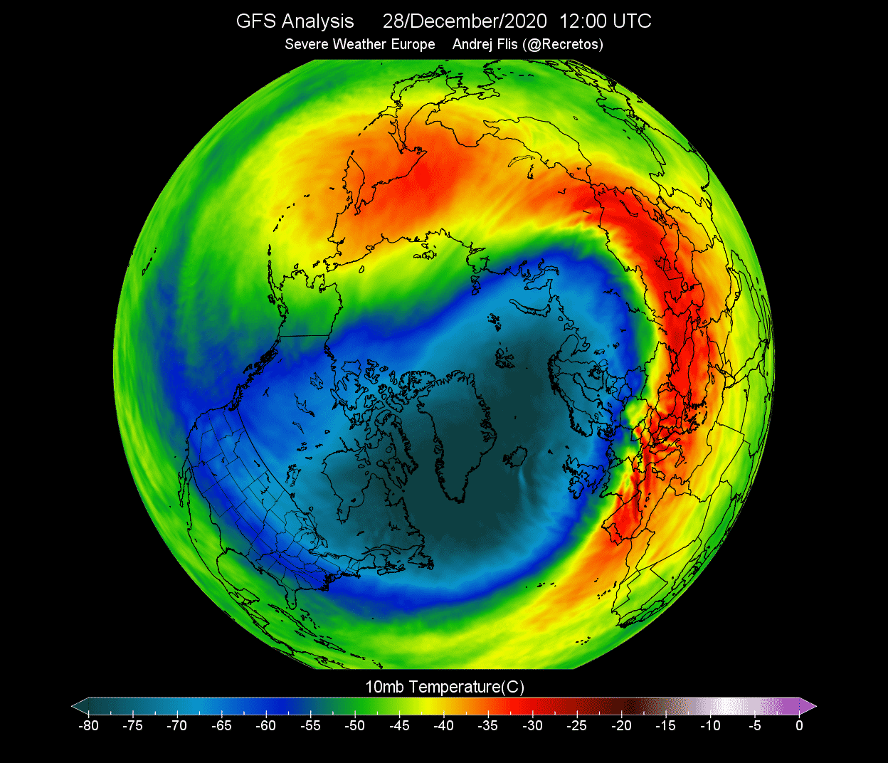
Below we can see the NASA temperature analysis for the polar stratosphere. Notice the large temperature spike at the 10mb (30km) level in early January 2021, caused by this SSW event. This shows quite a strong warming event, with temperatures continuing to stay above normal all the way into early February.
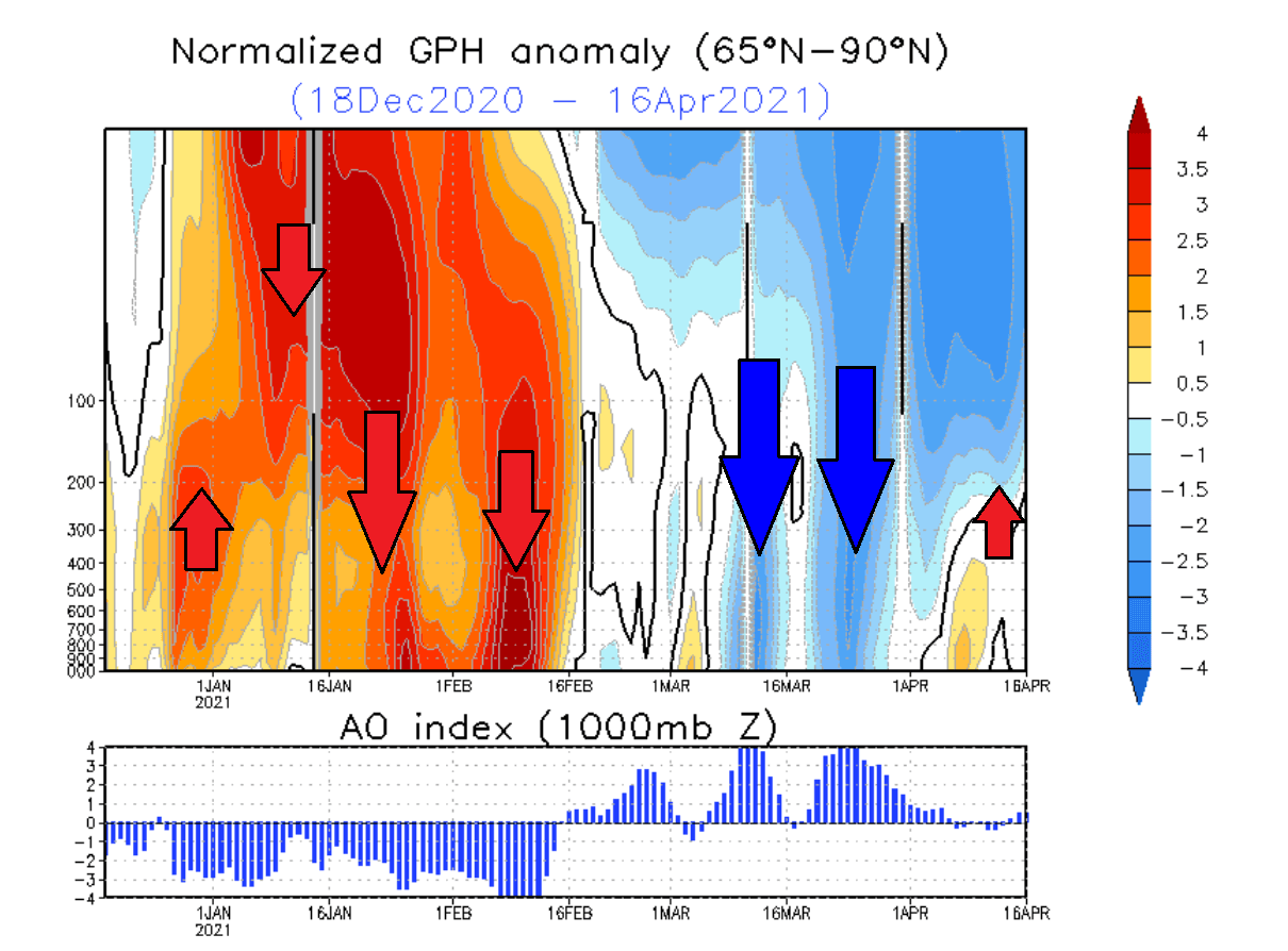
When trying to find a connection between the stratosphere and the winter weather, it helps to have more specialized images at hand. Especially one that combines altitude and time.
The image below shows an atmospheric pressure index. Negative values indicate lower pressure (blue colors) and positive values indicate higher pressure (red colors). We can see the lower half of the atmosphere from the ground up to the middle stratosphere (~30km/18.5miles) in early 2021.
You can see strong positive values in the stratosphere in early January, associated with the pressure rise during the stratospheric warming event. The high-pressure influence was slowly descending over time, reaching the lower levels by mid to late January. This persisted well into February, influencing the weather circulation even when the stratospheric warming was already over.
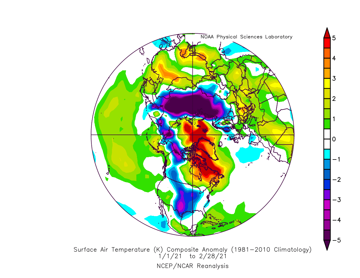
A strong high-pressure system over the Arctic can heavily disrupt the weather circulation and can unlock the cold air from the Arctic regions towards the mid-latitudes The image below shows the surface temperature anomalies in January-February 2021 period. Warmer than normal temperatures were present under the high pressure over the polar regions. Very cold Arctic air was pushed out heavily into Siberia. Some colder air also got transported into western Canada and the south-central United States, resulting in the strong Texas February cold air outbreak.
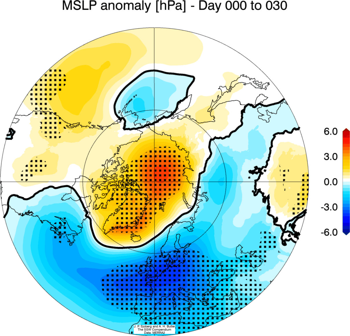
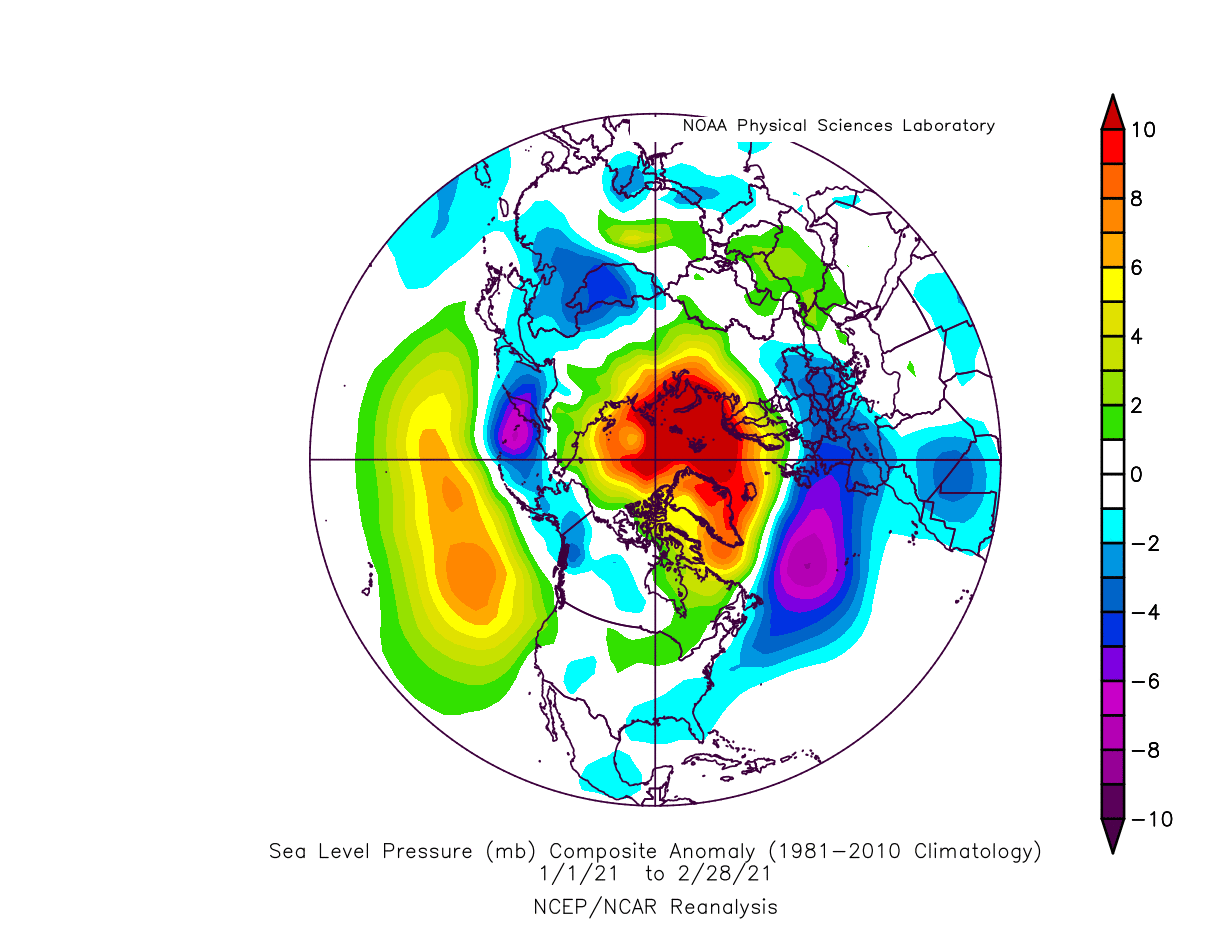
We also produced an analysis of the January-February 2021 winter period. It shows the sea level pressure anomaly. You can see a strong high-pressure system present over the North Pole. This dominant high-pressure system originated from the stratospheric warming event and the polar vortex collapse, changing the circulation and dispersing the colder air towards the southern regions.
We will release regular weekly and monthly updates for the upcoming winter season as fresh forecasts and data are available. So make sure to bookmark our page. Also, if you have seen this article in the Google App (Discover) feed, click the like button (♥) there to see more of our forecasts and our latest articles on weather and nature in general.
SEE ALSO: