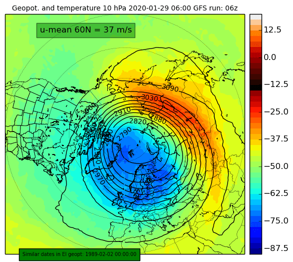
The polar vortex usually reaches its peak strength in late December and early January. As we head further into January and February, the Polar Vortex starts to slowly lose its strength, as the angle of the Sun is increasing and warming the upper atmospheric polar regions. That means the Polar Vortex is not able to defend against upcoming attacks, which are coming in two waves.
The animation below shows the stratospheric polar vortex forecast, at 5mb level (~35km altitude), where we can see a new double warming phase developing. But let’s go into more details below.
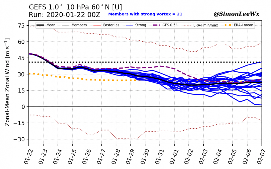
The 16-day ensemble forecast shows the strength of the polar night jet, weakening over time. It is currently around 50m/s, which is considered a strong polar vortex. The “standard” is to measure the speed of the stratospheric polar jet stream at 10mb level (~28-30 km altitude), at 60° North latitude (along the polar circle) which we see on the graphic. A slow reduction in strength of the polar vortex is typical for late January, as the upper levels of the atmosphere are slowly starting to warm again, as the angle of the Sun is starting to increase over the polar regions. Polar vortex gains strength and power when the upper levels are cold, as the temperature difference with lower latitudes drives the strong stratospheric jet stream. As the upper polar regions start to warm again, the contrast starts to reduce and the strength of the polar vortex reduces over time.
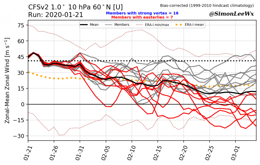
The longer-range forecast shows the continuation of the trend, further reducing the strength of the strato-jet, some even all the way down into negative values (jet reversal), which would likely mean the end of the Polar vortex for this winter.
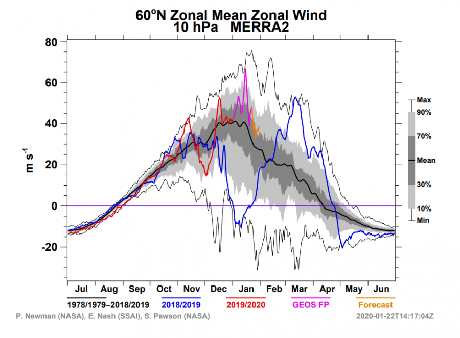
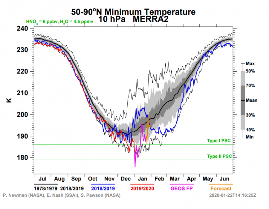
The stratospheric jet and temperature analysis from NASA/GEOS, shows the progression this season and also shows the climatological average. We can see the peak polar vortex strength for at least 40 years now, is in December and early January. Peak strength is usually when we have the strongest stratospheric jet stream (zonal wind) speed and lowest temperatures in the core. We can also nicely see the maximum and minimum values recorded in the past 40 years, which gives a very nice context. The polar vortex will eventually reach its demise, but this upcoming warming could speed up the process and try to influence at least partial, but detectable, circulation changes in the troposphere at later periods. On the temperature graph, we can see that this season, we likely achieved the lowest temperature at 10mb level in the past 40 years. You can read more about that event in our article: Coldest 10mb temperature recorded.
So, what exactly is about to happen in the stratosphere with the polar vortex? Currently, the vortex is in a pretty good shape, with a relatively cold-core and a wide wind field, and is connected with the troposphere (lower atmosphere where all our weather is), helping to maintain the current circulation pattern.
In around a week, a temperature wave is expected to enter the surf zone of the polar vortex, from the top of the stratosphere downwards. The warming is set to appear over the Siberian and E Asian sector.
Around day 10-12, this first warming wave is likely to peak, but what is also more important is the development of a polar high (anti-vortex) over North Pacific and Canada. This is a geopotential wave 1 pattern. This, combined with the temperature wave is what will weaken the vortex, which at this point is not in a point to defend heavily, as it is running out of time.
Around day 16, the first temperature wave is easing off, but a new one is indicated to start from the same Siberian sector. We can see the core of the vortex is not as cold as in the beginning, with the shape also implicating a wave 2 pattern. This puts the vortex in a quite uncomfortable position, and if this were to materialize, it is not likely the polar vortex could ever recover to previous strength this late into the season.
The multi-model forecast shows the reduction of the strength of the polar vortex, as the temperature starts to rise with the warming wave.
Now, as all would like to know, what does this mean for our weather. The troposphere and stratosphere are quite heavily coupled at the present time. If we start to disrupt the stratospheric polar vortex, it is possible we can disconnect the tropospheric and stratospheric circulation pattern briefly. But the troposphere is currently in a pretty strong circulation pattern which can further drive itself, even if we actually do disrupt and disconnect the stratospheric vortex. Given the time-frame, if a heavy disruption occurs towards late February, that could have implications for the setup of the circulation pattern in the spring. We do have to add that the forecasts above are based on the GFS/GEFS model suite, so we also need more support for this scenario from other models, especially the ECMWF. Below we can see the week 3/4 forecast from the CFSv2 model, which does not seem to indicate any change in circulation for now. But that can change quite rapidly. The pattern, however, is supportive of colder air transport into E Canada and parts of the eastern United States. So the models currently do not yet see any feedback from the stratosphere in the next 2-3 weeks. But that is to be expected since it usually takes some time for the effects from the stratospheric circulation changes to infiltrate downwards into the troposphere. The “best” case scenario would be rising pressure over the North Atlantic later in February and early March, which would increase the chance of early spring cold shots into Europe and the east USA.
We will keep you updated on any important further development, but while you wait for more updates, don’t miss our latest long-range forecast for Spring 2020, where we also mentioned the unpredictable factor of the stratospheric changes:
