Friday will bring one of Ireland’s most violent Atlantic storms in decades. Destructive winds, significant waves, and extremely low surface pressure are forecast as a bomb cyclone grazes into Western Europe. Storm Éowyn will bring winds of nearly 200 km/h to the western coast of Ireland.
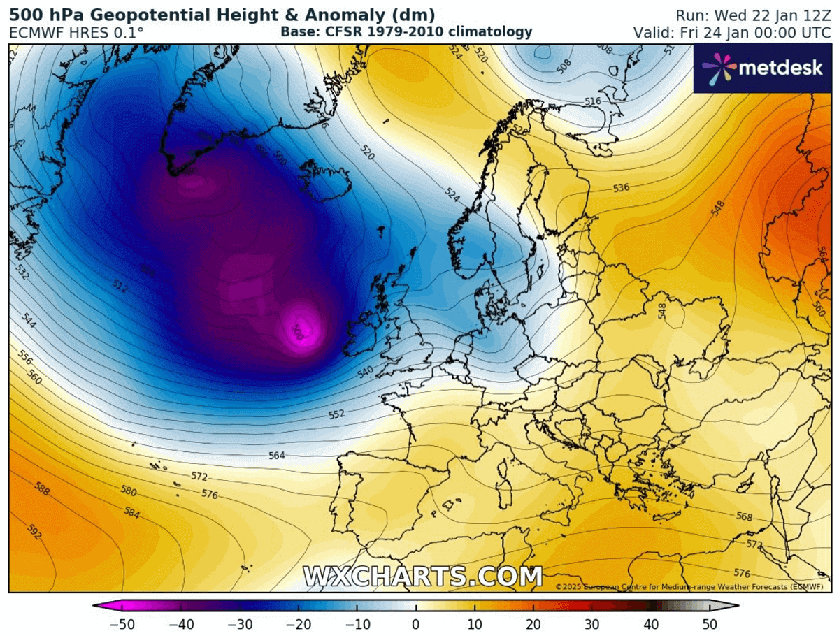
Thanks to disruptions in the Polar Vortex’s aloft, its deep southern lobe is emerging from Canada into the North Atlantic, allowing the explosive development of frontal waves and deep surface lows towards Western Europe.
The following posts are live tracker updates as the evolution unfolds. The last update is always at the top of the article.
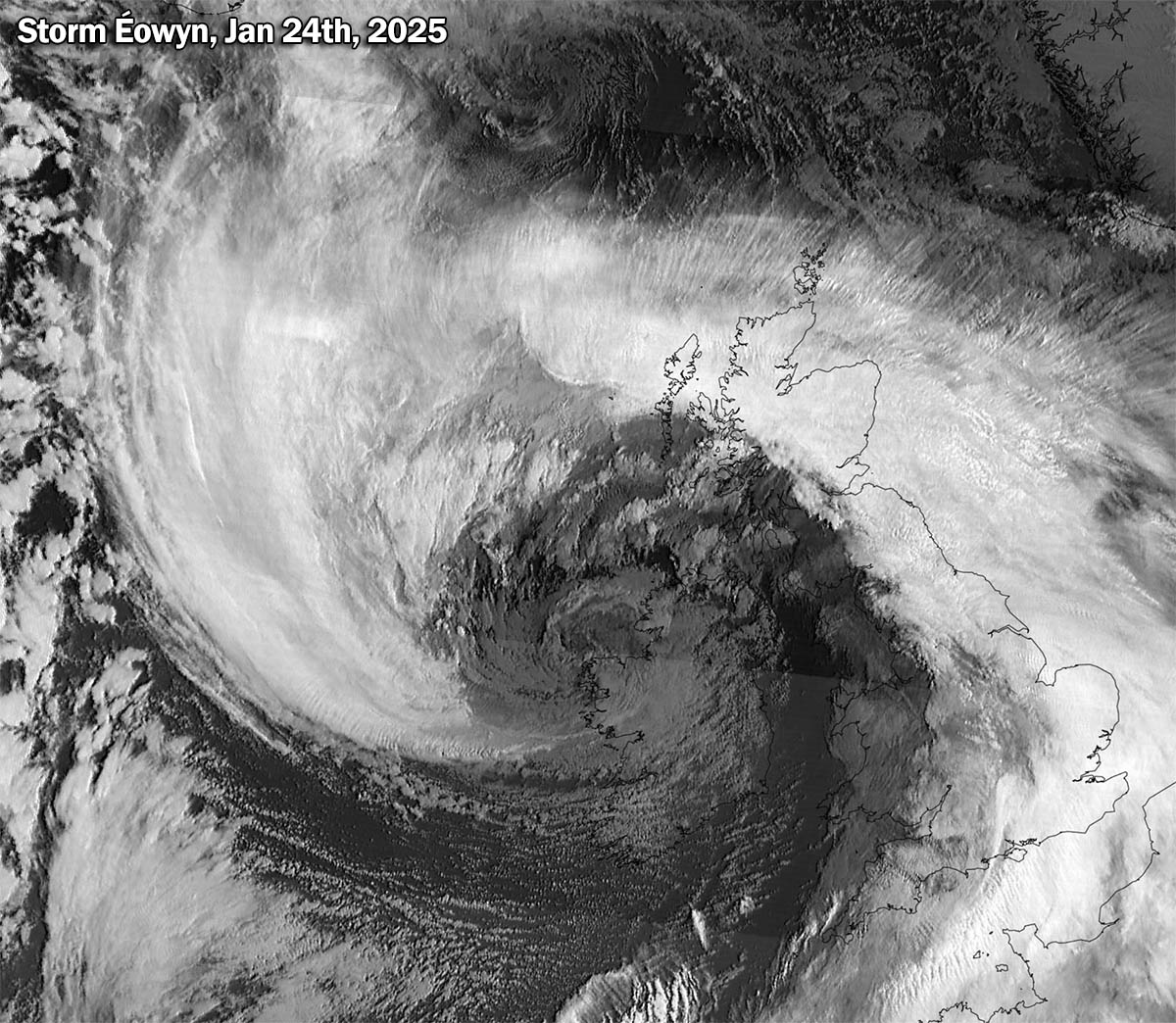
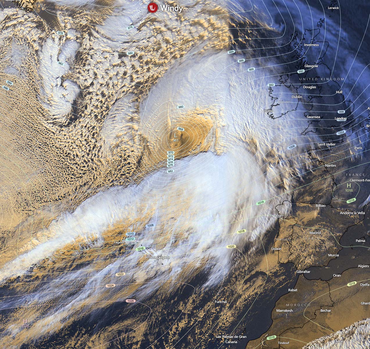
Airmass satellite animation of storm Éowyn evolution over the last 36 hours
Update: Jan 24th, 20:00 UTC
Here is the gif animation of the historic storm Éowyn from its birth in the North Atlantic throughout the sting jet phenomenon over Ireland and gradual weakening while moving north of the UK.
The most intense impact of violent, hurricane-force wind gusts was over Ireland and Scotland.
Mace Head weather station sets Ireland’s new wind gust record
Update: Jan 24th, 15:30 UTC
As expected, the violent impact of hurricane winds, associated with the sting jet phenomenon wind maximum, has blasted Ireland and Scotland in the morning hours. The highest wind gusts were reported from western Ireland, where the weather station Mace Head recorded 184 km/h peak gust, with a sustained 10min wind speed of 135 km/h.
This breaks the highest wind gust record of 182 km/h, set in 1945 at Foynes Co. Limerick, Ireland.
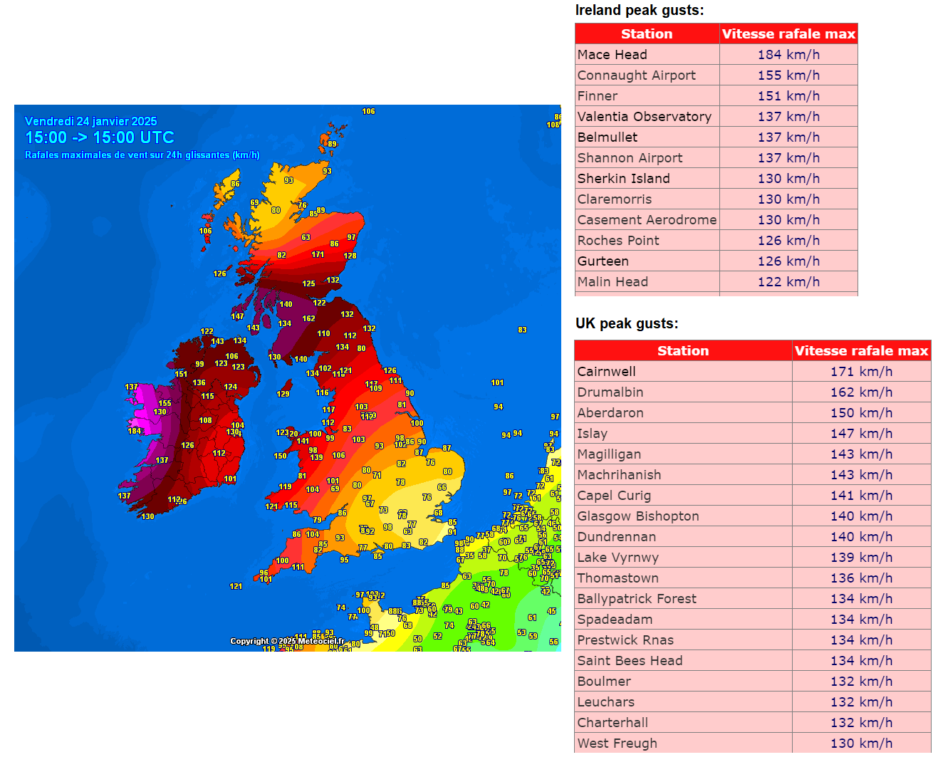
As seen in the attached image above, multiple weather stations reported hurricane-force wind gusts as follows:
- 184 km/h – at Mace Head
- 155 km/h – at Connaught airport
- 151 km/h – at Finner
- 137 km/h – at Valentia Observatory, Belmullet, and Shannon airport
Violent wind gusts were also reported from the UK across Northern Ireland, northern England, and Scotland.
- 216,8 km/h – at Cairnwell / Cairngorms
- 162 km/h – at Drumalbin
- 150 km/h – at Aberdaron
- 147 km/h – at Islay

Éowyn is now gradually weakening while moving towards the north.
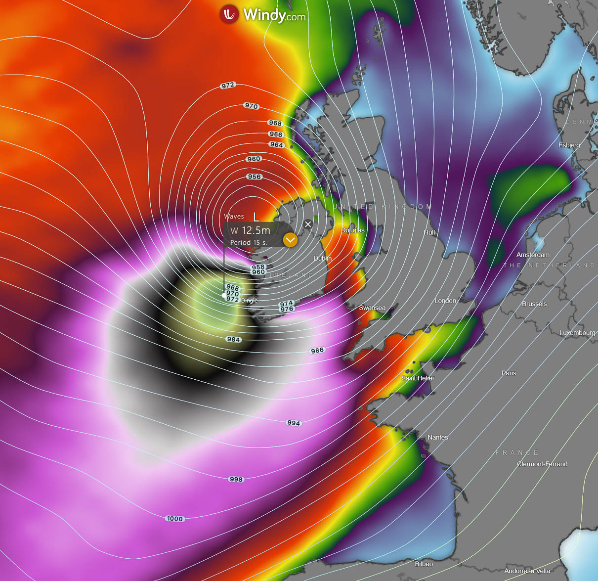
Surface pressure analysis sequence
Update: Jan 24th, 13:00 UTC
This is the 9-hour sequence of surface pressure across Western Europe, from 4 UTC when Éowyn was west of Ireland to 13 UTC when it was gradually departing northern Scotland.
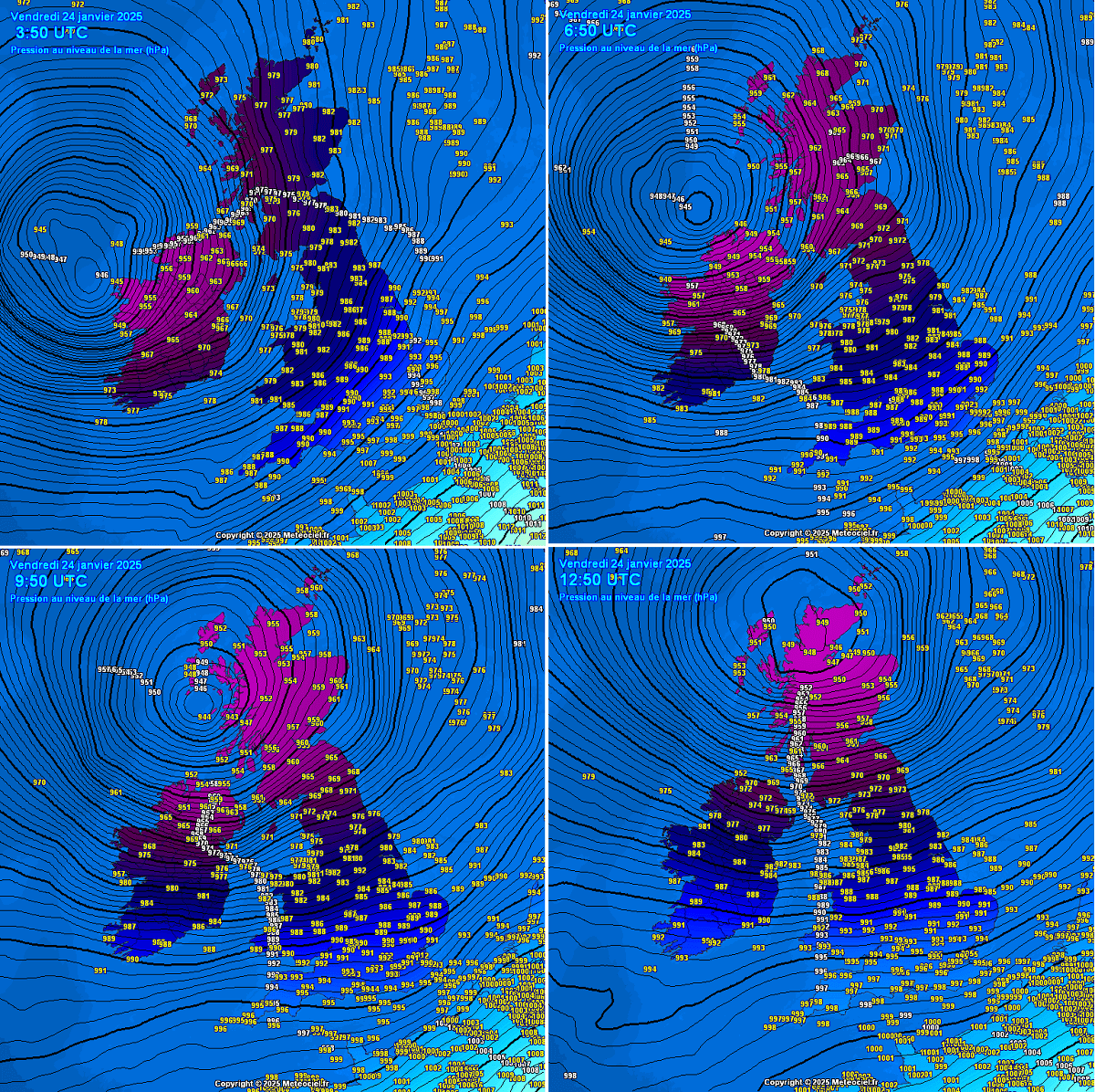
The minimum central pressure was estimated from 942 to 944 mbar when the storm matured over the Outer Hebrides, Scotland. The most violent winds occur where isobars (lines connecting the same surface pressure) are close together, meaning the pressure gradient is very strong.
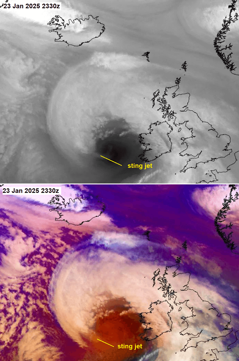
Awe-inspiring satellite presentation of a Sting jet
Update: Jan 24th, 05:30 UTC
The latest Infrared, Airmass, and Water Vapor satellite imagery reveal a textbook Sting jet appearance, with a well-defined stinger/tail where the more violent winds are present.

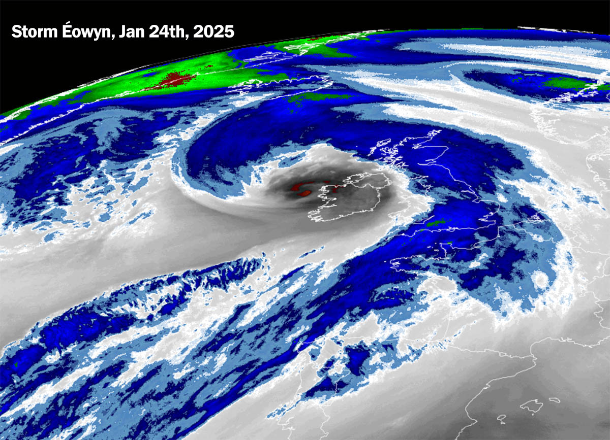
Powerful winds within the sting jet descend towards the surface and intensify further as the air parcels dry out. These winds graze through the layers as the air evaporates on the nose of this descending jet.
Thus, the evaporative cooling process creates a clear path through the precipitation, making the air much denser within the jet. Leading to extremely intense wind gusts that reach more than 160 km/h.

The impact of hurricane-force winds on the western Irish coast is imminent.
Learn about Sting Jet and why it brings such violent winds
Update: Jan 24th, 00:20 UTC
Sting jet brings the most powerful and destructive winds inside the mid-latitude Atlantic storms; peak gusts could reach up to 200 km/h. This is what we are seeing with tonight’s storm.
You can learn more about them here: What is a Sting Jet?
Sting jet phenomenon appearance on the satellite
Update: Jan 24th, 00:00 UTC
Both infrared, airmass, and water vapor satellites indicate that a sting jet phenomenon has formed inside the core of Éowyn.
Extreme pressure drops observed on Irish buoy data
Update: Jan 24th, 23:00 UTC
Recent observations from the Irish meteorological service Met Eireann oceanographic buoy M6 indicate that the pressure that falls near the core of Éowyn is very impressive. The data reveals that the pressure drop within the last 10 hours is 49 mbar – more than double the criteria for a bomb cyclone (24 mbar pressure drop in 24 hours).
In addition, the last 6 hours also reveal that the pressure drop was 38 mbar in this interval. This means that the average hourly pressure drop was 6.3 mbar, which is very high for so long.
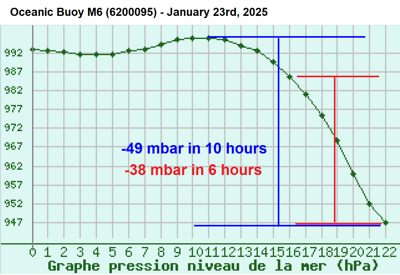
If one would extrapolate this to 24 hours, this would mean a pressure change of 152 mbar/24h. Indeed, it is physically impossible since the deepest part of the storm usually lasts up to around 12 hours, but it does show how *extreme* the pressure is dropping.
Remember, the bomb cyclone criteria is 24 mbar in 24 hours, which is 6 times faster!
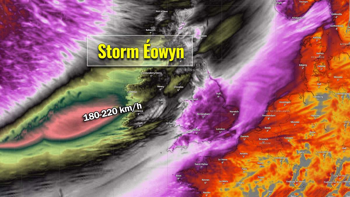
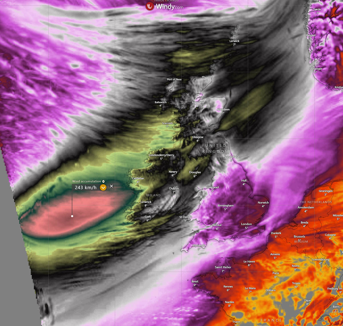
The latest wind forecast confirms violent hurricane gusts are expected
Update: Jan 23rd, 17:00 UTC
Here is the latest UKV weather model forecast for wind gust accumulation over the next 24 hours. Storm Éowyn will have a historic impact on western Ireland early Friday morning.
Peak wind gusts will exceed 180 km/h and could reach around 200 km/h locally along the western coasts and isles.
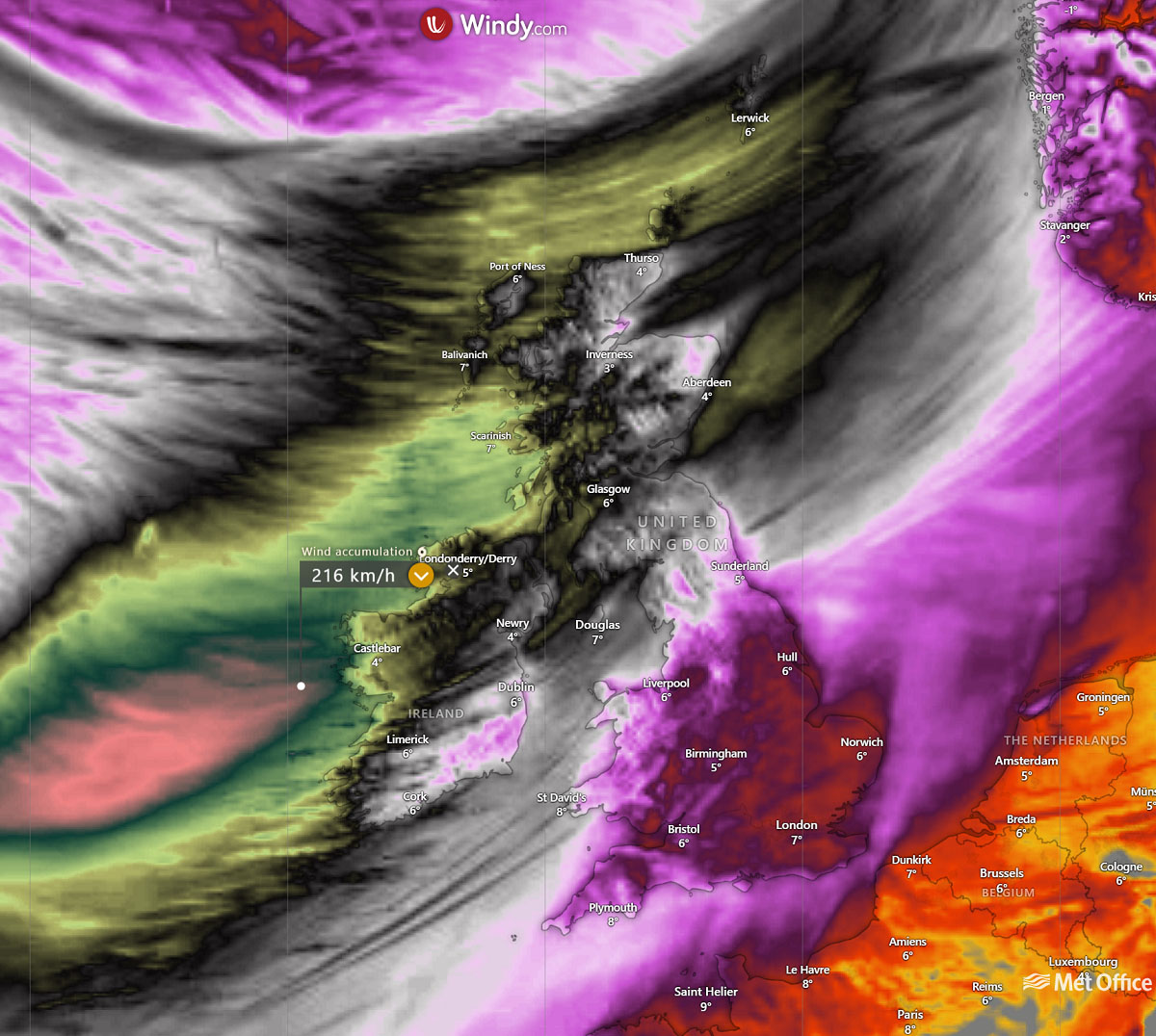
The storm will gradually move northeast across western Scotland on Friday during the day.
Storm Éowyn’s explosive intensification underway
Update: Jan 23rd, 15:30 UTC
The bombogenesis is underway with Éowyn this afternoon, where satellites reveal an impressive, extensive frontal system with a pronounced cyclone structure.
The pressure is falling at extremely rapid rates, with more than five mbar per hour since this morning. As of 12 UTC on January 23rd, the central pressure was analyzed at 965 mbar by the NOAA Ocean Prediction Center (OPC).
As we can see from the following 12z analysis, hurricane-force winds are developing, and further rapid intensification is expected until storm Éowyn reaches Ireland on Friday morning.

The pressure is forecast to deepen for another 25-30 mbar to around 935 mbar when its core makes landfall in western Ireland.
On Thursday night into Friday, a bomb cyclone Éowyn will be fast-moving across the North Atlantic while undergoing rapid intensification, with pressure falls of nearly 50 mbar in 24 hours. The storm will generate extreme hurricane-force winds and significant wave heights.
Status RED – WIND WARNING – has been issued by Irish meteorological service Met Eireann for the country, as gale-to-storm force southerly winds becoming westerly will bring severe, damaging, and destructive gusts on Friday. A list of all active red warnings is seen below:
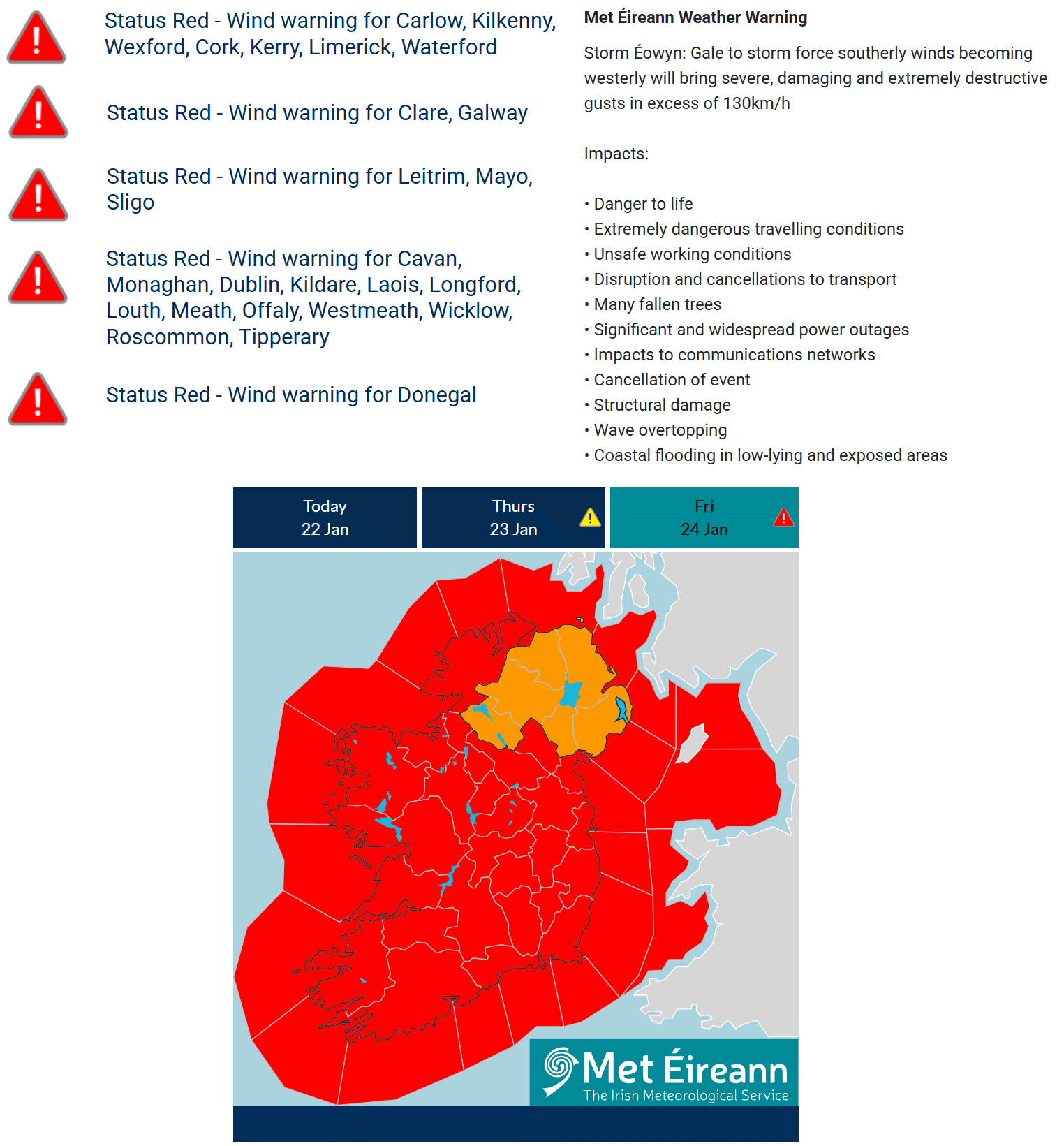
- Status Red – Wind warning for Carlow, Kilkenny, Wexford, Cork, Kerry, Limerick, Waterford
- Status Red – Wind warning for Clare, Galway
- Status Red – Wind warning for Leitrim, Mayo, Sligo
- Status Red – Wind warning for Cavan, Monaghan, Dublin, Kildare, Laois, Longford, Louth, Meath, Offaly, Westmeath, Wicklow, Roscommon, Tipperary
- Status Red – Wind warning for Donegal
This is a HIGH RISK for dangerous weather conditions from early Friday morning and during the day for Ireland, Northern Ireland, and Scotland.
Let’s examine the details of the evolution of weather patterns that led to the development of the powerful storm Éowyn.
Explosive development of Atlantic storm Éowyn, violent bomb cyclone heads for Ireland on Friday
As discussed earlier, the impact of the deep southern lobe of the Polar Vortex moving over North America will also drag Arctic air mass into the North Atlantic. On Thursday, a deep upper-level wave forms, leading to an explosive surface cyclogenesis following the interaction of frigid upper levels and warmer oceans.
A deep cyclone rapidly forming at the surface is known as bombogenesis*, which happens a few times yearly in the North Atlantic.
*Note: Bombogenesis is a meteorological term when the mid-latitude storm undergoes a rapid intensification with at least 24 mbar of central pressure drop in 24 hours.
Storm Éowyn will be a bomb cyclone with the extreme intensification of its wind field and central pressure falls. The central pressure is forecast to drop from nearly 990 mbar on Thursday at 12 UTC to around 935 mbar when it reaches the west Irish coast on Friday at 6 UTC. This is a drop of more than 50 mbar in 18-24 hours.

A rapidly deepening low-pressure system is forecast to track across Ireland to the northern UK Thursday night into Friday. It will continue deepening and expanding in size and effects while grazing towards the northeast into western Scotland Friday morning.
Extreme pressure falls will lead to heavy precipitation and violent winds. Some snow will also be possible before the warmer air mass spreads from the southwest Friday early morning, with the highest chances and amounts over Scotland.
The following forecast chart represents the position of the Éowyn on Thursday evening (left chart) and Friday morning (right chart). We can see a textbook frontal system with a sharp cold front moving through, followed by violent winds and maritime airmass in its wake.
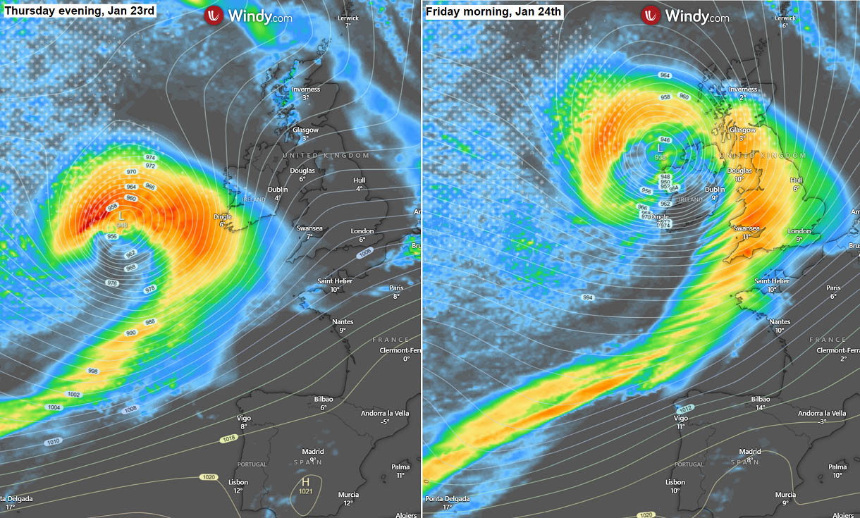
Extremely severe winds are expected to develop across Ireland, Northern Ireland, and Scotland. There is a high risk of destructive wind gusts and significant travel disruptions. A pressure this deep creates intense gradients, which leads to violent winds.
Before reaching Western Europe, the most intense winds will be over the open Atlantic. Then, damaging severe winds will blast into the coastal areas and be violent in higher elevations.
Peak wind gusts are likely to reach 150-180 km/h (90-110 mph), potentially reaching 200 km/h (125 mph) near the western coast of Ireland early Friday morning.
High seas with significant wave heights are also expected. The extensive system will develop a high swell, pushing sea waves higher than 12 meters (40+ ft) along the coast of southwestern Ireland.
On Friday, high waves will also affect the coasts of western and southern Ireland, southwestern England, western Scotland (Outer Hebrides), and northwestern France (Brittany).
Conditions will gradually improve late Friday afternoon when the storm fully matures over the UK and begins weakening while moving towards the north.
Over the weekend, additional storms are expected to form over the North Atlantic and reach Ireland and the UK on Sunday and Monday. Although less intense than Éowyn, they will bring severe winds across most of the Western Europe.
Stay alert for hazardous weather conditions from Thursday evening through Friday. Destructive winds and significant waves are expected on the western coasts of Ireland.
Wxcharts, Windy, and Pivotalweather provided images used in this article.
See also:
Initial forecast: Multiple intense Atlantic storms will blast into Ireland and the UK next weekend