Global weather is constantly in motion. The Southern Hemisphere is currently nearing the end of its Winter season, and strong weather patterns will initiate a warming event in the Stratosphere above the South Pole. These events are rare, but powerful, having historically been strong enough to affect the entire globe.
These stratospheric warming events pack a lot of energy and can effect the entire hemisphere. We experienced that first hand this year, when a strong stratospheric warming event in January altered the weather patterns for several weeks over North America and Europe.
Southern Hemisphere does not experience these winter stratospheric warming events so often, with only a few known events in the past decades.
But just two years ago, in 2019, there was a significant stratospheric warming event over the South Pole. It was so strong, that it had a measurable effect on the Thermosphere and the Ionosphere over the United States and Europe. So we always take notice of what is happening over the Southern Hemisphere, as the Weather and the atmosphere truly are connected globaly.
WINTER POLAR VORTEX
But first, we need to understand where this strong dynamics are taking place, and how can they affect our weather. We will quickly take a look at the stratosphere and the Polar Vortex, as they are often a key player for Winter weather on the Northern and Southern Hemisphere.
All of the clouds (and the weather that we feel) are found in the lowest layer of the atmosphere called the troposphere. It reaches up to around 8 km (5 miles) altitude over the polar regions and up to around 14-16 km (9-10 miles) over the tropics.
Above it, we have a much deeper layer called the stratosphere. It is a very dry layer, around 30km thick. This is where we can find the famous ozone layer. You can see the layers of the atmosphere on the image below, with the troposphere on the bottom and the Stratosphere with the ozone layer above it.
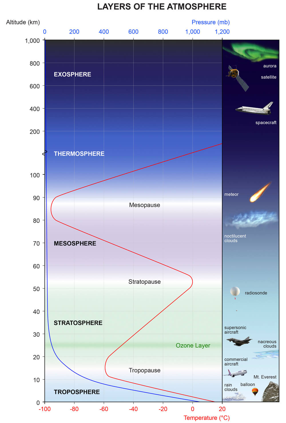
When you usually hear people talk about the polar vortex and its influence, 90% of the time they mean the higher altitude stratospheric part. The stratospheric polar vortex is spinning high above our weather (but strongly connected), having a major role in the developing winter weather patterns across the entire Northern Hemisphere.
Every year as we head into Fall, the polar regions start to cool down. But the atmosphere further south is still relatively warm as it continues to receive energy from the Sun. This temperature difference causes the pressure to start dropping over the North Pole.
As the temperature and pressure drop over the pole and the temperature difference towards the south increases, a large low-pressure (cyclonic) area will start to intensify across the Northern Hemisphere. The same process happens in the stratosphere, creating a large anti-clockwise spinning area.
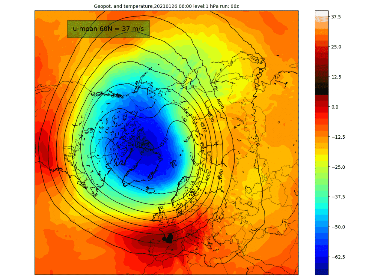
The image below shows a typical example of the Polar Vortex at around 46km altitude (1mb level) near the top of the stratosphere. It is essentially like a large cyclone, but covering the entire hemisphere. It is strongly present at all levels, from the ground up, but in different shapes.
Below we have an image that shows the polar vortex at different altitudes. The closer to the ground we get (left side), the more deformed it gets, due to the complex terrain and the many weather fronts and systems deforming it.
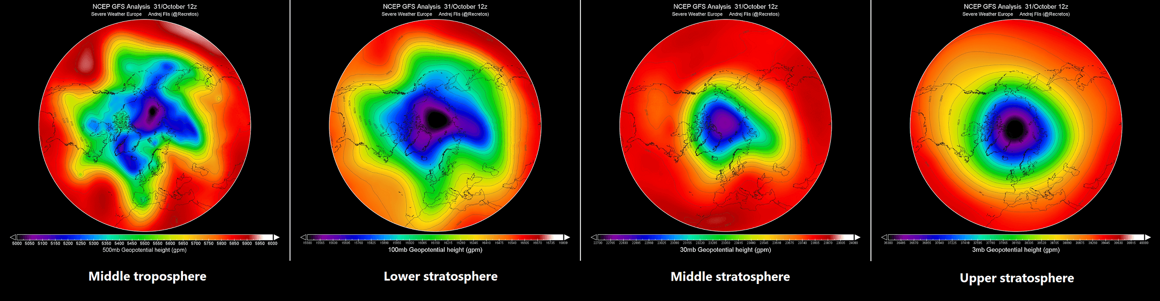
The process is exactly the same over the Southern Hemisphere. But there is much less terrain in the Southern Hemispere, so there are less disruptions of the stratospheric Polar Vortex.
For an even better idea, we produced a high-resolution video for you, which very nicely shows the Polar Vortex spinning over the Northern Hemisphere at around 5km altitude.
This high-resolution video shows the Polar Vortex spinning over the Northern Hemisphere at around 5km altitude. In the video, you can see the temperature forecast for this altitude, as the temperature is a very good tool to see the actual size and shape of the complex structure of the Polar Vortex.
You can see in the video what the true extent of the Polar Vortex looks like at lower altitudes. Be aware of its “arms” extending into eastern and western United States, also bringing along colder weather into the region in early February.
WINTER 2020/2021 STRATOSPHERIC WARMING
To get an idea just how important these dynamics are, we can look back no further than this past Winter, where we experienced a stratospheric warming event in early January.
Usually, we look at the polar vortex in the stratosphere at the 10mb level. That is around 28-32km (17-20 miles) altitude. This altitude is considered to be in the middle stratosphere and serves as a good representation of the general dynamics of the polar vortex.
The strength of the polar vortex is usually measured by the power of the winds inside it. This is done is by measuring the zonal (west to east moving) wind speeds around the polar circle (60°N latitude).
Below we have an analysis from the NASA monitoring system, where you can see a very interesting progression of the 2020/2021 Winter season in the stratosphere. The image shows the stratospheric jet stream, which reversed into negative values in early January.

This was a breakdown/collapse event of the stratospheric Polar Vortex, initiated by a very strong Sudden Stratospheric Warming event.
In late December, a warming sequence began in the stratosphere, expanding from Europe over into central Asia. It was starting to engulf the outside layers of the polar vortex. The cold core of the polar vortex was still rather intact at this point, holding temperatures colder than -80°C in the center over Greenland.

Just two days later, the warming wave reached its peak over Siberia, with maximum temperatures in the wave reaching up to +5°C or higher. In normal conditions, the temperatures here are over 30-40°C lower, so this was a significant warming wave at this stage.

On January 5th, the date of the Sudden Stratospheric Warming event was marked, as the winds around the polar circle have reversed. The stratospheric warming wave has crawled over the entire North Pole in the stratosphere, effectively splitting the cold-core of the polar vortex into two parts.

One part of the broken polar vortex has moved over North America and one over the European sector. At this point, this does not have much to do directly with the winter weather on the surface, as this is at a 30km altitude. But the Polar Vortex was collapsing like a house of cards at this point, with effecty eventually reaching the ground.
The next image below shows an atmospheric pressure index. Negative values indicate lower pressure (blue colors) and positive values indicate higher pressure (red colors). We have altitude from the ground up to the top of the stratosphere (~46km), covering Winter 2020/2021 and early Spring 2021.
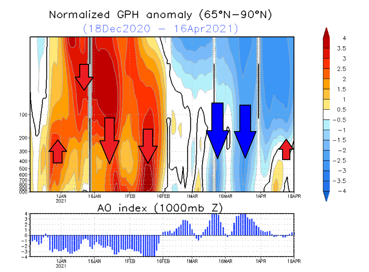
You can see strong positive values in the stratosphere in early January, associated with the buildup of high pressure during the stratospheric warming event. The event and its influence were slowly descending over time, reaching the lower levels by mid and late January.
This persisted well into February, influencing the weather circulation even when the stratospheric warming was already over in the higher levels.
Knowing what the polar vortex is and what stratospheric warming is, we can look at what is currently going on high above the South Pole.
SOUTH POLAR WINTER WARMING EVENT 2021
The Southern Hemisphere has opposite weather seasons to the Northern Hemisphere. So while we are going towards late Summer, there is still Winter in the Southern Hemisphere.
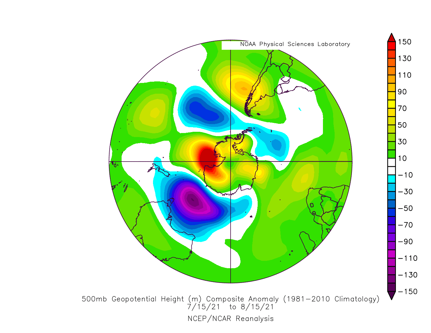
In the image below we can see the lower 30km (18.86 miles) of the atmosphere. We can see lower pressure than normal in the stratosphere, connecting down in June. but higher pressure anomalies pushed the lower pressure back upwards in early and late July. That has also sent a lot of energy vertically upwards into the Stratosphere.

Looking below at the pressure patterns since mid-July, we can see the high-pressure buildup over the South Polar regions. At the same time, a strong low-pressure system was pushed out, towards Australia.
Below we have a special image from NASA. It shows the wind speeds of the jet stream in the Polar Vortex over Antarctica at around the before mentioned 30km altitude (10mb level). The violet line shows it was actually weaker than normal through most of the southern Winter.
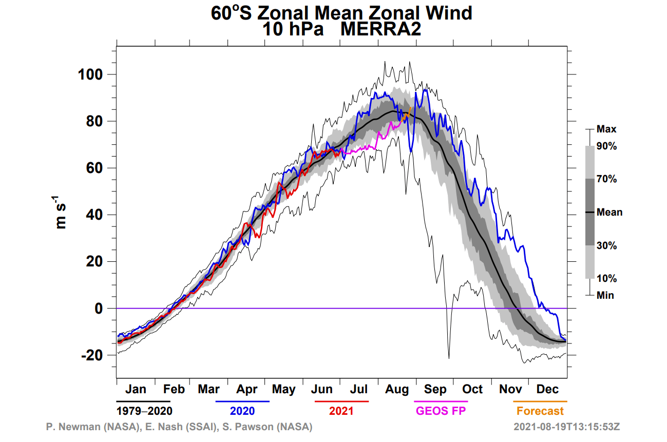
Temperatures in the core of the stratospheric Polar Vortex were around normal. But they are already rising, as the Winter season is coming to an end over the Southern Hemisphere, so the upper atmosphere is already warming up as more sunlight reaches in.
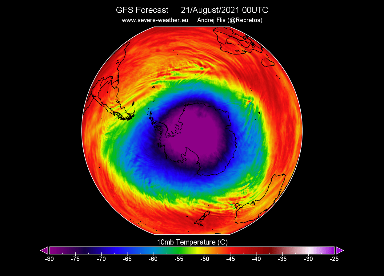
In the past days, the Polar Vortex over the south pole, was fairly healthy. It had a nice round shape and a deep low-pressure core. The pressure rises as we go towards the Equator, as the air there is getting warmer. The charts below are for the 10mb level, which is around 30km (18.6miles) altitude.

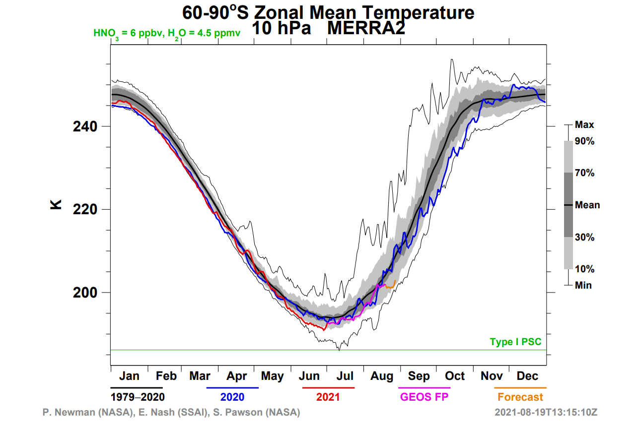
The temperatures also show a nice healthy cold core at this level (10mb ~ 30km). Temperatures in the core of a polar vortex can reach below -90°C (-130°F) at these levels.
We can look at the temperature anomalies, to see that the core of the Polar Vortex was colder than normal. It was quite well placed over the south pole.
But things are now changing. Looking at the coming days, we can see a high-pressure area building towards the southern Indian Ocean. It will be strong enough to press against the Polar Vortex, pushing it slightly off-center.

Along with the high pressure, comes a warming wave from the South Atlantic. If you look back at the previous temperature chart, you can see that the cold-core has lost quite a lot of its cold power and is being pushed off-center with the polar vortex.

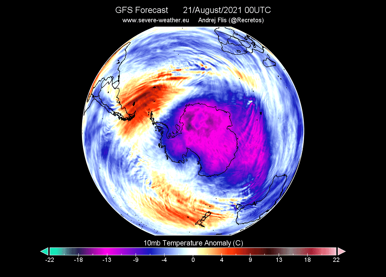
Looking at the anomalies, we can see a strong warm anomaly developing, with temperatures over 20°C (36°F) above the long-term average. Colder than normal air is pushed out, creating negative anomalies over the South Pacific ocean.

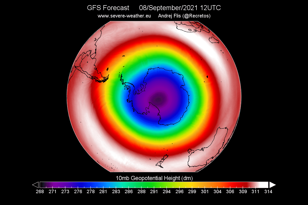
In the first week of September, the Polar Vortex will further weaken, with pressure rising around it. This will temporarily weaken the stratospheric jet stream, but the Polar Vortex will keep a fairly stable shape.
Looking at temperatures, we can see the warming wave engulfing the entire core from the other side. This is a new temperature wave, starting from over the South Pacific Ocean.
This is a very potent temperature wave, covering a large area with temperatures 15°C (27°F) warmer than normal for this time of year. This warming wave is larger than the surface area of Antarctica. Th warming wave will attempt to expand inside, over the south pole.
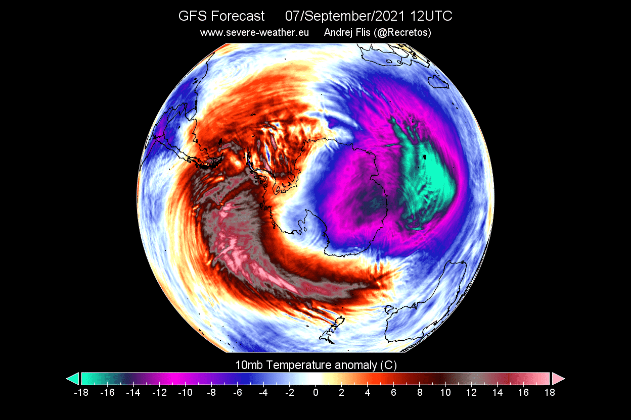
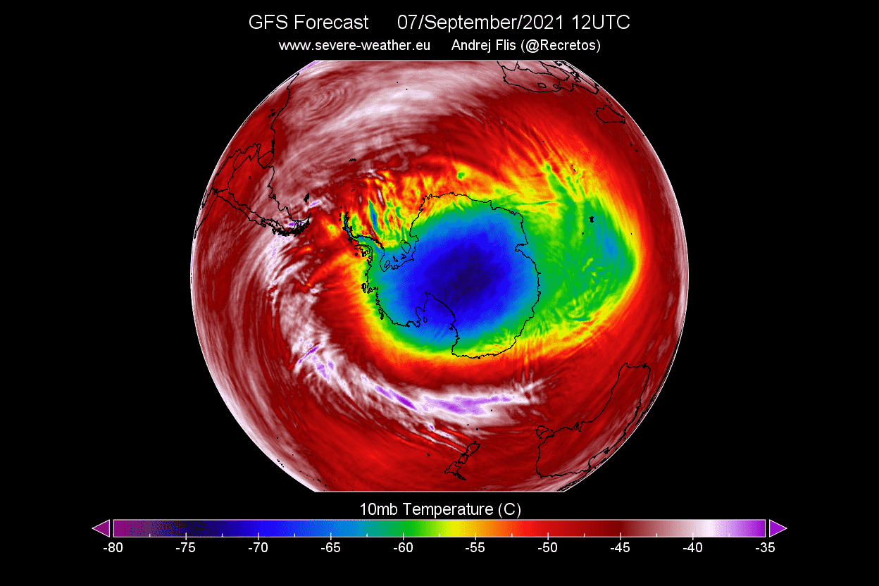
Looking further up at the 1mb level, at 45km (28 miles) altitude, we can see the warming has completely engulfed the polar regions. The cold-core is completely removed and broken down into two separate areas. This shows that this event is perhaps stronger in the higher altitudes currently.
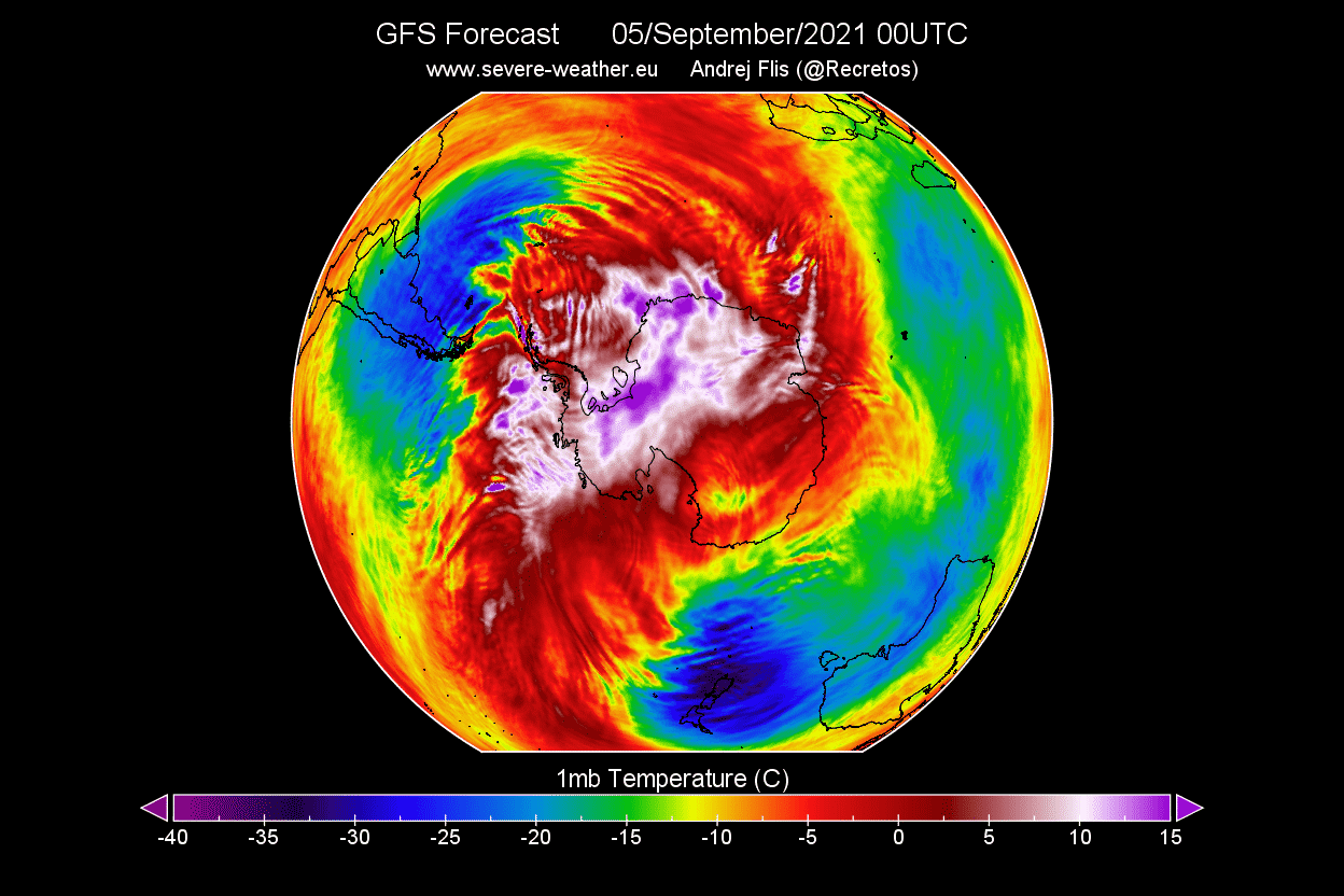
The graphs below show the temperature wave forecast in the stratosphere, where we can see the two warming waves, with the wave-1 pattern being much stronger, but with the wave-2 pattern lasting longer. The wave number basically tells us how many warming waves are present at the same time.

But as you will now see, there was a similar but more powerful event just 2 years ago over the South Pole. It was strong enough to affect even the ionosphere and thermosphere over the Northern Hemisphere, and it reduced the size of the infamous Ozone Hole.
POWERFUL STRATOSPHERIC WARMING – SOUTH WINTER 2019
A much stronger Stratospheric warming has occurred in September 2019 over the South Pole. The peak warming wave reached positive temperatures, up to 20°C (68°F). The Polar Vortex completely broke down, changing the weather patterns and circulation.
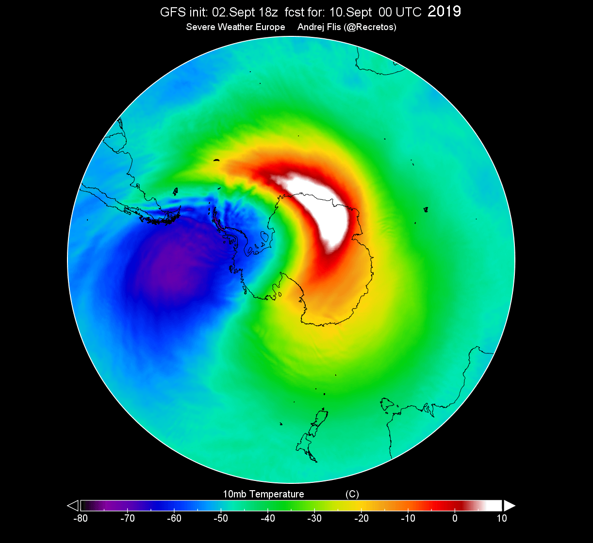
These temperatures might not seem anything special at first. But at that altitude, temperatures were over 40°C (78°F) above the normal value. The image below shows the temperature anomalies during this Stratospheric Warming event in 2019 over the South Pole.

You can nicely see on the image below, how the average polar cap temperature increased rapidly. It raised well above the long-term average line, showing the typical stratospheric warming temperature spike.

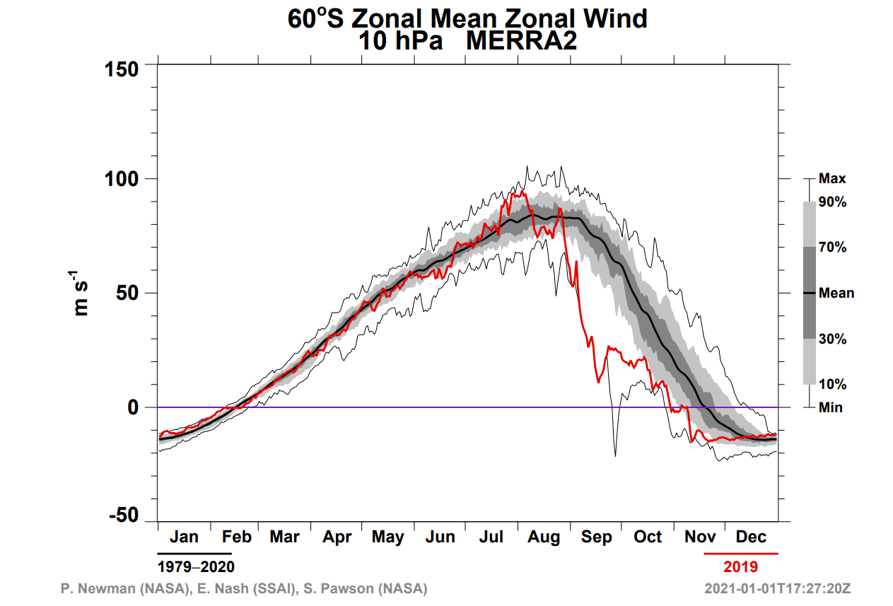
Zonal winds also decreased, indicating a collapse of the Polar Vortex. The winds never fully reversed during the main event, going negative, but the event was strong enough to produce important weather effects in the coming weeks.
Now, why was this important? If you look at the image below, you can see a simple schematic, of the global air circulation, between the hemispheres. There is much more flow and dynamics in the Winter hemisphere, while the Summer hemisphere is calmer generally.

This is called the “Brewer-Dobson circulation“, and connects the circulation from both Hemispheres higher up in the atmosphere. In reality, it is far more complex, but this simple schematic shows the main idea of airflow and energy transfers.
Below we have interesting graphics from a study made this year, about the stratospheric warming event in 2019 over the South Pole. The graphics show Total Electron Content (TEC) change in the Ionosphere over the United States and Europe.
The first image shows the Ionospheric anomaly over the United States, following the strong stratospheric warming event over the South Pole. Strong 40-80% anomalies in electron charge were observed in the ionosphere over the United States.
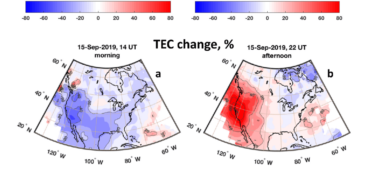
The same, but reversed change was observed over Europe, as the energy wave from the strong Stratospheric warming event already reached the Northern Hemisphere.
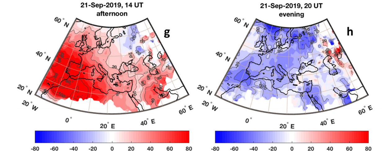
Overall, the study found both positive and negative disturbances in the thermospheric O/N2 ratio and total electron content over the United States and over Europe. This plays a role in the geomagnetic of the Earth’s atmosphere, and the changes were strong enough to be detected and measured.
Not just in the higher atmosphere, but also in the lower atmosphere, direct weather changes were observed following this strong event. signs have also emerged that the event was strong enough to even have a weather effect on the following Winter 2019/2020 in the Northern Hemisphere.
THE OZONE HOLE
The strong stratospheric warming event in 2019 over the South Pole had one more important effect. it helped to keep the Ozone Hole at its lowest size in the past decades.
Ozone is the protective layer in the atmosphere, that shields us from dangerous ultraviolet solar radiation. In the late 20th century, emissions of chemical substances called halocarbons affected the number of ozone molecules in the atmosphere. It resulted in the creation of dramatic annual ozone reduction over the Antarctic region, known as the Ozone Hole.
These chemicals, together with sunlight and very cold temperatures, start a photochemical process, that destroys the Ozone. If one ingredient is missing, the ozone molecules and the ozone layer cannot be destroyed.
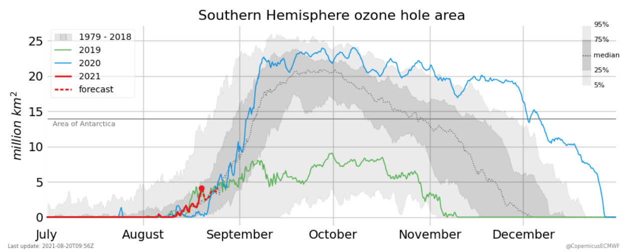
Below we have a very cool graph, that shows the area of the ozone hole over Antarctica. Red line shows this year, and we are still t a small size, but at the beginning of the season. The green line shows 2019, and it is a very low level, actually one of the lowest in past decades. Blue line is last year, with a near-record large ozone hole.
The Ozone destruction process was limited in 2019, thanks to the strong stratospheric warming event that we discussed above over the south pole. It limited the cold air available, thus greatly limiting the ozone destruction process.
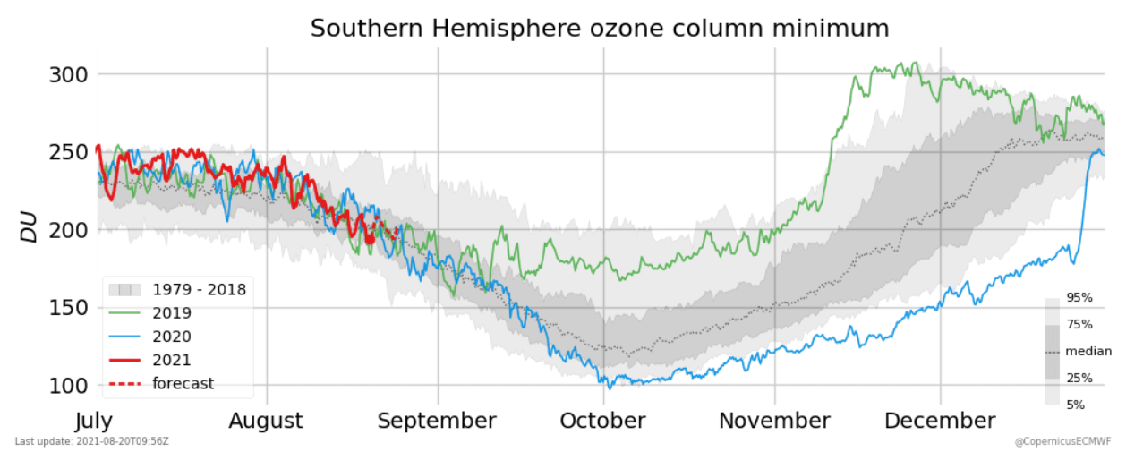
We can see the ozone mass deficit in the image below. It is the amount of ozone destroyed by the chemical process. In 2019 (green line) there was very little ozone destruction, as the stratospheric warming event limited the ozone destruction process.

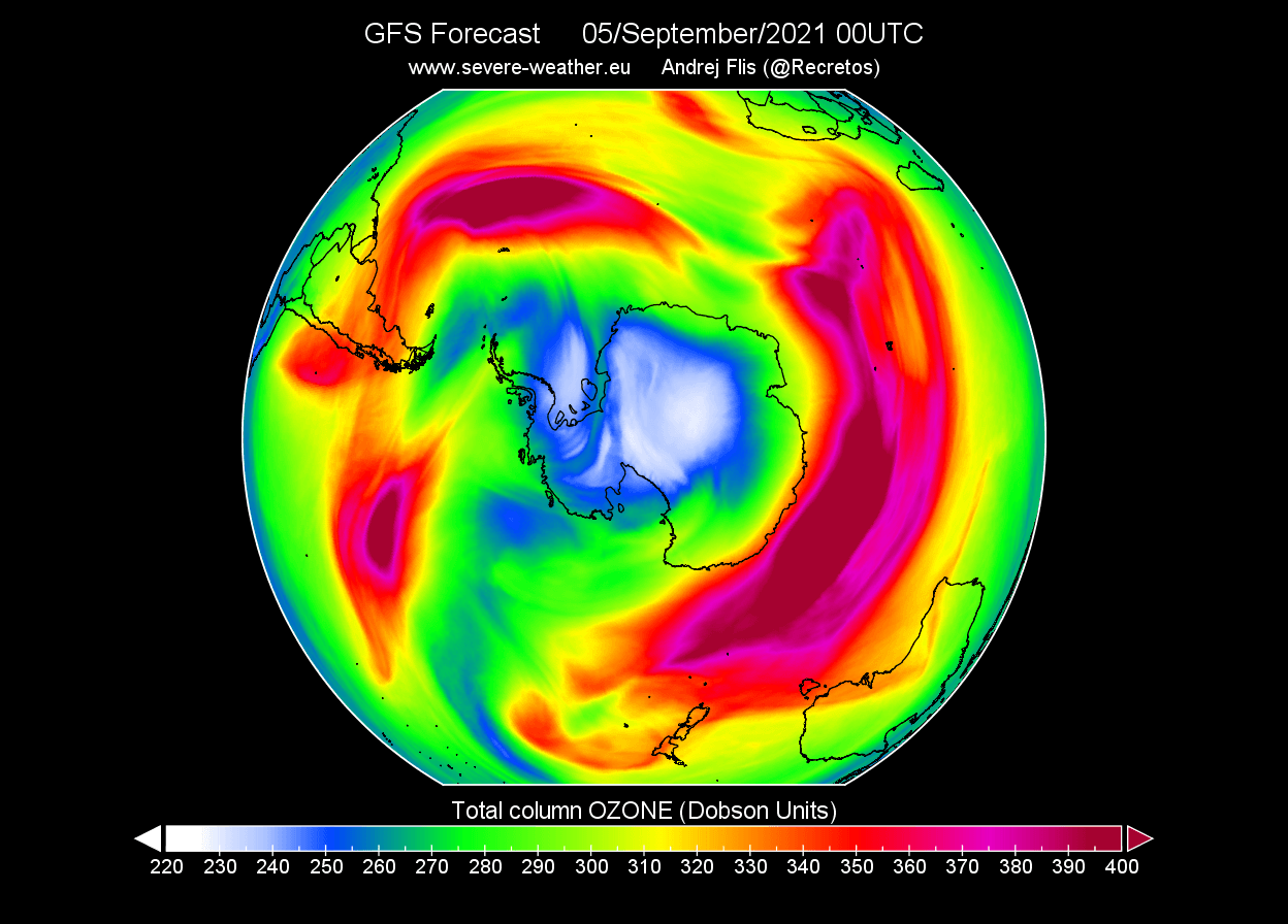
Looking at the latest conditions, we can see a small ozone hole already developed. The image below shows total atmospheric ozone, with a significant lack of ozone in the middle. That is the infamous ozone hole.
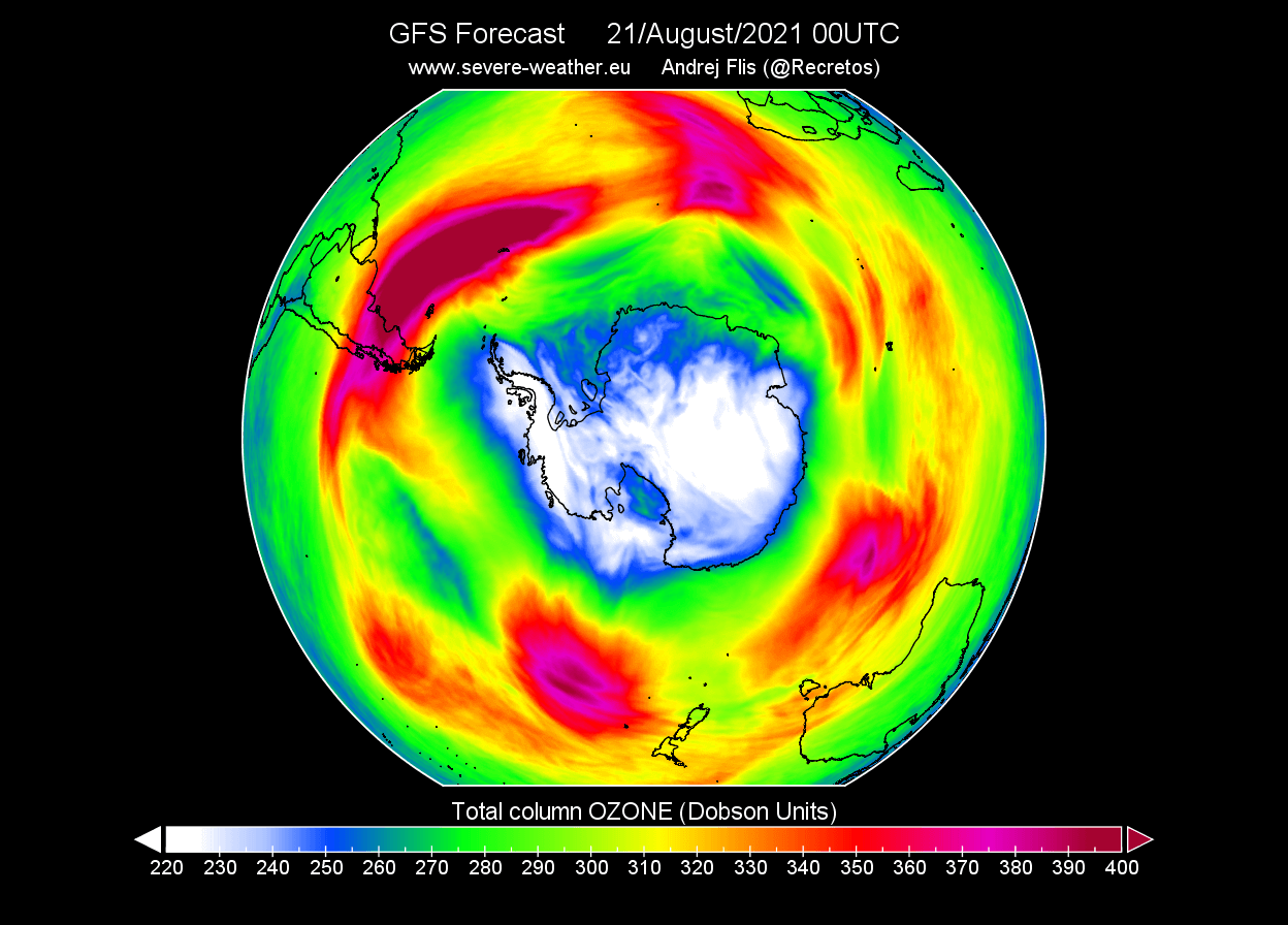
But looking ahead at the forecast, we can actually see the ozone hole reducing in size, while it should be growing at this time of year. This is a likely side effect of the upcoming warming event in the stratosphere over the south pole.
We will keep you updated on latest global anomalies and weather pattern development, so make sure to bookmark our page. Also, if you have seen this article in the Google App (Discover) feed, click the like button (♥) there to see more of our forecasts and our latest articles on weather and nature in general.
Don’t miss: