Massive craters in the frozen ground of Siberia strike the Russian landscape of Yamal and Gydan Peninsula. The origin of such incredible morphologies is due to powerful explosions of methane gas from the frozen ground. Here we try to give a comprehensive explanation of such peculiar and violent events occurring in the Russian Permafrost.
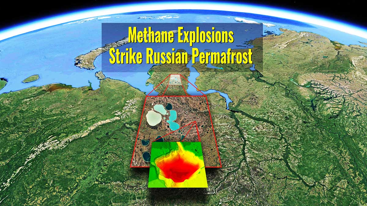
THE CRATERS OF YAMAL AND GYDAN PENINSULA IN SIBERIA
For several years now mysterious giant craters form in the Siberian tundra. Like big and large golf holes, seventeen have been found so far with the help of three-D mapping by using drones. Scientists have begun to work out how they are formed.
They generally start with the build-up of methane gas in the permafrost. As the pressure in these gas accumulations increases, a mount forms. Once the pressure passes a critical point defined by the density of the upper layer of ground, an explosion throws debris hundreds of meters. That’s how these craters, which can be thirty to forty meters deep, and over forty meters wide, are formed.

Photo credits Sylvia Buchholz/Alamy from BBC report
Methane is a powerful greenhouse gas. In the atmosphere it traps Earth’s heat warming the climate. As the warmer climate deepens the active layer in the Siberian permafrost rising the permafrost temperature and thawing its upper layer, more methane escapes sometimes in the form of these exploding craters. And that sends more methane into the air heating the planet even more.
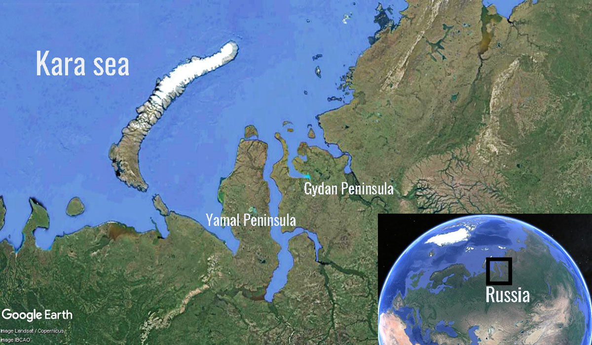
These exploding craters have been mainly limited to two Siberian peninsulae. That’s because these areas have unique conditions: very thick permafrost which is highly saturated with methane that also contains pools of liquid water.
Russian scientists say these craters and other changes are indicative of the rapidly warming and thawing of the Arctic. That can have severe consequences for Arctic residents and the globe. But before going into more detail on how these giant holes are formed, let’s try to understand what permafrost is.
LET’S DEFINE WHAT PERMAFROST MEANS
Permafrost, by definition, refers to the ground that remains below 0°C for at least two consecutive years. More briefly, we can define it as perennially cryotic ground. The term cryotic, better than frozen which implies the presence of ice, suggests a ground temperature below 0°C. In fact, ice is not necessary to characterize the Permafrost, which instead is exclusively defined by the thermal state of the ground. For this reason alone, it is important to bear in mind that permafrost thaws, while ice melts.
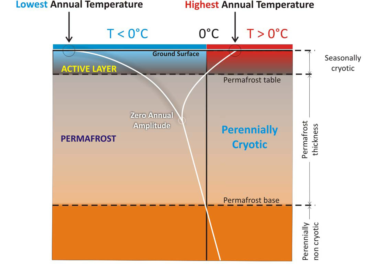
Except under very special circumstances, permafrost does not extend to the ground surface due to solar radiation and above-freezing temperature thawing the uppermost layer of ground during summer. Exceptions exist under perennial snow beds or cold-based glaciers. The uppermost layer, which freezes and thaws on a seasonal basis, is called the Active Layer, and you can follow this description in the scatch above.
To understand how the temperature in the ground behaves in areas interested in permafrost, we drew the sketch below. The “Y” diagram explains how the ground temperature behaves from surface to depth. Annual extremes are of course the greatest close to the surface, becoming gradually smaller and moving down.

At a certain depth, the temperature is constant all year round; this is the “Zero Annual Temperature” depth. From this depth, the temperature starts rising constantly following the geothermal gradient at the rate of 25-30°C per kilometer (72-87 °F per mile).
When the “Y” meets for the first time the 0°C isotherms in the ground, this is the Permafrost table, just below the Active Layer. Below this depth, we find the Perennially Cryotic layer or the Permafrost layer. When the “Y” meets for the second time the 0°C isotherms in the ground, we reached the Permafrost base. From this depth, the ground is perennially NON-cryotic and always thawed.
Usually, it refers to the uppermost layer of the ground in cold environments where permafrost is not present. The images above (seasonally frozen ground in a permafrost-free environment) and below (above the permafrost) are of course oversimplifications but simply highlight what happens in the ground during the seasonal cycles.
There is a well-defined difference in the behavior of the ground in permafrost or non-permafrost terrains. The term seasonally frozen ground, or more strictly seasonally cryotic ground, is used to describe ground undergoing a seasonal cycle of freezing and thawing.

HOW GLOBAL WARMING IS CHANGING THE PERMAFROST
Permafrost is a key component of the cryosphere and occupies around a quarter of the Earth’s land area in the Northern Hemisphere. The change in surface energy balance triggering permafrost degradation may be caused by regional changes in climate such as longer or warmer summer or increased winter snowfalls which insulate the ground from the atmosphere. Another cause could be deforestation both human-induced or natural, such as a forest fire.
If the ground warms for one of these reasons, how does the permafrost react? To understand what happens when such a circumstance occurs, we created the GIF animation below. If the ground warms up, the surface temperature extremes will rise. The same will happen proceeding in depth. As a consequence, the “Y”-diagram will move on the right while permafrost is warming. As you can easily see in the animated GIF, the Active layer will deepen and the permafrost becomes thinner.
There is indeed a lot of concern related to Permafrost degradation, mainly because massive positive feedback related to CO2 and Methane release in the atmosphere might eventually speed up Global Warming.
As the global surface temperature has continued to rise over the recent decades, the risk of permafrost degradation has also increased. The degradation of the permafrost may affect the climate system via many factors such as local ecological balance, hydrological processes, energy exchange, and the carbon cycle, as well as the engineering infrastructure in cold regions and even extreme weather events.
In the video below, we reproduced the possible Permafrost scenarios under different global warming paths, thanks to the huge graphics available here
THE DISCOVERY OF SEVERAL CRATERS IN SIBERIA
The discovery of a couple of tens of meters wide crater in the Yamal Peninsula aroused numerous hypotheses of its origin, including a meteorite impact or migration of deep gas as a result of global warming.
However, the origin of such craters found in the Yamal and Gydan peninsulas can be possibly explained differently, taking into account different cryospheric processes. Such craters, and particularly the most studied named Yamal crater, appear as a consequence of the collapse of a large pingo, which formed within a thaw lake when it shoaled and dried out allowing a large talik below it to freeze back.
Ok, we just introduced several new terms that call for an explanation. First of all, a pingo is an ice-cored hill, usually conic or dome-shaped, that form through the freezing o pressurized groundwater within near-surface permafrost, resulting in the upcoming of overlying frozen sediments.

Most pingos are less than 20 m high, with a basal diameter up to about 250 m, but few are much higher or broader. The highest documented pingo is located in Alaska and it rises about 54 m above the surrounding planes.
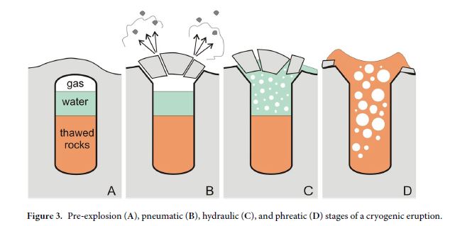
A talik is a layer or body of year-round unfrozen ground that lies in permafrost areas. When the pingo collapse under cryogenic hydrostatic pressure it builds up in the closed system of the freezing talik. This happened before the freezing was completed when a core of wet ground remained unfrozen and stored a huge amount of carbon dioxide dissolved in pore water.
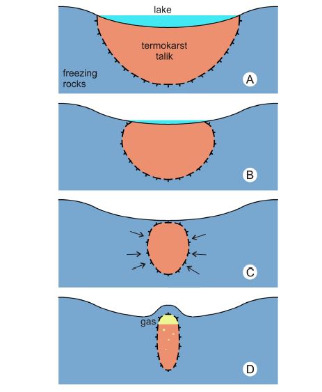
This eventually reached gas-phase saturation, and the resulting overpressure came to exceed the lithospheric confining stress and the strength of the overlying ice. At this point, the pingo explodes, and the demarcation of the crater follows the cylindrical shape of the remnant talik core.
An expedition in 2015 found proof of how such craters at the end almost fill with water, confirming a preliminar hypothesis that in a short period of time (2–3 years) the craters turn into lakes like thousands of others on the Yamal Peninsula.
In Siberian permafrost, large deposits of methane gas are trapped in ice, forming what is called a gas hydrate. Methane remains stable and frozen at certain temperatures, but as the permafrost warms, and its internal strength decreases, it may be less able to withhold the build-up of sub-surface gases, leading to a release.
CLIMATE IN YAMAL AND GYDAN AREA
Significant amounts of permafrost deposits exist in the Yamal and Gydan peninsulas. Here life is still determined by the ice permafrost underfoot. Temperatures easily drop to -50°C (-58°F) during winter.
The area of Yamal and Gydan peninsula presents a continental subarctic climate, according to the climate classification of Köppen (2011). Temperatures in the region vary considerably during the year: the mean air temperature ranges from + 15 °C in July to − 25 °C in January. Mean annual precipitation is about 400-500 mm, with the lowest rate during the winter about 20 mm in February, and the highest rate during the summer months about 60-70 mm in July and August.
These are the typical conditions of the Low-arctic and subarctic continental interiors. Such areas experience a much wide range of temperatures than High Arctic areas. The mean values disguise excessively low temperatures in winter and remarkably high temperatures in summer. Mean annual air temperature, in the end, is the same or slightly higher than in areas north of the treeline.
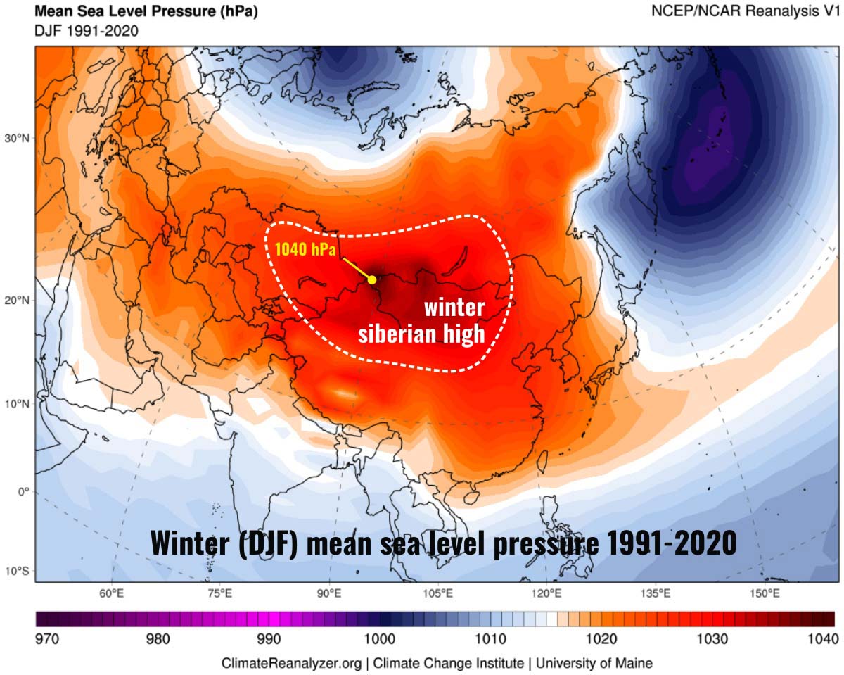
This temperature pattern reflects the absence of moderating oceanic influences. A zone of high pressure over eastern Eurasia builds during the autumn in response to radiative cooling and persists until spring. This reflects in the lowest winter temperatures anywhere in the northern hemisphere.
As an example, Verkhoyansk at 67 degrees latitude has a mean temperature of -48 degrees Celsius in January and almost no precipitation, but for five months in the warm season, temperatures are above 0 degrees Celsius, peaking at 17 degrees Celsius in July.
Canadian locations like Churchill have similar, if less extreme, characteristics with cold winters and moderately warm summers. On average, 4-5 months reports a temperature higher than 0 degrees Celsius.
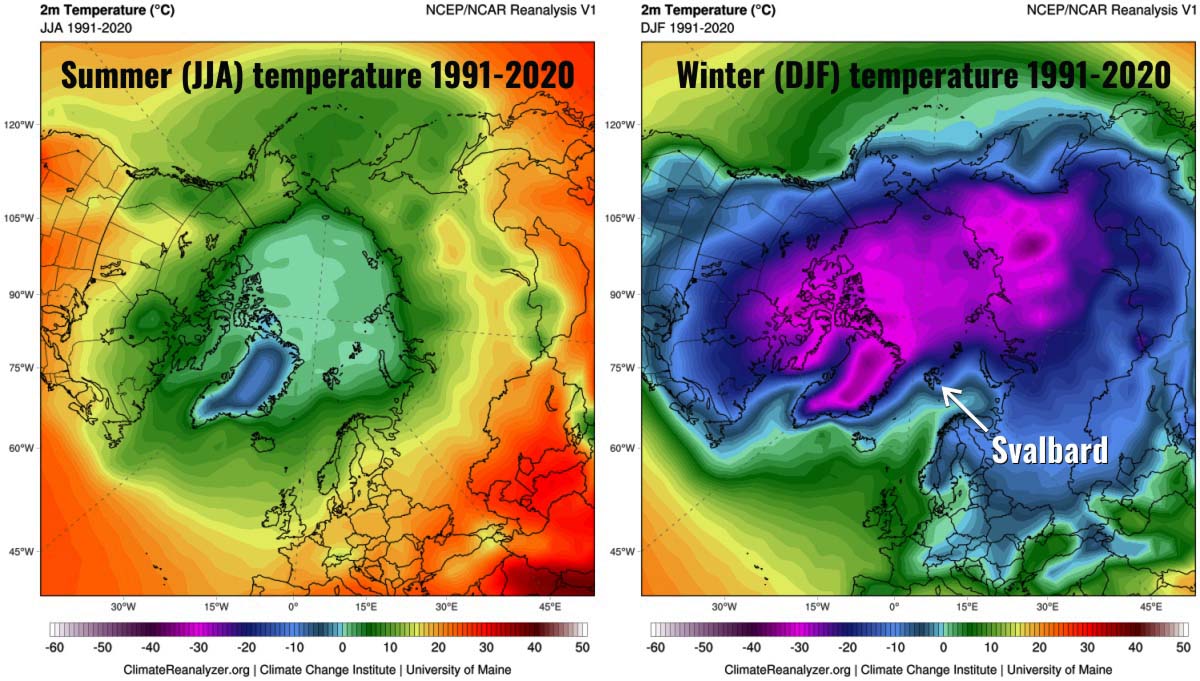
Where permafrost is present, warm summers allow seasonal thaw up to 2-3 meters in depth, while where permafrost is absent, seasonal ground freezing can reach similar depths. On the map below-average summer (JJA) and Winter (DJF) for Eurasia.

Precipitation in subarctic continental interiors is low and ranges from about 180 to 600 millimeters per year. Nevertheless, precipitation is greater than in High Arctic regions because disturbances associated with the Arctic and polar fronts are more frequent at these latitudes.
The majority of precipitation falls in the form of rain and mostly during the summer. Nevertheless, the relatively high summer temperature also promotes high rates of evapotranspiration, so there is a seasonal soil moisture deficit. In the image below, higher summer precipitation between about latitudes 55 and 70 degrees North in contrast with high precipitation in the North Atlantic and North Pacific induced by the Icelandic and Aleutian Lows.
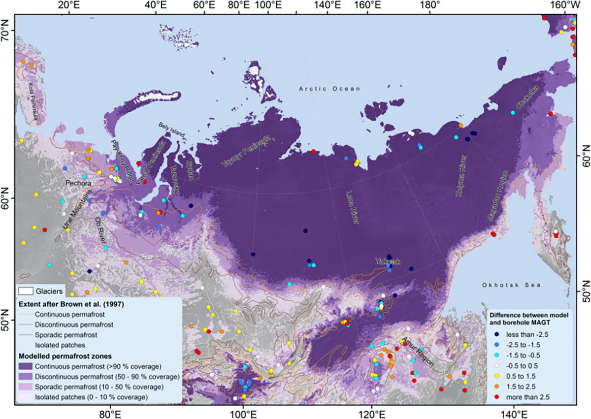
Original image from Obu et al., Earth Science Review available here
MEGASLUMPS AND THE BATAGAY CRATER
But Siberia is used to such weird phenomena in areas dominated by permafrost environments. One of the most intriguing it is certainly the Batagay crater, a dramatic hole in the ground almost 1 kilometer long and 86 meters deep.
The Batagay Crater doesn’t dominate the landscape, IT IS THE LANDSCAPE. The walls of this huge crater are completely made of ice and mud. Outside the Batagay crater, you can hear Cracks of ice in the distance while it melts off.
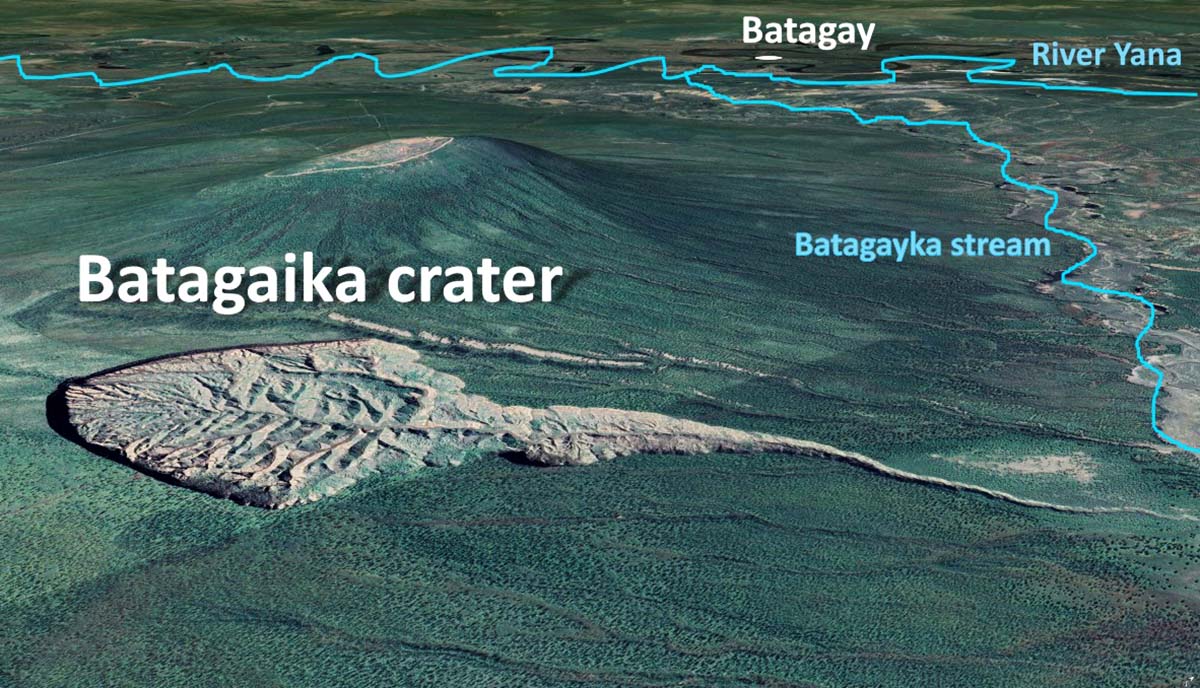
Rendering from Google Earth edited by SWE
The enormous crater started off as just a small gully in the 1960s. Locals in the area avoid it, saying it is a “doorway to the underworld”. But for scientists, the site is of great interest. Remote sensing observations show that the boundary of the slump moves 20-30 m per year.
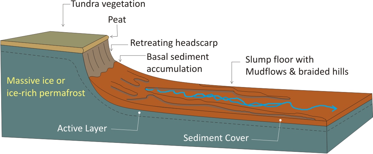
These ice-reach sediments of perennially frozen ground are exposed to ongoing thawing. In other words, ice turns into water that evaporates or melts and flows away and the residual sediments, which are no longer kept together by ice, subside. This results in a chaotic landscape surface due to the variable ice content of the sediments. The Barangay crater is the biggest permafrost crater in the world: but what is permafrost?

Another photo of Batagay Crater by Katie Orlinsky
More technically the Batagay Crater is a Retrogressive Thaw Slump, called also Megaslump. These structures are rapidly evolving slope features resulting from the degradation of ice-rich permafrost. Such processes are universally described under the term Thermokarst. As with many terms in the periglacial wordlist, this term derives from the apparent similarity between some permafrost-degradation landforms and karst landforms developed on limestone and carbonate rocks.
Retrogressive Thaw Slump has two main morphological components: a steep vertical or near-vertical icy head-scarp and a low-gradient slump floor typically sloping 2 – 15°. Retrogressive Thaw Slumps conceivably represent the most active of all Thermokarst landforms. Nevertheless, Thermokarst progress is a thermal rather than a solution phenomenon, independent of underlying lithology, and includes completely diverse processes. That is just the definition of what is happening at Batagay Crater.
Looking at the lowest exposed layer at the base of this slump, scientists suggest the permafrost at the base of the Batagay Crater is particularly old. Preliminary dating reveals how the permafrost here could be 650,000 years old. To learn the age of the outcropping permafrost researchers rely on luminescence dating, which reveals the last time minerals in the soil saw daylight. If it is so, would make it the oldest reported known permafrost in Eurasia.
As such, this giant gash in the ground offers opportunities to study much further back into the past. Each exposed layer of the Batagay Crater wall is like a geological snapshot, helping scientists unravel how permafrost and surface vegetation responded to past warm and cold climates. It gives a window into times when permafrost was stable and times when it was eroding.
We will keep you updated on this and much more, so make sure to bookmark our page. Also, if you have seen this article in the Google App (Discover) feed or on social media, click the like button (♥) to see more of our forecasts and our latest articles on weather and nature in general.