A Polar Vortex is now emerging in the Stratosphere over the North Pole. It began forming as seasonal cooling intensified and will continue to strengthen well into the Winter of 2022/2023. With a long history of Winter weather impacts over the United States and Europe, it is being closely monitored throughout every fall and Winter.
As you will see, there are many layers to the Polar Vortex and different weather outcomes it can produce. But, regardless of strong, weak, or collapsed, it always plays an important weather role.
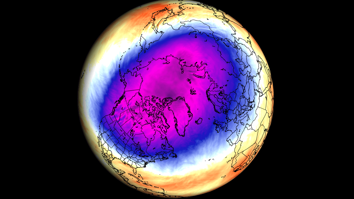
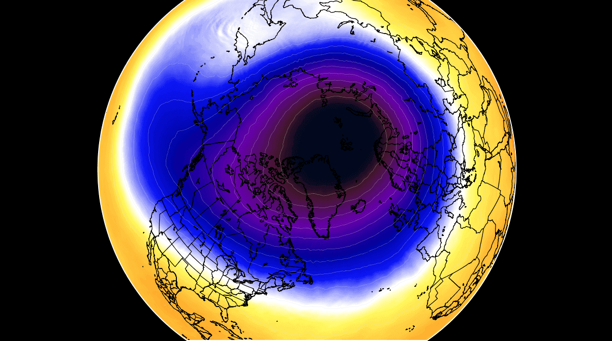
The image below shows one of the strong Polar Vortex events from a few Winters back. Such a near-circular shape usually means strong stratospheric circulation. But first, what is the Polar Vortex, why do we care about it, and why should you?
WHEN THE NORTH POLE STARTS COOLING
As we head into autumn, the polar regions start to receive less sunlight. With less solar energy, temperatures begin to drop and seasonal cooling begins over the north pole.
But as the polar temperatures drop, the atmosphere further to the south is still relatively warm as it continues to receive light and energy from the Sun.
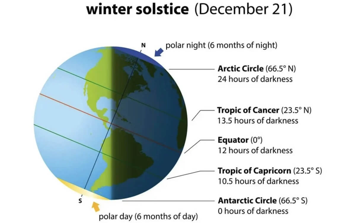
You can see the winter solstice in the image below. The polar regions receive little to zero solar energy compared to regions further south, which still receive plenty of sunlight and warmth.
But, as temperature drops over the polar regions, so does the pressure. This process is the same on the surface and up in the Stratosphere.
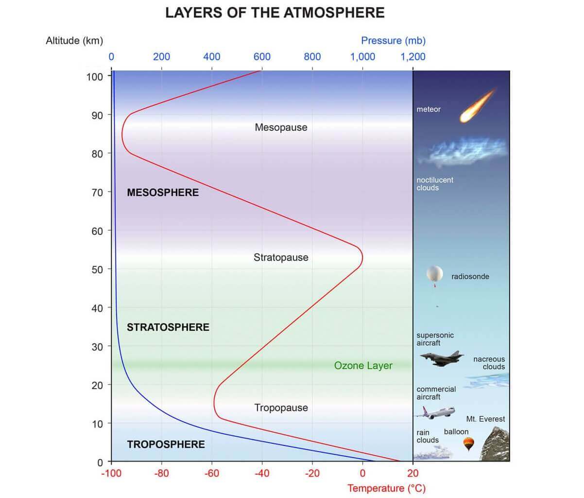
You can see the layers of the atmosphere in the image below. The troposphere (blue layer) and the weather are on the bottom, and the Stratosphere (green layer) with the ozone layer above it.
This causes a strong global pressure difference between the polar and sub-tropical regions, and a large low-pressure (cyclonic) circulation starts to develop across the Northern Hemisphere. It extends from the surface layer far up into the Stratosphere. This is known as the Polar Vortex.
We produced a 3-dimensional display of the Polar Vortex, extending from the lower levels into the Stratosphere. The vertical axis is greatly enhanced for better visual purposes. You can see in the image below what the actual structure of the Polar Vortex looks like.
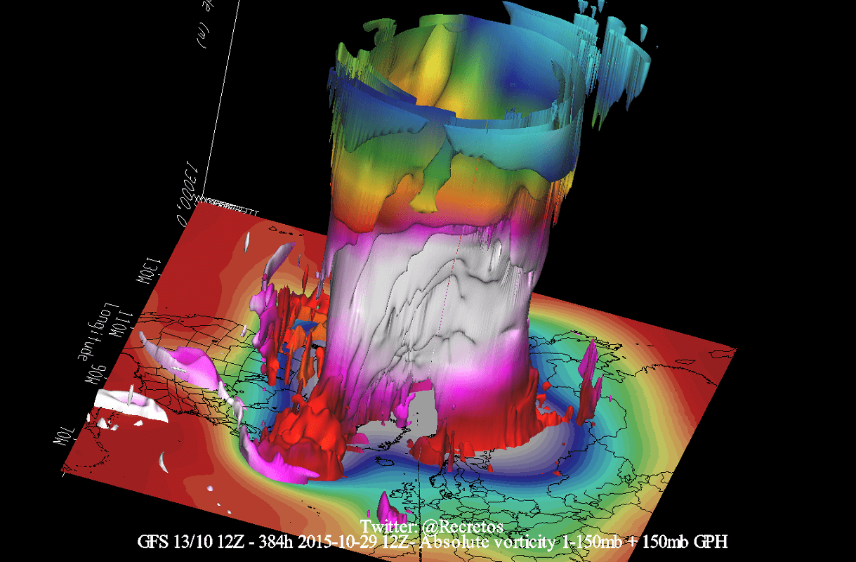
Its upper (stratospheric) part is more circular and symmetrical as it spins higher above the ground. The lower structure of the polar vortex is much more uneven and disrupted. That is due to the influence of the terrain/mountains and strong pressure systems acting as obstacles in the flow.
The image below shows a typical example of the high-altitude Polar Vortex at around 30km/18.5miles in the middle Stratosphere during Winter. It is circular in shape, with the temperature dropping quickly towards its inner core.
The stronger winds are typically found in the outer edge, also called “the surf zone”. As you will soon find out, winds are very important when talking about the polar vortex, as they are usually the first to show that something in the polar vortex is changing.
In the next image below, we have the bottom of the polar vortex at around 5km/3miles. The closer to the ground we go, the more deformed the polar vortex gets because it has to interact with the mountains and overall terrain.
Be aware of its “arms” extending into the lower latitudes, bringing along colder air and snowfall. These arms also pack a lot of energy and can create strong winter storms, like a Noreaster’ in the United States or cold air outbreaks in Europe.
So to recap, the Polar Vortex behaves like a very large cyclone, covering the whole north pole, down to the mid-latitudes. It is connected through all atmospheric levels, from the ground up, but usually has different shapes at different altitudes.
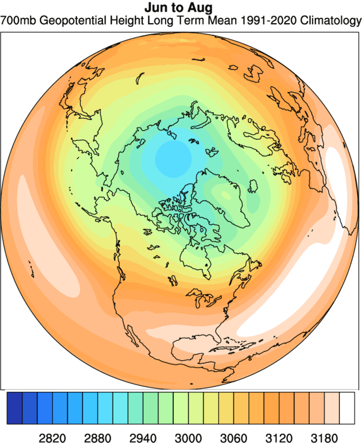
Two special images below show the seasonal difference in polar circulation. The first one shows the 700mb pressure level height (in meters) during Summer. So as you can see, with warmer temperatures over the Northern Hemisphere, lower polar circulation is weak, and pressure is higher across the entire hemisphere.
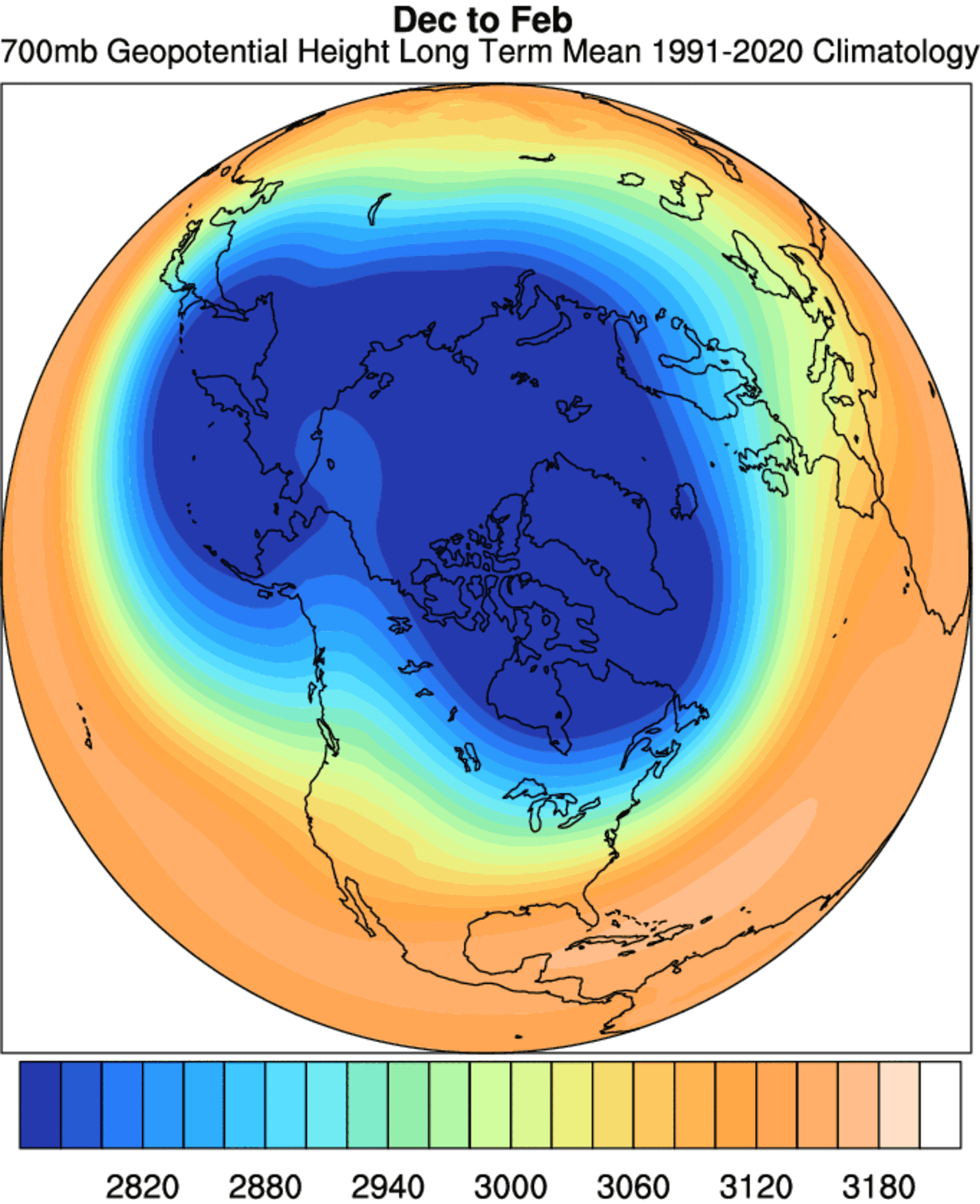
But this next image shows the same pressure level but during the Winter season. The scale is the same in both images, so you can see how much stronger and more widespread the polar circulation is when temperatures drop over the polar regions, lowering the pressure and amplifying the circulation.
The whole process is even more intense in the stratosphere. During the Summer, there is an actual anticyclone spinning over the poles, replaced by deep and strong cyclonic circulation and low pressure as we head into Fall, also known as the Polar Vortex.
We are typically focusing more on the Stratospheric Polar Vortex, as it plays a very important role in weather development throughout the winter season. It is known for its strong influence down from the Stratosphere.
To put the Polar Vortex into perspective, we produced a high-resolution video below, showing the vortex spinning over the Northern Hemisphere in the Stratosphere at the 30mb level, around 23km/14miles altitude.
The video shows the NASA GEOS-5 analysis for late January 2022. Notice how the stratospheric vortex covers a large part of the Northern Hemisphere. This is because it spins over the Northern Hemisphere, driving also the winter weather below with its circulation.
The main takeaway from the video should be that the Polar Vortex is not just one single winter storm or a cold outbreak that moves from the Midwest into the northeastern United States.
It is one large cyclonic area spinning over the entire Northern Hemisphere, from the ground up to the top of the Stratosphere and beyond, reaching over 50km/31miles in altitude.
POLAR VORTEX SEASON 2022/2023 BEGINS
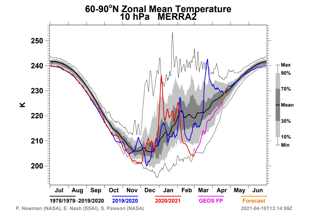
As we mentioned above, the cooling over the north pole has already begun. Below is the NASA analysis graph for temperature in the mid-stratosphere over the north pole. The blue line is last year, and the grey/white areas are historical data.
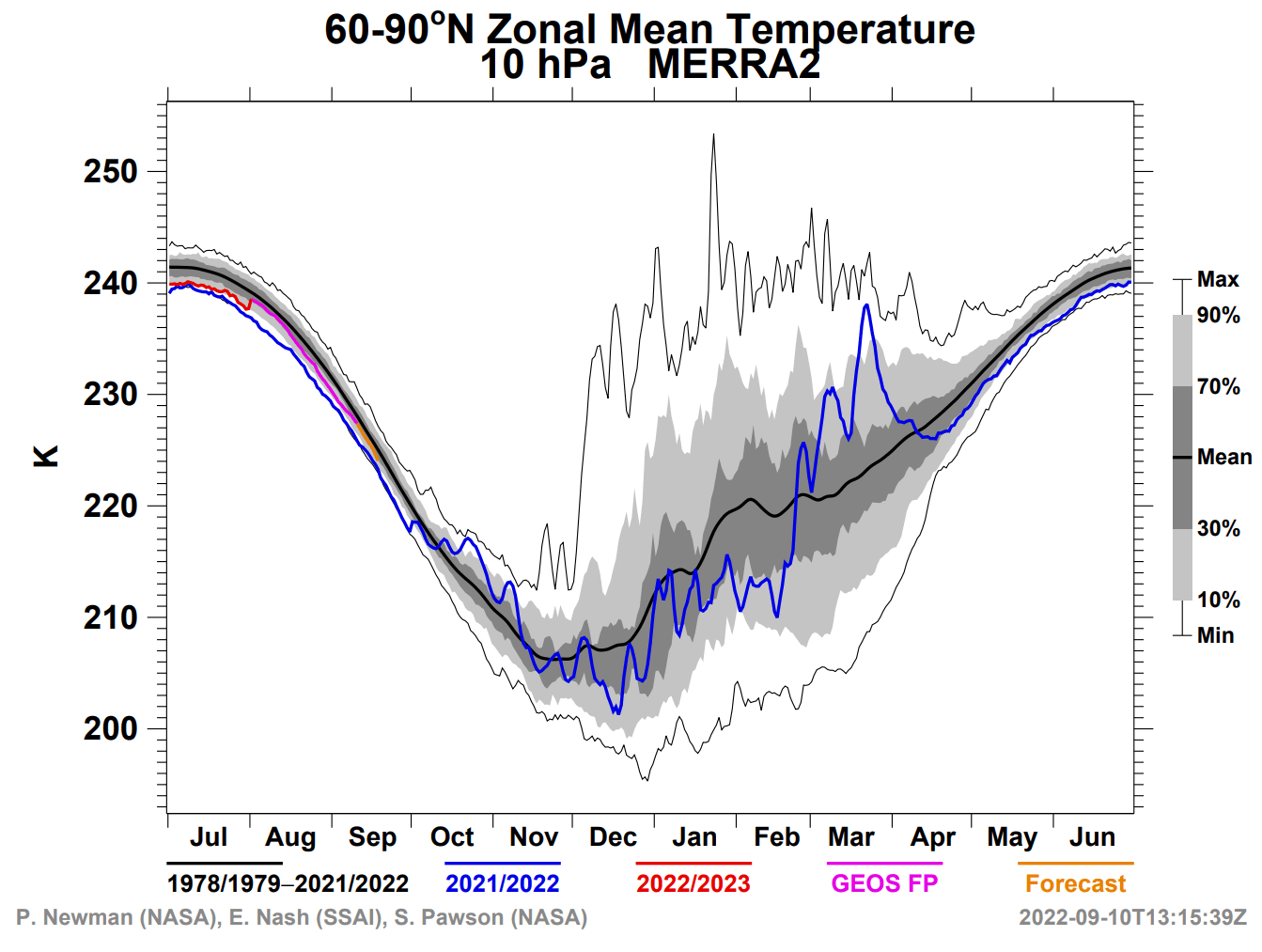
The cooling of the Stratosphere typically starts in August, increasing strongly over September and October. Finally, the Stratosphere reaches its coolest period in November and December, when the polar vortex is usually the strongest.
Currently, the temperature is already dropping in the Stratosphere. In the image below, you can see the temperature change forecast for late September. It shows ongoing cooling over and around the North Pole.
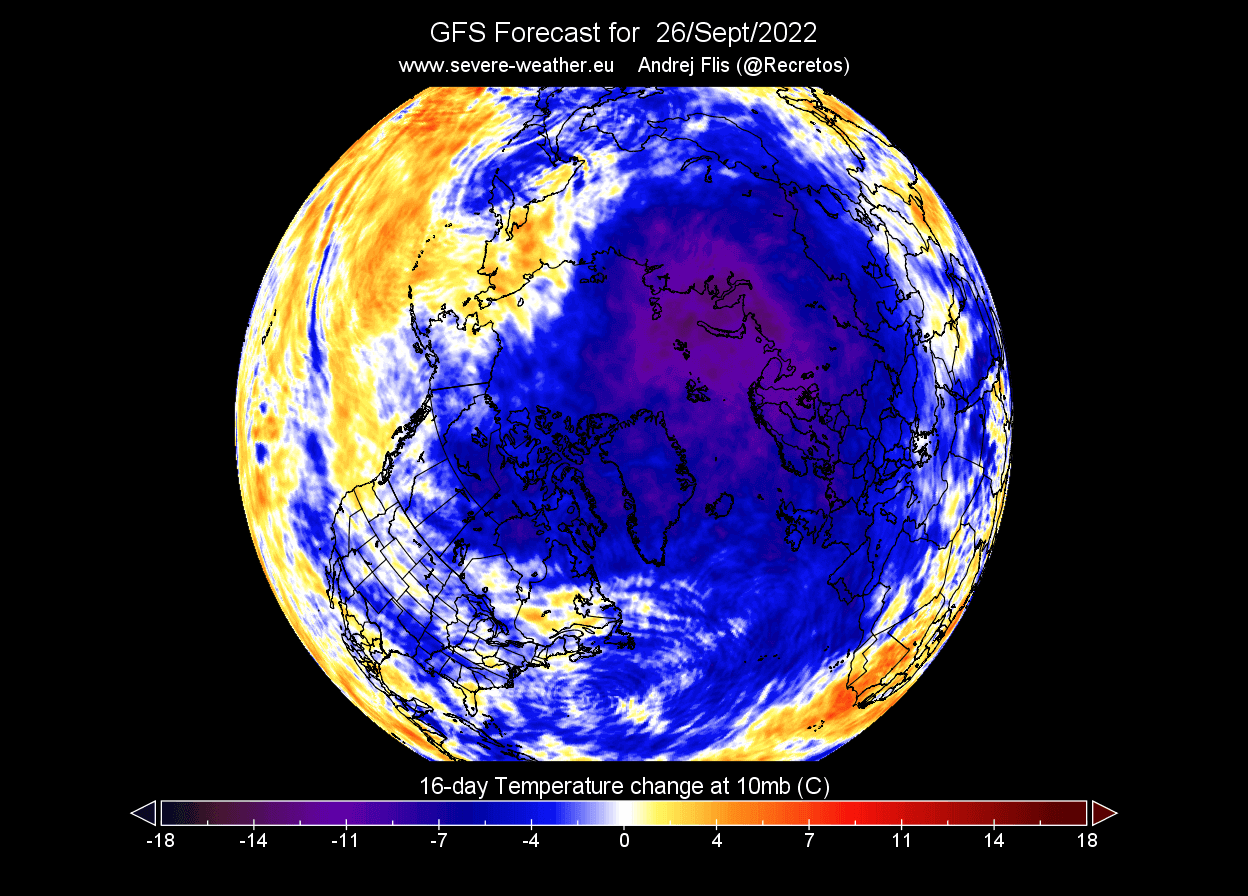
Looking at the actual temperature forecast, we can see a cold core developing over the polar circle. This is the heart of the Polar Vortex, as the colder it gets, the stronger the polar vortex can become. That is because it feeds off the temperature/pressure difference between the polar and the southern regions of the Northern Hemisphere.

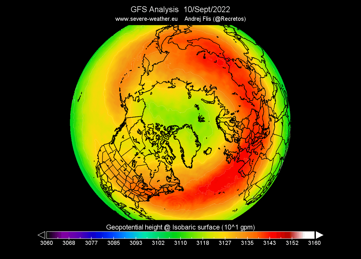
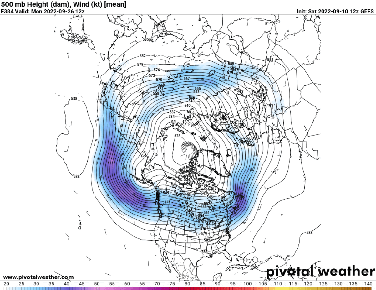
The pressure is also starting to drop rapidly. The image below shows the geopotential height of 10mb level (~30km altitude). As a result, a smaller low-pressure area starts to develop over the Arctic Circle. That is the foundation for the polar vortex of the upcoming Winter 2022/2023.
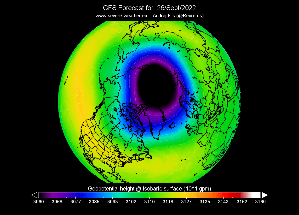
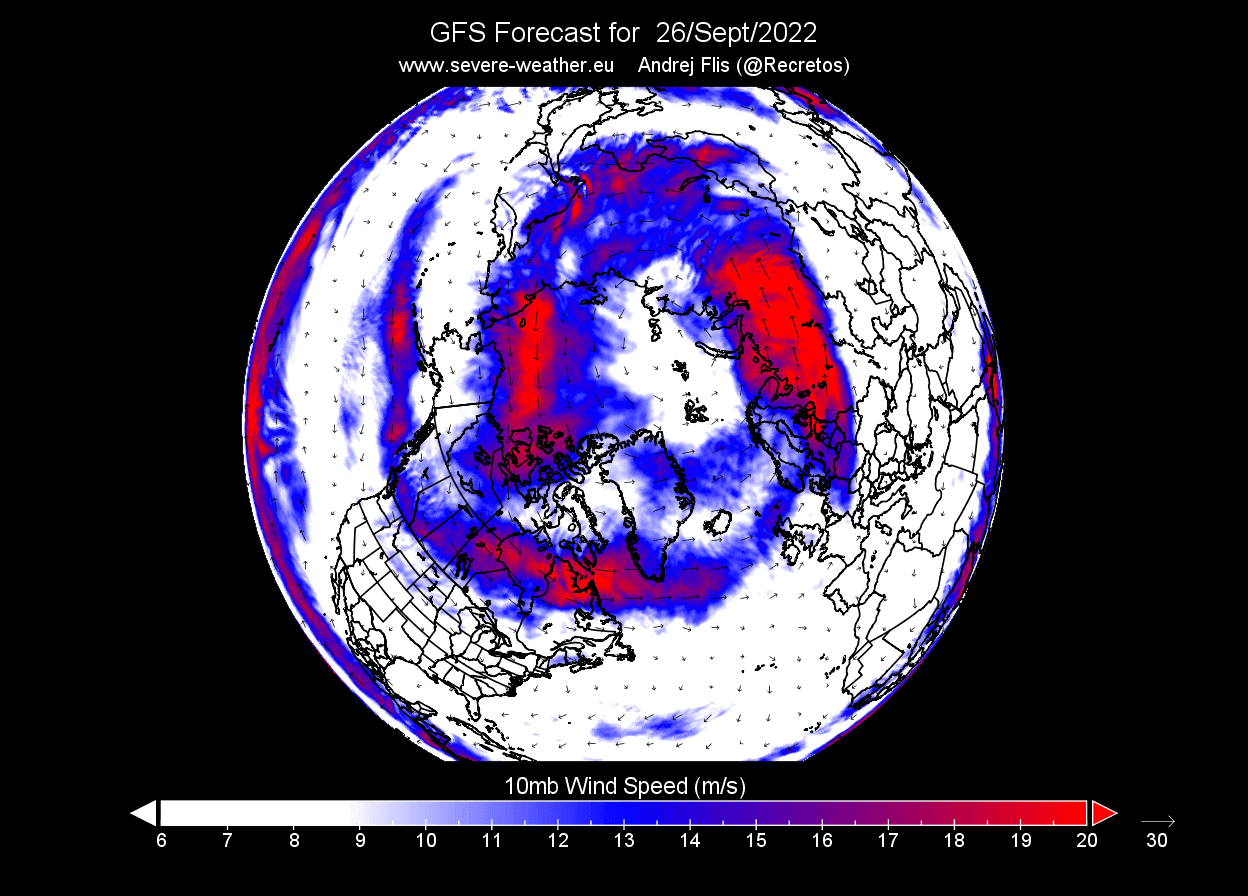
Looking at the forecast for late September, as shown below, you can see the polar vortex is much more developed and rapidly increasing in size and influence. As the pressure drops in the polar vortex, it increases its wind speed and depth. The stronger it gets, the easier it is to influence our weather down at the surface.
Speaking of wind, the current forecast shows the stratospheric jet stream developing. This is also called the Polar Night Jet. The image below shows the stratospheric jet stream in the upper Stratosphere at 1mb level (~45km/28mi altitude)

Looking at the 10mb level (~30km/18.5mi altitude) forecast, we can see the stratospheric jet stream at this level. It has a nice oval shape and is already almost connected across the entire Northern Hemisphere.
The strength of the stratospheric jet stream at the 10mb level is usually used to determine the strength of the polar vortex and its potential influence on the weather. This is especially the case during the early and mid-winter when it is strongest.
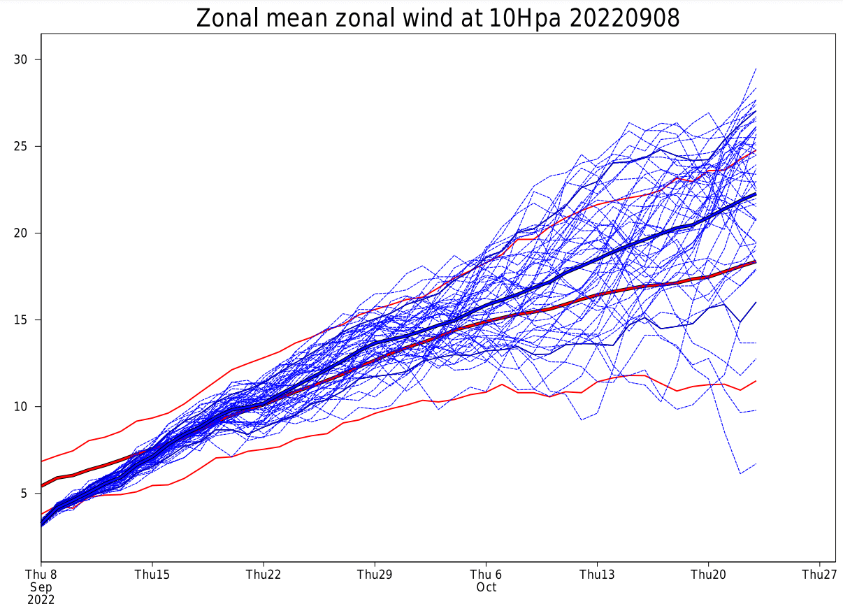
Compared to the long-term average, current forecasts show that the strength of the polar vortex is likely to be around average in late September.
That is seen in the image below, which shows the forecast of the stratospheric jet stream at 10mb (~30km). Red lines denote the average values. This might not mean much for now, but it shows that the polar vortex has a more energetic start than usual.
Lower down towards the surface, we can still see these winds, but we call it the jet steam. The image below shows the wind speed forecast for late September, at around 5km (3 miles) altitude.
Like in the Stratosphere, lower down, we still see the polar circulation (the jet stream) edging the Polar Vortex in the lower levels. Again, this shows that the overall weather circulation is connected on many levels and into a single system.
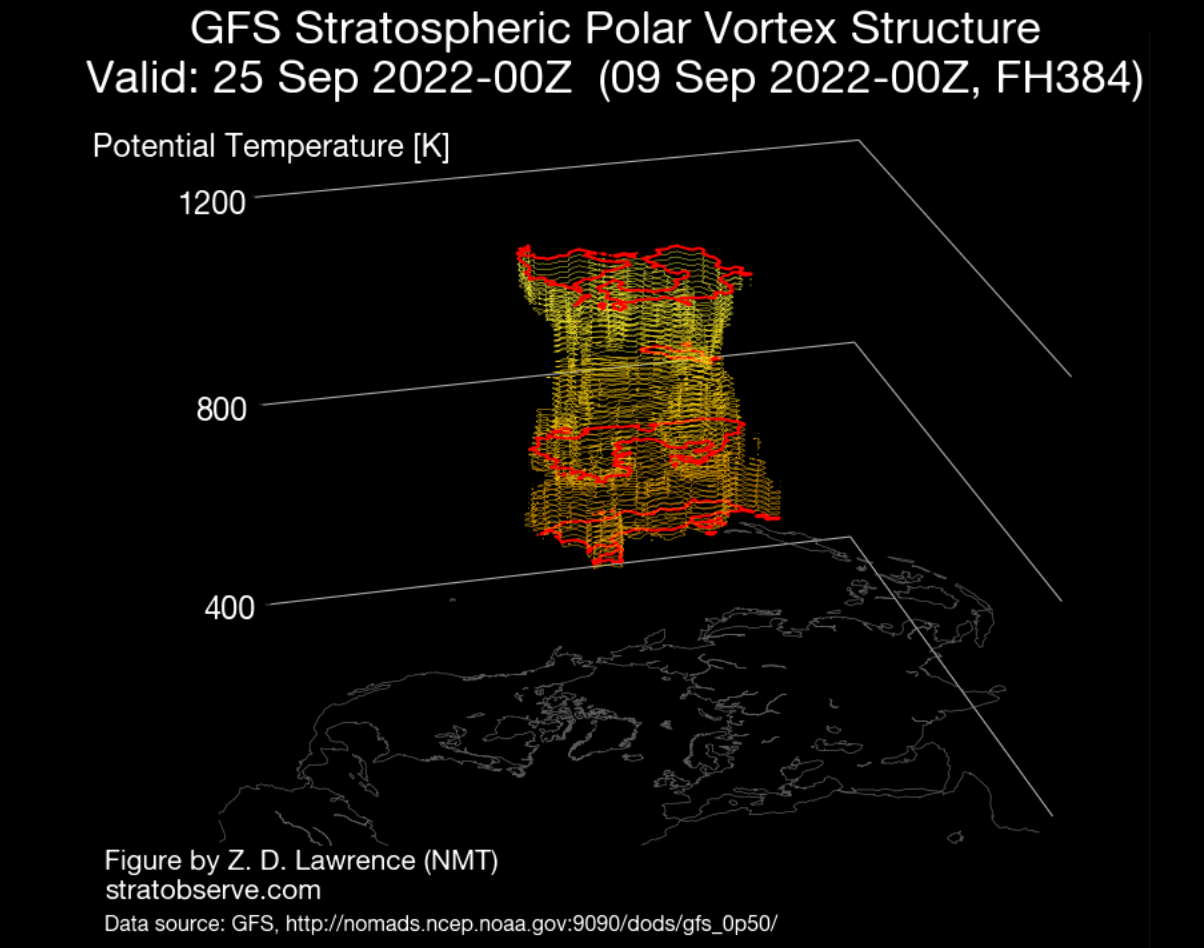
The 3-dimensional polar vortex forecast shows a good structure appearing higher up in the Stratosphere in late September. However, you can see that it is not connected down yet, as the structure is just building while the Northern Hemisphere is cooling further.
Now we know what the Polar Vortex is and how it works. But why do we care about it? As you will now see, the Polar Vortex has the power to do many things regarding weather, especially during Winter when it is strongest.
POLAR VORTEX AND WINTER WEATHER
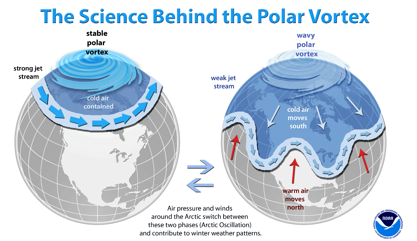
As we mentioned before, a Polar Vortex can be either strong or weak (collapsed). Each phase has its role, but we will look at both extremes, the strong and the collapse event.
A strong Polar Vortex usually means strong polar circulation. This usually locks the colder air into the Polar regions, creating milder conditions for most of the United States and Europe.
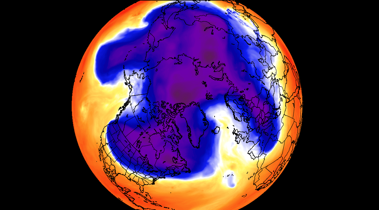
In contrast, a weak Polar Vortex can create a weak jet stream pattern. It has a more challenging time containing the cold air, which can now escape from the polar regions into the United States and/or Europe. Image by NOAA.
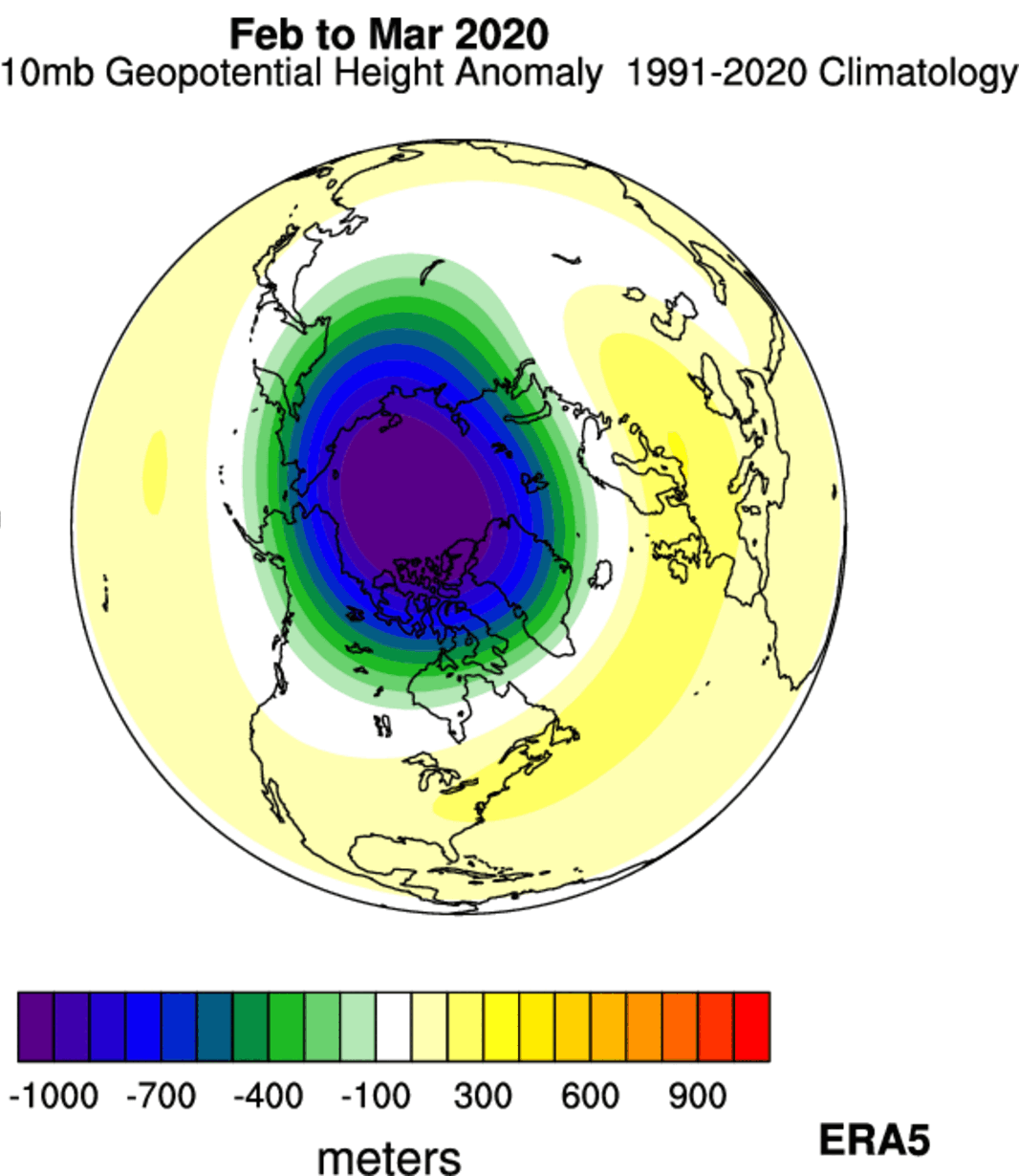
Starting with a strong Polar Vortex, it is exactly as the name suggests. It is colder and deeper, exerting more of its influence on our everyday weather. A good example occurred less than three years ago.
Below is an analysis of the Stratospheric polar vortex in February and March of 2020. As you can see, we can see significant negative anomalies in the core of the Polar Vortex. This means it is deeper and stronger than normal.
A stronger stratospheric vortex usually has an easier way of connecting down to the lower levels, changing the circulation. We can see that if we look at the pressure anomalies in the lower levels, as seen in the image below.
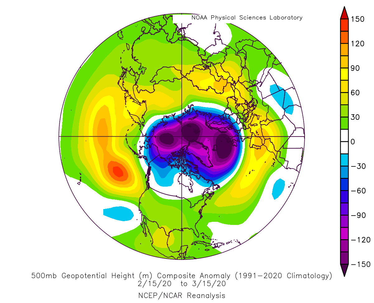
You can see the lower pressure locked into the Arctic circle, surrounded by a strong circulation. That circulation locks the cold air into the polar regions, making it harder to escape.
Speaking of temperatures, below we have the temperature analysis for this same period. Again, you can see much warmer than normal late winter weather over the United States, southern Canada, and Europe. This results from the cold air being locked further to the north.

You do not want to see this if you live in the mid-latitudes and you like your winter weather colder and served with snow. But there is another phase, perhaps even more impactful than the strong one.
SUDDEN STRATOSPHERIC WARMING EVENT
Typically, a polar vortex weakens due to a rise in temperature and pressure in the Stratosphere. That is called a Sudden Stratospheric Warming (SSW) event, which can collapse the Polar Vortex.
Simplified, a Sudden Stratospheric Warming event (SSW) is exactly what the name suggests. It is a sudden temperature rise in the polar Stratosphere during Winter. Warming of the Stratosphere means that the polar vortex is weakened and can also collapse under pressure from the warming event.
This creates a chain reaction, disrupting the jet stream, creating high pressure over the Arctic circle, and releasing the cold arctic air into Europe and the United States. An SSW event is usually triggered by specific massive pressure patterns in the troposphere, which can send a lot of energy upwards vertically into the Stratosphere.
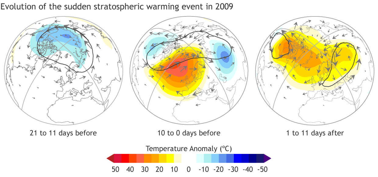
One such event occurred on January 2021. On January 5th, the preliminary date of the Sudden Stratospheric Warming event was marked, as the winds around the polar circle have reversed.
The stratospheric warming wave has crawled over the entire North Pole in the Stratosphere, effectively splitting the cold core of the polar vortex into two parts.
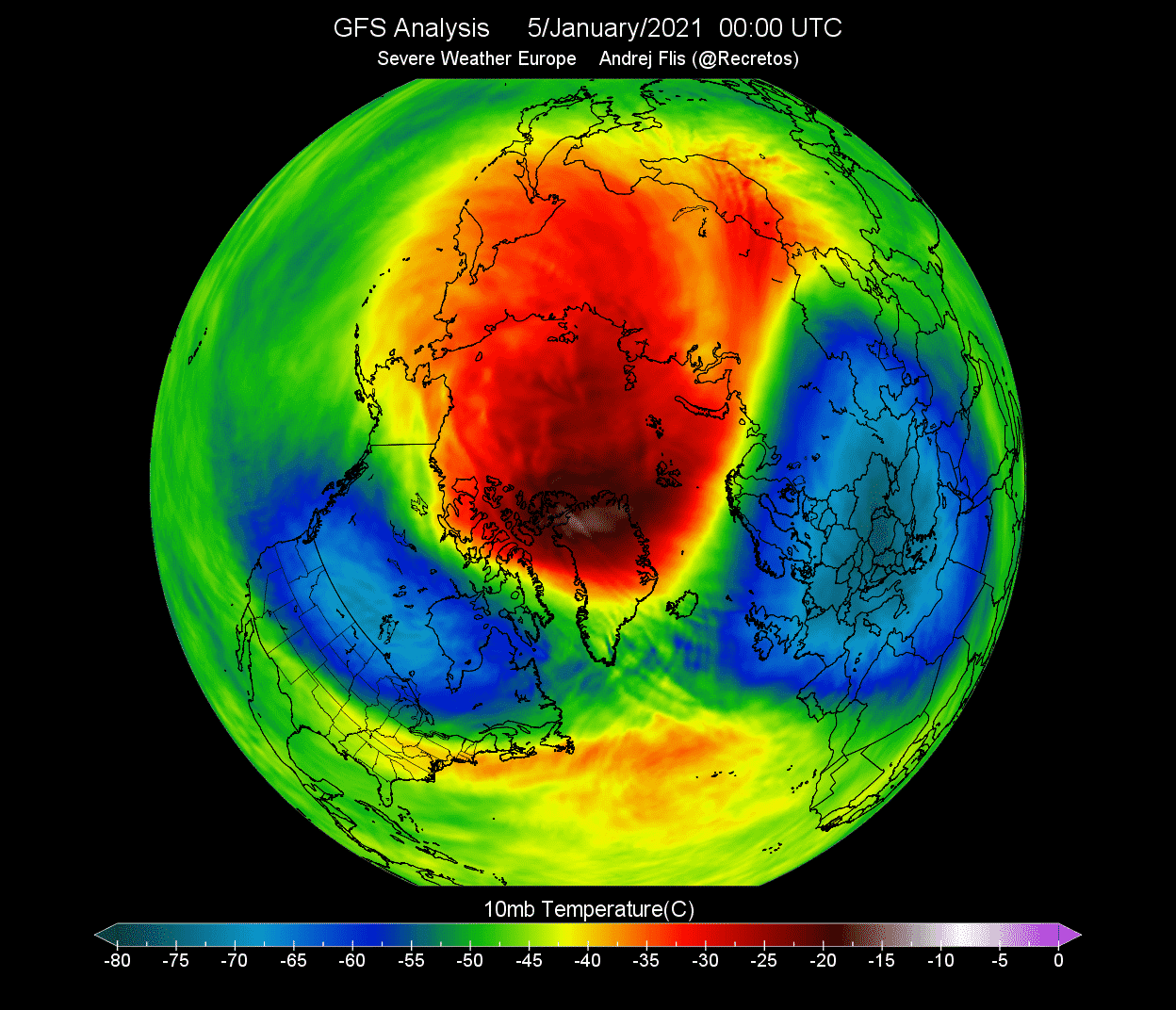
One part of the broken polar vortex has moved over North America and one over the European sector. At this point, this does not influence the winter weather on the surface so much. This is because it occurs at over 30km (18 miles) altitude. But the weather influence followed quite soon after.
Looking at the NASA temperature analysis for the polar Stratosphere, we can see a significant temperature spike at the 10mb (30km) level in early 2021. This shows a strong warming event, with temperatures staying above normal for weeks after.
When trying to find a connection between the Stratosphere and our winter weather, it helps to have more specialized images at hand. The image below shows an atmospheric pressure index. Negative values indicate lower pressure (blue colors), and positive values indicate higher pressure (red colors). We have altitude from the ground up to the top of the stratosphere (~46km/28mi) for the Winter/Spring 2021 period.
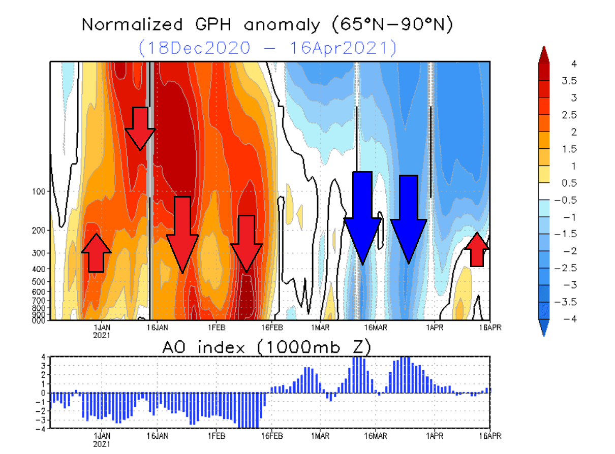
In early January, strong positive values in the Stratosphere are associated with the higher pressure buildup during the stratospheric warming event. The event and its influence slowly descended over time, reaching the lower levels by mid and late January.
This persisted well into February, influencing the weather patterns even when the stratospheric warming was already over.
We produced an analysis image of the January-February 2021 winter period, showing pressure and temperature anomalies. The image below shows the pressure anomalies, where a strong high-pressure system dominates the North Pole. This dominant high-pressure system originated from the stratospheric warming event and the polar vortex collapse.
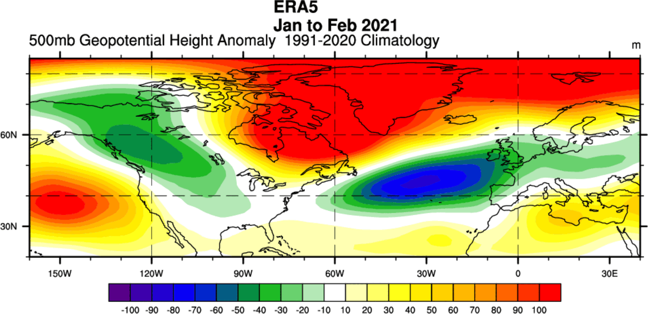
A strong high-pressure system over the Arctic can heavily disrupt the weather circulation and can unlock the cold air from the Arctic regions towards the mid-latitudes.
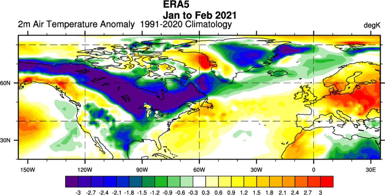
The image below shows the temperature anomalies in January-February 2021 period. Warmer than normal temperatures were present under the high-pressure system over the polar regions. SSW pushed cold Arctic air out into Canada and most parts of the United States.
The weather after a Polar Vortex collapse event is not always the same. A lot depends on the pre-existing weather patterns, as in some cases, the effect of stratospheric warming can be “deflected” or doesn’t mix into the lower parts very well.
We get an interesting picture if we combine all Stratospheric Warming events and look at the weather 0-30 days following the stratospheric warming events.
WINTER WEATHER AFTER A POLAR VORTEX COLLAPSE
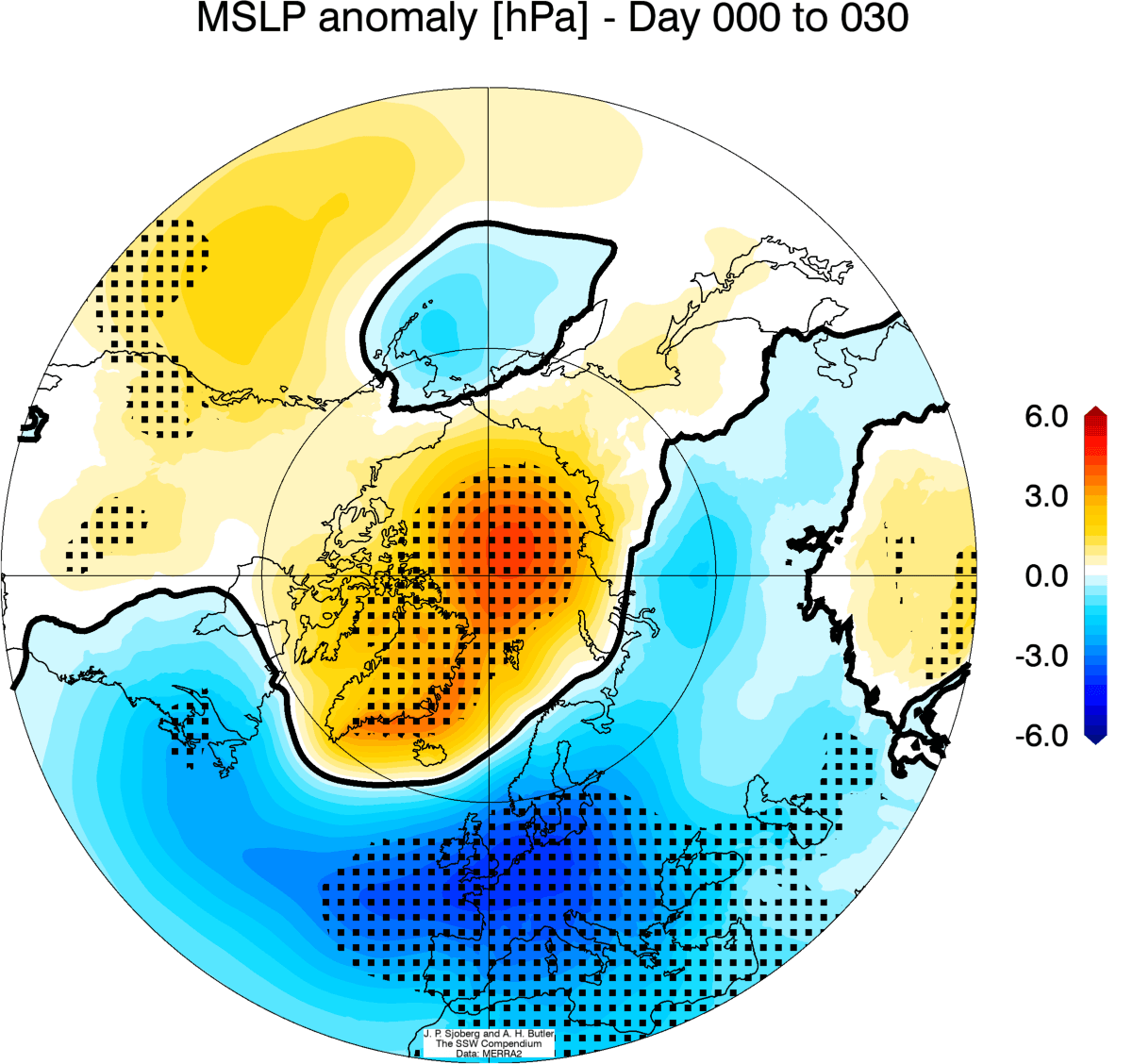
Below is the average pressure anomaly after a stratospheric warming event. It corresponds to a negative NAO pattern. This heavily disrupted circulation pattern helps to create a free path for colder polar air to move out of the polar regions.
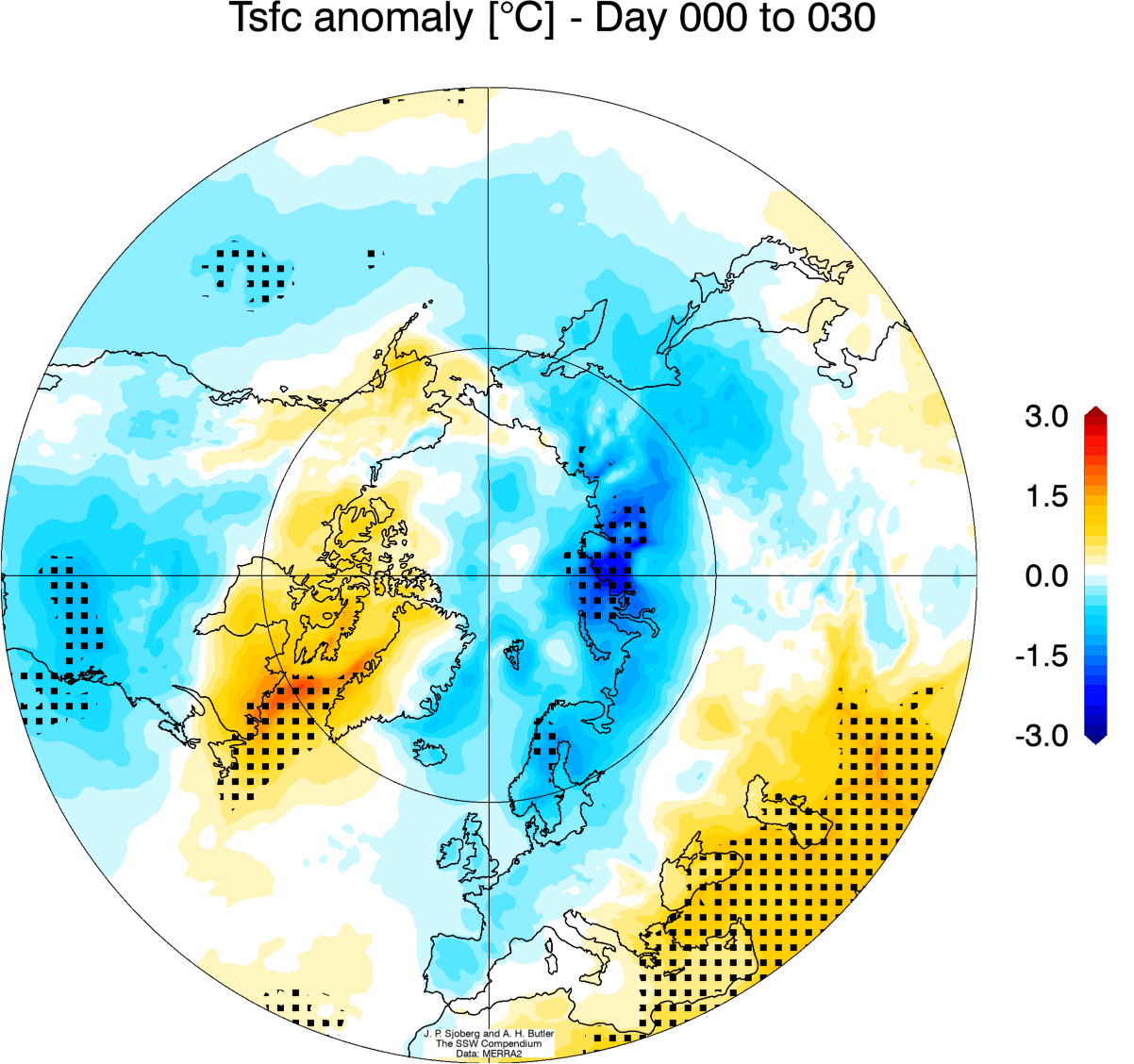
The corresponding average temperature 0-30 days after an SSW event shows that most of the United States are trending colder than normal, as is Europe. Note: this is an average picture of many SSW events. Each individual stratospheric warming event is different and does not automatically mean a strong winter pattern.
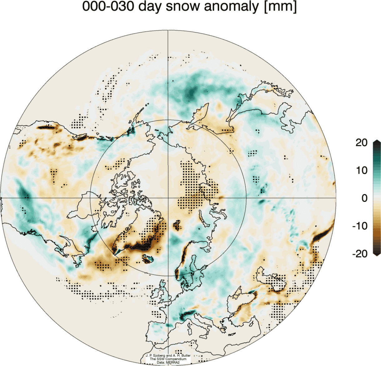
Looking at snowfall, we can see above-average snowfall over much of the eastern United States and also Europe. This is an expected response, as typically, after major stratospheric warming, the colder air has an easier path towards the south and into these regions.
So as you can see, having a strong or weak Polar Vortex can significantly change Winter weather over the United States, Canada, and Europe. However, it does not happen yearly, as it depends on many other factors.
So what is the early outlook for the Polar Vortex and winter weather in the upcoming 2022/2023 season?
POLAR VORTEX AND WINTER 2022/2023
We have discussed the La Nina phase of the ENSO and its influence in our first Winter forecast, so check it out for more details on the La Nina and the ENSO cycle. We will link it at the bottom of the article.
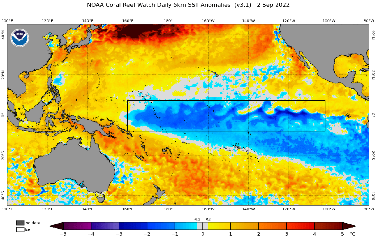
To keep it simple, La Nina is what we call the cold/negative anomalies in the tropical Pacific Ocean. It forms under certain conditions and can change the weather globally on a seasonal scale.
You can see the La Nina in the image below. We know what an effect La Nina might make on global circulation, and thus we can anticipate what it might mean for the Polar Vortex.
Historically, a La Nina winter has around a 60-75% chance of producing a stratospheric warming event. It has produced them in the past and also in the last Winter. The image below shows the typical Sudden Stratospheric Warming event frequency by month and by the ENSO event.
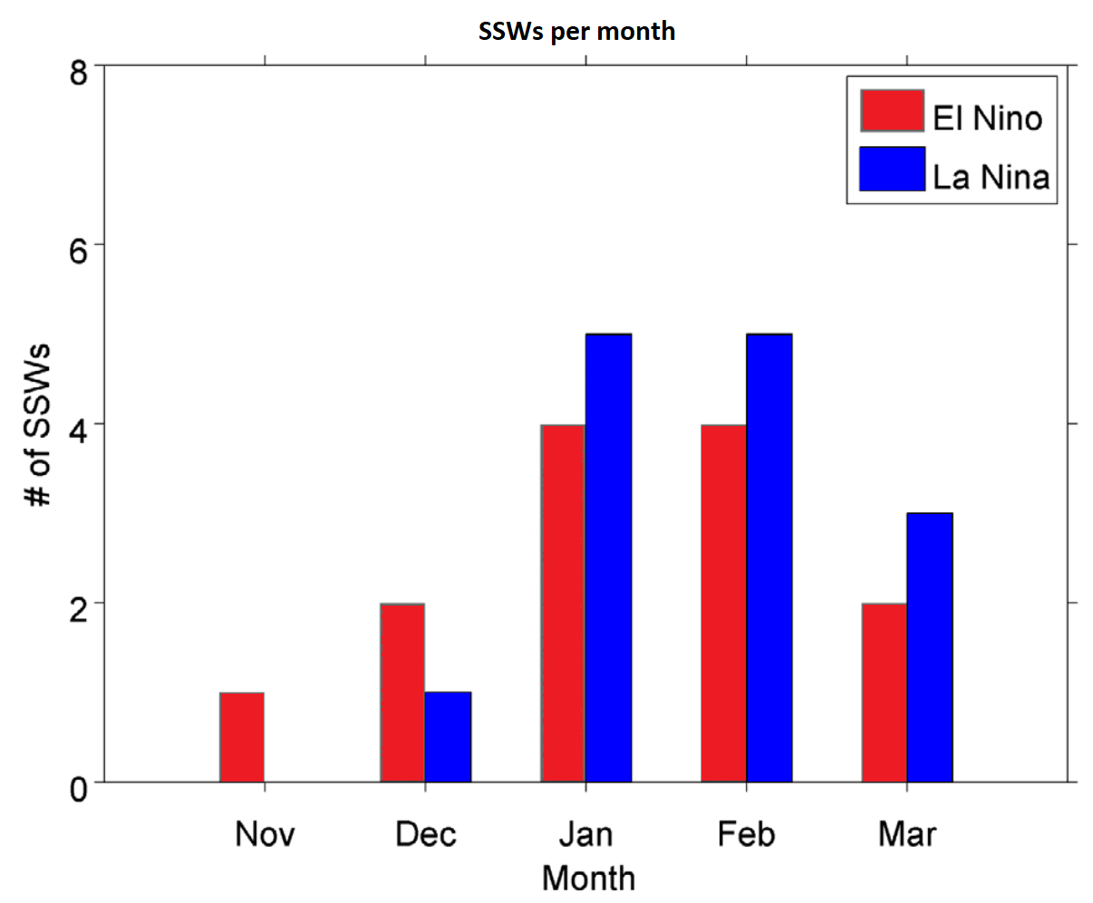
As you can see, a La Nina phase has a higher chance of producing a Polar Vortex collapse event. It also produces one later in Winter, compared to an El Nino.
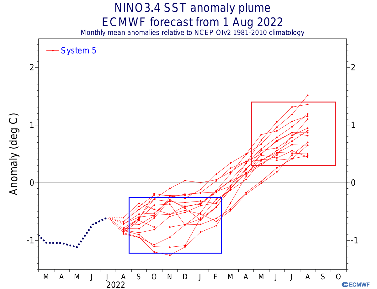
Below we have an analysis/forecast graphic by ECMWF, which shows the long-range forecast of the main ENSO region. The La Nina conditions will prevail over the Fall and Winter. But a weakening of the La Nina is expected for early next year, with an El Nino possible for later in 2023.
Current signals show an increased potential for a stratospheric warming event in mid-winter, based on an active La Nina. But a lot depends on positioning the massive high and low-pressure systems in the North Pacific.
This is where other short-term factors also come into play, like weekly weather variability, tropical convection, other ocean temperature anomalies, etc.
We have an interesting picture now of the forecast for the upcoming seasons. The ECMWF forecast for the 10mb stratospheric zonal winds shows a reduction in the power of the stratospheric winds in late Fall and early Winter.
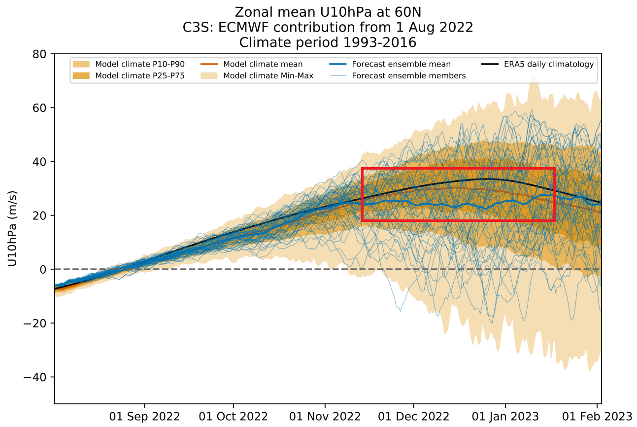
As winds are directly related to the strength of the Polar Vortex, we can see this as a signal for a weakening of the Polar Vortex. This would imply a more disrupted pattern and a chance of high-latitude blocking, thus more cold air in the United States and Europe.
It gives us a signal to keep an eye on, as these dynamics can have a large-scale and long-lasting impact on the weather pattern during Winter.
We will keep you updated on the global weather pattern development for the coming seasons, so make sure to bookmark our page. Also, if you have seen this article in the Google App (Discover) feed, click the like button (♥) there to see more of our forecasts and our latest articles on weather and nature in general.
Don’t miss: