After scorching weather across southern Europe, a multi-day severe weather outbreak spread across France, Germany, the Alpine region, and the Balkan peninsula. On July 13th, a cyclic supercell thunderstorm developed in Slovenia, tracked across five countries with its path of more than 1200 km long, dissipating in the Black Sea. The storm leads to record-breaking hailstones of 13-14 cm (5 inches) in Slovenia – the 4th event with giant hail over the last five years.
During its early stages, before the supercell took its long journey across the Balkan peninsula, the storm explosively intensified in southeast Slovenia. The growth was so rapid that giant hail developed. Residents reported hailstones up to nearly 14 cm in diameter.
- These are the largest hailstones observed in Slovenia on record and the most giant hail reported in Europe this year.
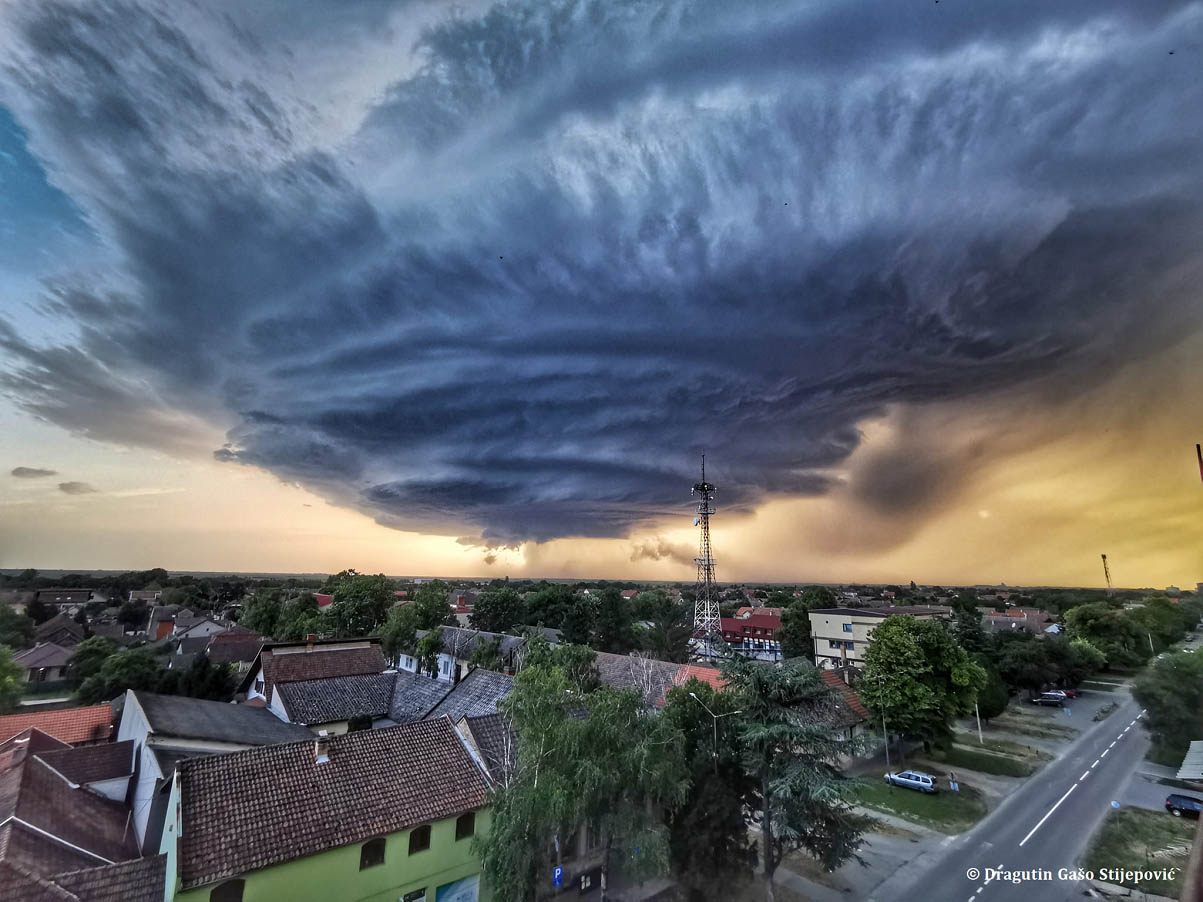
Storm chaser reports from various sources on social media have shown a textbook visual structure of the supercell along its path across five Balkan countries, from Slovenia across Croatia, southern Hungary, to northern Serbia into southern Romania.
The storm lived for more than 12 hours and tracked more than 1200 km from its birth in southwest Slovenia in the early afternoon on Thursday, July 13th, to its dissipation on the Romanian coast of the Black Sea on early Friday morning. Remnants of the storm have tracked even further into the Black Sea, making its path close to 1500 km.
The long-lived storm has developed a couple of cycles, as analyzed by radar imagery. It maintained itself while grazing its path through extremely unstable airmass over the central Balkan peninsula. Numerous large to giant hail reports have followed, along with severe wind damage.
Large hail is one of the most significant hazards with severe thunderstorms – while it is usually small and relatively harmless, it may grow to grapefruit-sized or even larger. It causes severe damage, injuries, and in extreme cases, even casualties.
Before we dig into the details that lead to the historic long-lived supercell storm, let’s first examine how hail forms.
HAIL FORMATION – HOW HAILSTONES FORM?
The hail or hailstone forms as supercooled water droplets within a thunderstorm updraft begin freezing onto a condensation nucleus. The supercooled droplets have a temperature below freezing (0 °C or 32 °F), but it remains in a liquid state.
As droplets come into contact with the growing hailstone, they freeze on it. Thus, making it grow larger. The growing hailstone is kept in the air by the storm’s updraft until it grows too big (and heavy) for the upward winds to keep it aloft.
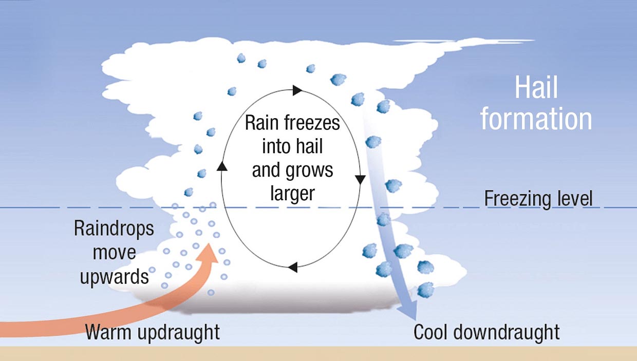
The hailstone typically makes a single round within the storm’s updraft, but it often makes several rounds. Each game forms a new layer of ice around the chunk of ice, producing a concentric onion-like structure.
Other versions of hailstones form and grow by many smaller hailstones sticking and freezing together into a large hailstone – such form is called an agglomerate. The giant hailstones sometimes even form long icy horns or spikes!

The most severe hailstorms with the most significant hail are generally associated with supercell thunderstorms. It takes a combination of very high to extreme instability, strong wind shear, and dry mid-levels for very large (giant) hail to form.
The largest hailstones ever reported on Earth exceeded 20 cm (8 inches) in diameter. The world’s largest hail was observed in Villa Carlos Paz, a resort city west of Córdoba, Argentina, on the 8th of February, 2018. The largest hailstones were up to 23.6 cm (or 9.3 inches).
GENERAL WEATHER EVENT ANALYSIS
Weather conditions across Europe this week were characterized by an extensive heat dome with a heatwave over the Mediterranean, paired with a large upper-level trough gradually moving east over western Europe.
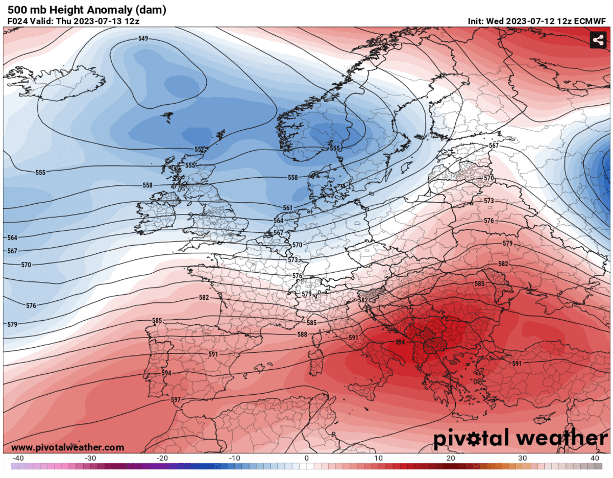
An associated cold front developed first thunderstorms in France on Tuesday, then led to a multi-day severe weather outbreak through Wednesday and Thursday. Conditions ahead and along the front supported severe weather, with very high to extreme instability within a strongly sheared environment.
Attached is the satellite animation from Tuesday through Thursday, revealing an outbreak of numerous thunderstorms. The video is provided by sat24.com.
The jet stream winds aloft gradually strengthened with height, favoring organized convective storms, including rotating or supercell thunderstorms.
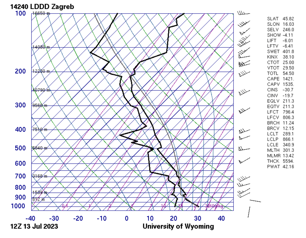
Below is the sounding (Skew-T) diagram for Zagreb, Croatia. The wind shear was extreme, while instability was 1500+ J/kg and beyond. The mid-levels were relatively dry, thus a perfect scenario for massive hail formation.
Our focus is the severe weather event that developed the most likely the longest-lived and tracked supercell thunderstorm in Europe on record. On Thursday, July 13th, a de-amplified short-wave trough was moving across central Europe. Grazing into a volatile and sheared environment across the Balkan peninsula.
A severe weather outbreak was expected in a belt from Slovenia across Croatia and Serbia to Romania in the afternoon, where abundant CAPE and shear was the best overlap. Severe winds and giant hail were forecasted.
STORM’S BIRTH IN SOUTHWEST SLOVENIA
The following chapters will focus on coverage of the historic long-lived supercell thunderstorm that was primarily initiated in southwestern Slovenia while gradually organizing into a monster hailstorm towards the southeast parts of the country. Continuing into Croatia, Hungary, Serbia, and Romania later on.

Around 10 UTC (local noon), an isolated thunderstorm developed (radar image above) near the town of Kozina, moving northeast. It was rapidly organizing into a supercell storm on its way toward Postojna. The storm split into two left and right-mover supercells in its early stages.
Before the parent storm took over the show, the northern cell developed a large cone-shaped funnel cloud near Povir, Slovenia, lasting around 5 minutes before it dissipated.

Further east the storm was progressing, the better conditions were present. Thus it was organized into a severe hailstorm and continued strengthening.
The 4-image radar sequence below shows the trajectory of the splitting supercell storm. The upper left image presents it near Postojna at 11 UTC. At 12 UTC, the left-mover storm gradually weakened into a cluster of storms in northern Slovenia, while the right-mover storm took over and strengthened.

The 3rd radar image above, scanned at 13 UTC, indicated that the supercell has become isolated and very powerful. This is a typical evolution of splitting supercells, where the right storm takes over and often becomes extremely severe, thus, why it has become the potential giant hail producer.
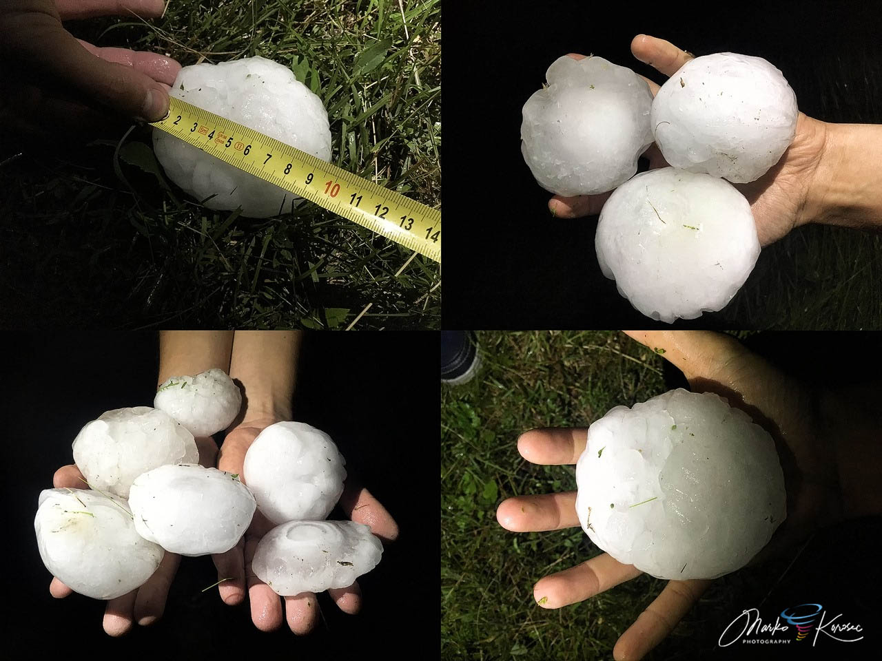
INTENSE SUPERCELL PRODUCES A RECORD-BREAKING GIANT HAIL OVER KRSKO, SLOVENIA
The most concerned conditions were across southeast Slovenia, further into Croatia, and towards Serbia. Once the storm moved into this environment, it took a higher gear. The storm’s core directly hit the city of Krsko, Slovenia, and the surroundings with the full force of very large hail.

Soon, reports were coming that giant hail of grapefruit-sized hailstones likely occurred.
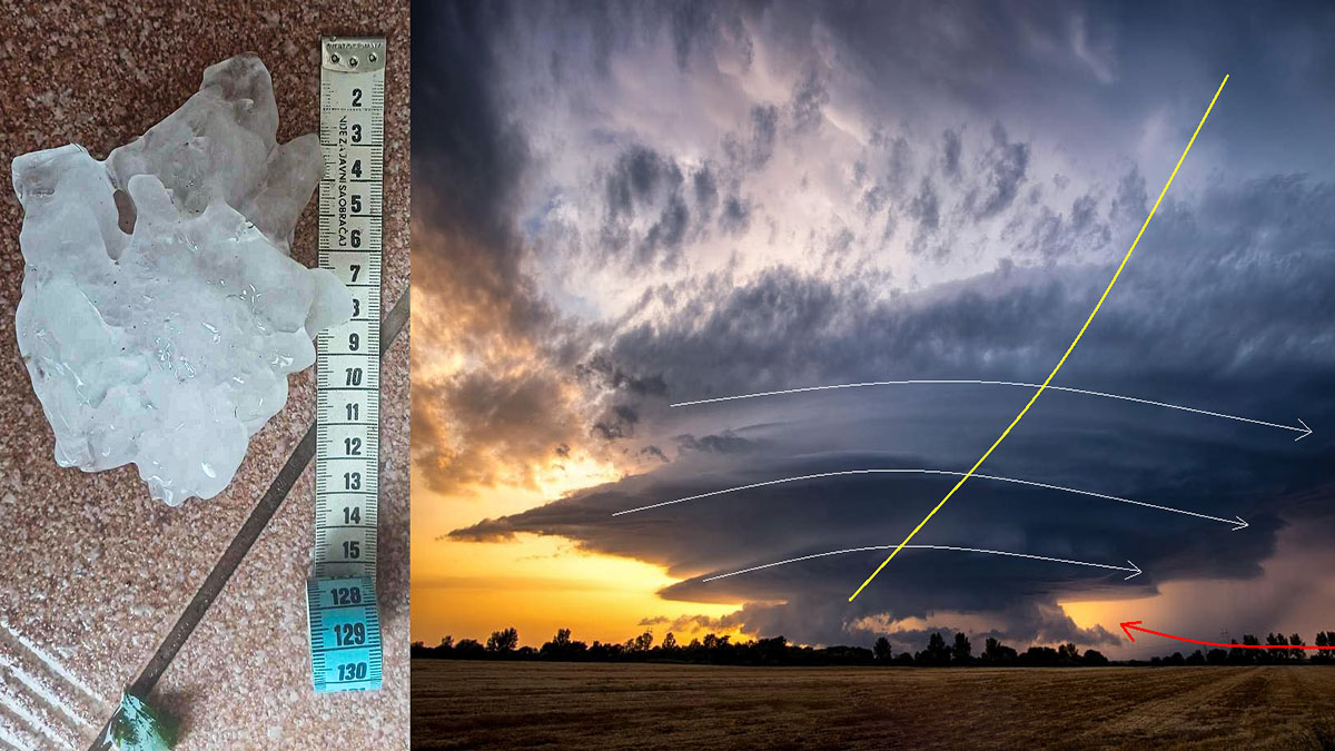
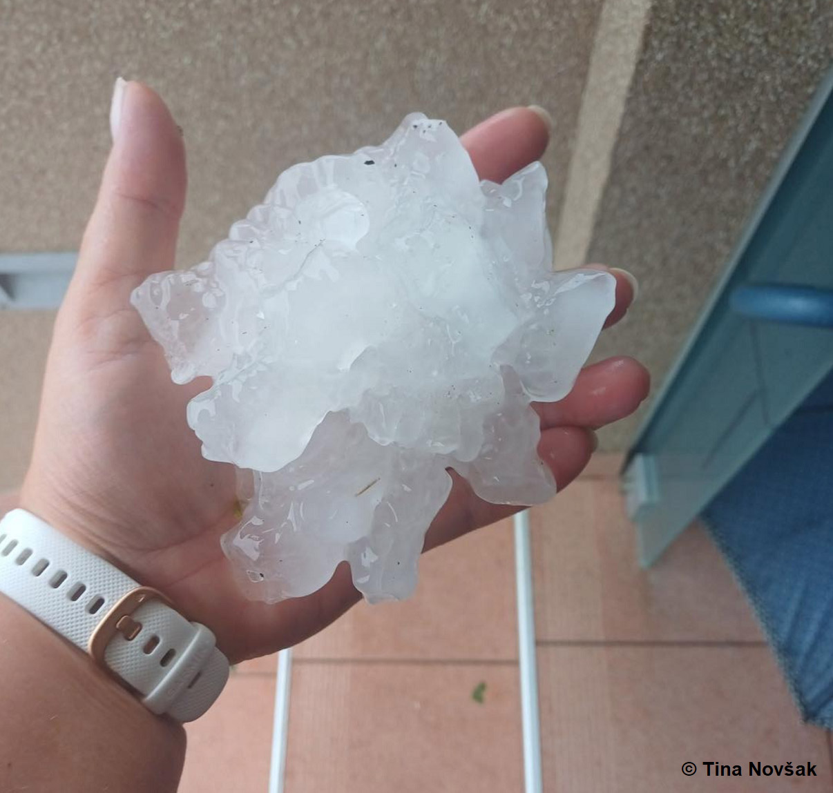
The below photograph from a small village Gorenja Lepa Vas near Krsko was taken by a resident, indicating the exceptional size of the 13-14 cm hailstone with spikes. Media were flooded with destructive hail photos and videos.

With this photographic evidence (above) and measurement taken right after the event, this hailstorm has become the largest hailstone on record for Slovenia.
Damage from winds and severe hail was significant in the city, with hundreds of roofs and cars destroyed. Devastating consequences occurred in agriculture.
Note: Predgrad and Stari trg ob Kolpi held the previous record on June 12th, 2019 (below). The hailstones were 11-12 cm in diameter but measured roughly 2,5 hours after the event. Given the likelihood of melting processes in this timespan, the giant hailstones were estimated to be around 13 cm at the time of the event.
Similar events in recent years were also on June 8th, 2018, in Crnomelj (approximately 12 cm in diameter) and Domzale (roughly 11 cm in diameter) on July 29th, 2020.
Therefore, Slovenia’s record-breaking July 13th giant hail event was the 5th in the last five years.
This ~14 cm hailstone is also the largest hail observed in Europe in 2023! And also just shy below the all-time European record of 15 cm reported in Romania on the 26th of May, 2016.
SUPERCELL WITH GIANT HAIL CONTINUED TRACKING SOUTHEAST INTO CROATIA, SERBIA AND ROMANIA
With the impressive environmental conditions ahead of the thunderstorm, there was barely anything to stop the rotating processes in the supercell. Therefore, the hailstorm continued across Croatia and touched Hungary into Serbia.
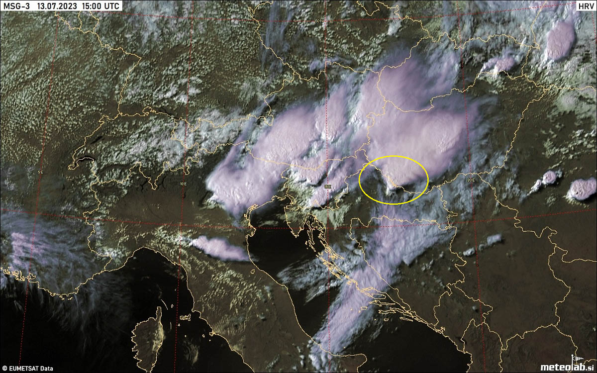
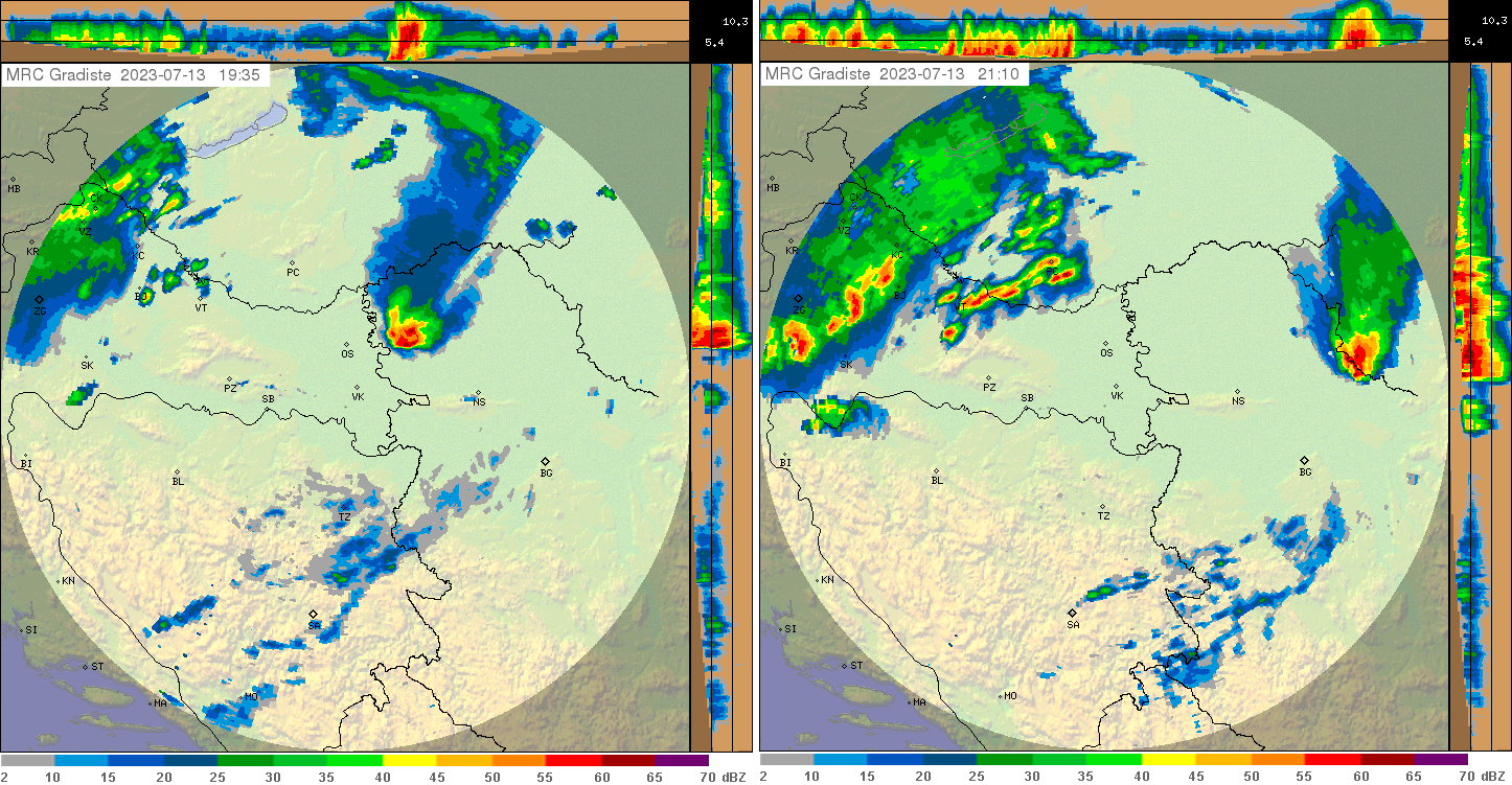
The radar at 14 UTC, when the storm was just northeast of Zagreb, reveals an impressive core. Giant hail was ongoing there. Thankfully, the large city of Zagreb was missed this time.

Attached is the radar sequence and visible satellite image of the supercell, continuing tracking across eastern Croatia.
Radar imagery from the Croatian network depicts a textbook flying eagle signature on the far right image. Storm has picked up its strength and especially structure.

At the time of the image, it was located between Bjelovar and Virovitica, Croatia. Partly also crossing into extreme southern Hungary, making the third country affected.
Farther west of the storm, more storms followed along the cold front ejecting into North Italy and Slovenia from the Alps.
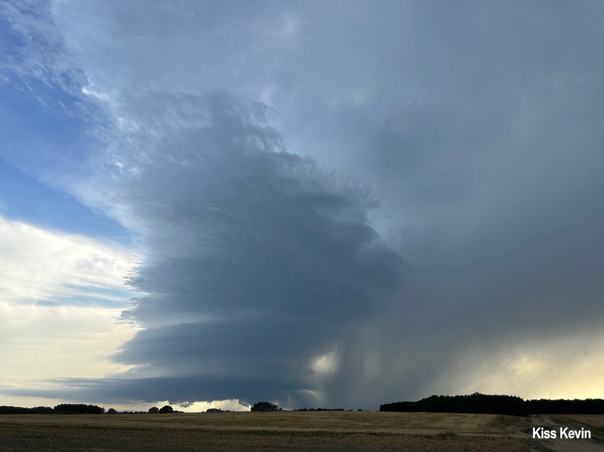
Here are a couple of photographs from along the supercell track. The first one is from far eastern Croatia, along the border with Hungary—a spectacular textbook supercell structure taken by Hungarian storm chaser Kevin Kiss.
Supercell continued to the north of Osijek before entering northwestern Serbia.
It was a pretty well-organized storm, remaining isolated throughout its track across Serbia before moving towards northwest Romania.
The following two photographs were taken in the northwestern parts of Serbia, the first near Kucura.
Therefore, the 4th country is affected by the same isolated storm.
This classic supercell structure was seen from north Serbia, some ten km north of Novi Sad.

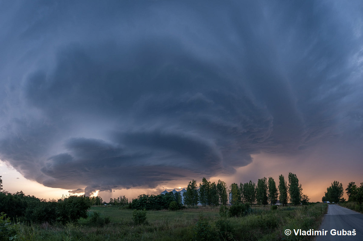
And the final image is from Zmajevo, Serbia, where the storm was beyond incredibly well-sculptured. Kudos to the local storm chaser Matija from Vojvodina meteo group.

In the early evening, supercell exited Serbia and grazed into its 5th country, Romania—continued tracking towards the Black Sea overnight.
MOST LIKELY THE LONGEST-LIVED SUPERCELL ON RECORD IN EUROPE
With the above analysis, this was an outstanding severe weather event. Not only as it set a new giant hail record for Slovenia and Europe in 2023 but especially for its longevity.
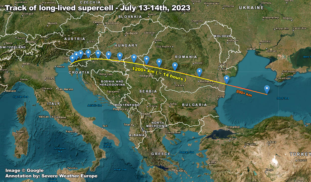
We have created the below image with the track of this long-lived supercell from its birth near Kozina, Slovenia, to its dissipation after ejecting Constanta on the Romanian coast of the Black Sea.
The track length from Kozina to Constanta is roughly 1200+ kilometers (750 miles), and it was done in about 14 hours. Additionally, the final 200 km (120 miles) are marked with different colors as it is unclear if the activity there was still the parent storm tracking.
Nonetheless, an outstanding long track of one single, although cyclic supercell thunderstorm.
The image below represents the lightning activity recorded by the Blitzortung network from the later afternoon of July 13th to midday Friday, July 14th. The continuous track of the lightning strikes indicates where the storm was tracking.
As we have seen from the earlier radar analysis above, the storm has initiated in southwest Slovenia around noon, continues across southeast Slovenia, east-northeast Croatia, northern Serbia across southern Romania, and finally dissipates in the western Black Sea around 14-16 hours later.
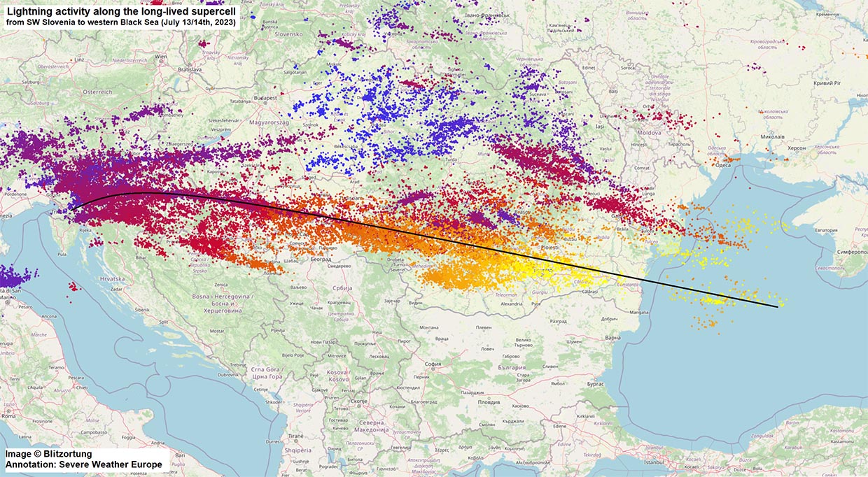
If the track from the Romanian coast to the end of lightning activity was also connected to our storm or were some new cells re-developing from it is yet to be analyzed. But data indicates that the storm had a continuous track at least until the coast.
The image below is another radar composite across the Balkan peninsula provided by Windy. It represents the supercell approaching SE Slovenia at 2 pm local time first. The bottom-left image represents when the storm crossed the Slovenia-Croatia border after 3.30 pm.
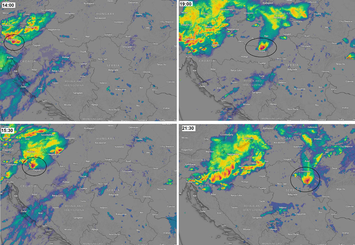
Upper-right image at 7 pm indicates the storm’s location just north of Osijek before entering northern Serbia. The last image, bottom-right, represents the location when the supercell was already reaching western Romania, south of Timisoara, at 9.30 pm.
That is 7,5 hours from the first to the last image. But remember, as we discussed above, the storm’s initiation was at noon, so +2 hours before that.
The upcoming new week will steeply increase European temperatures, with at least several days of low thunderstorm activity. Peak temperatures are expected to exceed +40 °C in many southern European countries.
Windy, Pivotalweather, and Blitzortung provided images used in this article.
See also: